

Gibralter (Carte Nouvelle de l`Isle de Cadix & du Detroit de Gibraltar), Homann Heirs, Nuremberg, ca. 1730. 18.8 x 22”. (HC) This extremely attractive map of the Strait of Gibraltar was a collaborative effort between Jean de Petit (royal engineer and architect) and Johann Friedrich Weidler (mathematician and astronomer at Witenberg). It was engraved by R.A. Schneider. The map covers the tips of southern Spain and northern Africa in great detail showing forts, cities, farms, mountains, local roads and rivers. The numerous fortifications guarding this strategic waterway are the focus of the map, which is richly adorned with a brilliant compass rose, three large sailing ships and a fine title cartouche depicted on an animal hide. Bold original color with a few spots of foxing and light printer`s ink residue. There is a tear in right blank margin that just touches neatline. (B)
534325 Preisdatenbank Los(e) gefunden, die Ihrer Suche entsprechen
534325 Lose gefunden, die zu Ihrer Suche passen. Abonnieren Sie die Preisdatenbank, um sofortigen Zugriff auf alle Dienstleistungen der Preisdatenbank zu haben.
Preisdatenbank abonnieren- Liste
- Galerie
-
534325 Los(e)/Seite

Cyprus (Cypri Insulae Nova Descript), Ortelius, Theatrum Orbis Terrarum, Antwerp, 1573. 19.5 x 13.8”. (HC) This bold map of Cyprus is based on Giacomo Franco`s map circa 1570. It is embellished with three sailing ships, a sea monster and three elaborate strapwork cartouches, one of which encloses an inset map of the Greek island of Lemnos. The map of Lemnos was drawn directly by Ortelius from a written account by the French naturalist and traveler, Pierre Belon (1553). Engraved by Jan van Deutecum. Dutch text on verso. First state, published in 1573. Ref: Van den Broeke no.149.1; Stylianou, pp. 60-62. Lovely old color on watermarked paper with light damp stains in blank margins, barely entering map at bottom corners. (A)
![Cyprus and Crete (Cyprus Insula [on sheet with] Candia, Olim Creta), Ortelius, Theatrum Orbis Terrarum, Antwerp, ca. 1573. 17](http://lot-images.atgmedia.com/SR/36385/2862480/684-2012510165843_468x382.jpg)
Cyprus and Crete (Cyprus Insula [on sheet with] Candia, Olim Creta), Ortelius, Theatrum Orbis Terrarum, Antwerp, ca. 1573. 17 x 14.3”. (HC) This folio sheet contains maps of Cyprus and Crete one above the other. Ortelius based these maps on the cartography of Camocio and Bordoni. The map of Crete shows a labyrinth as well as the caves said to be where the aboriginal inhabitants lived. This plate only appeared in the Theatrum until 1584. Dutch text on verso. Ref: Van den Broecke no.148; Stylianou no.65. Lovely old color on watermarked paper with light damp stains in blank margins, barely entering map at bottom corners. There are a few minor spots, and an edge tear at top confined to the blank margin that has been repaired on verso with old paper. (+B)

Crete (Candia met de Omleggende Eylanden), Doncker, Nieuw Groot Stuurmans Straets-Boeck, Amsterdam, ca. 1664. 20.2 x 15.5”. (HC) This very rare sea chart features Crete and surrounding islands. It is decorated with a strapwork and garland style title cartouche, three different scales of miles, two compass roses with north oriented to the right, and is filled with rhumb lines. There is a tiny hole to the right of Crete, a few faint spots, and some very light marginal soiling. (+B)

Crete (Candia, olim Creta), Blaeu, Amsterdam, ca. 1680. 20.8 x 15”. (BW) Decorative map of the strategically important island of Crete that controlled the maritime routes and access to the Adriatic Sea. It is also the legendary birthplace of Zeus, father of the gods in Greek mythology, and the site of many legends. The mythological labyrinth where the Minotaur was confined is located near the center of the map. The elaborate title cartouche is flanked by two empty dedication cartouches. There is no text on back indicating it was issued after the demise of the great Blaeu publishing empire, as this was among the plates auctioned in 1677 following the fire that destroyed the printing house. Ref: Zacharakis no.247. Light scattered foxing with paper added in bottom corners to repair several chips, away from map image. Backed with Japanese tissue. (B)

Eastern Mediterranean & Middle East (De Beschryving van de Reysen Pauli, en van de Andere Apostelen…), Avelen, Leiden, ca. 1700. 18 x 14”. (HC) This beautiful map of the eastern Mediterranean region details the travels of Apostle Paul. It is richly decorated with scenes from St. Paul`s travels in vignettes along the top and bottom and numerous sailing ships and a compass rose in the sea. Dutch text on verso. Ref: Poortman & Augusteijn no.153. Issued folding with wide margins. There are a few minute holes only visible when held to light and a couple of minor spots. There is a small, professionally repaired hole at a fold intersection in title cartouche. (+B)

Middle East (De Gelegentheyt van `t Paradys en `t Landt Canaan, Mitsgaders d`Eerst Bewoonde Landen der Patriarchen…), Stoopendaal, Rotterdam, ca. 1714. 18.3 x 14”. (HC) This Dutch Bible map covers the region between the Mediterranean and the Persian Gulf, depicting numerous Biblical sites, including the wanderings of the Children of Israel, Jonas & the whale, and the Garden of Eden. The map is richly embellished with a banner style title cartouche and four corner vignettes - the creation of Adam & Eve, Paradise, Eve offering Adam the apple, and the expulsion from the Garden of Eden. At bottom center is a large scene of the Ark. Dutch text on verso. Ref: Poortman & Augusteijn, no.131-GII2. Wide original margins with light toning along centerfold and faint offsetting. There is marginal soiling, a small chip in upper left corner, and a few short tears in blank margins that have been closed on verso with archival tape. (+B)
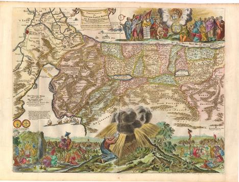
Holy Land (Perigrinatie ofte Veertigh-Iarige Reyse der Kinderen Israels uyt Egypten, door de Roode-Zee, ende de Woestyne tot in`t Beloofde Landt Canaan…), Avelen, Hildburghausen, ca. 1687. 17.8 x 12”. (HC) This splendid Dutch Bible map of the Holy Land illustrates the Exodus from Egypt and the wanderings of the Children of Israel in the desert. Canaan is shown divided into the Twelve Tribes. The lower part of the map is elaborately engraved with a scene of the encampment and Moses receiving the Ten Commandments at Mt. Sinai. At top is a scene of God`s word enlightening the world with Moses, Solomon, the apostles and evangelists. The map was based on Visscher`s map of 1650. Ref: Poortman & Augusteijn no.150. Issued folding with a printer`s crease adjacent to centerfold and light toning in blank margins. (A)

Holy Land (Het Beloofde Landt Canaan. Door-Wandelt van onsen Salich Maaker Jesus Christus…), Schut, Amsterdam, ca. 1730. 19.5 x 13.5”. (HC) This finely engraved and very detailed map of the Holy Land is embellished with sailing ships showing the route of St. Paul to Rome and a compass rose. Second state with Danckerts` imprint replaced by R. & J. Wetstein & William Smith (Amsterdam) and Samuel Luchtmans (Leiden). Dutch text on verso. Ref: Poortman & Augusteijn no.163. Issued folding, with light marginal soiling. (A)

Arabia (Tabula Asiae VI), Ruscelli, La Geografia di Claudio Tolomeo Allessadrino…, Venice, ca. 1574. 9.3 x 7”. (BW) This fine Ptolemaic map of the Arabian Peninsula, here called Arabia Foelix, is an enlargement of Gastaldi`s map of 1548. It is a fairly good representation of the peninsula, although Ptolemy overestimated the width of the southern part of the peninsula and distorted the shape of the Arabian Gulf. The map is presented on a trapezoidal projection with parallels and meridians (forerunners of lines of longitude and latitude) enumerated in the borders. Major towns are named, although not accurately located, and the rivers are entirely imaginary. Italian text on verso. Ref: cf Tibbetts no.30. A nice impression with printer`s ink residue and light toning along centerfold. There are a few small worm holes in blank margins that have been professionally infilled. (+B)

Asia (Asia wie es Jetziger Zeit nach den Furnemesten Herzschafften Abgetheilet und Beschriben ist), Munster/Petri, Cosmographia Universalis, Basel, ca. 1588. 14.2 x 12.5”. (HC) Handsome woodblock map based on Ortelius` 1570 map of Asia, which was the standard map of Asia for more than forty years. Petri added this map to Munster`s Cosmographia from 1588 onwards, probably in an effort to compete with Ortelius` great atlas. The cordiform projection shows Asia extended too far to the east, an error propagated with Ptolemy. Japan is in a `kite` form taken from Jesuit sources. Luzon is absent from the Philippines, and there are a great number of islands in the East Indies, but they are not well placed, due to the secrecy of voyages to the region. A portion of New Guinea is located in the lower right. The title is in the top margin and a text box describes the region. German text and illustration on verso. Ref: Yeo no.9. Light toning with a few faint spots. (+B)

Asia (Asia with the Islands Adioyning Described, the Atire of the People, & Townes of Importance, All of them Newly Augmented), Speed, A Prospect of the Most Famous Parts of the World, London, 1626. 20.5 x 15.8”. (HC) This beautiful carte-a-figures map is the first English printed map of Asia. It is flanked by costumed figures of Asian peoples with a series of eight city views forming a decorative frieze across the top including Damascus, Jerusalem, Aden, Hormus, Goa, Kandy, Banten and Macau. The map is based largely on Jodocus Hondius` map of 1623 with detailed depictions of the East Indies, the Philippines and the elongated peninsula form of Korea. Large lakes and rivers dominate the interior of China and the mythical Lake of Ciamay spawns five large rivers in India Without Ganges. The Great Wall of China is placed too far north. The Caspian Sea is greatly enlarged and oriented in an east-west direction. The map is further embellished with a title cartouche, numerous sea creatures and sailing ships and an elephant appears in the interior of China. Beautifully engraved by Abraham Goos with the imprint of Bassett and Chiswell, published circa 1676. The English text on verso provides a fascinating Anglo-centric view of Asia. Ref: Yeo no.30; Shirley (BL Atlases) no.T.SPE-2a-2; Moreland & Bannister, p. 148-50. Expert paper repairs and light toning all confined to the blank margins. (A)

Asia (A New Map of Asia, Divided into its Empires and Kingdoms, with all the European Settlements in the East Indies…), Sayer, London, ca. 1757. 37.5 x 22.5”. (HC) This uncommon, large map of Asia extends west to the eastern Mediterranean and the Red Sea. Sayer gives credit to D`Anville and Robert de Vaugondy for the improvements in cartography. The Korean peninsula is truncated, and Japan with Land of Yezo (Hokkaido) are too large. In the northeast corner are two fictitious islands, Company`s Land and Land seen by Juan de Gama, which were supposedly discovered by Jean de Gama. Vitus Bering finally debunked the myth of the islands in his explorations of the area in 1729, but the islands remained on maps for almost 50 years until Cook confirmed Bering`s reports. The direction of the trade winds is shown in the seas. Insets of the Dardanelles, the Gulf of Smyrna (Izmir), Bombay (Mumbai), and the Hooghly River detail important centers in the British Empires’ quest to dominate trade with Asia. A detailed table at bottom left outlines the divisions within Asia by the Eight Principal Parts and the European Settlements. The map is adorned with a compass rose and an elaborate title cartouche surrounded by images of the Orient. Printed on two sheets, joined as issued. Old color and wide margins with light toning along centerfold, a few minor creases, and one tiny hole. A few short tears in blank margins, and one that enters 2" into map image at right, have been professionally closed on verso with Japanese tissue. (+B)

Asia (Asia), Lucas, A General Atlas…, Baltimore, ca. 1823. 8.5 x 10.3”. (HC) A detailed map of Asia locating many cities, rivers, mountains and deserts. In the north, Novaya Zemlya is not fully delineated. In the south, the coast of Australia is depicted, along with a partially outlined New Guinea. Australia is labeled both New Holland and New South Wales, but with New South Wales incorrectly located on the northwest coast. Lucas` General Atlas is known as one of the finest general atlases produced in the U.S. at the time, due to the high quality paper, superior engraving quality, and attractive coloring style. Light toning with a few faint spots and light offsetting in blank margins. (+B)

Northern Asia (Tartaria sive Magni Chami Imperium), Blaeu, Amsterdam, ca. 1635. 19.5 x 15”. (HC) This great map of Tartaria covers all of eastern Asia between the Caspian Sea and northern China and Manchuria. Being one of the most remote regions of Asia, it was among the last to be properly explored and mapped. This map combines the knowledge obtained by the English and Dutch explorers as far as the Ob River with the balance of the map based on the reports of Marco Polo and the Greek classics. The deserts are filled with a wild assortment of devils and dragons, being held at bay from China by the Great Wall. Explorers flank the distance scale and the title is symbolically engraved onto the saddle blanket of a camel, representing the trade over the Silk Road. This map is nearly identical to Jansson`s map of the same title, but includes a scale across the top. French text on verso. Old color with wide margins, light toning and a centerfold separation confined to the upper blank margin. There are a few short tears in blank margins, far from image. An ownership label is adhered to the lower right corner, well away from the image. (+B)

Northern Asia (Tabula Tartariae et majoris partis Regni Chinae), Wit, Amsterdam, ca. 1685. 21.5 x 17.2”. (HC) Fine map of the region from the Caspian Sea through China and Japan. Eastern Russia is truncated with no Kamchatka peninsula and Yedso is shown according to the voyages of De Vries. The Great Wall is prominently shown separating China from the interior deserts. The mythical Chiammay Lacus is shown with its five major rivers. A strapwork title cartouche with two putti and a compass rose ornament the chart. There are professional repairs of a few centerfold separations and tears along centerfold, as well as tears and chips in blank margins. Light toning along centerfold and discoloration in a few areas due to cello tape used to repair tears, which has since been removed. Manuscript page number in upper right corner. (+B)

China (China Regio Asie), Ortelius/Galle, L`Epitome du Theatre, Antwerp, ca. 1595. 4 x 3”. (HC) This is the miniature version of Ortelius` important map focusing on China. The map is oriented with north to the right and extends to include parts of Indo-China. The Great Wall is prominently delineated and several huge lakes and rivers dominate the interior. A portion of Japan appears at bottom center. French text on verso. Ref: King (2nd ed.) pp. 64-65. Watermarked paper with light toning and a small worm track in right blank margin, far from map image. (+B)

China (Regni Sinae vel Sinae Propriae Mappa et Descriptio Geographica…), Haas/Homann Heirs, ca. 1750. 20.5 x 23”. (HC) This excellent and highly detailed map of China is based on the works of Du Halde and D`Anville. The map extends from the Gobi Desert in the north to Hainan Island in the south and includes Tai Ouan vel Ins. Formosa (Taiwan). Decorative cartouches at the bottom feature dragons and a phoenix. Light toning along centerfold with a few spots and faint damp stains. Trimmed close to the neatline at lower left. (+B)

Eastern China (Huquang, Imperii Sinarum Provincia Septima), Blaeu, Amsterdam, ca. 1655. 19.3 x 16”. (HC) Based on the remarkably accurate compilations of the Jesuit Father Martino Martini during his travels between 1643 and 1650, this map of the Hubei province is centered on the Yangtze River, Kiang Flu Pars. A legend at bottom left illustrates towns of various sizes, forts, and the locations of silver mines. The city of Vuchang (Wuhan) is located along the river. A strapwork title cartouche incorporates the scale of miles and is flanked by two rice farmers. Lovely color and wide margins with uneven toning and light offsetting. (+B)

China, Korea & Japan (China Veteribus Sinarum Regio nunc Incolis Tame dicta), Jansson, Amsterdam, ca. 1636. 19.5 x 16.3”. (HC) Several large lakes dominate the topography of this elegantly engraved map of China. The Great Wall forms the northern boundary of China. The fictitious Chiamay Lacus is shown with numerous rivers flowing south into India and Siam. Korea is depicted as a strangely shaped island separated from the mainland by a narrow strait. Taiwan is located in a roughly correct position, named as both Pakan al I. Formosaand Tayoan The three main islands of Japan are shown on the Ortelius/Teixeira model. The map is richly embellished with European sailing ships and Chinese sampans, a decorative distance scale, and a title cartouche flanked by a Chinese man and woman. German text on verso. Clean, wide margins with light show-through of text on verso. There is a small, professionally repaired hole in bottom left blank margin and a tiny hole in top blank margin. (A)

Japan & Korea (Iaponiae Insulae Descriptio), Ortelius, Theatrum Orbis Terrarum, Antwerp, 1595. 19 x 14”. (HC) This landmark map was the first map of Japan published in a European atlas. Ortelius received the map from Ludovico Teixeira, a Portuguese Jesuit cartographer and mathematician. While Teixeira had not personally traveled to Japan, he obviously had access to Japanese sources as the map presents the first reasonably accurate and recognizable depiction of the island nation with numerous Japanese place names. Korea appears as an island tapering to a point labeled Punta dos ladrones. The map is elegantly embellished with three large galleons, two elaborate cartouches and a boldly engraved border. This influential map was to become the basis for many other cartographers` maps of Japan for more than fifty years. This is the first state with Latin text on verso, published between 1595-1609. Ref: Walter OAG no.5, plt. 19; Van den Broecke no.165. Insignificant soiling in wide, blank margins and a minute pinhole near Hizu only visible when held to light. (A)

Japan & Korea (Corea and Japan), Thomson, New General Atlas, Edinburgh, 1815. 24.5 x 19.5”. (HC) A lovely map of Japan and Korea showing the discoveries of Broughton and Krusenstern who traveled in the region in 1796-97 and 1805-11, respectively. In Japan, Kyrushu, Shikoku, and Awajishima are significantly more correct than earlier maps. Nicely detailed with regions delineated, it shows towns, roads, rivers, lakes and mountains. Ref: Walter no.128. Original color with faint offsetting and light toning along centerfold. There is some minor creasing in top blank margin. (+B)
![Southeast Asia (Asiae XI Tab), Ptolemy/Mercator, Theatrum Geographiae Veteris…, Leiden, [1618]. 13 x 13.5”. (BW)](http://lot-images.atgmedia.com/SR/36385/2862480/778-20125101773_468x382.jpg)
Southeast Asia (Asiae XI Tab), Ptolemy/Mercator, Theatrum Geographiae Veteris…, Leiden, [1618]. 13 x 13.5”. (BW) Fine Ptolemaic map of the region of Thailand and Malaysia. The map shows an oddly shaped peninsula to the east of the Ganges and the Sinus Magnus (South China Sea), with a landmass to the east of that. This depiction is the legacy of Ptolemy`s idea of a landlocked Indian Ocean. Although he is most renowned today for the projection he popularized and for first using the term Atlas for a collection of maps, Mercator devoted much of his life to his Ptolemaic maps. The maps were beautifully engraved as nearly as possible to their original form and embellished with fine cartouches and cultural scenes. This map includes a caravan, camels, ships and boats. Ref: Mickwitz & Miekkavaara (Nordenskiold) no.232-27. There are two tiny holes near the centerfold, light damp staining and some scattered foxing primarily in the blank margins. Right margin is trimmed close to the neatline. (B)

Southeast Asia (Indiae Orientalis Nova Descriptio), Jansson, Amsterdam, ca. 1633. 20 x 15.5”. (HC) Decorative chart of the region including Indochina, the Philippines and the East Indies. Includes the new discoveries in New Guinea made by the Dutch "Duyfkens" exploration. The map is embellished with rhumb lines, sailing ships, sea monsters, compass roses and three cartouches. The cartouches feature indigenous people, mermaids and a sea monster. German text on verso. Ref: Schilder Australia no.24; Clancy Map 6.6; Tooley 746; Phillips (A) 445 [674-75]. Minor soiling and light show-through of text on verso. (+B)

Indonesia (Kaart der Zuyd-Wester Eylanden van Banda), Valentyn, Oud en Nieuw Oost-Indien, Amsterdam, ca. 1726. 21.5 x 17.5”. (BW) A fascinating map of the islands in the southwestern part of the Banda Sea including Sumba, Flores and Timor. Valentyn was an prominent historian of the Dutch East India Company (VOC) who is best known for Oud en Nieuw Oost Indien, which was published by Joannes van Braam and Gerard onder de Linden. He twice traveled to the East Indies and served as Calvinist minister to Ambon between 1686 and 1694. In preparing this monumental work, he was given privileged access to the previously secret archives of the VOC, containing transcripts and copies of important earlier Dutch voyages. Wide original margins with light offsetting and numerous tiny wormholes in unengraved areas of the map. There is a repaired tear that enters 1.5" into map at right. Issued folding. (B)

East Indies - Indonesia (Insulae Iavae cum Parte Insularum Borneo Sumatrae, et Circumjacentium Insularum Novissima Delineatio), Jansson/Valck & Schenk, Amsterdam, ca. 1700. 20 x 16.5”. (HC) This elegant chart focuses on the island of Java with parts of Sumatra, Borneo and Bali. The lack of interior detail correctly reflects the state of knowledge of the period. The Dutch capital in the East Indies is located at Batavia (Jakarta) where a small fort is shown. The beautiful chart is richly embellished with two fine cartouches featuring natives and Chinese merchants flanking the title and Neptune and mermaids surrounding the scale of miles. Originally issued by Jan Jansson, this is the later re-issue by Gerard Valk and Peter Schenk. A couple of unobtrusive spots and light offsetting. (+B)
![India & Sri Lanka (Tabula Asiae X), Gastaldi, La Geografia, Venice, [1548]. 7 x 5.3”. (BW) Rare little Ptolemaic ma](http://lot-images.atgmedia.com/SR/36385/2862480/788-201251017741_468x382.jpg)
India & Sri Lanka (Tabula Asiae X), Gastaldi, La Geografia, Venice, [1548]. 7 x 5.3”. (BW) Rare little Ptolemaic map centered on India with recognizable river systems, but completely lacking the sub-continental shape of the landmass. The top of a large Taprobanae Pars (Sri Lanka) appears at bottom. The map is presented on a trapezoidal projection with rope-like mountain ranges and strange creatures in the border, one of them being a bird with the face of a man. Italian text on verso. Ref: Karrow no.30/53; Mickwitz & Miekkavaara (Nordenskiold) II no.214-49. Printer`s ink residue on the plate and light toning along centerfold. (+B)
![Southern Asia ([On 2 Sheets] The East Indies, with the Roads…), Jefferys/Laurie & Whittle, London, 1794. 54.3 x 21&](http://lot-images.atgmedia.com/SR/36385/2862480/796-201251017817_468x382.jpg)
Southern Asia ([On 2 Sheets] The East Indies, with the Roads…), Jefferys/Laurie & Whittle, London, 1794. 54.3 x 21”. (HC) This impressive wall-sized map by Jeffreys was the most detailed to date. It extends to include parts of present-day Pakistan in the west to Burma and the Andaman Islands in the east, and reaches up to Tibet in the north. The map was of great importance during the British expansion in the area, and contains a combination of detailed, well-explored areas and large tracts of unknown land. Southern India, Sri Lanka and Bahar Bengal (Bangladesh) are well defined, with details of roads, caravan routes, oases, temples, cities, treaty lines, archeological sites, mountain ranges, lakes, swamps and rivers. The map is dedicated to the Directors of the East India Company. Printed from four plates, joined in two horizontal sheets. Later issue of the map first published in 1763. Issued folding, with light offsetting and minor soiling. There are a few tiny holes at fold intersections and some fold separations, most of which have been closed on verso with archival materials. Trimmed close to neatline at top. (B)

Indian Ocean (Carte Reduite de l`Ocean Oriental, depuis le Cap de Bonne Esperance, jusqu`a l`Isle Formose), Apres de Mannevillette, Le Neptune Oriental, Paris, 1775. 27.8 x 19.8”. (HC) A French sailor and hydrographer, D` Après de Mannevillette (1707-1780) used new instruments to correct the latitudes measured by previous explorers. His atlas Le Neptune Oriental, first published in 1745, was considered a major achievement and an indispensable resource for navigators. This uncommon sea chart shows great detail of the coastline from Cape Good Hope in Southern Africa north to the Arabian Peninsula, east to India and south to Australia. Printed on heavy watermarked paper with a few light spots and stains primarily in the blank margins. Remnants of hinge tape on verso. (+B)

Madagascar (I. S. Lauretij), Wright, ca. 1600. 5 x 3.5”. (HC) Charming miniature map of Madagascar (Portuguese name St. Laurence). North is oriented to the left and the Linea Aequinoctial cuts across the southern tip of the island. Benjamin Wright was an English engraver who worked in England, Amsterdam and Italy. While in Amsterdam he engraved many of the plates for the second edition of Cornelis Claesz` Caert Thresoor. The plates were also used to illustrate a geographical treatise by Petrus Bertius. Latin text on verso. Ref: King, p. 73. Light show-through of text on verso and a few faint spots. (+B)

Madagascar (Isle d`Auphine, Communement Nommee par les Europeens Madagascar, et St. Laurens, et par les Habitans du Pays Madecase), Sanson, Paris, 1697. 17.5 x 23”. (BW) This is a splendid, large-scale map of Madagascar and the surrounding islands in the Indian Ocean off the southeast coast of Africa. The map is filled with detail along the coasts and is decorated with an unusual compass rose, sailing ship and a figurative cartouche with native inhabitants. The map is based on the report from two early French accounts of the islands; Etienne de Flacourt, a French governor of Madagascar in 1648 and Francois Cauche, who voyaged to Madagascar in 1638. Extended margins and backed with old linen. The map is detached at corners from the extended margins, and the linen is also detached at the corners. There are a few small spots and light creasing throughout, and light damp stains in corners. (+C)

Northern Africa (Barbarie, Egypte, Nigritie, Guinee, Nubie, Abissinie), Robert de Vaugondy, Nouvel Atlas Portatif, Paris, ca. 1778. 14.3 x 9.5”. (HC) This map of northern Africa extends to include parts of the Mediterranean and the Arabian Peninsula. There are few details in the interior, with the exception of the Sahara Desert and a few rivers and mountain ranges. The cartouche was engraved by Arrivet, and the map was engraved by E. Dussy. Ref: Pedley no.433. Original outline color with light toning and a couple of minute worm holes only visible when held to light. (+B)

Northwestern Africa (Fezzae et Marocchi Regna Africae Celeberrima, describebat Abrah: Ortelius), Jansson, Antwerp, ca. 1636. 19.8 x 15.3”. (HC) Highly decorative map of Morocco oriented with north on the right and including the Strait of Gibraltar. It is based on the cartography of Abraham Ortelius, who is credited in the cartouche. The Atlantic is filled with five sailing ships, including two engaged in battle. Two dancing satyrs brandishing their javelins flank the large title cartouche. Latin text on verso. Old color with wide margins, some light stains, and a few creases at left. (B)

Western Africa (l`Afrique, ou Lybie Ulterieure ou sont le Saara, ou Desert, le Pays des Negres, la Guinee, et les Pays Circonv.…), Sanson/Mariette, Cartes Generales de Toutes les Parties du Monde…, Paris, 1655. 21.5 x 13.5”. (HC) Handsome map of Western Africa filled with information, much of it spurious, in the Sahara Desert, the Niger River and the coast of Guinea. Of particular interest are several incomplete rivers in the desert regions that appear and then disappear. The map is beautifully engraved with a title cartouche fashioned in the form of an oriental carpet. Ref: Pastoureau no.Sanson V A [18]. Watermarked paper with light toning along centerfold and a few tiny cracks near centerfold that have been closed on verso with Japanese tissue. There are two small holes at top left that have been archivally repaired. (+B)

Central Africa (Abissinorum sive Pretiosi Ioannis Imperium), Mercator/Jansson, Atlas Minor, Amsterdam, ca. 1628. 7.5 x 5.3”. (HC) Charming map of the legendary land of the Christian king, Prester John, with his fortified kingdom shown atop a mountain. The Nile River emanates from two large lakes near the Lunae Montes (Mountains of the Moon). The map is adorned with a large strapwork title and scale cartouche. Engraved by Petrus Kaerius. Latin text on verso. A few faint spots and light show-through of text on verso, with marginal soiling. (+B)

Southern Africa (Le Pays des Hottentots aux Environs du Cap de Bonne Esperance), Bellin, Paris, ca. 1755. 13.8 x 9.8”. (HC) A beautifully engraved copper-plate map of the Cape of Good Hope from Saint Helena Bay to Mossel Bay. Dutch settlements are mostly confined along the coast and southern regions. The inland regions are depicted as deserts, savannas, forests and mountain ranges with tribal names indicated and a few Boer colonies. Watermarked paper with light toning, scattered foxing and a chip at bottom centerfold that has been repaired with old paper, with a minor amount of neatline in facsimile. (B)

Pacific Ocean (A New & Accurate Chart of the Discoveries of Captn. Cook & other Later Circumnavigators: Exhibiting the Whole Coast of New South Wales, Shewing the Situations of Port Jackson, & Norfolk Island, where the New Settlements are Formed…), Guthrie, London, ca. 1795. 13.3 x 16.8”. (BW) This map illustrates the discoveries of eighteenth century exploration in the Pacific. Part of the southern coast of Australia is conjectural, and Diemans Land is still connected to the mainland, which wasn`t disproved until Flinders and Bass circumnavigated Tasmania in 1798-99. Numerous other islands in the South Pacific are only partially delineated. The northwest coast of North America also depicts recent discoveries, with several small gaps in the coastline. This map was originally published by Alexander Hogg in A New, Complete, and Universal Collection of … Voyages and Travels… Engraved by T. Conder. Issued folding, now pressed with light offsetting and a minor spot of soiling. There is an archivally repaired tear that enters 2.5" into map at right with a narrow right margin. Backed in Japanese tissue. (B)
![North Pacific Ocean ([Lot of 3] Carte Generale des Decouvertes de l`Amiral de Fonte… [and] Nouvelle Representation des](http://lot-images.atgmedia.com/SR/36385/2862480/830-2012510171048_468x382.jpg)
North Pacific Ocean ([Lot of 3] Carte Generale des Decouvertes de l`Amiral de Fonte… [and] Nouvelle Representation des Cotes Nord… [and] Partie de la Carte du Capitaine Cluny…), Robert de Vaugondy, Diderot`s Encyclopedia (Supplement), Paris, [1772]. x ”. (BW) Three great maps from this interesting series prepared by Didier Robert de Vaugondy. A. Carte Generale des Decouvertes de l`Amiral de Fonte, et Autres Navigateurs Espagnols, Anglois et Russes pour la Recherche du Passage a la Mer du Sud, dated 1752 (15" x 11.3"). This is one of the more remarkable combinations of fact and fiction ever published. This map of the North Pacific and Northwest had as its source a 1708 article in the Monthly Miscellany that purported to be a newly discovered account of a voyage in 1640 by the Spanish Admiral, Bartholomew de Fonte. Thereafter, the newly presented information was changed and elaborated upon, notably by this series of maps which appeared in Diderot`s Encyclopedia. In its concept, it promoted the hopes of a Northwest Passage and depicts the existence of Mer de l`Ouest or the Sea of the West. The tracks for the Russian exploration in 1741 and other explorers are traced in the Pacific. Inset at upper left is a small map, "Carte dressee Sur la lettre de l`Amiral de Fonte par l`Ecrivain de la Californie" detailing the purported track of Admiral de Fonte. The title credits Delisle as the source for the map. There was much controversy at the time regarding the veracity of the voyages by de Fonte. In 1750, Joseph-Nicolas Delisle presented a paper and map at the Academy of Sciences in Paris that consolidated the vast amount of geographical information he had acquired in Russia. The paper caused a sensation, but the map, drawn by Philippe Buache and designed to show the "coherence of Russian discoveries with those of de la Fuente" (de Fonte), was met with skepticism. Delisle hired Bellin to re-work the map, presenting it to the Academy in 1752. That same year an annoyed Buache drew his own map and presented it along with a paper to the Academy. The controversy was further enflamed by Robert de Vaugondy`s own presentation to the Academy the following year when he expressed his doubts about the truth of de Fonte’s voyages and criticized the maps illustrating it. See Pedley pages 74-78 for more on the politics and personalities in this fascinating story. Ref: Hayes pp. 26-27; Pedley no.454. Condition: Watermarked paper with wide margins, light centerfold toning and a spot in inset map at top left. (B+) B. Nouvelle Representation des Cotes Nord et Est de l`Asie, pour Servir d`Eclaircissement aux Articles du Supplement de l`Encyclopedie qui Concernent le Passage aux Indes par le Nord. Gravee sous la Direction de Mr. de Vaugondy en 1772, dated 1772 (14" x 11.3"). Interesting map of the northeast coast of Asia depicting Kamchatka, Japan and Korea. It also shows part of what is present-day Alaska. The Tchutski (Chukotskiy) Peninsula stretches very close to the American landmass, hinting at a possible land bridge. Within the larger map are two insets (one within the other). The insets represent an evolving understanding of the geography of Kamachatka, with the map being the latest iteration. The first inset, No. 1, was completed by Abu al-Ghazi Bahadur, who was the ruler of Khiva in present-day Uzbekistan for 20 years. Ref: Pedley no.402. Condition: Watermarked paper with wide margins and a spot in bottom blank margin, far from map image. (A) C. Partie de la Carte du Capitaine Cluny Auteur d`un ouvrage anglois intitule American Traveller, dated 1769 (19.5" x 11.5"). While this fascinating map covers the Arctic from Asia through Europe, the focus of the map is the Arctic region of North America. The most important feature of the map is the early depiction of what is present-day Alaska, patterned after Muller`s epic map of 1750 that was the first to show the Russian discoveries, also noted here. A very interesting Northwest Passage is shown going from Repulse Bay in the north part of Hudson`s Bay into the Arctic Ocean at Cape Fowler. (19 x 11.5") Ref: Pedley no.460. Condition: Watermarked paper with faint toning along folds, else fine. (A) See description. ()

South Pacific Ocean (Oceanie), Levasseur, Atlas Universel Illustre, Paris, ca. 1850. 16.8 x 12”. (HC) This map covers the entire South Pacific including Australia, New Zealand and Southeast Asia. The map is surrounded by beautifully rendered steel-engraved scenes that feature the natives of the region, portraits of French explorers, a harbor vignette, along with French text describing the region. Lightly toned with a few minute worm holes only visible when held to light. There are a few minor spots and some light soiling primarily in the blank margins. (+B)

Australia & New Zealand (Carte Generale de l`Australie, et de la Partie Sud-Ouest de l`Oceanie), Brue, Paris, ca. 1859. 20 x 14.5”. (HC) This is a terrific and attractive map of "New Holland" which includes New Zealand, New Guinea, and many smaller islands of the East Indies. The coastal detail is exceptional with a large number of place names. The interior is virtually blank, and Australia is comprised of six divisions, namely North, East, South, West, Tasmania, and Victoria. An inset of the southeast coast (Partie de la Colonie de la nouvelle Galles Meridionale) is at top left and has a key below locating 48 political divisions. The inset locates Sydney, Port Macquarie, Port Jackson, Port Hunter, Port Stephens, Botany Bay, and extends into the interior well west of the Blue Mountains. Other tables surrounding the map identify the political divisions in western Australia and Tasmania (Ile de Diemen). A second inset at bottom locates Macquarie, Auckland, and Campbell Islands. This map was greatly updated from the original 1826 edition. Surrounded by a decorative keyboard-style border. Original outline color with light offsetting and a few unobtrusive spots. (+B)

Birds (Der Kleine Sperling), Seligmann, Sammlung Verschiedener Auslandischer und Seltener Vogel, ca. 1776. 8.5 x 12”. (HC) This beautiful engraving is a German version of the work of Mark Catesby, who has been called the "Father of American Ornithology" due to his Natural history of Carolina, Florida and the Bahama Islands, the first natural history of American flora and fauna. This scene depicts a Savannah Sparrow and a large moth with purple Carolina bindweed (Convolvulus Carolinensis). The sheet measures 10 x 15". Johnann Seligmann (1720-1762) was a Nuremberg engraver and publisher. He published a German translation of Catesby’s work between 1749 and 1776. Nice strong impression and lovely original color with just a few minor spots and light soiling along the edges. (A)
![Fashion ([Lot of 10 - French Fashion Plates]), La Mode Illustree, Paris, [1865-97]. 10 x 14.5”. (HC) This is an enchant](http://lot-images.atgmedia.com/SR/36385/2862480/854-2012510171215_468x382.jpg)
Fashion ([Lot of 10 - French Fashion Plates]), La Mode Illustree, Paris, [1865-97]. 10 x 14.5”. (HC) This is an enchanting set of hand colored fashion plates, from this superb 19th century ladies magazine. The colorists employed by La Mode were very skilled, making these the most beautiful plates available to today`s collector. Each plate shows two ladies in afternoon attire, illustrating the dresses, hats and accessories for the upscale 19th century woman. The superb coloring vividly depicts the delicate lace, the sheen of velvet, and the texture of the carpets. Some light, marginal soiling and a few minute tears in blank margins. Two plates have a horizontal crease and one plate has a tear that just enters image. (A)

Military, Naval Battle (View of the Landing at Rangoon of Part of the Combined Forces From Bengal and Madras, Under the Orders of Sir Archd. Campbell, K. C. B. on the 11th of May 1824), ca. 1825. 14.5 x 11.5”. (HC) This detailed aquatint shows a battle scene at Rangoon, Burma which was part of the first of three Anglo-Burmese Wars during the 19th century. In this campaign, the British sent thousands of troops under General Archibald Campbell and numerous ships under Captain Frederick Marryat to attack Rangoon by sea. The campaign resulted in the capture of the city on May 11th, 1824.. Sporadic fighting continued in 1825 and 1826, with the Burmese finally surrendering on February 24th, 1826 ceding control of Assam, Manipur, Cachar and Jaintia as well as Arakan and Tenasserim. Drawn by Lt. Joseph Moore, engraved by H. Pyall and published in Eighteen Views taken at & Near Rangoon. There is one minute hole in the sky only visible when held to light. (A)

Satire - Stock Trading (De Bubbel Jongen op de Jagt), Anon., Het Groote Tafereel der Dwaasheid…, ca. 1720. 4 x 6”. (HC) This engraving is from the important account of one the most infamous financial meltdowns in history, known as the Mississippi Bubble incident. This engraved view depicts a child, having lost all his "treasures," attempting to hunt a lion and a unicorn with only a torch. There are five columns of verses in Dutch surrounding the scene. Engraved by Pieter van den Berge. John Law, a Scottish financier, established the Banque Generale (central bank) in France. He was then granted control of Louisiana and founded the Compagnie de la Louisiane d`Occident, in 1717. Law developed an elaborate plan to exploit the fabulous resources of the region, which quickly gained popularity and people rushed to invest, not just in France, but throughout Europe. This resulted in the development of several other overseas companies, such as the English South Sea Company and a number of smaller companies in the Dutch Republic. The share prices rose dramatically in a frenzy of speculation. In 1720 the bubble burst; speculators cashed in, caused a run on the shares, and the company went bankrupt. As a consequence of the failure, confidence in other similar companies failed, and thousands of individual investors across Europe were ruined. Light toning at top of sheet and a short tear in bottom blank margin, far from image. (A)

Satire - Stock Trading (Spiegel der Reden Voor de Wanhopende Actionisten), Anon., Het Groote Tafereel der Dwaasheid…, ca. 1720. 3.8 x 6.2”. (HC) This engraving is from the important account of one the most infamous financial meltdowns in history, known as the Mississippi Bubble incident. This engraved view, entitled "Mirror of Reason for the Despairing Stockbrokers," depicts a man, at center, ready to stab himself to death with a dagger. Instead he turns towards Reason, holding a lyre and mirror, with two men at his feet representing despair. Reason points behind him at Prudence, who holds a shield shining rays of light on Greed, Arrogance, Wantonness and Superstition. In the distant background, bolts of lightning rain down on a crowd. Truth, enthroned in the clouds, looks calmly at the scene below. There are three columns of verses in Dutch below the scene. John Law, a Scottish financier, established the Banque Generale (central bank) in France. He was then granted control of Louisiana and founded the Compagnie de la Louisiane d`Occident, in 1717. Law developed an elaborate plan to exploit the fabulous resources of the region, which quickly gained popularity and people rushed to invest, not just in France, but throughout Europe. This resulted in the development of several other overseas companies, such as the English South Sea Company and a number of smaller companies in the Dutch Republic. The share prices rose dramatically in a frenzy of speculation. In 1720 the bubble burst; speculators cashed in, caused a run on the shares, and the company went bankrupt. As a consequence of the failure, confidence in other similar companies failed, and thousands of individual investors across Europe were ruined. Watermarked paper with marginal soiling and a few spots of printer`s ink residue. (A)
![Medieval Manuscripts ([Illuminated Leaf]), Anon., ca. 1430. 4.3 x 6”. (HC) A nice vellum manuscript from a French Book](http://lot-images.atgmedia.com/SR/36385/2862480/873-2012510171333_468x382.jpg)
Medieval Manuscripts ([Illuminated Leaf]), Anon., ca. 1430. 4.3 x 6”. (HC) A nice vellum manuscript from a French Book of Hours, in the style of a Rouen scriptorium. Written in brown and red ink, the leaf has two large initials and numerous small initials and line fillers in red and blue and burnished gold leaf, as well as decorative panels in the margins with ivy and flowers. The text is from Psalm 109, and starting with the large initial on the recto it begins: Dixit Dominus domino. meo sede a dextris meis. Donec ponam inimicos tuos scabellum pedum tuorum. This translates as: The Lord said unto my Lord: sit on my right hand, Until I make thine enemies thy footstool. Light toning and minor soiling. (+B)
![Medieval Manuscripts ([Illuminated Leaf]), Anon., ca. 1430. 5.3 x 7.3”. (HC) Nice vellum leaf from a French Book of Hou](http://lot-images.atgmedia.com/SR/36385/2862480/874-2012510171336_468x382.jpg)
Medieval Manuscripts ([Illuminated Leaf]), Anon., ca. 1430. 5.3 x 7.3”. (HC) Nice vellum leaf from a French Book of Hours, written in a regular book hand. The leaf is illuminated on both sides with numerous initials and line fillers in red, blue, white and burnished gold leaf. A large, five-line historiated initial `D` dominates the recto, which is further embellished with a beautiful floral panel in the margins. Light spotting and marginal soiling. (+B)
![Medieval Manuscripts ([Illuminated Leaf]), Anon., ca. 1460. 4.8 x 7.5”. (HC) Nice vellum leaf from a French Book of Hou](http://lot-images.atgmedia.com/SR/36385/2862480/876-2012510171341_468x382.jpg)
Medieval Manuscripts ([Illuminated Leaf]), Anon., ca. 1460. 4.8 x 7.5”. (HC) Nice vellum leaf from a French Book of Hours, written in brown and blue ink. The leaf is illuminated on both sides with numerous initials and line fillers in red, blue, white and burnished gold leaf. The text is surrounded on three sides by an elaborate geometric border with a floral design. A few minute worm holes only visible when held to light, some light rubbing, and a minor damp stain in bottom right corner. (+B)
![Medieval Manuscripts ([Illuminated Leaf]), Anon., ca. 1460. 4.8 x 6.3”. (HC) A very pretty leaf from a Parisian Book of](http://lot-images.atgmedia.com/SR/36385/2862480/877-2012510171344_468x382.jpg)
Medieval Manuscripts ([Illuminated Leaf]), Anon., ca. 1460. 4.8 x 6.3”. (HC) A very pretty leaf from a Parisian Book of Hours, written on a fine sheet of buttery, white vellum in black ink. Both sides of the leaf are decorated with initials and line fillers illuminated in red, blue, white and burnished gold leaf, as well as decorative panels painted with gold leaves on hairline stems with colorful flowers and fruits. Among the smaller initials are three X`s, which are quite rare, and three of the line fillers are flowers. The text on recto begins: Agnus dei qui tollis peccata mundi exaudi nos domine. Agnus dei qui tollis peccata mu[n]di miserere nobis. Xriste audi nos. Xriste exaudi nos. Kyrie eleison. Xriste eleison. This translates as: Lamb of God that takest away the sins of the world, hear us graciously, O Lord. Lamb of God that takest away the sins of the world, have mercy upon us. Christ, hear us. Christ, graciously hear us. Lord, have mercy upon us. Christ, have mercy upon us. Marginal soiling and one minute worm hole only visible when held to light. (A)
![Medieval Manuscripts ([Illuminated Leaf]), Anon., ca. 1470. 4.5 x 6”. (HC) This buttery vellum leaf is from a French Bo](http://lot-images.atgmedia.com/SR/36385/2862480/880-2012510171356_468x382.jpg)
Medieval Manuscripts ([Illuminated Leaf]), Anon., ca. 1470. 4.5 x 6”. (HC) This buttery vellum leaf is from a French Book of Hours, written in or near Rouen. The leaf is embellished with numerous initials and line fillers in red and blue ink and burnished gold. Minor soiling and two minute worm holes only visible when held to light. (+B)
![Incunabula (Folio IX), Schedel, Nuremberg Chronicle, Basel, [1493]. 12.5 x 18”. (BW) Adam and Eve are depicted after th](http://lot-images.atgmedia.com/SR/36385/2862480/883-201251017144_468x382.jpg)
Incunabula (Folio IX), Schedel, Nuremberg Chronicle, Basel, [1493]. 12.5 x 18”. (BW) Adam and Eve are depicted after the expulsion from the garden with infants Cain and Abel. On verso is the beginning of the Tree of Adam which shows Cain slaying Abel. Ref: Wilson pp. 104-107. A few light spots, marginal soiling, and an old paper repair to a short tear in bottom blank margin. (+B)
![Incunabula (Folio CCLIIII), Schedel, Liber Chronicarum, Basel, [1493]. 12 x 16.3”. (BW) In this 15th century woodcut, J](http://lot-images.atgmedia.com/SR/36385/2862480/885-2012510171412_468x382.jpg)
Incunabula (Folio CCLIIII), Schedel, Liber Chronicarum, Basel, [1493]. 12 x 16.3”. (BW) In this 15th century woodcut, Jews are depicted murdering the child Simon of Trent. This `murder` is one of the sources of the medieval blood libel: the allegation that Jews used Christian children`s blood to make matzoth (unleavened bread) during Passover. The Jews can be recognized by the circular patches sewn on their clothing and by the moneybags they carry. This image is often erroneously called the circumcision, but it is actually a representation of this alleged event, which took place in Trento, Italy in 1475. This is an important image in the history of anti-Semitism and was used most recently in Nazi propaganda. Recto includes an illustration of a comet and the portraits of Christian (Christiernus), king of Denmark, Norway and Sweden and Ercole (Hercules) d`Este, son of the Marquis Niccolo. Dark impression. Old repair on tear in bottom blank margin and light surface soil. (A)

Atlases (Atlas de Toutes les Parties Connues du Globe Terrestre, Dresse Pour l`Historie Philosophique & Politique…), Bonne/Raynal, Paris, ca. 1780. 8.3 x 10.5”. (BW) This is the atlas volume for Abbe Raynal`s "L`Histoire philosophique et politique des etablissemens et du commerce des Europeens dans les deux Indes." The atlas is complete and is filled with Bonne`s well drawn maps and charts engraved by Andre. Included are a title page, list of maps, Analyse Succincet de Cet Atlas (28pp), 49 maps and charts, and numerous folding statistical tables. The map contents include two world maps, Europe, Asia, Africa, ten related to Europe, three related to Africa, two related to India, Arabia, the East Indies, the Moluccas, China, Persia, Philippines, Russia, six related to South America, several Caribbean charts, plus North America and those related: Mexico; le Nouveau Mexique; Terre-Neuve, Acadia…; Occidentale du Canada; Louisiana & Florida; Partie Nord des Etats Unis; and Partie Sud des Etats Unis. In original brown leather binding with gilt tooling and title on spine. The atlas volume did not carry any publication information on the title pages, but was known to be published in 1780. Maps and text are all very good to fine, with occasional spots, light toning along the folds, or a short binding tear. One of the maps is partially hand colored in outline (Spain & Portugal), but the rest are uncolored. Maps are identified on verso in red pencil. The covers are somewhat worn and stained but overall very good, and the hinges are starting. (+B)
![Atlases (Atlas Universel de Geographie Physique, Politique et Historique, Ancienne et Moderne…), Brue, Paris, [1822]. 1](http://lot-images.atgmedia.com/SR/36385/2862480/893-2012510171445_468x382.jpg)
Atlases (Atlas Universel de Geographie Physique, Politique et Historique, Ancienne et Moderne…), Brue, Paris, [1822]. 14.5 x 21.5”. (HC) This complete atlas has a Table of Contents that calls for 36 maps, but in fact contains 40 double-page maps. The contents call for separate maps of east and west France, but has instead a single large folding map of France. It also has 5 maps not listed in the Table of Contents: Russia & northern Europe, England & Wales, northern Africa, eastern US, and northern South America. The atlas contains two world maps, maps of each continent, maps of the ancient world, and great maps of the United States, North America, and Mexico that includes all of the Southwest. All of the maps bear the imprint "Gravée sous le direction de l`auteur" as well as Brue`s embossed seal "Carte encyprotipe du fonds de l`auteur," and are beautifully engraved and surrounded by a decorative keyboard border. The map Carte Generale des Etats-Unis de l`Amerique Septentrionale (cf Wheat TMW no.336) was probably based on work of Arrowsmith and Melish with information from the Lewis & Clark and Humbolt`s expeditions. This handsome and finely engraved map covers the United States with most of Mexico and a bit of Canada. The United States are shown with their claims into British Columbia (District de la Colombia) and Spain still controls all of Texas and the Southwest, most of which is blank with only conjectural topography shown. The West also features some fictitious rivers, including the R. Buenaventura, flowing from the Rockies into L. Teguayo, and the dotted R. St. Phelipe flowing from that lake into the Pacific at Monterey. Farther south the Rio de las Pyramydes is suggested near the short R. de los Martires, both of which appear to go nowhere. Half green leather with gilt titling and designs on spine, marbled paper-covered boards with title engraved on a pink label on front cover. Maps have beautiful original color with wide margins and are in near fine to very good condition with faint offsetting, light toning along sheet edges and an occasional small spot. Both maps of western Russia have pencil notations in blank margins. Hinges are starting. Spine and covers are worn and stained with bumped corners and tails. (+B)

Atlases (Atlas Historique, Genealogique, Chronologique, et Geographique), Le Sage, 1827. 15 x 21”. (HC) This French historical atlas is a forerunner to the familiar Carey & Lea/Buchon atlases. There are 35 double-page plates and a supplement incorporating chronological, historical and genealogical tables with 25 maps which include a double hemispheric world and western hemisphere map. The atlas appears to be complete. Hardbound, red quarter-calf with brown paper boards. Condition grade is for the maps. Plates are generally in very good condition with some light toning and occasional soiling, offsetting, and damp staining. The front cover has separated from the text block and the title page is detached. Covers and edges are bumped and worn. (+B)

Atlases (Modern Atlas, on a New Plan; to Accompany the System of Universal Geography…), Woodbridge, 1831. 9.5 x 11.8”. (HC) This uncommon geography contains six double-page and four single-page maps including a very nice Geographical & Statistical Map of the United States that shows both the state of Missouri and a very large Missouri Territory occupying much of the west. Texas is named the Spanish Province of Texas. An interesting Moral & Political Chart of the Inhabited World… uses a series of emblems to explain the state of civilization - from savage to enlightened, as well as the type of government, and the common religions. Other thematic maps include Isothermal Chart, Or, View of Climates & Productions… and Chart of the Principal Animals of the World, the latter featuring numbered images of various species of wildlife and a key providing the names of the animals. William C. Woodbridge (1794-1854), a congregational minister and educational reformist, was editor of The American Annals of Education and Instruction. 4to. Complete. Hardbound in original paper-covered boards and red leather spine. Original color with scattered foxing and soiling. Text pages have a few small damp stains. The "Moral & Political Chart of the Inhabited World" shows moderate foxing and has a tear at upper right and a centerfold separation at bottom that both enter 1" into map image. The British Isles, North America and Asia maps show some light offsetting. Covers are worn and are partially separated from the contents. Binding is somewhat loose. (+C)

Atlases (Atlas Geografico de la Tierra…), 1849. 5 x 6.7”. (BW) This small, uncommon Spanish atlas of the world is unusual in that the maps are printed in the negative, so that geographical features are actually defined by lack of ink. The atlas contains 77 maps including 10 folding and 67 single page maps. The folding maps include the World, Celestial, 2 of Europe, 1 of each of the remaining continents, and Spain. Illustrated by D.G. Alhambra. 16 mo., quarter calf with brown boards and gilt title on embossed spine. Maps are generally very good with some scattered foxing and light toning. Covers and spine are somewhat worn and bumped. (+B)

Atlases (New Universal Atlas Containing Maps of the Various Empires, Kingdoms, States and Republics of the World…), Thomas, Cowperthwait & Co., Philadelphia, 1854. 14 x 17.5”. (HC) The title continues "With a special map of each of the United States, Plans of Cities &c. Comprehended in seventy five sheets and forming a series of one hundred and twenty two maps plans and sections." This famous and highly sought-after atlas is complete with 75 map sheets of the world, North America and the other continents, Oceanica, the United States and its territories, and numerous city plans. The atlas concentrates mainly on the American continents, and features many important and desirable maps. The map of Texas is one of the most influential atlas maps of the period. It depicts the new boundaries that were determined by the Compromise of 1850. The organized counties extend only to Cooke in the north and Kinney in the southwest. The western edge of the frontier is marked with a line of army forts separating the settled region from the vast area noted as rolling table lands and desolate plains Destitute of Timber. This area is largely the range of Apache, Kiowa, Comanche and Lipan Indians. Wagon roads, springs, and trails are identified, including the Comanche War Trail, Connelly`s Trail and the Emigrant`s Route. Tiny flags locate important battlefields in both the Texas war for independence and the Mexican American war. Descriptive explanations and notes make this map an interesting study. A table provides statistics according to the Census of 1850 including the population by ethnic groups, e.g. "Free Colored males" is given as 171. There are insets of Northern Texas, noting the northern boundary at Lat. 36 30`, as resolved in the Compromise of 1850, and the vicinity of Galveston City. The spectacular map of the West has a large Oregon territory extending to the Continental Divide, the huge Utah Territory extends from California to Indian Territory, and New Mexico occupies all of the Southwest with a pre-Gadsden Purchase border. The double-page map of the United States features the same borders in the West, plus a large inset map of the Gold Region of California. The map of Minnesota features the large territories of Pembina and Blue Earth extending to the Missouri River. The frontispiece is a hand colored, engraved diagram showing the lengths of rivers and heights of mountains. The title page includes a fine, early chromolithographic image by P.S. Duval titled First Landing of Columbus in the New World, which shows Columbus and his crew giving thanks to God for their safe journey. Folio, frontis, chromolithographed pictorial title page depicting Columbus` arrival in the New World, table of contents printed in red and gilt color, 74 map sheets comprising 70 single-page maps, 3 double-page maps (US, New York and Europe) and the thematic plate. Bound in half red leather over marbled paper boards. Red leather label on front cover with gilt title and design. Published by Thomas, Cowperthwait, & Co. No. 253 Market Street, Philadelphia. This is an increasingly difficult to find atlas complete with all its maps. Maps have original color and are mostly in near fine condition with some in very good condition with occasional light foxing. Toning is primarily confined to blank margins, although a few maps have overall light toning. The binding is very loose and the spine is missing. The covers are detached and show moderate wear and rubbing. This example would benefit greatly from professional rebinding. (+B)

Atlases (Atlas General de Geographie Physique, Politique et Historique), Dussieux, Paris, ca. 1860. 10 x 13.5”. (HC) This complete French atlas contains 59 maps, including 41 double page and 18 single page maps. The celestial plates and a few others are uncolored, but the majority are in original outline color. The maps are dated 1846 to 1860. The map of North America is dated 1856 but clearly shows pre-Fremont mapping in the west. The entire southwest and Texas is a region labeled as "Forests." Folio, tan paper covered boards with black cloth spine. All maps are very good with some occasional scattered foxing, except for the historical map of France which is moderately toned. Covers are worn and bumped and the end papers and title pages show some light staining and foxing. (A)
![Geography Books (Smith`s Atlas of Modern and Ancient Geography…), Smith, [1854]. 10 x 12”. (HC) This revised 1854](http://lot-images.atgmedia.com/SR/36385/2862480/904-2012510171531_468x382.jpg)
Geography Books (Smith`s Atlas of Modern and Ancient Geography…), Smith, [1854]. 10 x 12”. (HC) This revised 1854 edition includes 35 maps, including double page maps of the World and United States. The U.S. map shows a large Nebraska territory, along with an early Utah, New Mexico and Kansas territory. Texas appears alone on a single page and the Far West (from the Rockies) is also shown on a single page. Includes 14 pp. of statistical tables. Quarto, quarter leather over brown-colored pictorial boards, 68 pp. Published by Daniel Burgess & Co. The pages have some light uniform toning, isolated foxing and a few minor spots. The hinge is starting, the spine is chipped and the covers are bumped and worn. Overall very good condition for a geography book. (+B)
-
534325 Los(e)/Seite