534325 Preisdatenbank Los(e) gefunden, die Ihrer Suche entsprechen
534325 Lose gefunden, die zu Ihrer Suche passen. Abonnieren Sie die Preisdatenbank, um sofortigen Zugriff auf alle Dienstleistungen der Preisdatenbank zu haben.
Preisdatenbank abonnieren- Liste
- Galerie
-
534325 Los(e)/Seite


Los 966
A mid 19th Century Davenport dessert service, grey, white and gold trellis on a white ground, comprising a comport, six shaped dishes and ten plates, puce mark Condition Report: Comport with a cracked handle. The stem is secured with a bolt. Hairline crack to stem approx. 2in. long 1 rectangular dish with some stained crazing 1 plate with a chip to the underside of the rim Most plates with wear to gilding at centre and some light scratches


Los 1019
A named plate finely painted a Winchat (1898) and three birds to the border, Dartford Warbler, Hoopoe, Kestril, puce marks, 25cm (10") diameter Condition Report: There is a stained hairline crack approx. 4in long horizontally through the centre. A hairline crack of 1.5" long from the rim at 3 o'clock. Light scratching to the glaze.

Los 1064
A Royal Commemorative mug for the marriage of the Prince and Princess of Wales, 10 March 1863, and five further Royal commemoratives, mainly Queen Victoria Condition Report: Prince and Princess of Wales mug - glaze fritting to rim, handle and foot. Minor areas of staining Queen Victoria mug - light crazing Queen Victoria plate - several small flat chips to underside of rim Larger Victorian Diamond Jubilee plate - 2 rim chips to front. Extensive stained crazing

Los 1065
A child's transfer printed mug 'The Little Gleaner', a transfer printed jug with poem and a two-handled mug Condition Report: The Little Gleaner - minor rim chipping. Crazing and staining Jug - glaze fritting to spout and handle. Crazing and light staining 2-handled jug - extensive crazing and staining


Los 521
A tortoiseshell paper knife with silver mounted handle Condition Report: Light scratches to blade, particularly to base near silver handle. Some glue residue to join of blade and handle suggesting a possible repair or perhaps a replaced blade. Slight dent and split to seam at tip of handle. Other very small dents, wear and scratches to silver. Small hole in silver near join with blade. Makers mark possibly HA, Birmingham, date letter illegible but presumed late 19th Century.


Los 675
A Scottie Wilson Royal Worcester tea and dinner service, black swan, flowers and fish design on white ground, approximately seventy pieces Condition Report: 1 of the larger sandwich plates has small flat chip to underside of handle. Some light stained crazing to centre of tray. Smallest bowls - 3 out of 6 have a small chip to underside of rim 1 cup with star crack to base 1 cup with short hairline to rim, both with staining 1 coffee cup with shallow rim chip 1 coffee cup with short stained hairline crack to rim A few coffee cups with one or two minute rim chips 3 soup plates with chips to underside of rim 3 dinner plates each with a chip to underside of rim Overall some minor light crazing, scratches, wear to enamels, in line with age and usage

Los 693
A Wilkinson honey glazed jug, painted Little Bo-Peep, inscribed Joan Shorter aged 9, 15cm (6") high and a similar plate, 17.5cm (6.75") diameter and saucer, 14cm (5.5") high, both inscribed Joan Shorter Condition Report: Plate - deep scratch at 11 o'clock, rubbing to enamels of figure dressed in green, extensive crazing. Jug - small glaze chip to arm of Little Bo Peep, light scratching

Los 699
A Scottie Wilson Royal Worcester part service, decorated black swans on a white ground, comprising: two coffee pots, cream jug, teapot, milk jug and cover, sugar basin, large plate [7]/see illustration Condition Report: Teapot lid - small impact crack to flange Milk jug cover - flat chip to side of knop 1 coffee pot - extensive stained crazing to the lower part, a small chip to the side of handle and some flaking of enamels 1 coffee pot - small chip to spout Some light crazing to all pieces except cream jug


![Seth Cardew, Wenford Bridge Pottery [ARR]/A three-light candle holder, seal and kiln marks, 24cm (9.5") high](http://lot-images.atgmedia.com/SR/1804/2898343/806-201424125139_468x382.jpg)

Los 932
A pair of Staffordshire flat back figures of children with dogs, 31cm (12") high Condition Report: Both figures crazed with light staining to crazing. Flakes to painted decoration also a few flakes to glaze, around muzzles and to the back of one. One has possible re-touching to decoration at muzzle, also a couple of hair cracks through base.


Los 515
A pair of Chinese bottle vases decorated in azure blue glaze and underglaze sgraffito with flowerheads and palmettes, one vase with repaired neck, each height 25.9cm. Condition Report: One vase is in generally good condition with some light crazing throughout. The other vase has a chip to the rim which has been re-glued and similar crazing throughout.


Los 952
An Edwardian Royal Worcester blush ivory, twin-handled, rose bowl painted with roses to the sides and interior, raised on quadruple scroll feet, no. 254/H1554, date mark for 1908, width 25cm. Condition Report: There is no signature. The bowl is in generally good condition with just a couple of very light surface scratches.

Los 1007
A pair of Staffordshire dogs, each with a basket of flowers in its mouth, height 22cm. Condition Report: The dog on the right hand side has a firing fault going over the back. Light surface crazing throughout and 2 glaze chips to the nose of the dog on the left. Some rubbing and rough areas around the bases on both.

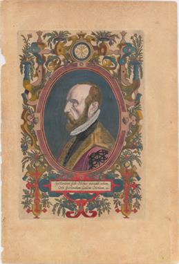
Los 1
Ortelius/Galle, 1579 Spectandum Dedit Ortelius Mortalib. Orbem, Orbi Spectandum Galleus Ortelium This famous portrait of Ortelius, at the age of about 50, was engraved by Philippe Galle and appeared in the Theatrum from 1579 onwards. Few other portraits of the great cartographer have survived. The Latin title translation is, ""By looking, Ortelius gave to mortal beings the world, by looking at his face, Galleus gave them Ortelius."" The portrait is surrounded in a strapwork and garland frame. Latin text on verso. 8.2"" W x 12.7"" H Original color with light toning and a few small chips in far left blank margin.

Los 7
Herrera y Tordesillas, Antonio de 1726 Historia General de los Hechos de los Castellanos en las Islas y Tierra Firme del Mar Oceano... Antonio de Herrera y Tordesillas was the official chronicler of the Spanish possessions in the Indies. His most important work, Historia General , begins with the history of the voyages of Columbus and includes events in America up to 1554, with the suppression of the revolt of Francisco Hernandez Giron in Peru. His work was originally published in 1601 with several editions and translations thereafter, all of which are scarce. This title page is from an early 18th century edition published by Nicolas Rodriguez. The engraving includes the royal coat of arms of Spain and portraits of famous Inca chiefs. At top center is a portrait of the legendary first Sapa Inca of the Kingdom of Cusco, Ayar Manco Capac, with his magic staff. Along the sides are portraits of 12 additional chiefs of the Inca Empire. 6.3"" W x 9.8"" H Minor soiling with a few small abrasions with no loss of image and a tiny hole only visible when held to light. The number ""2"" has been written in manuscript over the engraved number ""6"" in the date.

Los 8
Homann Heirs, 1760 Atlas Mapparum Geographicarum Generalium & Specialium Centum Foliis Compositum et Quotidianis Usibus Accomodatum Accedit Introductio in Geographiam Mathematicam, Naturalem & Historican Inset at the bottom of this handsome title page is a map (5.6 x 4.1"") of a northern hemisphere showing the Island of California. The Latin phrase, Nulla dies abeat, quin linea ducta superfit (Let not a day pass without a drawn line remaining) is on a banner above the map. The hemisphere is surrounded by the sun, moon and stars. Similar to McLaughlin`s state 2, but this unrecorded example was published in the Atlas Mapparum Geographicarum rather than Grosser Atlas Liber die Gantze Welt. 12.4"" W x 19.6"" H Watermarked paper with light soiling and a tear in bottom blank margin that has been closed with archival tape.
![Sylvanus, Bernard 1511 [Untitled - World] ""This rare and distinctive """"modern""&q](http://lot-images.atgmedia.com/SR/36385/2901770/10-201425153635_468x382.jpg)
Los 10
Sylvanus, Bernard 1511 [Untitled - World] ""This rare and distinctive """"modern"""" world map, from the 1511 edition of Ptolemy`s Geograhia, is an extremely early example of 16th century Venetian cartography and one of the earliest maps obtainable by today`s collectors. This Latin edition of Ptolemy was the first published in Venice, by Jacobus Pentius de Leucho, and was the first atlas to use two-color woodblock printing. The maps were printed in black with place names and headings printed in red ink by means of type set into the woodblock and applied with a second strike of the plate. The text was based on a Latin translation by Jacobus Angelus, with revised maps by Bernardus Sylvanus. Little is known of Sylvanus, a native of Southern Italy, although he is believed to have been a monk. Realizing that Ptolemy`s maps were outdated, Sylvanus set out to update them with modern information, often from contemporary manuscript sources. The resulting effect was an unusual hybrid of classical and modern information. Sylvanus also introduced a new world map, depicted for the first time in a distinctive cordiform (heart-shaped) projection, which was adopted by several later cartographers and used for a number of important 16th century maps. This world map was the first to show the newly discovered Americas in an edition of Ptolemy`s Geograhia, and presents a fascinating view of the post-Columbian world. South America, of which only the eastern coast is shown, is named Terra Sanctae Crucis but bears no additional place names. The islands of Cuba and Hispanola appear overly large and surrounded by numerous small, unnamed islands. Further north and quite close to Ireland are the island Terra Laboratorus and a partially delineated region named Regalis Domus, resulting from the Portuguese explorations of the Corte Real brothers in 1501. On the opposite side of the map the island of Zampagv (Japan), which appears for only the second time on a printed map. The first appearance being on the Contarini/Rosselli map of 1506, of which there is only one known copy. The land masses are vigorously engraved with mountain ranges, rivers and place names, and the map is surrounded by decorative wind heads and signs of the zodiac. Printed on two sheets, joined."" 22"" W x 16.3"" H A nice impression with light soiling, about 10 small worm holes (most only visible when held to light), and a couple of small chips along sheet edge at right, far from image. The bottom wind head has been partially cut off, apparently as issued as the to

Los 11
Munster, Sebastian 1553 Das Erst General Inhaltend die Beschreibung und den Circkel des Gantzen Erdtrichs und Mores This famous woodblock map is presented on an oval projection surrounded by clouds and wind heads with the title above the map. The continents are shown in rough outline only. North America is shown with the large cleft nearly separating the east coast from the continent, often referred to as the Sea of Verazano. What appears to be a large Northwest Passage stretches towards Asia. South America has a very strange shape as well. In Africa, the Nile is prominently shown with its twin sources beginning in a range of southern mountains. The mythical islands of Grisonum and Calensuan are placed in the proximity of Australia, where there is also the label Mare Pacificum. A sailing ship and several fierce sea monsters occupy the oceans. Initials of the engraver David Kandel in lower left-hand corner. This is the second `modern` world map to appear in Munster`s Cosmographia, published between 1550 and 1578. This example is from a German edition, which were published between 1550-78, with German text and an elaborate woodblock engraving on verso. 15"" W x 10.9"" H There are expert repairs to a few minor centerfold separations and light toning that is slightly uneven along the centerfold. A small chip in bottom blank margin along centerfold has also been archivally repaired.

Los 14
Quad, Matthias von Kinckelbach 1597 Typus Orbis Terrarum, ad Imitationem Universalis Gerhardi Mercatoris... This is Quad`s version of Mercator`s planispherical map of 1569, with the addition of the figure of Christ in an oval frame in the top left quadrant of the map. The North American continent is shown overly large and South America is depicted with the incorrect bulge on the western coast. Quad also retains the mythical islands of Groclant, Thule, Frischlant, and S. Brandam around Greenland. Large landmasses are shown at both poles, and there is a distinct Northern Passage to Asia. A boldly engraved frame border surrounds the map, containing both the title at top and a quotation from Cicero at bottom. 12.3"" W x 8.6"" H A nice impression with a professionally repaired tear that just enters map border at bottom and a couple of tiny worm holes, only visible when held to light. There are a few small chips confined to the blank margins that have also been professionally rep

Los 18
Hondius/Mariette, 1642 Nova Totius Terrarum Orbis Geographica ac Hydpographica Tabula The Hondius world map of 1617 was the prototype for a series of maps by French publishers who combined Hondius` geographical information with the more scientific border decorations from Boisseau`s map of 1636. The map depicts the discovery of the Le Maire Strait at the tip of South America. In North America, the St. Lawrence River runs nearly the entire width of the continent, terminating in a large lake not far from the infamous Civolo 7 citta (7 cities of Cibola). Hudson Bay is depicted after the work of Gerritsz. In Asia, Korea is shown as an island, the northern coast of New Guinea is more properly located and there is a large Terra Australis Incognita with Boach named in the region of the Australian continent. The surrounding engravings include a pair of celestial charts, circular diagrams containing the compass points, the names of the winds, the climatic zones, the heavenly orbits and a thirty-year calendar. The map is richly adorned with a variety of decorations including three cartouches, two featuring native figures, numerous sailing ships, sea monsters, flying fish and a depiction of Neptune. This is the first state with Mariette`s imprint. Although dated 1642, this was likely published in the 1653 edition of Mariette`s Theatre Geographique de France. 22"" W x 15"" H A fine impression, issued folding and now flattened on watermarked paper with light soiling. There are professional repairs to a small hole at far left as well as a few short separations and tiny holes along the folds. The left and right margins have be

Los 19
Visscher, Nicolas 1658 Orbis Terrarum Nova et Accuratissima Tabula Visscher`s magnificent large map is regarded as the foundation for highly decorative Dutch world maps produced throughout the remainder of the 17th century. The twin hemispheres are surrounded by dramatic scenes drawn by Nicolas Berchem. These superb engravings represent the abduction of Persephone by Hades, Zeus being carried across the heavens in an eagle-drawn chariot, Poseidon commanding his entourage, and Demeter receiving the fruits of the Earth. Inset between the cusps are smaller polar projections, each flanked by allegorical representations of Fire, Air, Water and Earth. Geographically the map is based on Blaeu`s large world map of 1648 with minor variations in the island of California shown here with a flat northern coast, and Anian appearing adjacent to a strait leading within striking distance of the western shores of Hudson Bay. In China, stippling is used for the first time in a general map to denote a desert, Xamo Desertum, just west of the Great Wall. The map appeared in Jansson`s Novus Atlas in 1658 and was used in several later atlases both by Jansson and Visscher, all in this unchanged state. 22.1"" W x 18.4"" H A fine impression with attractive old color, light toning, and a few small spots of foxing. There is an archivally repaired centerfold separation that enters 8.5"" into map at bottom. Remnants of hinge tape on verso.

Los 24
Pitt, Moses 1680 Nova Totius Terrarum Orbis Geographica ac Hydrographica Tabula ""This beautiful map is one of the most intriguing examples of the internal workings of the map publishing business in the seventeenth century. The copperplate from which the map was printed was originally engraved by Pieter van den Keere (Petrus Kaerius) in 1608. It then passed into the hands of Jan Jansson in 1620, and finally to Janssons heirs who formed a partnership with the Englishman, Moses Pitt. The plate was reworked several times and a comparison of the various states provides a compelling view of the changing image of the world during the 17th century. In this final state, the classic carte-a-figures borders remain unchanged, while the map itself was updated with actual discoveries such as Australia, Tierra del Fuego and the straits of Magellan and Le Maire. Other changes reflect prevailing, but erroneous, theories such as an insular California, a peculiar isthmus linking Nova Zemla to northern Asia, and a revived huge Antarctic landmass. The map is very scarce because Pitts ambitious atlas project was a commercial failure, resulting in his confinement in debtors prison. This map is a classic example of the mapmaker`s art with carte-a-figures borders depicting allegorical representations of the sun, moon, the five known planets, the four elements and the four seasons. Along the bottom are vignettes showing the seven wonders of the world: the Hanging Gardens of Babylon, the Colossus over the harbor at Rhodes, the Pyramids, the Mausoleum of Halicarnassus at Cairo, the Temple of Diana, the Statue of Jupiter and the lighthouse at Alexandria. This example has been printed on very wide-margined paper that has been double red-lined ruled just outside of the plate mark, which was a common embellishment for a royal presentation set."" 21"" W x 15.7"" H A nice impression in full original color, printed on an extra-large watermarked sheet. There is light soiling, some minor color offsetting, and a few small abrasions at bottom right of image. There are professional repairs to centerfold separations at t

Los 44
Hondius/Bertius, 1618 La Description des Hyperborees This captivating miniature map of the North Pole is based on Gerard Mercator`s map published in 1595. It depicts the region between the pole and the Arctic Circle with both the North Pole and the magnetic pole shown as rocky islands. The pole is surrounded by `in-drawing seas` between four huge islands. Four scenes of Arctic wildlife fill the corners of the engraving, including a reindeer, fox, walrus, whale, and polar bears. French title page on verso. 4.8"" W x 3.9"" H A fine impression with a light stain at left, some printer`s ink residue in bottom blank margin, and light text show-through.

Los 45
Delisle, Guillaume 1714 Hemisphere Septentrional pour Voir Plus Distinctement les Terres Arctiques This is the first edition of this important map of the Northern Hemisphere, drawn with Delisles characteristic scientific approach. This is the first map to correctly place the west coast of North America, moving it substantially east from previous mapping. California is shown as a peninsula at a time when it was often still shown as an island, even in other maps drawn by Delisle, although a dotted line still hints at the possibility of the island form. Near the northern coast of Asia is Terre de la Compagnie with a note about its discovery by Jean de Gama. Delisle based his depiction of the Northern Pacific on the voyage of Fondant in 1709. 17.8"" W x 17.9"" H On watermarked paper with ample margins. There is light soiling and a few small scattered stains within the map image.

Los 47
Zatta, Antonio 1779 Emisfero Terrestre Settentrionale Tagliato su l`Equatore Based on Robert de Vaugondy`s map, this polar projection covers from the North Pole to the equator. In North America, the mythical Northwest Passage is shown connecting through the Strait of Anian and L. de Fonte to Hudson Bay. The map also includes Lahontans system of rivers and lakes in the west; it labels the river connecting the Mississippi River to the Pacific the Beautiful River. The Arctic discoveries of the eighteenth century are all well depicted. 16.5"" W x 13"" H Original color on watermarked paper with light toning along the centerfold and a few tiny spots of foxing.

Los 49
Hondius/Bertius, 1618 Description de la Terre Soubs-Australe This handsome miniature map is one of the first to focus solely on the South Pole. It depicts a large Magallanica Sive Terra Australis Incognita incorporating Terra del Fuogo, Beach Provincia, Psittacorum Regio, and Promontorium Terrae Australis. The large landmass is separated from South America by the Strait of Magellan, and almost joined to Nova Guinea, with the Salomon Islands depicted nearby. The map is handsomely adorned with a fierce sea monster, a sailing ship, and two compass roses orienting north away from the South Pole. French title page on verso. 5.3"" W x 3.8"" H A nice impression on watermarked paper with minor marginal soiling and light text show-through.

Los 50
Burritt, Elijah H. 1835 Atlas, Designed to Illustrate the Geography of the Heavens, Comprising the Following Maps or Plates. ""Complete celestial atlas with eight charts of the constellations. This popular star atlas was intended for the general public, rather than for professional astronomers. Only the brighter stars and nebulae, and their allegorical forms, are depicted on the charts. The stiff paper covers include a vignette of astronomers using a telescope. Charts include: 1) A Plan of the Solar System Exhibiting its Relative Magnitudes and Distances... 2) The Visible Heavens in January, February, and March. 3) The Visible Heavens in October, November, and December. 4) The Visible Heavens in April, May, and June. 5) The Visible Heavens in July, August, and September. 6) Southern Circumpolar Map for each Month in the Year. 7) Northern Circumpolar Map for each Month in the Year. 8) A Celestial Planisphere, or Map of the Heavens."" 14.3"" W x 16.5"" H This atlas is nearly always found in poor condition, however in this example most of the charts are in B to B+ condition. The charts are in original color with light offsetting and scattered foxing throughout - primarily in the first chart and then quite
![1814 [Untitled - Napoleon Bonaparte Portrait] ""This satirical cartoon depicts Napoleon Bonaparte in a style deriv](http://lot-images.atgmedia.com/SR/36385/2901770/56-201425155049_468x382.jpg)
Los 56
1814 [Untitled - Napoleon Bonaparte Portrait] ""This satirical cartoon depicts Napoleon Bonaparte in a style derived from Giuseppe Arcimboldo, a 16th century Italian artist who is famous for his portraits represented by flowers, fruits and other common objects. In this caricature, Napoleon`s hat is a black eagle, representing Germany, with its talons gripping Napoleon`s head. His face is cleverly composed of corpses, with his collar symbolizing a river of blood. His coat is a map depicting major battle sites in Germany. Napoleon`s medal of the Legion of Honor is replaced with a spider in its web. The coat also features a golden epaulette made from a hand, with the Eye of Providence on the wrist and fingers named for the primary powers engulfed in the Napoleonic Wars against France (England, Russia, Austria, Prussia and Sweden). The hand appears to be tugging on one of the threads of the spider`s web, ready to unravel it, symbolizing the beginning of Napoleon`s demise. This caricature was originally created by the Henschel brothers immediately after the Battle of the Nations at Leipzig to commemorate German victory over Napoleon. The cartoon was first issued as a New Year`s card, often with accompanying text describing each element, and was soon copied in various printed versions all over Europe."" 2.1"" W x 3.7"" H Original color with light scattered foxing.
-
534325 Los(e)/Seite