534325 Preisdatenbank Los(e) gefunden, die Ihrer Suche entsprechen

Verfeinern Sie Ihre Suche

Jahr

Sortieren nach Preisklasse
  • Liste
  • Galerie
  • 534325 Los(e)
    /Seite

Los 727

Blat CLXXIII The recto of this sheet with German text shows an illustration of the monastery of Cluny in addition to the portraits of Arnulf (Arnulphus), the seventh emperor of the Guals, Berno, the abbot of the Cluny monastery, and King Rudolph. The verso depicts portraits of Michael (Michaelis), the archangel, and Popes John (Ioannes) the Ninth, Benedict (Benedictus) the Fourth, Leo the Fifth, Christopher, and Sergius the Third.See also lot 772 for The Making of the Nuremburg Chronicle by Adrian Wilson. Minor toning with light soiling. 16.2"" W x 10.9"" H Schedel, Hartmann 1493

Los 728

Blat CLXXVII The verso of this sheet of German text shows the portraits of Taxis, king of the Hungarians, brothers Spytihnev and Wratislas, Saint Wenceslas, and King Otto. The recto depicts the portraits of King Lothair, King Rudolph, King Berengar IV, and his son, King Albertus.See also lot 772 for The Making of the Nuremburg Chronicle by Adrian Wilson. Attractive color with light soiling. 16.1"" W x 10.9"" H Schedel, Hartmann 1493

Los 729

[Book of Hours Leaf] Superb vellum leaf from this important transitional period when books began to be printed from movable type, decorated with metal-cut illustrations and combined with hand-painted illuminated initials. It is printed on vellum in black and red with many initials hand painted in red, blue and gold. The recto features an illustration of the Adoration of the Magi with all their gifts. Joseph appears in the stable in the background. The text on verso has an ornamental border depicting mythical animals as well as other metal cuts with scenes from the New and Old Testament, with captions in red.Thielman Kerver was a printer in Paris, who worked ""in vico sancti Iacobi ad signum Vnicornis & ibidem venales habent"" (in Saint Jacob`s lane under the sign of the Unicorn where they are also for sale). He began printing Books of Hours in 1497 and continued until his death in 1522. His widow, Iolande Bonhomme, took over the firm, and continued to produce liturgical books until 1556. Kerver`s work is much less common than that of his colleagues, Simon Vostre and the Hardouins. Light toning along fore-edge with marginal soiling. 5.5"" W x 3.6"" H Kerver, Thielman 1505

Los 730

[Book of Hours Leaf] Superb vellum leaf from this important transitional period when books began to be printed from movable type, decorated with metal-cut illustrations and combined with hand-painted illuminated initials. It is printed on vellum in black and red with many initials hand painted in red, blue and gold. The recto features an illustration of the flight into Egypt, in which Joseph flees with Mary and baby Jesus. In the background at top left, an Egyptian statue cracks and falls from atop a building. The text on verso has an ornamental border depicting mythical animals as well as other metal cuts with scenes from the New and Old Testament, with captions in red, including an image of Pilate washing his hands to prove his innocence regarding the execution of Jesus.Thielman Kerver was a printer in Paris, who worked ""in vico sancti Iacobi ad signum Vnicornis & ibidem venales habent"" (in Saint Jacob`s lane under the sign of the Unicorn where they are also for sale). He began printing Books of Hours in 1497 and continued until his death in 1522. His widow, Iolande Bonhomme, took over the firm, and continued to produce liturgical books until 1556. Kerver`s work is much less common than that of his colleagues, Simon Vostre and the Hardouins. Light toning along fore-edge with marginal soiling. 5.6"" W x 3.7"" H Kerver, Thielman 1505

Los 731

[Book of Hours Leaf] Superb vellum leaf from this important transitional period when books began to be printed from movable type, decorated with metal-cut illustrations and combined with hand-painted illuminated initials. It is printed on vellum in black and red with many initials hand painted in red, blue and gold. The ornamental border depicts scenes from the Old and New Testaments with captions in red, as well as some mythical animals. On the recto are images of the temptation of Jesus by the devil (Matthew 4:1-11) and of Adam and Eve in the Garden of Eden with a serpent with a human head. On verso is an image of the resurrection of Lazarus (John 11:1-46).Thielman Kerver was a printer in Paris, who worked ""in vico sancti Iacobi ad signum Vnicornis & ibidem venales habent"" (in Saint Jacob`s lane under the sign of the Unicorn where they are also for sale). He began printing Books of Hours in 1497 and continued until his death in 1522. His widow, Iolande Bonhomme, took over the firm, and continued to produce liturgical books until 1556. Kerver`s work is much less common than that of his colleagues, Simon Vostre and the Hardouins. Light soiling and toning. 5.6"" W x 3.6"" H Kerver, Thielman 1505

Los 733

[Antiphonal Leaf] A large vellum leaf from an antiphonary. Both sides with seven staves of five-line music, written in black and red ink. The thin sheet of vellum includes a large initial on each side that is decorated in filigree pen work. One small stain adjacent to the large initial ""B"" with light soiling and some creasing in bottom blank margin. There are a few tiny worm holes in blank margins. 16.7"" W x 12.3"" H Anon., 1700

Los 734

[Vellum Manuscript Indenture] This vellum indenture serves as testament to a one-year lease of a ""messauage, burgage or tenement"" in the amount of five shillings, signed February 10, 1672. The lease is between Francis Holden and William Boardman from Witton in the county of Lancaster. The indenture includes a large red wax seal.The top of the indenture is cut in a jagged (""toothed"") line, as was the common practice with indentures. The legal contract was duplicated on a single sheet, and then the copies were separated by a jagged edge, so that the two pieces could be fit together again to verify authenticity. Nice sheet of vellum with light soiling and a few small abrasions. 14.8"" W x 27.8"" H 1672

Los 737

La Geografia di Claudio Tolomeo Alessandrino, Nuovamente Tradotta di Greco in Italiano... This is the first edition of Girolamo Ruscelli`s translation of Claudius Ptolemy`s Geographia, published in Italian. It was printed by Vincenzo Valgrisi in Venice, with the text translated from Greek by Ruscelli. It is complete with 62 maps; 25 classic and 37 modern, which are enlarged copies of the maps created by Giacomo Gastaldi for his 1548 edition of Ptolemy. These maps demonstrate the amazing advances in geographic knowledge taking place in this great era of exploration. They are from finely engraved copper plates, which were a great improvement over the rather crude woodcut maps in many of the earlier editions. The maps were engraved two to a plate, then printed and separated for binding, which is why the plate mark for each map runs off the top edge of the page. The classic maps include a conical projection of the world, 10 maps of Europe, 4 of Africa, and 12 of Asia. The modern maps include two world maps, 17 maps of Europe, 5 of Africa, 6 of Asia, and 7 maps of the Americas.Orbis Descriptio is the first double-hemisphere world map to appear in atlas form. It is elegantly engraved in the characteristic Italian style, adapted from the oval projection used by Gastaldi, and presented on what is known as Roger Bacon`s circular projection. This projection was popularized by Ruscelli and later by Rumold Mercator. Another important feature of the map is the apocryphal bulge in South America; one of the most copied cartographic errors of the 16th century. Terra Incognita is distinctly shown as a land bridge linking Asia and North America with its coastline labeled Littus incognitum. This is the first state with no southern continent.Ruscelli`s important early map devoted to the East Coast of North America, Tierra Nueva, is based on Giacomo Gastaldi`s map of 1548, which combined data from the Verrazano and Cartier voyages. The cartography is unchanged, with the exception of the depiction of the Hudson and St. Lawrence Rivers (unnamed), which are shown connected upriver, a notion he borrowed from Ramusio. Engraved on copper by Giulio and Livio Sanuto in the unmistakable Italian style.Also included is Nueva Hispania Tabula Nova, a foundation map in the cartography of the American Southwest, and a must for collectors of that region. It is an enlarged version of Gastaldi`s map of 1548 with the only notable change being the peninsular Yucatan. The legendary seven cities of Ciuola are prominently depicted and Mexico City is shown floating in a large lake. The place names along the upper Gulf Coast reveal the explorations of Pineda, Cabeza de Vaca and Moscosso. The Mississippi makes its appearance as the Rio de Spiritu Santo and the R. Tontonteanc flows in the vicinity of the Colorado River.Complete, 358 pages, 62 maps, and index. Bound with the 47-page Discorso Universale de M. Gioseppe Moleto Matematico.... Original vellum binding with brown ink manuscript title on spine. The text and maps are bright with light foxing and a faint damp stain at top right, entering up to 1"" into some maps. Most of the maps are in very good to near fine condition, with a few only in good condition. The first 40 pages of text also have a damp stain along the spine. There are some manuscript notations and a previous owner`s stamp on the title page. The hinges are starting and the covers show some wear with a few small worm tracks. 9.3"" W x 6.4"" H Ptolemy/Ruscelli & Valgrisi, 1561

Los 740

Atlas Contenant Vingt-Sept Cartes Geographiques, pour Servir a l`Histoire Ancienne et Romaine This complete historical atlas contains 27 maps (10 folding), consisting of 13 maps of the ancient world and 14 maps of the Roman Empire. The maps depict the ancient world, Greece, Italy, France, Spain, northern Africa, Arabia and the Middle East. Included are two attractive plans of Syracuse, a plan of Ancient Rome, and maps showing the marches of Alexander the Great and Hannibal. Several of the maps have decorative title cartouches and were produced by d`Anville dated between 1738-1741. Original quarter-leather binding with marbled-paper covered boards. The maps are clean and bright with faint to light offsetting. Covers are moderately worn with bumped edges. 12.3"" W x 9.4"" H Rollin/Bastien, 1807

Los 744

Improved Atlas, for the Revised Edition of Adams` Geography This uncommon school atlas contains two double-page and ten single-page maps. Each is well detailed and shows topography, rivers and settlements. The double-page map of the United States features an independent Republic of Texas in an unusual rectangular representation. To the north of Texas are the large Indian, Missouri, Iowa and Wisconsin territories. Seven of the maps relate to the United States along with maps of South America, Europe, Asia, Africa, and the British Isles. Engraved by H. Morse. The maps are good to very good with light scattered foxing and faint offsetting. The map of the British Isles has a 1.5"" edge tear at left that has been closed on verso with archival tape. Covers are lightly soiled and the spine has been reinforced. 8.6"" W x 6.8"" H 1838

Los 745

Morse`s General Atlas of the World. Containing Seventy Maps, Drawn and Engraved from the Latest and Best Authorities This complete atlas contains 70 cerographic maps on 66 sheets with approximately half of the maps focused on the United States. The maps of North America and the United States feature large Utah, New Mexico and Nebraska territories, with Oregon and Washington Territory extending to the Continental Divide. The map of Texas shows county development confined to the eastern half of the state, with Presido, El Paso, and a large, unnamed Staked Plain occupying the west. The map of Florida shows the extent of surveying confined north of Tampa. Several of the state maps employ red overprinting to identify counties, roads, and railroads (presumably to be the most up-to-date at the time of printing). Outside of the United States, there is a fascinating Chart Showing the Recent Search for a North-West Passage which depicts the extensive effort in locating John Franklin, who searched for a Northwest Passage in 1845 and disappeared in 1847. Decorated by an elegant frontispiece featuring an explorer and vignettes from around the world. Elephant folio, rebound with new maroon cloth over original tan cloth boards with gilt title on front cover and marbled endpapers. Maps are very good to near fine with light toning and occasional offsetting from opposing text. There is light scattered foxing on frontispiece, title page, and text. Previous owners` stamp and bookplate appear on title page. Spine still appears new and original cloth boards are moderately soiled and stained. 17.2"" W x 14.1"" H Morse, Charles W. 1856

Los 746

Colton`s General Atlas, Containing One Hundred and Seventy Steel Plate Maps and Plans, on One Hundred Imperial Folio Sheets... Colton`s massive single-volume General Atlas, is considered by many to be the pinnacle of American cartography in the latter part of the 19th Century. There are 89 single-page and 6 (out of 7 - missing New York State) double-page maps in all, including many highly sought-after state and regional maps. It includes the desirable Territories of New Mexico and Utah depicting the region with the largest configurations of the Utah and New Mexico territories. Other important state maps featured in this atlas are the double-page editions of Kansas and Nebraska, which shows little development in the western reaches of each state; Washington & Oregon, which shows Washington Territory encompassing the region that would become Idaho; and nice maps of Texas and California. The atlas also features several thematic maps including Mountains and Rivers and Comparative Size of Lakes and Islands. A pair of fine city plans are the single-page, uncolored Environs of London and Environs of Paris. The frontispiece features four beautiful muses gathered around the globe in a classical allegorical engraving. This is a beautiful example of a rarely offered atlas by one of America`s pre-eminent cartographers. The atlas is nearly complete with only the map of the state of New York missing. The volume includes a frontispiece, title page, list of maps, text and maps. Folio. Hardbound in original quarter calf with tips over green cloth with decorative gilt titling on front and spine. Marbled edges. The maps have bold original color and range in condition from near fine to good, with light toning, occasional spots of foxing, and faint offsetting. The double-page world map has a centerfold separation at bottom. The binding is sound, the covers are moderately worn and stained, and the spine is worn and torn at top and bottom. 18"" W x 15.5"" H Johnson & Browning, 1859

Los 747

Mitchell`s New General Atlas, Containing Maps of the Various Countries of the World, Plans of Cities, etc. Embraced in Fifty Quarto Maps, Forming a Series of Eighty Maps and Plans, Together with Valuable Statistical Tables This complete example of Mitchell`s world atlas was produced during the second year of the Civil War. It is complete with 80 maps and plans on 50 sheets, each surrounded by Mitchell`s signature floral border. There are 25 map sheets related to the United States including 34 individual states and territories, regions and city plans. There are two world maps - one hemispheric and the other drawn on Mercator`s Projection.The map of Texas shows county development to 100° longitude with the large regions of El Paso, Presidio and Bexar Territory further west. The Staked Plain is now called Young Territory. The map of the United States depicts the Confederate Territory of Arizona, Nebraska with a long panhandle, and Washington Territory in its inverted ""L"" shape. The Pony Express route is depicted as are numerous exploration routes, important trails including the Santa Fe, the Overland Mail Route to California, wagon roads and early railroads. This 1862 edition did not include a separate map of the southwest, however on the U.S. map the southern tip of Nevada is contained as part of New Mexico Territory, and Utah encroaches a full degree into Nevada. Includes full-page plans of the cities of Boston, New York, Philadelphia, Baltimore, Washington DC, New Orleans and Cincinnati. All maps carry the 1860 copyright date. Hardbound small folio, publisher`s quarter calf with tips over cloth covered boards, stamped title on front cover. Title page, list of maps, and maps and plans are followed by 26 pages of text: List of Post Offices in the United States, Table of Population, Governments. &C., Mountains of the World, and Rivers of the World. Condition code is for the maps which are generally very good with light toning and scattered foxing. The map of Ohio/Indiana has separated from the text block and chipped along the edges of the sheet. The title page and list of maps have large damp stains. Front cover is separated and the text block is loose. Covers and spine are moderately worn with a few damp stains on the back cover. 16"" W x 13"" H Mitchell, Samuel Augustus 1862

Los 748

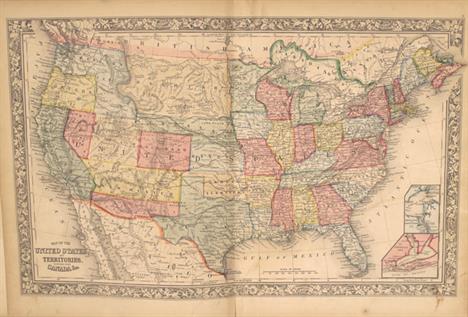
Johnson`s New Illustrated Family Atlas, with Physical Geography, and with Descriptions Geographical, Statistical, and Historical... This complete atlas contains 55 beautifully rendered maps, including 47 double-page maps. There are several thematic maps and diagrams interspersed throughout the text that display the geology, weather, tides, agriculture, flags and animal kingdoms of the world. The steel-engraved frontispiece is a lovely view of the US Capitol. This atlas also features the double-page Civil War map Vicinity of Richmond.This edition includes the Southwest map depicting the original four counties of Yavapai, Mohave, Yuma, and Pima in the newly organized Arizona Territory, with Prescott as the capital. The Utah/Nevada border is now at 114° and Arizona and Nevada have their final borders. Early historical details include the Pony Express and United States Mail routes, the emigrant roads to California, and the proposed southern railroad route.The double-page map of Texas shows county development mostly in eastern Texas and only the four large counties of Young, El Paso, Presidio and Bexar in the west. The panhandle, noted as the Staked Plains Â… without Wood or Water, includes a large section that is unorganized. There is nice depiction of the wagon roads, many named, with several completed railroads. The inset maps are `Northern part of Texas` and `Plan of Galveston Bay.` The double-page map of `Nebraska, Dakota, Idaho and Montana` shows a very early rendering of Wyoming Territory, organized in 1868. Idaho is shown taking up the present-day Wyoming region south of Jackson Hole. With the exception of the southwestern border, Montana is correctly formed which, along with Wyoming, was previously contained in a large Idaho territory. Dakota Territory, from which Wyoming was formed, remains undivided. There is excellent detail throughout with scores of place names, roads, watershed, topography, the Emigrant Road, forts, springs, routes of exploration and proposed railroads. The route of the Pony Express & U.S. Mail Route through Utah, Wyoming and Nebraska is delineated.Folio. 137 pp., frontispiece, 55 maps, and 5 charts depicting mountains and rivers of the world, flags, universal time, and coats of arms. Hardbound in original quarter leather with tips and green cloth, embossed covers with gilt titles on cover and spine, marbled pastedowns. The maps are all in very good to near fine condition with bright original color, light toning around sheet edges, occasional spots of foxing, and minor offsetting on a few maps. Four double-page maps have long centerfold separations that have been closed on verso with archival tape, and the map of New York State has a 4"" tear along the centerfold that has also been closed on verso with archival tape. The binding is sound. The front and back free-endpapers have been removed, and the last page in the atlas is partially detached. The covers and spine show moderate wear. 18.6"" W x 14.8"" H Johnson, A. J. 1867

Los 749

[Lot of 2] Mitchell`s Modern Atlas... [and] Mitchell`s Ancient Atlas, Classical and Sacred... A. Mitchell`s Modern Atlas: A Series of Forty-Four Copperplate Maps, Compiled from the Great Atlases..., published 1875. This world atlas contains 15 maps of US interest including the United States and ""XIII Texas."" The 44 maps are hand colored and printed on both sides. Hardbound with pictorial paper over boards featuring children on a hillside overlooking a small sea village with erupting volcano. Condition: Overall light toning and soiling with the United States map severed in half. Several other maps in the first third of the atlas have short fold separations at bottom. The front cover is detached which has the endpapers and title page attached along the hinge with paper tape. Covers heavily worn and soiled. (C+) B. Mitchell`s Ancient Atlas, Classical and Sacred, Containing Maps Illustrating the Geography of the Ancient World, as Described by the Writers of Antiquity..., published 1867. Contains 12 maps on six sheets including a double-page map of the Roman Empire. Other maps include Ancient Italy, Ancient Greece and Asia Minor. Includes a 12-page index. Condition: Generally good to very good with light toning. The map of the Roman Empire has a 2"" fold separation at bottom and two other sheets have 1.5"" edge tears at bottom. Covers are rubbed with a few small stains and are nearly detached. (B) See description 11.8"" W x 9.6"" H Mitchell, Samuel Augustus 1867-75

Los 751

Tunison`s Peerless Universal Atlas of the World This is a lovely and unusual atlas complete with over 80 wax engraved, hand colored maps and diagrams, most with decorative borders and some with vignettes. Nearly half of the maps relate to the United States. Most of the maps are printed on both sides. The map of California, Oregon, and Nevada is particularly nice with insets of Yosemite and the Redwoods. Also featured are two pages of presidential portraits and numerous engravings showing the diverse civilizations and cultures of the world. The last map is ""Map of the Regions about the Unknown North Polar Sea Showing the Latest Exploring Expeditions."" These maps are uncommon for their late hand coloring, a laborious process that was largely abandoned two decades earlier. Small folio, 208 pp. Hardbound in original, embossed brown cloth boards. A very lovely example of this increasingly difficult to find atlas. Maps are very good to near fine with light pleasant toning. Title page has minor soiling and foxing mostly in the blank margins. Hinges are starting with an amateur repair on the inside front cover, and the covers are moderately worn with a few abrasions on the back cover. 14.4"" W x 12.1"" H Tunison, H. C. 1887

Los 753

The Home Knowledge Atlas. Geographical, Astronomical, Historical. Showing the Greatest Number of Maps of Any Atlas Published in the World... Nice late 19th century atlas with maps by George F. Cram and matching the format of his Unrivaled Atlas. The title pages boasts ""Showing the greatest number of Maps of any Atlas published in the World."" 409 pp., over 200 printed color maps including Canada and its provinces, the U.S. and each separate state, scores of city plans, countries of the world and a few historical maps. There is also an extensive section on astronomy and celestial maps. Maps printed on both sides. Original, embossed cloth binding with gilt lettering. Marbled end papers. This is the Canadian issue published from Toronto. Condition code is for the maps, which are very clean and bright, with an occasional spot and light toning along sheet edges, just entering the image on a few maps. There is a light damp stain at bottom right through pages 95-199, also entering the image on just a few maps. The maps are quite loose - barely held together by a string. The front and back covers are detached and soiled and the spine is perished. This should be considered a collection of maps. 13.9"" W x 11.5"" H Cram, George F. & Company 1891

Los 754

The Universal Gazetteer; Being a Concise Description, Alphabetically Arranged... This small geography book contains 14 folding maps including the World, North America, South America, Africa, Asia, Europe, the West Indies and several European countries. In North America, place names are limited to the east coast with East and West Florida depicted. Quivira is located in the west as is a long River of the West with two possible routes shown flowing into the Pacific. The world map shows Tasmania still connected to the Australian mainland and Cook`s tracks are shown in the southern Pacific Ocean. Includes around 400 pages of unpaginated text describing thousands of places ""not to be met with in any similar gazetteer."" Third edition updated by Arthur Kershaw. Hardbound with original leather covers and new faux leather spine. Most of the maps are very good with light toning, an occasional spot of foxing, and faint offsetting. The maps of the World, North America, and South America are in good condition with light offsetting and moderate foxing. The maps of North and South America are separated from the text. Covers are rubbed with a few small abrasions. 8.8"" W x 5.5"" H Walker, John 1801

Los 755

J.H. Colton`s American School Quarto GeographyÂ… Large quarto format school atlas with numerous steel plate maps, profiles and plans on 42 large sheets. Includes a nice map of the United States and the West showing the newly formed Nevada and Arizona, with Dakota Territory occupying the region of present-day Wyoming. As a Civil War-period atlas it is fascinating to find not a single reference to the conflict. 118 pp., hardbound in pictorial paper covers over boards. Published by Ivison, Phinney, Blakeman & Co. in New York. The maps are very good with light toning and an edge tear on the Georgia/Alabama/Florida map closed on verso with cello tape. Covers are rubbed, soiled, and nearly detached. Spine has perished. 13.8"" W x 11.9"" H Colton, George Woolworth 1865

Los 756

Report from the Commissioner of the General Land Office, showing the Operations of that Office since the 17th December, 1838 This report contains eleven early maps by the General Land Office. Each map is drawn on the scale of 18 miles per inch and all are hand colored. A. Sketch of the Public Surveys in the North Part of Michigan (13 x 21.5""). By W.J. Stone this map locates Grand Traverse Bay, Saginaw Bay, Mackinaw Island and shows good watershed detail north from the Kalamazoo River. Condition: There is a binding tear confined to blank space at right, some toning in the top margin, and a small hole at a fold intersection. (B+) B. Sketch of the Public Surveys in Iowa Territory (7 x 11""). By W.J. Stone this map is centered on Iowa City and locates Salem, Bloomfield, Eldford, Davenport, etc. Good watershed detail and the townships are colored to indicate the progress of surveys. Condition: Light toning in the top blank margin. (A) C. Sketch of the Public Surveys in Wisconsin (12 x 11""). Extends from Prairie du Chien to Green Bay and also to show part of the valley of the Wisconsin River where Grigon`s Trading & Farming Establishment, several mills including Conant`s, and Whitneys, and Yellow Banks and Plover Portage are identified. Locates the lands of the Stockbridge and Oneida Indians. Condition: Light toning and scattered foxing. (B) D. Diagram of the State of Illinois (12 x 21.5""). Shows the entire state with townships hand colored to indicate the progress of surveys. Major towns are located. Condition: Light toning with a binding trim confined to blank space at left. (B+) E. Diagram of the State of Missouri, 1839 (22 x 18""). Shows the entire state with townships hand colored to indicate the progress of surveys, which is in very early stage. Major towns are located. Condition: Light scattered foxing mostly in the blank margins. (B+) F. Arkansas, 1839 (17 x 17""). Very nicely color using a wider pallet than normally seen in early GLO maps. Great detail of watershed and towns and settlements in the state. The region in the southwest is Disputed Territory. Condition: Light scattered foxing mostly in the blank margins. (B+) G. [Four maps of Louisiana] Map of the South Western District (10 x 13""); South Eastern District (11 x 8""); Map of the District North of Red River (9 x 8.5""); and St. Helena District (8 x 5""). Each township is noted and the hand colored one indicate the progress of surveys. Condition: Light toning mostly in blank margins and a few spots of foxing. (B+) H. A Plat Exhibiting the State of the Survey in the Territory of Florida (22.5 x 11""). This early, interesting map shows the status of public land surveys in the Eastern and Western Land Districts of the Florida Panhandle. Red outlines the boundary of the Forbes Purchase. St. Augustine, Amelia Island, and Tallahassee are named. An area outlined in red is designated ""Supposed Indian Boundary Line"" while the legend indicates that red outlining is used to indicate proposed new survey areas. Survey efforts in south Florida continue to be hampered by the guerilla warfare of the Second Seminole War (1837-1842). From the Surveyors Office in Tallahassee by Robert Butler Survey General Territory of Florida. Condition: Toning in top and bottom margin with some faint offsetting. (B) Text pages are good with scattered foxing. Maps are good to very good. See individual descriptions above for condition codes. 9"" W x 5.5"" H General Land Office, 1839

Los 757

[Volume IV] Narrative of the United States Exploring Expedition. During the Years 1838, 1839, 1840, 1841, 1842 This was one of the most important American scientific expeditions of the 19th century. It was the first U.S. Naval expedition, taking in the Northwest Coast, Hawaii, South America, the Philippines, the South Pacific, Australia and Antarctica. The expedition broke new ground in most areas of natural history, made a number of extremely important cartographic discoveries, and most importantly established that Antarctica was a continent. They mapped 280 islands in the Pacific for the first time and included extensive and graphically rich ethnographic records of many native peoples throughout the Pacific. This volume`s first 260 pages covers the Hawaiian Islands in great detail with numerous plates (14 of 15) and illustrations interspersed within the text. Of primary interest is the"" Map of the Hawaiian Group or Sandwich Islands"" (11.2 x 8.3"") which serves as the frontispiece for the book. This map is a marked improvement over previous maps of Hawaii. The coast lines of Maui and Oahu are more accurate (despite a few flaws) and Wilkes managed to convey a vivid image of the mountainous terrain. The remainder of the book covers the Expedition`s travels in Oregon and Washington. Octavo, 539 pp. hardbound in original embossed brown cloth covers with gilt embossing on cover and spine. The map is good with offsetting, text is mostly clean with light toning, and the plates have scattered foxing mostly in blank areas. The original covers have typical wear and the spine has been professionally replaced utilizing a portion of the original. 11.5"" W x 7.5"" H Wilkes, Charles 1845

Los 758

Sketches Accompanying the Annual Report of the Superintendent of the United States Coast Survey This is the attractive map edition that accompanies the Coast Survey report for 1851. It includes 56 of the 58 maps called for in the list of contents. Some of the more desirable charts include: Sketch D, No. 5. Preliminary Sketch of Beaufort HarborSketch E, No. 3. Showing the Progress of the Survey at North and South Edisto Rivers and St. Helena Sound Sketch H, No. 10. Preliminary Sketch of Mobile BaySketch I, No.2. Preliminary Sketch of Galveston BaySketch J, No.2. Mare Island StraitsSketch J, No. 6. San Francisco BaySketch K. Mouth of the Columbia River and Cape HancockMissing maps are Preliminary Sketch of Hatteras Shoals and Sketch K, No 2. Mouth of the Columbia River. Contains a list of contents, and 56 small and large folding maps. Hardbound in original embossed brown cloth boards with gilt title on front cover. 8vo. The maps are generally good with light to occasionally moderate toning and offsetting. The bottom third of the Sandy Hook map is nearly separated and the three ""Reconnoissance of the Western Coast"" maps and the Key West map each have a long centerfold separation spanning the map image. The covers are rubbed, the spine has nearly perished, and the front cover is starting to detach. 9"" W x 6"" H U.S. Coast Survey, 1851

Los 759

[Maps and Views] Message from the President of the United States to the Two Houses of CongressÂ…Part III This is the volume of illustrations accompanying the reports submitted for the 2nd session of the 33rd Congress. The 42 illustrations include 6 of 8 state survey maps (missing Iowa and California) to accompany the Report of the Commissioner of the General Land Office, 4 plans to accompany the Report of the Commissioner of the Public Buildings, 1 plan to accompany the Report on the National Hospital for the Insane and 30 of 31 plans and charts of bays and harbors to accompany the Report of the Colonel of Topographical Engineers (missing Ashtabula Harbor, Ohio). Of particular interest are the Topographical Map of a Portion of the Isthmus of Darien, in site of Proposed Inter-Oceanic Navigation and Plat Exhibiting the State of Surveys in Florida. See images for the full listing of maps. Hardbound in original embossed cloth boards with gilt titles on front cover and spine. Maps are generally good to very good with light toning, scattered foxing and occasional faint offsetting which is more prevalent in the first quarter of the report. The map of Kansas/Nebraska and the Harbor of Black River have long fold separations. Covers are lightly rubbed with a chip at the top of the spine, and the back cover is partially detached. 12"" W x 9"" H U.S. Government, 1854

Los 760

Report of the Superintendent of the United States Coast Survey, Showing the Progress of the Survey during the Year 1867 Very nice example of this publication detailing the progress of the Coast Survey in the year 1867. Contains numerous individual reports including a 142-page section on the Resources and Coast Features of Alaska Territory, a section on the resurvey of Galveston Bar and Harbor, Texas, and the obituary of Alexander Dallas Bache. Maps include Boston Harbor; New York entrance; Greenwich Bay, RI; Port of Newbern, NC; Straits of Florida; Galveston entrance; Tillamook Bay, OR; Puget Sound; Alaska; Sitka Harbor; and St. Paul, Kodiak Island to name a few. The four Alaska charts are among the earliest U.S. maps of Alaska following the purchase from Russia in 1867. Hardbound in brown cloth, 334 pp. with 27 maps and sketches. Maps are very good with some light toning along the folds, occasional faint offsetting, and a few spots of foxing. There are library stamps on the versos of most maps and Stanford library/Branner Geological library bookplates on the inside front cover marked withdrawn. Covers and spine are excellent with minimal shelf wear. 11.7"" W x 9.3"" H U.S. Coast Survey, 1869

Los 764

The Southeast in Early Maps with an Annotated Check List of Printed and Manuscript Regional and Local Maps of Southeastern North America During the Colonial Period The definitive cartographic reference for maps of the Colonial Southeast. It is a comprehensive study of the historical cartography of the southeast region of the North American continent before the American Revolution. With an annotated checklist of printed and manuscript regional and local maps detailing 450 maps issued between 1507 and 1773. University of North Carolina Press, 1962. 284 pages. Contains 67 illustrations, descriptions of maps, a chronological title list of maps, an index, and a supplement with additional maps. Light tan cloth covered boards with gilt lettering on the spine. No dust jacket. Like new. 11.3"" W x 8.8"" H Cumming, William P. 1962

Los 773

The Mapping of America A significant reference book that presents a detailed, analytic history of the mapping of North America, emphasizing the area that comprises the United States. Two major periods are covered; the first extending from 1500 to 1800 and the second from 1800 to the present. Illustrated with 223 plates, 84 in full color, 363 pp., index. Hardbound in white cloth with illustrated dust jacket (11.8 x 11""). An often quoted reference work. The text is clean and bright with light soiling along the fore-edges. The hinges are starting and the covers are lightly soiled. 10.9"" W x 11.9"" H Schwartz & Ehrenberg, 1980

Los 4

Nauwkeurige Beschryving der Aard-Gewassen, door Abraham Munting A beautiful example of the title page from the 1696 enlarged edition of Munting`s Nauwkeurige Beschryving Der Aard-Gewassen, a superbly illustrated botanical book of this period. The exquisite plate was drawn by J. Goeree (1670-1731) and published in Leiden by Pieter van der Aa and Francois Halma. The busy scene depicts an offering of fruit and plants to the gods with the assistance of cherubs. Below the ornately framed title are two cherubs with an open copy of the book. Surrounded by a very detailed and finely engraved border filled with fruits and vegetables, along with four classical figures. A stunning example in gorgeous recent color with one small spot in the title. Light toning along the edges of the sheet at right and top. 13.9"" W x 9.3"" H 1696

Los 5

Atlas Novus sive Tabulae Geographicae Totius Orbis Faciem, Partes, Imperia, Regna et Provincias... This bold title page centers on a large globe positioned on the eastern hemisphere that supports the allegorical figure of Europa, with Asia, Africa and America seated beside the globe. Surrounding the title are the mythical figures of Mercury, Minerva and Mars, each holding a map. In the background, Neptune floats in the sea, while putti fly overhead holding a torch and a dove, symbolizing the conflicting nature of war and peace. Original color with several light damp stains and a small abrasion on Mars` arm. Two chips in the right blank margin have been repaired with old paper, with a minor amount of the neatline replaced in facsimile. 19.6"" W x 11.4"" H Seutter, Matthias 1728

Los 6

[Lot of 4] Amerique [and] Afrique [and] Asie [and] Europe Each map from this matching set of continents is flanked by panels of French text describing the continent. The maps and text are surrounded in beautifully engraved rococo borders, printed from a separate plate. Overall dimensions given; maps each measure approximately 9.5 x 11"". Louis Charles Desnos (1725-1805) was an important instrument, globe and map maker in Paris during the eighteenth century. In addition to his publishing work aimed at the French market, Desnos also held the position of Royal Globe maker to the King of Denmark. He worked with several other publishers including Zannoni and Louis Brion de la Tour and produced a great many cartographic works including numerous atlases and a series of decorative wall maps.A. Amerique. Interesting map of the Americas with the northwest coast of North America extremely truncated. The British colonies are confined to the eastern seaboard, France controls most of the interior, and Spain possesses Mexico and the West Coast. South America shows Portugal in possession of Brazil, France controlling Guiana and Spain in possession of the rest of the continent. Sparse interior details.B. Afrique. This map of Africa gives minimal interior detail, with the exception of a few rivers, lakes and mountain ranges. The source of the Nile is shown as twin lakes in the Mts. De la Lune (Mountains of the Moon), well north of the Equator.C. Asie. Numerous areas within the Asian continent are still misshapen, including a very narrow Kamchatka, an oversized Hokkaido, and a large bay depicted in the Indochina Peninsula. New Guinea is depicted attached to an oddly shaped Australia, which is simply labeled as Partie du Continent Inconnu.D. Europe. Although only a few rivers, mountains and place names are shown in the interior of the continent, the boundaries highlight the political situation in Europe during the late 18th century. The German Empire encompasses most of central Europe, extending south to the Adriatic Sea and east nearly to the Black Sea. Poland includes much of the Baltic states and extends south through much of the Ukraine. Finland is divided between Russia and Sweden, and the Turkish Empire includes the majority of the Balkans and wraps to the northern shore of the Black Sea. Original color on watermarked paper with light soiling. 14.3"" W x 20.8"" H Desnos, Louis Charles 1770

Los 10

Typus Orbis Terrarum Charming miniature world map on an oval projection, based on Ortelius. The large, mythical continent of Terra Australis fills the southern portion of the map, incorporating New Guinea. There are just a few place names noted in the map, including Anian, Tolm, Norumbega, Virginia and Florida. The map is similar to the one Bertius supplied for Barent Langenes` Caert-Thresoor except this plate does not contain the signature of Jodocus Hondius as the engraver. Strapwork designs fill the corners with the title above and the quote from Psalms, ""Domini Est Terra Et Plenitudo Eius"" (the earth is the Lord`s and the fullness thereof) at bottom. Latin text on verso. A nice impression with attractive color and light overall toning. 3.8"" W x 5.3"" H Hondius/Bertius, 1618

Los 22

Typus Orbis Terrarum Charming small double-hemisphere map with the peninsular form for California and a huge Terra Australis Incognita. The corners are decorated with the female representations of the four continents. Tucked between the cusp at bottom is the figure of Atlas holding the world on his shoulders, surrounded by wind heads and fire. A fine impression with attractive color on watermarked paper with very light toning. Issued folding. 6.3"" W x 11.9"" H Cluver, Philipp 1729

Los 24

Essay d`une Carte Reduite, Contenant les Parties Connuees du Globe Terrestre... This very large and attractive world chart is drawn on Mercator`s projection. North America is shown with a prominent River of the West connecting through a series of rivers and lakes from Lake Superior to the Pacific - representing the elusive search for a Northwest Passage. The Russian discoveries in the North Pacific are shown with Alaska depicted as an island named I. Unamak. Australia is labeled Nouvelle Hollande with Terre de Diemen still linked to the mainland. New Zealand is fully formed showing both islands and there are numerous islands in the Pacific. The large, decorative title cartouche and two fine compass roses with rhumb lines make this a very attractive chart. Australia and New Zealand reflect the discoveries of Capt. Cook, but Tasmania is still attached to Australia, suggesting a publish date after 1770. Issued folding on watermarked paper with light offsetting, a few small spots, and some short fold separations and edge tears that have been archivally repaired. The sheet has been remargined with old paper at left. 20"" W x 27.9"" H Bellin, Jacques Nicolas 1748

Los 28

[On 4 Sheets] Tabula Itineraria ex Illustri Peutingerorum BibliothecaÂ…Nobilissimo Viro Marco Velsero... These four sheets are Ortelius` scarce version of the famous Peutinger Table. These decorative maps, in a sequence of four plates, each with two strip maps, depict the imperial roads and posts within the Roman Empire throughout Europe, North Africa and Asia as far as Toprobana (Sri Lanka). The format distorts the landmasses, but provides an excellent view of the cities and roads, which include distances between the posts. The three most important cities of the Roman Empire, Rome, Constantinople and Antioch, are represented by enlarged symbols including the emperor seated on a throne. Size given is for each plate. The original parchment document for this incredible map is thought to have been made in the thirteenth century. The original now resides in the Vienna National Library, but is so damaged that the Ortelius version is now the most reliable representation. The Peutinger Table, as it is generally known, derived its name from Konrad Peutinger, who once owned the original. Ortelius had manuscript copies made in 1598 from the original scroll and supervised the engraving, but did not live to see their publication. This is the Parergon edition with Latin text on verso, printed by Balthasar Moretus and published in 1624. Clean and bright examples with nice impressions. The fourth sheet has a tiny hole in the 7th segment caused by a paper flaw, which is only visible when held to light and has been professionally reinforced on verso. 16.2"" W x 20.3"" H Ortelius, Abraham 1598

Los 29

Universalis Tabula Iuxta Ptolemaeum This decorative map of the ancient world is the revised second state of Mercator`s 1578 Ptolemaic world map. The border was re-engraved, surrounded by allegorical figures representing the four elements of Fire (Zeus), Air (Hera), Water (Neptune), and Earth (Gaia), rather than the strapwork and wind head border of the earlier edition. There is a very large Taprobana (modern day Sri Lanka) in the Indian Ocean and the Indian subcontinent is severely truncated, though the Ganges is noted. Only the northern part of Africa is shown with the Nile originating in the twin lakes south of the Equator in the Lunae montes (Mountains of the Moon). A fine impression on watermarked paper with a very small hole adjacent to centerfold near bottom of map that has been professionally repaired. There are a few minute worm holes only visible when held to light. 13.7"" W x 18.7"" H Ptolemy/Mercator, 1730

Los 31

Eastern Hemisphere One of the most decorative 19th century maps surrounded with fine steel engraved vignettes of the people and animals of the hemisphere and an exotic decorative border. The map is colored by continent and the Steam Route for the British Empire is shown in blue. Illustrations are by H. Warren and engraved by J. Rogers. The map was drawn and engraved by J. Rapkin. Original outline color with light toning along the centerfold. 10.1"" W x 13.1"" H Tallis, John 1850

Los 32

Carte des Deux Regions Polaires Jusqu`au 45.e Degre de Latitude Interesting map of the poles that shows numerous tracks of explorers, including Tasman, Furneaux, Halley, Marion, and the 1773 expedition of Cook. There is an unusual and utterly spurious Northwest Passage shown from Hudson Bay via Wager Inlet into la Gde. Eau des Sauvages, farther down into L. de Fonte and thus to the Pacific. There are many ice floes or icebergs depicted in both poles. Engraved by H. Godin. Issued folding, now flat, on watermarked paper with light soiling. 8.7"" W x 17.3"" H Buffon, Comte de 1778

Los 33

Regiones Sub Polo Arctico This important prototype map of the Arctic incorporates new information from the explorations of Capt. Thomas James with the bay named for him labeled here James his Bay. The Arctic coast of Russia provides information from Willem Barentsz` voyage and Spitsbergen is shown according the Danish expedition of James Hall. Rhumb lines radiate from the North Pole and a large title cartouche, with two figures and numerous wind heads, conveniently hides the northwest coast of America. The map is further decorated with several compass roses, ships and an additional cartouche that features men in parkas, a polar bear and foxes. Dedication to Guilielmo Backer de Corneliis (with Johanes Blaeu`s imprint), indicates this issue is from the second state of the plate. French text on verso, published between 1643-50. A nice impression with attractive old color on watermarked paper with light damp stains at right and left. 16.3"" W x 20.9"" H Blaeu, Willem 1643

Los 42

Mouvements Apparents du Soleil, Theorie des Saisons This striking and informative chart illustrates how the position of Earth in relation to the sun causes the change of the seasons. It is surrounded by four smaller figures showing the diurnal motion of Earth, the planet`s annual movement, a parallel sphere, and a right sphere. Descriptive French text appears below the diagrams. Composed and designed by H. Nicollet with text and supplemental figures by E. Soulier. Attractive original color with light toning confined to the blank margins. 18.6"" W x 23.2"" H Andriveau-Goujon, E. 1877

Los 43

Revolution Annuelle de la Terre Autour du Soleil This handsome chart illustrates the movement of the earth around the sun during each month of the year. The decorative title is flanked by two more diagrams: one explains Kepler`s theory of elliptical orbits, the other shows the movement of the sun throughout the day. The illustrations are surrounded by related French text. Composed and designed by H. Nicollet with text and supplemental figures by E. Soulier. Attractive original color with some light toning along the sheet`s edges. 18.6"" W x 23.3"" H Andriveau-Goujon, E. 1877

Los 44

Phases et Mouvemens de la Lune This fascinating chart focuses on the eight lunar phases. There are additional charts in the sheet`s corners illustrating the duration of the moon`s revolutions (top left), the diurnal motion of the moon (top right), a lunar epicycle (bottom left), the inclination and movement of the moon in relation to the sun and earth (bottom right), and lunar eclipse (also bottom right). The illustrations are surrounded by related French text. Drawn by E. Soulier. Original color with light toning in the blank margins. 18.6"" W x 23.3"" H Andriveau-Goujon, E. 1877

Los 46

Les Noms et les Regions des Vents This is an elaborate 32-point wind rose, or compass rose. North is denoted with a fleur-de-lis, and east and south are illustrated with a lion and a sea monster. French text on verso explaining and naming the various winds. A nice impression with very light toning, a few small spots, and damp stains in the far blank margins. 3.6"" W x 3.7"" H Hondius/Bertius, 1618

Los 48

[Lot of 2] The Artificial Sphere [and] The Armillary Sphere A. The Artificial Sphere, by Thomas Salmon, from A New Geographical and Historical Grammar..., circa 1772 (3.9 x 7.1""). This is a very decorative example of an elaborate armillary sphere enclosed in a decorative rococo-style frame. A young man sits to the left of the sphere, and a small monument lies to the right of it. Engraved by J. Hullett. Condition: A hint of offsetting from an opposing page of text. (A)B. The Armillary Sphere, by Thomas Kelly, from Ree`s Cyclopedia, dated 1817 (5.6 x 9.0""). A lovely and intricate armillary sphere is the focus of this engraving. A few of the zodiac signs are etched into the ecliptic ring. Engraved by Alexander Finlay. Condition: Light toning, faint scattered foxing, and several small abrasions in the image. (B+) See description See description 1772-1817

Los 50

[Lot of 6] Etudes Geographiques This extraordinary and complete puzzle consists of six maps which are on the face of 30 wooden cubes. The cubes neatly fit into the original wooden box with decorative paper label on top. Included with the puzzle are the six sample maps to assist in putting the puzzle together. These guides lay in the top of the box, held in place with a woven white string. When assembled correctly, the cubes make the following maps of the continents: A. Amerique du NordB. Amerique du Sud C. Afrique D. Asie E. Australie & Oceanie F. Europe A rare cartographic curiosity that has survived very well given its purpose as a game. The puzzle pieces are good to very good with some light soiling and staining as to be expected. The sample maps have scattered foxing and soiling more prevalent in the maps of the Americas. The box has a little shelf wear along the sides and the paper title aid on the top of the box is moderately soiled and stained. 9.6"" W x 11.5"" H Issleib, Wilhelm 1875

Los 51

Americae Sive Novi Orbis, Nova Descriptio This is one of the most famous maps of America and one that had enormous influence on the future cartography of the New World. Frans Hogenberg engraved this map and it is primarily based on Gerard Mercator`s great multi-sheet world map of 1569. The map features an exaggerated breadth of the North American continent, with a lengthy St. Lawrence River reaching across the continent to nearly meet the fictitious, westward flowing Tiguas Rio. The strategically placed title cartouche hides the unknown South Pacific and therefore most of the conjectural great southern continent, which is shown attached to both New Guinea and Tierra del Fuego.This is the third of the plates that Ortelius used of the Americas, evidenced by the removal of the bulge on the southwestern coast of South America and an added cartouche in North America. Also on this plate, the Solomon Islands are noted for the first time since their discovery in 1568, and the names California, R. de los estrechos, and C. Mendocino have been added to the west coast of North America. The native name of Wingandekoa has been added to the eastern coast, originating from an unsuccessful attempt to colonize the Outer Banks by the English. Dutch text on verso, published in 1598, 1610, and 1613 with identical versos. A strong impression with superb original color on watermarked paper. There is very light soiling and professional repairs to a tiny hole along the centerfold and a short centerfold separation confined to the top blank margin. 14"" W x 19.1"" H Ortelius, Abraham 1587

Los 53

America Jodocus Hondius` map of the Americas is one of the most elaborate examples of fine Dutch cartography. The decorations, including sea monsters, indigenous birds, native canoes and sailing vessels, are taken from De Bry`s Grand Voyages. Particularly notable is the scene of natives preparing an intoxicating drink made from manioc roots, which is derived from Hans Staden`s harrowing venture into Brazil. The continents are presented on a stereographic projection, which was becoming increasingly popular at the beginning on the 17th century. It presents a more correct western coastline of South America and narrows the breadth of Mexico. However, North America is still too broad and Virginia has an exaggerated coastline. Newfoundland is based on Plancius. The coastlines are fully engraved with place names. French text on verso. Full original color with a few small abrasions and light toning and soiling. There are professional repairs to two short centerfold separations at top and bottom, a tear that extends 2"" into map at bottom right, and another tear that extends less than 1"" into map at bottom left. There are a few additional professional repairs to several tiny tears and chips confined to the blank margins. 14.9"" W x 19.9"" H Hondius, Jodocus 1628

Los 54

America Noviter Delineata This beautiful and popular map of the Americas was emulated by numerous cartographers and went through various editions. Originally issued by Jodocus Hondius II in 1618 with carte-a-figures borders, it was derived from two earlier maps by Blaeu. North America retains the peninsular California and the East Coast is beginning to take shape, although it still lacks detail in the mid-Atlantic region. In the Southwest, the famous seven cities of Cibola appear on the banks of a large lake. In South America, there is a large inland sea on the equator and two engraved scenes - one detailing a cannibalistic feast. Two stylized insets of the polar regions are enclosed in strapwork cartouches; the North Pole depicts Frobisher`s theory of the Northwest Passage and the South Pole shows the long-held notion of the mythical southern continent. The map is richly ornamented with a strapwork title cartouche, fleets of ships and sea monsters. Shortly after Jodocus Hondius` death in 1629 the plate passed into the hands of his brother, Henricus. The borders were removed to facilitate the smaller atlas. This is the fifth state with the imprint of Ioannes Ianssonius below the cartouche. French text on verso, published between 1652-58. Full original color with light toning and some creasing along centerfold. 14.9"" W x 19.6"" H Hondius/Jansson, 1655

Los 57

Atlantis Insula a Nicolao Sanson Antiquitati Restituta; nunc Demum Majori Forma Delineata... This is Sanson`s unusual composition showing ancient geography within a contemporary outline of the Americas, which is noted in the cartouche as the mythical island of Atlantis. This is a purely topographical map and the only cities shown are Mexico City and Cuzco, the capitals of the New World. The continents are divided into ten regions, named for the ten sons of Neptune. The Great Lakes are shown but still very misshapen. A large lake in the western part of North America is the source of a river that empties into the sea between the continent and the island of California. In South America, the mythical Lake Parime appears just north of the equator, but is not named. The map includes both Asian and European coastlines and bits of New Guinea, New Zealand, and Australia. The large cartouche is surrounded by Neptune and his ten sons. This is a later derivative published in an historical atlas by the Typographia Seminary in Padua, which is indicated in the cartouche. A dark impression on a sturdy watermarked sheet with light printer`s ink residue and a few small worm holes that have been infilled with old paper. Two short edge tears in the blank margins have been archivally repaired. 15.3"" W x 21.4"" H Sanson, Guillaume 1694

Los 59

Totius Americae Septentrionalis et Meridionalis Novissima Repraesentatio quam ex Singulis Recentium Geographorum Tabulis Collecta Luci Publicae Accomodavit This lovely early edition of Homann`s map of the Americas shows California as an island on the second Sanson model. The Strait of Anian forms an entrance to a potential Northwest Passage between California and the mythical Terra Esonis Incognita, which forms a nearly continuous land bridge from North America to Asia. The Mississippi River and Great Lakes show the results of the early French Jesuit explorations. A large lake in the Southeastern United States is a remnant of Le Moyne`s mythical cartography of the previous century. In South America, the Capitanias of Brazil are delineated and the Amazon and other interior features are beginning to take realistic form. The map is embellished with two fine cartouches, each with scenes of natives, Jesuits, and European merchants.See also lot 766 for Portinaro and Knirsch`s excellent reference work, which describes this map. A fine impression on watermarked paper with light soiling, a crease adjacent to centerfold, and a damp stain at top right. 18.9"" W x 22.8"" H Homann, Johann Baptist 1710

Los 60

L`America Divisa ne Suoi Principali Stati di Nuova Projezione This handsome map of the Americas depicts the first voyage of Capt. Cook around South America and across the Pacific to New Zealand. In North America a variety of interesting cartographic theories are evident. The mythical Northwest Passage and the supposed discoveries of Admiral de Fonte are prominently depicted in the northern region. The interior river systems illustrates the persistent belief in a network of navigable waterways between the Mississippi and the Pacific with Baron Lahontan`s Long River (F. Longo) and Le Page du Pratz` Beautiful River (Bella Riviera). The pictorial title cartouche portrays a sleeping lion. On watermarked paper with light soiling. 12"" W x 15.8"" H Zatta, Antonio 1776

Los 64

L`Amerique This handsome small map of the Americas is based on Robert de Vaugondy`s map of the same title (1762). The western coast of North America is truncated with a partial coastline and a notation indicating a possible Northwest Passage per the supposed discoveries of Admiral de Fonte. In an update from the Robert de Vaugondy original, Captain Cook`s new discoveries in the Pacific Northwest are noted as well. The British Colonies are confined east of the Mississippi River. Engraved by E. Dussy. Light scattered foxing primarily in the blank margins. 9.4"" W x 8.8"" H Robert de Vaugondy/Delamarche, 1795

Los 70

Americque Septentrionale par N. Sanson d`Abbeville Geographe du Roy This is a charming little map of North America with California as an island embellished with a strapwork title cartouche. California is shown with an indented northern coastline in the Foxe form. The detached coastline to the northwest of California is named Terre de Iesso, rather than reflecting Sanson`s earlier belief that it was an extension of the American continent. The R. de Nort drains into the Gulf of California from a large interior lake in the country of Les Apaches. The two western-most Great Lakes are left open-ended and Lake Erie remains unnamed. Engraved by A. d`Winter. This is the second state with a peninsula inserted northeast of California, the Carolinas attributed to the French, and N. Iork added below N. Amstredam. A dark impression on watermarked paper. Issued folding with light soiling and a professionally repaired tear in bottom blank margin. 7.8"" W x 10.9"" H Sanson, Nicolas 1700

Los 72

A New Map of North America According to the Newest Observations Attractive small map of North America that extends to include the West Indies and northern South America. The island of California dominates the west coast with the Straits of Anian, Mozeemlek Country and Parts Unknown shown above the island. The British Colonies are confined to the eastern seaboard and Florida occupies all of the present southern United States. Lake Superior is simply named Upper Lake. Lahontan`s mythical Longue River stretches between two lakes in the west, with a notation of ""Many villages on the islands"" in the most western lake. A decorative compass rose fills the Great South Sea. A fine impression with a light damp stain at top. 7"" W x 9.9"" H Moll, Herman 1716

Los 75

A Map of North America With the European Settlements & Whatever Else is Remarkable in ye West Indies, from the Latest and Best Observations Cartographic myths and much else of interest fill this map of North America. It is one of the last maps to show the island of California although Seale also incorporated some information from Kino in the Southwest. He also continued to portray fanciful details from Baron Lahontan`s romantic tale of his 1688-90 travels west of the upper Mississippi River with the Longue River stretching to the Rocky Mountains. The Straits of Annian are noted, but most of the northwest is marked Parts Unknown and contains little data. Of particular note are the many Indian Towns located throughout the map. Shading designates the trade winds with directional arrows showing the course of the winds. The routes of the Spanish galleons are marked in the Caribbean. An ornate title cartouche and compass rose adorn the map. A strong impression on watermarked paper with light offsetting and a few tiny wormholes only visible when held to light. 14.8"" W x 18.5"" H Seale, Richard William 1745

Los 76

Amerique Septentrionale Publiee sous les Auspices de Monseigneur le Duc d`Orleans Premier Prince du Sang This striking map of North America and the West Indies was one of the best French maps of North America prior to the French & Indian War. D`Anville was the Royal Geographer and Cartographer to the King of France. He followed Delisle as the chief proponent of scientific cartography, and his influence on his contemporaries was profound. Because he had direct access to the many official French records of North America his maps are known for their excellent detail and clearly presented information. This map provides good information in New Mexico and the Mississippi and Missouri River Valleys. A remnant of Lahontan`s fabled Grande Rivier is retained west of Lac du Bois. The region of the Ohio River Valley and below the Great Lakes reflects the superior knowledge of the French in these regions. The newly formed colony of Georgia appears squeezed between South Carolina and the Spanish claims to Florida. The map names Tecas and includes a notation on the Texas coast concerning Port Francois referring to La Harpe`s expedition. Many place names, Indian tribes, and forts are located. At upper left is an inset of Hudson and Baffin Bays. Map engraved by Guillame Delahaye, decorative cartouche drawn by Graevlot and engraved by Major. This is a later edition with the boundaries reflecting the Treaty of Paris in 1763. Printed on four sheets of heavy paper, joined. A nice impression with original color, light offsetting, and a bit of toning along the original centerfold of the right-hand sheets. Very nearly an ""A"" example. 32.8"" W x 34.1"" H Anville, Jean Baptiste Bourguignon d` 1746

Los 77

Amerique Septentrionale Dressee sur les Relations les Plus Modernes des Voyageurs et Navigateurs, ou se Remarquent les Etats Unis This is the fifth state of this handsome chart of North America that adds several new elements including I. Shelrock, the Bermudas, and most importantly delineates the new United States. It also improves the configuration of the Great Lakes after d`Anville (originally drawn on the Bellin model). The large inset Partie Nord-Quest de l`Amerique shows the northwest region with much of the mythical cartography of the day including Lake de Fonte (Sea of the West) and the River of the West flows to the Pacific from a large salt lake, Tahuglauks. The decorative title cartouche balances the inset in the opposite upper corner. On watermarked paper with light soiling and some minor creases. There are several short centerfold separations and a 2"" tear in the Atlantic that have been archivally repaired. 18.8"" W x 23"" H Robert de Vaugondy, Didier 1783

Los 85

Amerique Septentrionale This richly engraved map of North America shows the United States` claims into present-day Canada reflecting the Oregon boundary dispute. The Republic of Texas is shown, and Mexico`s northern border is drawn according to the Treaty of 1819 (here misprinted as 1810). Russia is in control of Alaska. The map is surrounded by beautifully engraved scenes of North and Central America including wildlife, a ship stranded in the polar sea and a Mayan temple. A nice impression with original outline color, light scattered foxing, and a few small edge tears confined to the blank margins. 11.2"" W x 17"" H Levasseur, Victor 1843

Los 87

[Lot of 3] Map of the United States [and] The Republic of Texas [and] North America These attractive maps embedded in text come from GoodrichÂ’s A National Geography, for Schools. Each sheet depicts an independent Republic of Texas and includes several small engravings to accompany the maps. A. Map of the United States, hand color (6.8 x 6.4""). Includes map on verso. Condition: Light soiling (B+) B. The Republic of Texas, black & white (3.2 x 4.3""). Includes map on verso. Condition: (A) C. North America, hand color (5.2 x 6.3""). Condition: Minor soiling in the blank margins. (A) See description 8.9"" W x 6.9"" H Goodrich, Samuel Griswold 1846

Los 88

North America This is an uncommon issue of this decorative steel engraved map that features Texas shown with an enlarged panhandle that extends into New Mexico and Colorado. The boundary between Canada and the United States reflects British claims in the Oregon Territory with a line fixing the boundary south of the Columbia River. Mexico is still in control of California and the Southwest. The map is filled with forts and locates many Indian tribes. Alaska is Russian America. Several lovely vignettes appear around the continent, including Wapiti Deer, Beavers, North American Indians, Ancient Monument, Mexico, and Convoy of Diamonds. Across the top are images of Russian Cossacks (representing the Russian Possessions in Alaska), an Eskimo dog sled, and Mount Hekla, Iceland. The map was drawn and engraved by J. Rapkin; the vignettes were drawn by J. Marchant and engraved by J. Rogers. Surrounded by a delicately engraved and decorative border. Original outline color with later coloring in the border and vignettes, minor toning along sheet edges, light soiling, and fold separations at left and right confined to the blank margins. 14"" W x 9.5"" H Tallis, John 1850

Los 96

[Lot of 3] A Plan of Quebec, Metropolis of Canada. In North America [and] A New Chart of the River St. Lawrence... [and] A Plan of the River St. Lawrence, from the Falls of Montmorenci to Sillery... [with complete issues] This lot contains three maps pertaining to the North American theater of the Seven Years War, published in the April, September and November 1759 issues of the London Magazine. The maps, still bound in the text, include:A. A Plan of Quebec, Metropolis of Canada. In North America, by Anonymous (7.1 x 4.6""). Depicts the fortified city along the St. Lawrence River. A key at left identifies 17 strategic locations in the city including the palace, cathedral, citadel and several batteries. B. A New Chart of the River St. Lawrence from the Island of Anticosti to Lake Ontario, by Thomas Kitchin (10.1 x 7.3""). This two-part map elaborates on navigational hazards in the St. Lawrence River. The main map, the smaller continuation from Quebec to Lake Ontario, and inset of ""The Traverse or Passage from Cape Torment into the South Channel of Orleans Isle"" are each adorned with fine, decorative cartouches. Additional insets of the Bay of Seven Islands and Lake Champlain have their own compass roses. C. A Plan of the River St. Lawrence, from the Falls of Montmorenci to Sillery; with the Operations of the Siege of Quebec, by Anonymous (9.6 x 7.0""). This is a very detailed engraved map of the siege of Quebec during the French and Indian War of 1759. The map shows the positions of the two opposing forces with numerous war ships in the river surrounding the city. Admiral Holme`s Division is upstream with Admiral Saunder`s Division to the east and also up the South Channel. Locates the HMS Centurion in the North Channel just below General Wolfe`s land based camp near the Falls of Montmoreenci. At upper right is a ""Plan of the Action gained by the English near Quebec, Sep. 13, 1759."" Fancy rococo-style title cartouche. Also included in the lot are the maps The Circle of the Upper Rhine and A Chart of the Straits of Gibraltar... by Thomas Ktichin. The maps are lightly toned with scattered foxing and light offsetting. Disbound text is good with scattered foxing. See description 1759

Los 101

Nouvelle Carte Particuliere de l`Amerique, ou Sont Exactement Marquees, une Partie de la Baye d`HudsonÂ… / Â… Ou sont Exactement Marquees la Nouvelle Bretagne, le Canada, ou Nouvelle FranceÂ… These are the two northern sheets of the Dutch four-sheet version of Henry Popple`s important map, A Map of the British Empire in America, published by Covens and Mortier. Popple`s map was the most important map that detailed the country before John Mitchell`s map of 1755. Popple based his map on first-hand information gathered over several years at the Board of Trade and Plantations. The map, first issued in London on twenty sheets in 1733, was the first large-scale British map to provide an overall view of the eastern half of North America. As tensions grew between the colonial powers, the map became immensely influential throughout Europe and was copied by several cartographers. Each map of the four-sheet edition by Covens and Mortier carried a separate title and was surrounded by full borders, so that each sheet could be sold individually. In this example the two sheets have been joined, with the cut-off borders retained on verso.The northwestern sheet covers the Mississippi River valley from just below St. Louis, the Great Lakes, and extends to Hudson Bay. The superb detail includes forests, lakes, bogs, rivers, portages, forts, towns, and Indian villages. The Great Lakes are shown with considerable distortion and several hypothetical lakes are prominently shown. The advertising cartouche at upper left boasts of the map`s accuracy and includes a recommendation by the prominent astronomer, Edmund Halley.The northeastern sheet covers the region from Labrador to Cape Fear, North Carolina, and inland to the eastern shore of Lake Ontario. The map is filled with incredible detail including the important Grand Fishing Bank of New-Foundland. The sea is filled with a myriad of different ships and fishing boats. Original outline color with light toning and minor soiling. Several worm tracks and tears located primarily within the title and top border, as well as a 3"" worm track along border at bottom left, have all been archivally repaired. The map has been trimmed to the neatlines, and a 2"" fold separation at far left has been closed on verso with archival tape. 22.5"" W x 40.1"" H Popple/Covens & Mortier, 1737

Loading...Loading...
  • 534325 Los(e)
    /Seite

Kürzlich aufgerufene Lose