534310 Preisdatenbank Los(e) gefunden, die Ihrer Suche entsprechen
534310 Lose gefunden, die zu Ihrer Suche passen. Abonnieren Sie die Preisdatenbank, um sofortigen Zugriff auf alle Dienstleistungen der Preisdatenbank zu haben.
Preisdatenbank abonnieren- Liste
- Galerie
-
534310 Los(e)/Seite


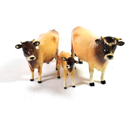
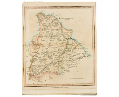
Los 439
A Burmantofts Faience pottery candlestick, lime glaze, impressed factory mark and 1198, 21cm; a Burmantofts Faience pottery twin-handled vase, olive glaze, impressed BF 774, 17cm; and a Burmantofts Faience pottery dimpled vase, pale green glaze, impressed BF 986 WHITE, 10cm (3)Candlestick has been drilled and with subsequent large chip to inside of foot, the centre of body has also been drilled. Crazed throughout. Twin-handled vase with light crazing. remaining vase crazed and with several flea bite chips to the rim.
Los 223
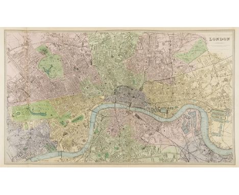
London.- Davies (Benjamin Rees) London, engraving with hand-colouring, platemark 480 x 600 mm. (18 7/8 x 23 5/8 in), sheet 450 x 760 mm. (17 3/4 x 30 in), two vertical folds as issues, some minor nicks and tears to margin edges, light surface dirt, unframed, for the Society for the Diffusion of Useful Knowledge, [1876].
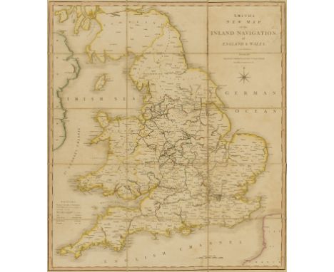
Los 206
England & Wales.- Smith (Charles) Smith's New Map of the Inland Navigation of England & Wales, with details of the inland waterways, or rivers and canals, of England and Wales, engraving with original hand-colouring, 645 x 540 mm. (25 1/2 x 21 1/4 in), dissected and mounted on linen, some folds cracking with minor splits, minor surface dirt and light browning, folding into original slipacse with printer's engraved label to upper cover, worn, 8vo, 1810.⁂ Scarce.
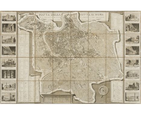
Los 151
Italy.- Rome.- Monaldini (Vincenzo, publisher) Pianta della Citta di Roma con la Indicazione di Tutte le Antichita e Nuovi Abbellimenti, large-scale map covering the city of Rome, decorated along the left and right borders with 16 vignettes illustrating St. Peters Basilica, the Pantheon, Colliseum and Forum amongst others, featuring an index of numerous important buildings with key to the map, engraving, 760 x 1130 mm. (30 x 44 1/2 in), dissected and mounted in linen, with some surface dirt and light rubbing, folding into original marbled slipcase with printer's label to upper cover, and later label affixed partially on top, 8vo, 1832; together with Monaldini's Vestigie di Roma Antica, ancient Rome surrounded by plans of classical buildings on fragments of masonry, engraved plan by Acquaroni, 630 x 840mm., dissected and linen-backed, folding into contemporary marbled slipcase, publisher's printed label pasted on with manuscript title and price in French, 8vo, Rome, 1819 (2).
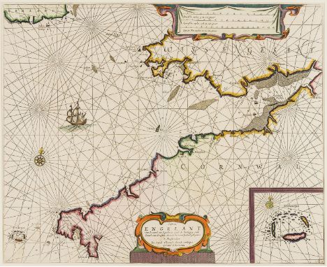
Los 233
Cornwall and Wales.- Jacobsz (Jacob) Cust van Engelant., van Lezard tot Engelands eynd, de Sorlinges..., chart showing the coast of Great Britain from the Helford River to beyond St. David's, with part of the southeast of Ireland and large inset of Scilly, engraving with outline hand-colouring, platemark 430 x 530 mm. (17 x 20 3/4 in)., central vertical fold as issued, some light offsetting and minor browning, unframed, [c. 1676 or slightly later].

Los 137
Swiss Alps.- von Mechel (Christian) Vue perspective de la Partie la plus élevée du Centre de la Suisse où l'on découvre tout le Canton de Lucerne ..., bird's-eye view of the Swiss canton of Lucerne, with text description below, etching and aquatint with hand-colouring on laid paper, 490 x 630 mm. (19 1/4 x 24 3/4 in), under glass, handling creases in upper corners, some surface dirt and light browning, framed, [c. 1790].
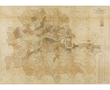
Los 224
London Poverty.- Booth (Charles) Map Shewing Degrees of Poverty in London in areas with about 30,000 Inhabitants in each, Compiled from Information Collected in 1889-1890, detailed map dividing the city into areas with colour-coded key illustrating the extent of poverty in each location, based on Stanford's 'Library map of London', with key and table in the upper and lower right corners, respectively, originally published with the appendix to 'Labour & Life of the People' vol. 2, lithograph printed in colour, sheet 660 x 895 mm. (26 x 25 1/8 in), laid onto linen, some handling creases and light folds, small areas of of loss carefully restored, minor surface dirtr, unframed, [1890-1891].
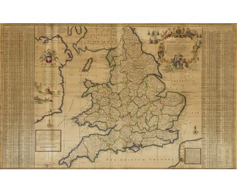
Los 181
Atlases.- British Isles.- Laurie (Richard H., publisher) Laurie's New Traveller's Companion and Guide through the Roads of England and Wales, including Great part of Scotland; with a General Map, and an Index Villaris, &c., title, 8 pp. index, folding map of England, Wales, and part of Scotland, and with 25 double-page linear road maps, engravings with hand-colouring, on wove paper, some sheets watermarked 'J & M Mills 1825', some minor offsetting and light spotting, small area of loss to margin of map of England, Wales and part of Scotland, limp blue calf, worn, 4to, 1828.
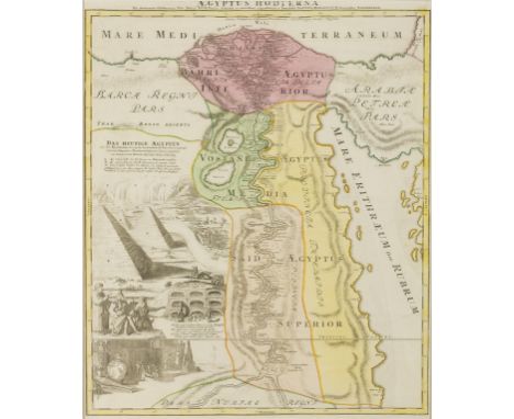
Los 73
Egypt.- Homann (Johann Baptist) Aegyptus Hodierna. Ex itinerario Celeberrimi viri Pauli Lucae, Franci desumta ac novissime repraesentata, map of Egypt focused on the Nile River Valley from the Mediterranean to below the First Cataract at the confluence of the White and Blue Nile, with large scenes of the cataracts, the Sphinx, pyramids, and other various antiquities to the lower left, engraving with hand-colouring, platemark 580 x 475 mm. (22 3/4 x 18 3/4 in), under glass, minor handling creases, some surface dirt and light browning, framed and under glass, [c. 1720].
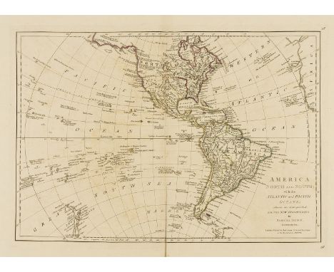
Los 27
Americas.- Dunn (Samuel) America North and South; with the Atlantic and Pacific Oceans; wherein are distinguished all the New Discoveries, map of the Western Hemisphere and most of the Pacific, with much still undiscovered, with description in the Pacific of "Signs of Land," and "Land descry'd by Mendaña in 1568", with New Zealand, "as mapped by Cook", engraving with some outline hand-colouring, platemark 330 x 460 mm. (13 x 18 1/8 in), sheet 470 x 570 mm. (18 1/2 x 22 1/2 in), central vertical fold, with some splitting to lower section, minor surface dirt and light browning and offsetting, unframed, Robert Sayer, 1774.
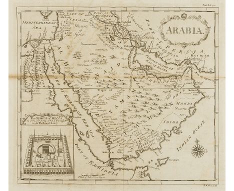
Los 102
Middle East.- Seale (Richard William) Arabia, fine map centered on Arabia, showing Jirja and Alexandria in Egypt, and to the east are Iraq and part of Persia, with Baghdad, Basra and Shiraz, Cabara and Tul, all of the Red Sea, the Persian Gulf and the Bay of Ormuz, with inset "The Temple of Mecca, as it was formerly; from a Draught in the Bodleian Library", engraving on laid paper without watermark, platemark 340 x 390 mm. (13 3/8 x 15 1/4 in), sheet 365 x 470 mm. (14 3/8 x 18 1/2 in), folds as issued, with some splitting to the central horizontal fold at left edge, small tear in the centre right, otherwise some light browning and offsetting, minor surface dirt, unframed, [1764].

Los 141
Switzerland.- von Mechel (Christian) Vue de la Ville et du Pont de Rapperschwyl sur le Lac de Zurich, landscape with Rapperswil and Lake Zurich with the bridge Rapperswil, etching and aquatint with hand-colouring on laid paper, 470 x 630 mm. (18 1/2 x 24 3/4 in), under glass, some light browning and surface dirt, framed, [c. 1791]; together with Vue de la Ville et d'une partie du Lac de Zoug, and Vue du Chateau Baillival ci-devant Episcopal de Lausanne, both etchings and aquatints with hand-colouring, each approx. 470 x 590 mm. (18 1/2 x 23 1/4 in), under glass, some surface dirt and light browning, framed, [c. 1791] (3)

Los 138
Swiss Alps.- von Mechel (Christian) Vue perspective du Mont St. Gothard dessinée d'après un Modéle exécuté enrelief sous la direction de Mr. Exchaquet ..., bird's-eye view of the St Gotthard Pass with surrounding mountains, numbers identify specific locations, including the source of the river Rhine, with text below, etching and aquatint with hand-colouring on laid paper, 500 x 630 mm. (19 3/4 x 24 3/4 in), under glass, some handling creases, minor surface dirt and light browning, framed, Basel, 1792.
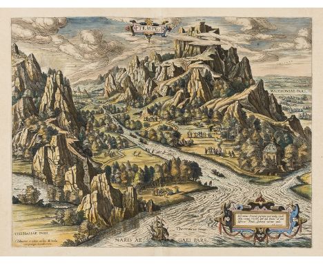
Los 156
NO RESERVE Mount Olympus.- Greek myths.- Ortelius (Abraham) Tempe, bird's-eye view of the mythical paradise of Tempe in Thessaly, located at the foot of Mount Olympus, Greece, engraving with hand-colouring on laid paper without watermark, platemark 360 x 470 mm. (14 1/4 x 18 1/2 in), sheet 425 x 550 mm. (16 3/4 x 21 3/4 in), Latin text verso, central vertical fold as issued, minor handling creases and light cockling, surface dirt, unframed, [circa 1590 or later]; together with a double-page engraved view of the ancient Mesopotamian Kingdom of Babylon, engraving with hand-colouring, sheet 375 x 470 mm. (14 3/4 x 18 1/2 in), unframed, [18th century] (2).
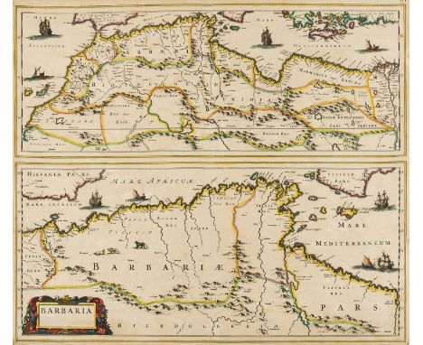
Los 9
Africa.- Barbary pirates.- Blaeu (Johannes) Barbaria, two maps of the Mediterranean coast of Africa, the top map showing the entire coast from C. Bajodor to the Nile delta, including the Strait of Gibraltar, with the bottom map covering present day Algiers, from Mare Ibericum to the island of Malta and a bit of Sicily, both with sailing ships and galleys, engraving with outline hand-colouring on laid paper without watermark, sheet 500 x 590 mm. (19 3/4 x 23 1/4 in), central vertical fold as issued, small hole to centre of fold, marginal nicks, handling creases, surface dirt and light even browning, unframed, [c. 1650].
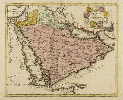
Los 95
Middle East.- Weigel (Christoph) Arabiae Veteris Typus, map showing the Arabian peninsula, decorated with medallions and coins from the region, from Weigel's 'Descriptio Orbis Antiqui in XLIV', engraving with hand-colouring, on laid paper with fleur-de-lis watermark, platemark 320 x 380 mm. (12 1/2 x 15 in), central vertical fold, carefully repaired marginal tears, some surface dirt and light browning, some spotting, unframed, [c. 1720].
Los 205
England & Wales.- Moll (Herman) The Southern Part of Great Britain called England and Wales, with many cities, towns, villages, roads and topographical features, distances given between towns, based on Ogilby surveys, large ornamental title cartouche upper right, Godolphin family coat of arms upper left, side panels with key and information on towns, engraving on two sheets joined, with some outline hand-colouring, sheet 610 x 990 mm. (24 x 39 in), under glass, folds as issued, some light browning and minor defects, 1710.
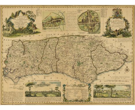
Los 240
Sussex.- Bowen (Emanuel) An Accurate Map of the County of Sussex. Divided into its Rapes, Deaneries, and Hundreds, decorated with vignette views and inset plans of Lewes and Chichester, with two decorative rococo cartouches in the upper corners, engraving with hand-colouring on laid paper without watermark, sheet 525 x 700 mm. (20 3/4 x 27 1/2 in), some minor nicks and tears, light even browning, with minor loss to margin in the lower left corner, unframed, Sold by I. Hinton, 1749 [or slightly later].
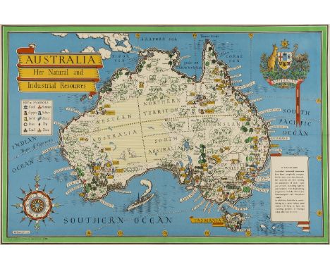
Los 48
Australia.- Gill (Leslie MacDonald) Australia. Her Natural and Industrial Resources, pictorial wartime map of Australia illustrating the Commonwealth country's economic contribution to the war effort, decorative coat of arms in the upper right corner, large compass rose in the lower left, lithograph with hand-colouring, sheet 500 x 740 mm. (19 3/4 x 29 1/8 in), some handling creases and light folds as issued, small repaired tear in the lower margin, printed by Alf Cooke Ltd., 1942.
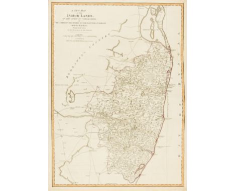
Los 119
India.- Laurie & Whittle (publishers) A New Map of the Jaghir Lands, on the Coast of Coromandel, The Territory Belonging To The East India Company Round Madras From An Actual Survey In The Possession Of The Company, detailed map of the coastal region of India centred on Madras and Fort St. George (Chennai), extending north to Erikans Lake (Pulicat Lake) and south to Cheeyer Tank and Allumparva (Cheyyur) engraving with some outline hand-colouring, on laid paper with large watermark of Strasbourg lily, sheet 730 x 540 mm. (28 3/4 x 21 1/4 in), central horizontal fold as issued, some light offsetting, minor surface dirt, unframed, 1794.
![London Underground and Transport.- Beck (Henry C., "Harry") [Map of London's Underground Railways], Edition No. 2 1937, diagr](https://cdn.globalauctionplatform.com/fd2ab0e9-137d-4d47-b84e-aa9b00b0e600/b7df392f-27f6-4772-b155-aaa300f1c518/468x382.jpg)
Los 229
London Underground and Transport.- Beck (Henry C., "Harry") [Map of London's Underground Railways], Edition No. 2 1937, diagrammatic underground tube map with 'Interchange Stations Central Area' listed verso, colour-printed map, sheet 150 x 230 mm. (5 7/8 x 9 in), two vertical folds as issued, minor rubbing, unframed, London Transport, 1937; together with Geographica Ltd's Underground Railway Map, No. 1, 1937, 440 x 610 mm. (17 1/4 x 24 in), and with Lt-Colonel Mansfield's Bus Map Central Area, No. 2, 1935, 435 x 570 mm., folding, some surface dirt and light signs of use, unframed, 1935 (3)
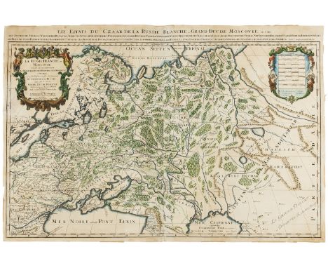
Los 159
Russia.- Jaillot (Alexis-Hubert) La Russie Blanche ou Moscovie Divisee Suivant l'Estendue Des Royaumes Duches, large format map of Russia, extending from the Baltic and Black Seas to Grande Tartarie and the Grande Desert ou Desert De Karkkathay, two large cartouches feature in each corner, engraving on two sheets joined, both with hand-colouring, total sheet 595 x 895 mm. (23 1/2 x 35 1/4 in), repair to splitting just below and to the left of title cartouche, other minor marginal nicks and tears, some surface dirt and light browning, unframed, Covens & Mortier, [1685].
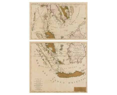
Los 61
Asia.- Southeast Asia.- Mortier (Pierre) Le Royaume de Siam Avec les Royaumes qui luy sont Tributaires et les Isles de Sumatra, Andemaon, etc. et les Isles Voisine, two-sheet map covering part of Thailand, Cambodia, Vietnam, Sumatra, Java and Borneo, engravings with early hand-colouring on laid paper without watermarks, platemarks 480 x 560 mm. (18 7/8 x 22 in), each sheet approx. 530 x 610 mm. (20 7/8 x 24 in), central vertical folds as issued, light even toning, minor spotting and surface dirt, unframed, [circa 1700-1730] (2).
Los 259
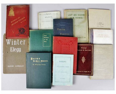
MRS FREDERIC FOWELL: POEMS ON SACRED AND MISCELLANEOUS SUBJECTS, Diss, Edward Abbott, 1866 1st edition, subscribers list, original blind stamped cloth, one copy on COPAC + LUCY BOSWELL OF TOWER HOUSE, THORPE HAMLET: THE ECHOES OF THE HIGHER CHIMES AND OTHER POEMS, Norwich and London, 1884 1st edition, original cloth, not on COPAC + R F BRADDOCK: HARLING, A DESCRIPTIVE POEM, London, no dates, degrees of foxing, original printed wraps, not on COPAC + AUGUSTUS GEORGE LEGGE: POEMS, SACRED AND SECULAR, Norwich, Agas H Goose, 1902 1st edition, original limp leather gilt, one copy on COPAC + FREDERICK STIBBONS KNOWN AS THE NORFOLK BURNS: THRO' WINDOWS OF THE SOUL, Cromer, W & T Cheverton 1911 1st edition, original cloth gilt, not on COPAC + REV H C ASH: AN OLD MAN'S FURTHER MUSINGS, Great Yarmouth, no date, inscribed presentation copy dated 1927, original cloth backed boards soiled, not on COPAC + HILDA L EVERETT: POEMS IN NORFOLK AGAIN, Ely, [1930], original printed boards 3 copies on COPAC+ BEATRICE M HOOK: LIGHT AND SHADOWS FROM NORWICH, London, Arthur H Stockwell, [1926], 1st edition, original printed boards soiled, two copies on COPAC + A H SMITH "A SON OF THE WORKSHOP": HAMMER AND FILE, London 1914 1st edition, original cloth gilt, glassine dust wrapper + J W DE CAUX: POETIC FANCIES: Great Yarmouth 1886 1st edition, inscribed presentation copy, original cloth gilt, one copy on COPAC + FRED HENDERSON: ALICE AND OTHER POEMS, London [1884] 1st edition, original printed wraps, two copies on COPAC + WALTER FITCH: POEMS IN SPARE MOMENTS, Great Yarmouth, W Fitch 1892 1st edition, signed and inscribed, original cloth gilt, one copy on COPAC + OLIVER HAWKSLEY: WINTER ELEGY, Aylsham, F C Barnwell 1935 1st edition, original wraps (13) From the collection of the late Ron Fiske of Morningthorpe Manor.
Los 217
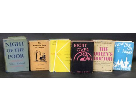
A G MACDONELL: HOW LIGHT AN ANGEL, London, MacMillan, 1934, 1st edition, original cloth, dust wrapper + ROBERT NEWMANN: THE QUEEN'S DOCTOR..., trans Edwin & Willa Muir, London, Victor Gollancz, 1936, 1st edition, original cloth, dust wrapper + E M DELAFIELD: THE PROVINCIAL LADY IN AMERICA, ill Margaret Freeman, London, MacMillan, 1934, 1st edition, original cloth, dust wrapper + FREDERIC PROKOSCH: NIGHT OF THE POOR, London, Chatto & Windus, 1939, 1st edition, original cloth, dust wrapper (tatty) + FRANZ KAFKA: THE PENAL COLONY, trans Willa & Edwin Muir, New York, Schocken Books, 1948, original cloth gilt, dust wrapper + [ERIK FARIA VON KUHNELT-LEDDIHN]: NIGHT OVER THE EAST, trans Edwin & Willa Muir, London, Sheed & Ward, 1936, 1st edition, original cloth, dust wrapper (6)
![IPSWICH GAS LIGHT COMPANY (PUB): A HUNDRED YEARS OF PUBLIC SERVICE [1921], original suede yapp worn](https://cdn.globalauctionplatform.com/47878646-286e-420a-9d10-aa9c00fcb6c8/4c6a79d7-099e-418c-a2e5-aab000d2cfa2/468x382.jpg)
Los 522
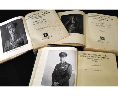
SIR HENRY EVERETT: THE HISTORY OF THE SOMERSET LIGHT INFANTRY (PRINCE ALBERTS) 1685-1914, London, Methuen, 1934, 1st edition, original half calf gilt worn and soiled, + EVERARD WYRALL: THE HISTORY OF THE SOMERSET LIGHT INFANTRY (PRINCE ALBERTS) 1914-1919, London, Methuen, 1927, 1st edition, original half calf gilt, very worn and soiled, lacks backstrip, top board near detached + GEORGE MOLESWORTH: THE HISTORY OF THE SOMERSET LIGHT INFANTRY (PRINCE ALBERTS) 1919-1945), Frome and London, Regimental Committee Somerset Light Infantry, 1951, 1st edition, original cloth gilt soiled (3)

-
534310 Los(e)/Seite