534325 Preisdatenbank Los(e) gefunden, die Ihrer Suche entsprechen
534325 Lose gefunden, die zu Ihrer Suche passen. Abonnieren Sie die Preisdatenbank, um sofortigen Zugriff auf alle Dienstleistungen der Preisdatenbank zu haben.
Preisdatenbank abonnieren- Liste
- Galerie
-
534325 Los(e)/Seite


Los 246
Two (2) Pair English Sterling Silver Table wares. The Lot includes Two (2) Lidded Salts, One With Cobalt Glass Liner, Signed with Hallmarks: Birmingham, 1898, Makers Mark. Light Dings, Measures 2-3/4 Inches Tall; Two (2) Salt Shakers, Signed With Hallmarks: Chester, 1898, Makers Mark, H. Light Dings, Measures 5 Inches Tall. Total Weight for Both Pair, 8.19 Troy Ounces. Shipping $45.00


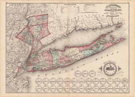
Los 193
Territories of New Mexico and Utah Second state of this very interesting map depicting the region with the largest configurations of the Utah and New Mexico territories. The Utah Territory encompasses all of today`s Nevada and extends west to the Continental Divide into present-day Colorado with Fillmore City as it`s capital. Nebraska and Kanzas Territories bound Utah on the east. New Mexico Territory includes part of southern Colorado and stretches west to include Arizona and the southern tip of present-day Nevada. Locates Fremont`s routes, proposed routes for the Pacific Railroad, the Cimarron Trail, the Oregon Route 1843, the Spanish Trail, and much more. A fine example of a very desirable map that Wheat found important enough to use as the frontis to Volume 4 of his Mapping the Transmississippi West. This is the more desirable edition with decorative borders from the large two volume atlas, dated 1855 and published in 1856-57. A clean, bright example with light toning along edges of sheet. 12.9"" W x 15.8"" H Colton, Joseph Hutchins 1855
![[Lot of 2] Map No. 1 [and] Map No. 2 Reconnaissance and Survey of a Railway Route from Mississippi River near 35th Parallel](http://lot-images.atgmedia.com/SR/36385/2916721/194-2014116143629_468x382.jpg)
Los 194
[Lot of 2] Map No. 1 [and] Map No. 2 Reconnaissance and Survey of a Railway Route from Mississippi River near 35th Parallel to Pacific Ocean These are the larger maps that were included in the rare 8vo Pacific Railway atlas. They should not be confused with the same titled, smaller and much more common maps from the 4vo volume. This pair of matching maps are the result of the explorations and surveys of Lieut. A.W. Whipple and Lieut. J.C. Ives, Topographical Engineers, and A.H. Campbell, Civil Engineer. Wheat says Whipple ""had demonstrated that the route which he had surveyed was practicable for a railroad, and the Santa Fe Railroad now traverses much of it This is an important map, in its two parts, and reflects great credit upon Whipple and his entire party."" The first map extends from the vicinity of Memphis and Vicksburg to the Rio Grande valley at Santa Fe and Albuquerque. Locates forts Arbuckle, Washita, Smith and numerous Indian villages. Drawn by A. Schimmelfinnig. Map No. 2 continues from Albuquerque westward to Los Angeles via Cajon Pass. Also locates forts, Indian lands, pueblos such as Zuni, and the gold and silver mines in New Mexico. Drawn by M. von Hippel. The route of the exploring parties is delineated on both with each camp site indicated. The size given is approximate for each map: together they are over 12 feet in length! These maps are uncommon and are rarely offered together. Issued folding with light offsetting, numerous short splits at fold intersections, and toning along the folds. Map No. 1 has a 3"" binding tear at left. 26.5"" W x 75"" H Whipple, Amiel Weekes 1855
![[Lot of 2] Asher & Adams` Arizona [and] Asher & Adams` New Mexico A. Asher & Adams` Arizona (17.0 x 22.6"&q](http://lot-images.atgmedia.com/SR/36385/2916721/195-2014116143630_468x382.jpg)
Los 195
[Lot of 2] Asher & Adams` Arizona [and] Asher & Adams` New Mexico A. Asher & Adams` Arizona (17.0 x 22.6""). This map shows an early Arizona with five very large counties that composed the territory of the time. The map displays major rivers, numerous mines, military and Indian reservations, and the progress of public surveys. It also depicts a few key roads and two proposed east-west rail lines across the territory. A small Navajo Reservation is noted in the northeast corner and Tucson is shown as the territorial capital. B. Asher & Adams` New Mexico (22.5 x 16.6""). Another double-page map focused on New Mexico with the southern portion of the state shown in an inset at right. 15 counties are noted and Santa Fe is shown as the capital. The map displays major rivers, proposed railroads, Indian and military reservations, the progress of public surveys, and Maxwell Grant along the border with Colorado. Light scattered foxing with some very faint offsetting in the New Mexico map. See description Asher & Adams, 1874

Los 196
Air Navigation Map No. 32 (Experimental) Phoenix, Arizona to San Diego, Calif. In 1921, the United States Army Air Corps initiated a compressive evaluation of aeronautical charts in an effort to develop a standardized map for aerial navigation. Based upon this study, the Air Corps issued 63 air navigation maps covering most of the military routes in the United States. Prior to 1926, these maps were jointly compiled by the Geological Survey and U. S. Army Engineer Reproduction Plant. By 1926, the preparation of air maps shifted to the U.S. Coast and Geodetic Survey (under the Commerce Department) with the passage of the Air Commerce Act. Maps from this point on were intended to merge the growing commercial airways system with the military network. This map covers the area from Phoenix west to San Diego and shows elevation and contours, cities and towns, rivers, roads and railroads. Airfield classifications are shown with different symbols including seaplane landings. True north and magnetic north are depicted. On a scale of 8 miles per inch. Dissected into two panels and backed in linen. A colorful example backed in linen with light toning at bottom and an ex-library stamp on verso. 42.5"" W x 10.3"" H U.S. Corps of Engineers, 1924

Los 199
A Correct Chart of the West Coast of North America from Bhering`s Straits to Nootka Sound Engd. for Malham`s Naval Gazetteer This intriguing chart spans from Queen Charlotte Sound off the coast of British Columbia north to Bering Strait. References are made to the discoveries of Captains Cook, Dixon, and Duncan, but Vancouver`s explorations, contemporaneous with the chart`s publication, do not appear. The name Alaska appears on the Alaska Peninsula. Much of the coastline north of the peninsula is speculative and terminates in Fields, and Mountains of Ice above Bhering`s Straits. The chart was engraved by Neele for Rev. John Malham (1747-1821), a writer and teacher of navigation, for a British edition of The Naval Gazetteer; or, Seaman`s Complete Guide. Issued folding with light offsetting and toning along the sheet`s edges. 7.5"" W x 9.6"" H Malham, John (Rev.) 1795

Los 201
Plan de l`Entree du Port de Bucarelli sur la Cote du Nord-Ouest de l`Amerique... This large-scale chart covers a portion of today`s Prince of Wales, San Fernando, Lulu, Noyes, Baker, and Suemez islands in the Alexander Archipelago in the Alaska Panhandle. There is excellent detail along coastlines plus scores of soundings in bays and harbors. Adorned with a simple compass rose with an arrow indicating north. Engraved by Bouclet. A fine impression on watermarked paper with wide margins, a few small spots, faint offsetting, and a light damp stain along centerfold at top. 19.6"" W x 27.1"" H La Perouse, Comte Jean F. Galoup, de 1797

Los 206
Map of Passes in the Sierra Nevada from Walker`s Pass to the Coast Range: from Explorations and Surveys Made Under the Direction of the Hon. Jefferson Davis Secretary of War... This detailed map of the region centers on Tejon Pass, including the Tulare Valley, and the Kern and Buenavista Lakes. Walker`s Pass, Hum-pah-map Pass, Tah-ee-chay-pay Pass, Tejon Pass, Arroyo de las Uvas, Arroyo de San Arminio, and Fremont`s route through the region are located. A wagon road through Tejon Pass and a new pass leading to Los Angeles are also identified, and topography is denoted through finely engraved hachure. Issued folding, now pressed, with very light toning along a few folds and a couple of small spots. Backed in Japanese tissue to repair several short fold separations. 30.5"" W x 20.1"" H Williamson, R. S. (Lt.) 1853

Los 207
California This is one of the best mid-nineteenth century atlas maps of California. It shows the entire state with Utah and New Mexico territories on the eastern border. Two proposed railroad routes through the Central Valley are labeled ""Explored Route for Atlantic & Pacific R.R."" and a northern route through Fredonyers Pass, north of Pyramid Lake, is marked ""Practicable Route for Atlantic & Pacific R.R."" The only completed railroads service the Gold Regions and Sacramento. A huge inset titled ""City of San Francisco"" shows the planned land expansion into the bay with the streets already drawn in. A clean, bright example with light toning along edges of sheet. 15.9"" W x 12.9"" H Colton, Joseph Hutchins 1855

Los 211
Plan du Port et de la Baie de Monte-Rey Situes sur la Cote Septle. de la Californie This uncommon map is a very early depiction of Monterey and the adjacent coastline. It shows a coastal road from Carmel through the ruins of Presidio de Monte-Rey and north to Santa Cruz. Numerous soundings are noted in Monterey Bay. Eugene Duflot de Mofras was a diplomat stationed in Mexico City. His role was to assess potential French interests (commercial and political) along the western coast of North America and traveled the region extensively. His account appears in Exploration du Territoire de l`Oregon, des Californies et de la Mer Vermeille . A strong impression with wide margins and light scattered foxing. 9.1"" W x 7.1"" H Duflot de Mofras, Eugene 1844
![[Lot of 3 - Dakota Territory] This great set of maps is bound in the original ""Appendix PP. Report of a Reconnai](http://lot-images.atgmedia.com/SR/36385/2916721/219-2014116143710_468x382.jpg)
Los 219
[Lot of 3 - Dakota Territory] This great set of maps is bound in the original ""Appendix PP. Report of a Reconnaissance of the Black Hills of Dakota, Made in the Summer of 1874, by Captain William Ludlow, Corps of Engineers"" dated April 28, 1875 from St. Paul, Minn. The disbound report contains pages 1113 to 1230 plus one plate illustrating fossils. The three maps include: A. Map of a Reconnaissance of the Black Hills, July and August 1874, With troops under command of Lt. Col. G.A. Custer, 7th Calvary, black & white (21 x 25.3"").This is Ludlow`s principle map that shows the entirety of Custer`s reconnaissance of 1874. The map extends from Old Ft. Pierre on the Missouri River to the Little Missouri Buttes and north to the Badlands and the Yellowstone River. In the summer of 1874, Custer took units of his 7th Cavalry and 2nd Infantry Companies on a now famous march from Ft. A. Lincoln into the Black Hills of the Dakotas. On this expedition, gold was discovered, which led to the Black Hills Gold Rush, then to Custer`s massacre and eventually to the tragic end of the Sioux War at Wounded Knee. This map traces Custer`s route through the region of the Black Hills with the date of each encampment. The map contains many interesting notations, such as ""Where they killed the Rees,"" ""Where the sickman was killed"" plus many comments on water, grasslands, springs, etc. The topography is nicely developed and portions of Raynold`s 1859 route is shown. Condition: Light toning on some folds with a few short splits at fold intersections. (B+) B. Map of the Black Hills from a reconnaissance by Capt. William Ludlow Corps of Engineers, black & white (23.3 x 38""). A large map drawn by Sergeant C. Becker and one of three maps resulting from Custer`s Expedition with additional geography from the maps of Warren and Raynolds. It covers the Black Hills between the Belle Fourche or North Fork of the Cheyenne River to the South Fork of the Cheyenne. Drawn on a scale of 3 miles = 1 inch. Topography is nicely developed with portions of Warren`s route of 1857 and that of Raynold`s in 1859 shown. This expedition led to a discovery of gold and the subsequent Gold Rush into the Black Hills. Condition: Light toning along the folds with several clean fold separations. (B) C. A Geological Map of the Black Hills, by Professor N. H. Winchell, To Accompany the Report of Capt. William Ludlow, U.S. Engineers, printed color (17.5 x 25""). In the summer of 1874, Custer was tasked with reconnoitering a route to Bear Butte and exploring the vicinity. Gold was discovered, leading to a major Gold Rush and an intrusion of white prospectors into the Black Hills, which are sacred to the Sioux and Cheyenne. This led to the Battle of Little Bighorn in 1876, and thus to the end for Custer and the 7th Cavalry. A legend in the lower left indicates eleven geological types through coloring and line and was one of three maps included in Ludlow`s report. This map locates numerous creeks and gives detail of timber and topography. Condition: Beautiful bright printed color resulting in a little offsetting with a few short splits at fold intersections. (B+) See description See description U.S. War Department, 1874

Los 221
North America XIV Florida Early and very detailed, steel engraved map of Florida that was published eleven years before statehood. The western panhandle, from Apalachicola to the Perdido River, is shown in an inset on the same scale. South Florida is virtually empty of settlement, but is bisected by a long Indian Path. A large reservation for the Seminole Indians takes in much of the interior of the peninsula and the region around Charlotte Harbor. Lake Okeechobee (here Lake Macaco) is incorrectly located, which is a common error on maps of this period because the region was largely unexplored. The first railroad was chartered three years before this map was issued, but we find no mention of it here. An early map of Florida, published by Baldwin & Cradock. There is a small spot of soiling to the right of the title and light toning along sheet edges. Trimmed close to the neatline at top, apparently as issued. 16"" W x 12"" H SDUK Society for the Diffusion of Useful Knowledge, 1834

Los 223
Florida This map of Florida shows towns, railroads, forts, roads, canals, major rivers, and lakes. There are references to forts, battlefields, and routes used by the Army during the Seminole War. There are also three inset maps detailing Pensacola, Tallahassee, and St. Augustine. The map reflects the configuration of counties in 1838 with the recent organization of Calhoun County. Water routes from St. Augustine and Pensacola to various ports are described above and below the map. Published by Cary & Hart. Original color with a few spots of foxing mostly in the blank margins and light toning along edges of sheet. 13.4"" W x 10.9"" H Tanner, Henry Schenck 1839
![[Lot of 2] Map of the State of Florida Showing the Progress of the Surveys Accompanying Annual Report of the Surveyor Genera](http://lot-images.atgmedia.com/SR/36385/2916721/224-2014116143719_468x382.jpg)
Los 224
[Lot of 2] Map of the State of Florida Showing the Progress of the Surveys Accompanying Annual Report of the Surveyor General for 1859 [and] Florida A. Map of the State of Florida Showing the Progress of the Surveys Accompanying Annual Report of the Surveyor General for 1859, by U.S. State Surveys, from Sen: Ex: Doc. No. 2, 1st Sess., 36th Cong., dated 1859, black & white (24.1 x 23.6""). This state survey map is drawn on a scale of 18 miles to the inch. It shows the topography, vegetation, towns, cities, forts, rivers, lakes, swamps and many early trails and roads. Most of the state is shown as surveyed with a key designating the extent or the work completed. Area extends to show the keys and to Dry Tortugas Island and Ft. Jefferson, and locates Ft. Lauderdale, Boca Rabones, Key Biscayne and scores of smaller keys. It is signed in the plate by Francis L. Darcy, Surveyor General. Condition: Issued folding with several fold separations that have been mostly closed on verso with archival tape and moderate toning along the folds. B. Florida, by Morse & Gaston, circa 1856, hand color (5.0 x 6.7""). This small map of Florida was published in The Diamond Atlas. Despite being issued only a few years before the above map, surveying had only reached as far south as Tampa. Condition: Light toning with faint damp stains. See description See description 1856-59
![Map of Lands Belonging to Florida Farms & Homes, Inc., Located in Clay and Putnam... [on verso] ... Located in Marion Co](http://lot-images.atgmedia.com/SR/36385/2916721/225-2014116143720_468x382.jpg)
Los 225
Map of Lands Belonging to Florida Farms & Homes, Inc., Located in Clay and Putnam... [on verso] ... Located in Marion County... [and] Key Map Showing Central Location of Colony Lands... [with] Florida the Farmer`s Sportsmen`s and Tourist`s Paradise This promotional land map depicts the holdings of Florida Farms & Homes, Inc. in Clay and Putnam counties in central Florida. The transportation network is well depicted with many railroads shown in the area including the Florida East Coast Railway, the Atlantic Coast Railway, and the Georgia Southern and Florida Railway. A table of text at top highlights some information about Putnam County including schools, churches and roads and notes that it is ""one of the most progressive counties in the state."" The verso contains a similar map of the company`s holdings in Marion county as well as an interesting map of the state showing a series of concentric circles with distances from Palatka in Putnam County. Accompanying the map is a very attractive 67-page pamphlet filled with illustrations describing the climate, agriculture and tourism opportunities in the state. Map is near fine with just a few tiny spots and one small edge tear confined to the blank margin and closed on verso with archival tape. Text is very good with some light, pleasant toning. Paper covers are lightly sunned with minor soiling and a few small chips along the edges. 19.8"" W x 26.5"" H 1915

Los 231
The Dole Map of the Hawaiian Islands U.S.A. Being a Descriptive Portrayal of the History, Transportation, Industries and Geography of the Territory of Hawaii, U.S.A. This vivid and graphic map of the Hawaiian islands was published by the Hawaiian Pineapple Co., Ltd. and drawn by Parker Edwards. The eight major islands are shown, with each filled with illustrations highlighting Hawaiian culture, including the ""wettest spot on earth"" on Kauai, a surfer off Waikiki Beach, hula dancing, a native luau, lava flows, a monument to Captain Cook`s 1779 arrival on the island of Hawaii, and plenty of pineapples on the Dole Island of Lanai. Numerous volcanoes appear with their elevations on the island of Hawaii. The ocean is filled with various types of transportation, from a sailing vessel of the first inhabitants (dated 500 A.D.) and a ship of Spanish explorers (dated 1527) to a pineapple barge and an inter-island airplane. A large compass rose with a globe in the middle that centers on the Hawaiian islands and locates them as being 2,089 miles from North America, 5,000 miles from Australia, and 3,445 miles from Japan. Along the top of the sheet is a decorative border featuring a colorful assortment of local plant life, while the lower border includes a sampling of the bright, exotic fish that live around the islands. Minor toning in the blank margins and light soiling at bottom left. 17.4"" W x 35.5"" H 1937
![[Lot of 2] Map of the City of Chicago [and] Atlas of Illinois Counties of Cook, Du Page, Kane Kendall and Will This lot cont](http://lot-images.atgmedia.com/SR/36385/2916721/233-2014116143734_468x382.jpg)
Los 233
[Lot of 2] Map of the City of Chicago [and] Atlas of Illinois Counties of Cook, Du Page, Kane Kendall and Will This lot contains two plans of Chicago and surrounding region by the famous Warner & Beers firm, renowned for their state and county atlases. The first is dated 1875 (13.4 x 16.4"") and is an early and very detailed post-fire map of the downtown region. The map extends to the Union Stock Yards and Brighton Trotting Park at Thirty Ninth Street in the south and up to Wrightwood Avenue and Fullerton Avenues in the north. The map shows and names all streets. Locates Central Park, Douglas Park, Union Park, Humboldt Park and Lincoln Park. The rail lines of several railroads are delineated and named. The large Government Pier and Light House are drawn at the Chicago River as it enters Lake Michigan. Surrounded by a finely engraved border with blank verso.The second map is undated (14 x 16.5"") but is from the same source so circa 1875 seems in order. This map provides a wider view of the area naming Deer Grove, Aurora, Joliet and extending south to include Wilmington with the counties of Reed and Wesley below. Each county is individually colored and all towns of any size are shown in grid block style. Excellent depiction of railroads, all named and most entering Chicago. The map also shows a complex network of Public Roads. A nice pair of maps. Minor soiling in the blank margins along with a few tiny edge tears closed on verso with archival tape. The second map has a chip in the bottom right corner. See description Warner & Beers, 1875
![[Lot of 8] Plat of the Common Field and Town Tract of Kaskaskia [and] Plat of the Claims Within the Tract Called the Grand P](http://lot-images.atgmedia.com/SR/36385/2916721/234-2014116143735_468x382.jpg)
Los 234
[Lot of 8] Plat of the Common Field and Town Tract of Kaskaskia [and] Plat of the Claims Within the Tract Called the Grand Prairie [and] [6 Untitled Maps] This fascinating lot depicts land ownership along the banks of the Mississippi River. The tracts of land in these examples were drawn in the manner of French surveys, with long perpendicular lines to the Mississippi River (presumably allowing river access to the greatest number). Of particular interest is the Plat of the Common Field and Town Tract of Kaskaskia. In the early 18th century, Kaskasia was the French capital of Upper Louisiana due to its proximity to lead mines and its importance as a trading post. It later served as the capital of Illinois Territory and as state capital for one year (1809-1819). A large flood in 1881 caused the Mississippi River to change course, isolating Kaskaskia from the rest of Illinois and situating it as an enclave in Missouri. These maps were originally produced circa 1809 by William and Elias Rector for the General Land Office and later issued for the American State Papers (ca. 1834). The maps include: A. Plat of the Common Field and Town Tract of Kaskaskia (14.0 x 17.8"").B. Plat of the Claims Within the Tract Called the Grand Prairie (7.9 x 13.5"").C. [Untitled - Prairie du Rocher] (14.9 x 9.8"").D. [Untitled - Kaskaskia and Mississippi Rivers] (8.6 x 13.9""). E. [Untitled - Prairie du Pont] (9.5 x 14.7"").F. [Untitled - Cahokia] (17.0 x 14.4"").G. [Untitled - Fort Chartres] (15.4 x 16.5"").H. [Untitled - St. Philips] (14.0 x 9.6""). Issued on sturdy paper with light toning, scattered foxing, and occasional light to moderate offsetting. See description U.S. Government, 1809-34
![[Lot of 4] Plan of the Front Part of the City of New Orleans... [and] Plan of the Front Part of the City of New Orleans, in](http://lot-images.atgmedia.com/SR/36385/2916721/241-2014116143747_468x382.jpg)
Los 241
[Lot of 4] Plan of the Front Part of the City of New Orleans... [and] Plan of the Front Part of the City of New Orleans, in 1818 [and] Plan de la Nouvelle Orleans... [and] Sketch of Part of the State of Louisiana... The first three maps are based upon the original plans by Joseph Pilie, surveyor for New Orleans, which were included in Memorial of the Mayor, Aldermen, and inhabitants of New Orleans (HR Doc. 26, 20th Congress, 1st Session). The first plan shows the entire city laid out in a grid pattern with 18 important buildings identified by a key. The second and third show the first few streets that border the Mississippi River including the custom house, water works and Market Hall. The third map also shows the improvements made to the quays and levees. The last map, which is not listed in Claussen & Friis, depicts the course of the Mississippi River from north of Nachez, Mississippi to the Gulf of Mexico. It shows the drainage network of trenches and embankments along Lake Chetimaches (Grand Lake) and Lake Ponchartraine. A. Plan de la Nouvelle Orleans, sur les Manuscrits du Depot des Cartes de la Marine, by Joseph Pilie, black & white (10.8 x 7.6"").B. Plan of the Front Part of the City of New Orleans, in 1818, by Joseph Pilie, black & white (21.9 x 7.3"").C. Plan of the Front Part of the City of New Orleans. Shewing the Additions, Alterations and Improvements Made on the Old Quays and Levees of the Said City..., by Joseph Pilie, black & white (21.9 x 7.1"").D. Sketch of Part of the State of Louisiana Accompanying a Report of the Commissioner of the Genl. Land Office of the 12th of January 1829, hand color (18.6 x 22.5""). The first three maps are in very good condition with some minor scattered foxing. The fourth map is in good condition with light to moderate toning, very faint offsetting, and a few damp stains. See description U.S. Government, 1860
![[Lot of 2] The District of Main from the Latest Surveys [and] The Province of Maine from the Best Authorities A. The Distric](http://lot-images.atgmedia.com/SR/36385/2916721/243-2014116143750_468x382.jpg)
Los 243
[Lot of 2] The District of Main from the Latest Surveys [and] The Province of Maine from the Best Authorities A. The District of Main from the Latest Surveys, by Jedidiah Morse, from Morse`s American Universal Geography, published 1793 (8.0 x 10.6""). This scarce and finely engraved map from the American Universal Geography is considered the first obtainable map that focuses on Maine. The northwest boundary with Canada has the notation ""High Lands Being the Boundaries between the United States and Canada."" This gives a northern border further north than that which was eventually decided. Only four counties are noted and Moosehead Lake is misspelled Mousehead Lake. Longitude is measured east from Washington and Philadelphia. This early edition varies from later Morse issues with finer engraving, a notation to the left of the compass rose, the title contained in an oval cartouche, and no outer neatline. Condition: Issued folding with light soiling and a printer`s crease near the top neatline. B. The Province of Maine from the Best Authorities, by E. Low, for Low`s New Encyclopaedia, dated 1811 (7.3 x 10.6""). This is a reduced version of Samuel Lewis` map of 1794. It contains early information on the coastline, watershed and topography. Settlement is limited to the extreme southwest with a wagon road connecting York, Falmouth, Portland, Casco, Yarmouth, and extending perhaps as far as Fort Western. The frontier forts of Pownal and Halifax are noted. The northern boundary is per the Treaty of 1783. Condition: Issued folding with just a few faint spots and a tiny hole near the St. Croix River. See description See description 1793-1811

Los 245
Plan de la Ville de Boston et Ses Environs... Attractive early plan of Boston and the harbor including Charles Town and Isle Ronde. It shows the street plan of the town and wharves, and locates gun batteries, powder magazines, Presbyterian churches, prison, town hall, windmill, and beacon. It indicates an offshore anchorage and the entrance channel and also depicts shoreline topography with the roads running down to the harbor. Large key at left lists sixteen important sites. Engraved at bottom neatline is Tome XIV, No 10. This is very similar to the 1764 Bellin issue from the Petit Atlas Maritime, Tome I, No. 31, but is slightly larger and the title and index are placed on the left. Issued folding on watermarked paper with light toning, minor offsetting, and a binding trim at top left replaced with old paper. 6.5"" W x 10.8"" H Bellin, Jacques Nicolas 1757
![[Lot of 2] Plan of the Redoubt and Intrenchment on the Heights of Charles-Town (Commonly Called Bunker`s Hill
) [and] A Plan](http://lot-images.atgmedia.com/SR/36385/2916721/246-2014116143755_468x382.jpg)
Los 246
[Lot of 2] Plan of the Redoubt and Intrenchment on the Heights of Charles-Town (Commonly Called Bunker`s Hill ) [and] A Plan of the Action at Bunker`s Hill, on the 17th of June 1775. Betwen His Majesty`s Troops The first Bunker Hill item is the complete 48 page issue of the September 1775 Gentleman`s Magazine containing much early Revolutionary War news. Included is a half page plan of the defenses of Bunker Hill with related text, copies of letters to and from George Washington, and a copy of a letter from John Hancock to King George. The second is a very detailed mid 19th century reproduction of Bunker Hill showing the positions of the American and British troops. Also shown are British ships (named) with direction of fire during the battle. Includes a profile view of Charlestown and an inset ""Plan of Redoubt on Bunkers Hill."" A. Plan of the Redoubt and Intrenchment on the Heights of Charles-Town (Commonly Called Bunker`s Hill ), from The Gentleman`s Magazine ... September, 1775, published 1775 (3.9 x 3.9""). Condition: Mild toning. The text has an occasional spot of foxing. B. A Plan of the Action at Bunker`s Hill, on the 17th of June 1775. Betwen His Majesty`s Troops..., by Page/G.P. Putnam, circa 1856 (8.7 x 7.4""). Condition: Light toning with a few small spots. See description See description 1775-1856

Los 248
Boston Harbour from the Survey of A. S. Wadsworth Esq. U.S.N. and the Chart of Des Barres This chart gives excellent navigational detail of Boston Harbor, with soundings, rocks, shoals, anchorages, and lighthouses noted. The chart was based on earlier surveys, including a US Navy survey from 1817 and British surveys from the Revolutionary War period. Drawn by Edmund Blunt and engraved by Hooker.This map was published in the American Coast Pilot, a detailed guide to harbors, capes and headlands on the east coasts of North and South America including information on winds, currents, tides as well as latitudes and longitudes. The American Coast Pilot was published in 21 editions between 1796 and 1861, until it was replaced by federally-funded charts produced by the US Coast Survey Issued folding with light scattered foxing and minor creasing. 8.2"" W x 10.3"" H Blunt, Edmund 1855
![The Geology of Nantucket [with] Map of the Island of Nantucket Showing the Distribution of Glacial and Post-Glacial Deposits](http://lot-images.atgmedia.com/SR/36385/2916721/251-201411614384_468x382.jpg)
Los 251
The Geology of Nantucket [with] Map of the Island of Nantucket Showing the Distribution of Glacial and Post-Glacial Deposits This is one of the earliest comprehensive geologic reports of Nantucket, with detail on geologic history, surficial deposits, coastline and beaches. Included in the report are nine plates and a colored folding map entitled Map of the Island of Nantucket Showing the Distribution of Glacial and Post-Glacial Deposits (10 x 5.5""). The attractive map shows four different geologic units depicting kame and maraine, frontal terrace, post-glacial deposits and swamps. The map was completed by N.S. Shaler. 54 pp. of text enclosed in blue paper wrappers. Map is very good with some light color offsetting. Text and plates are very good to near fine with a few occasional spots. The covers are lightly stained with an old library stamp on front cover and a small portion of the back cover replaced with matched paper. 9.2"" W x 6"" H U.S. Geological Survey (USGS), 1889

Los 254
Map of the Siege of Vicksburg, Miss. by the U.S. Forces under the Command of Maj. Genl. U.S. Grant This large battle map identifies Union and Confederate entrenchments with blue and red hand color, respectively. It details the roads, streets, houses, railroads, vegetation and more. Topographical information shown by hachure. At right are elevations of several batteries, both Confederate and Union, also four profiles of different entrenchments are illustrated. This map is regarded as the best contemporary depiction of this important, pivotal Civil War battle. Drawn by Charles Spangenbery. Engraved on stone by J. Schedler. Illustrated on page 137 in the later edition of Stephenson. Light toning along the centerfold. 29.5"" W x 27.5"" H U.S. War Department, 1863

Los 255
Air Navigation Map No. 23 (Experimental) Saint Louis to Kansas City, MO. In 1921, the United States Army Air Corps initiated a compressive evaluation of aeronautical charts in an effort to develop a standardized map for aerial navigation. Based upon this study, the Air Corps issued 63 air navigation maps covering most of the military routes in the United States. Prior to 1926, these maps were jointly compiled by the Geological Survey and U. S. Army Engineer Reproduction Plant. By 1926, the preparation of air maps shifted to the U.S. Coast and Geodetic Survey (under the Commerce Department) with the passage of the Air Commerce Act. Maps from this point on were intended to merge the growing commercial airways system with the military network. This map covers the area from St. Louis west to Kansas City and shows elevation and contours, cities and towns, rivers, roads and railroads. Airfield classifications are shown with different symbols. True north and magnetic north are depicted. On a scale of 8 miles per inch. A colorful example with light toning mostly in the blank margins. Backed in linen. Ex-library stamp on verso. 38.4"" W x 10.3"" H U.S. Corps of Engineers, 1923

Los 256
Montana Territory This is the uncommon large edition map that shows in great detail the extent of public surveys in Montana just two years before attaining statehood in 1889. Hydrology and topography are well developed on this colorful map. The map shows Indian reservations (Blackfeet, Flathead etc.), military posts (Forts - Assiniboine, Keogh, Maginnis, Custer, Camp Baker, etc.) and the completed and proposed railroads. Also locates Custer Hill, Custer`s Monument, and the Reno battlefield; and Yellowstone National Park in its entirety with major features identified. Remarkable detail throughout on a scale of 1 inch to 15 miles. Extensive legend identifies land offices, Surveyor Generals Office, county seats, towns, villages and railroad stations, railroads (completed and proposed), military reservations, Indian reservations, railroad land grant limits, etc. A colorful example issued folding with light color offsetting and several splits along the folds at bottom mostly closed on verso with archival tape. 26"" W x 39"" H General Land Office, 1887
![Map of the Territory of New Mexico, made by order of Brig. Gen. S. W. Kearney
[with] Report of Lieut. J. W. Abert, of his E](http://lot-images.atgmedia.com/SR/36385/2916721/261-2014116143820_468x382.jpg)
Los 261
Map of the Territory of New Mexico, made by order of Brig. Gen. S. W. Kearney [with] Report of Lieut. J. W. Abert, of his Examination of New Mexico, in the Years 1846-47 During the War with Mexico, Lieutenants Abert and Peck were enroute to the Pacific with Lieut. Emory as part of General Kearny`s Army of the West, but the two were left behind due to illness. They took the opportunity to continue their survey efforts earlier started on Fremont`s third expedition. The resulting map is a very detailed look at the Rio Grande Valley and some adjacent areas including the pueblos of Laguna and Acoma. This important map, illustrated in Wheat, is roughly centered on Santa Fe. It details the territory along the Rio Grande from above Taos south to well below Socorro and San Antonio to the ruins at Valverde. Excellent detail of the topography and watershed to either side of the river with the mountains shown via hachure. Filled with place names including numerous villages and small towns, and the Comanche Route from Arkansas. Blank areas to the west and north are labeled Navajo Indians and Utah Indians. This map was issued with Emory`s Notes of a Military Reconnaissance in 1848. 10,000 copies were produced for this House of Representatives edition. This lot includes the unbound Abert`s report. Unbound, title page, pages 417 - 614, 24 plates, 7.3 X 4.3"" The plates include: Santa Fe; O-CUM-WHO-WUST; Old Bark`s Son AH-MAH-NAH-CO and Squaw; Las Cumbres Espanolas; San Miguel; Ruins of Pecos; The Gold Mountains near Tuerto; Fort Marcy and the Parraquia - Santa Fe; San Felippe; Pueblo de Santo Domingo; Pueblo de Santa Ana; Moquino; Acoma, No. 1; Acoma, No. 2; Acoma, No. 3; View near Rito; El Canon Inferno; Ruins of Abo; Bosque de Apache; Valverde, and four more. Historical and important map complete with its report. The map is very good with light toning along a few folds, one tiny split at a fold intersection, and an archivally repaired tear that enters 3"" into map at top left. Disbound text and plates have occasional light scattered foxing, otherwise clean and bright. 25"" W x 19.5"" H Abert & Peck, 1846-47

Los 265
Map of the State of New-York with Part of the States of Pennsylvania, New-Jersey &c. This is Lay`s rare, separately published wall map of the great Empire State. Lay first published this map of the entire state of New York in 1817, based on previous editions in 1801 and 1812 that only depicted the northern portion of the state. According to Ristow, the 1819 edition was the first revision of the map, with further editions in 1822, 1823, 1824, and 1826. The map shows the majority of Pennsylvania, extending south to Philadelphia, and includes parts of New Jersey, Connecticut, Massachusetts, and Vermont. The map also provides a detailed view of the Canadian border just a few years after the United States declared war on Great Britain in the War of 1812. The map shows most of Lake Erie and all of Lake Ontario with the counties of Upper Canada well shown. It delineates the St. Laurence River to St. Regis at the US/Canada boundary. There is excellent detail of county development, roads, turnpikes, courthouses, forts, mills, Indian villages, battlefields, and iron works, identified by a key at top left. The ""proposed"" routes of the Erie Canal are shown extending to the Hudson River, with construction already having begun in 1817. The eastern end of Long Island is inset in the Atlantic. County development is up-to-date for 1818, with the newly organized Tompkins county, but prior to Seneca extending south into Tompkins in 1819.Printed on 8 sheets, joined. A nice impression with original outline color that has been partially refreshed and a few printer`s creases at top left. There is light soiling and scattered foxing in the bottom half of the map, becoming more moderate in the top half. There are professional repairs to a few small holes, primarily in northeast Pennsylvania. There are some tears and cracks (mostly 1"" to 4"" in length, with one 6"" crack at top right) that have also been professionally repaired. Margins have been extended a bit to accommodate framing. 50"" W x 50.1"" H Lay, Amos 1819
![[Lot of 2] City of New-York [and] A New Map of New York with Its Canals, Roads & Distances from Place to Place Along the](http://lot-images.atgmedia.com/SR/36385/2916721/266-2014116143828_468x382.jpg)
Los 266
[Lot of 2] City of New-York [and] A New Map of New York with Its Canals, Roads & Distances from Place to Place Along the Stage & Steam-Boat Routes A. City of New-York, dated 1835 (12.2 x 15.3""). This detailed map of Lower Manhattan extends to 37th street. The city is divided into wards with an index at left and right to public buildings, hotels and churches. B. A New Map of New York with Its Canals, Roads & Distances from Place to Place Along the Stage & Steam-Boat Routes, dated 1840 (13.6 x 11.3""). Handsome map of the state showing counties, roads, railroads, canals and towns. A profile of the Erie Canal appears below the title. At right are 3 tables detailing the steamboat routes from New York to Albany, New York to Niagara Falls and New York to Philadelphia. Original color with minor soiling and light toning along edges of sheet. See description Tanner, Henry Schenck 1835-40
Los 269
Asher & Adams New Topographical Atlas and Gazetteer of New York. Putnam, Rockland, Westchester, New York, Richmond, Kings, Queens, and Suffolk Counties This striking map covers the region of Downstate New York, which includes Manhattan, Long Island, and nearby counties Putnam, Rockland, and Westchester. Neighborhoods are delineated, and towns, railroads, canals, post offices, wagon roads, harbors, and more are located. Bordering parts of New Jersey, Pennsylvania, and Connecticut are visible as well. At the bottom of the map is a ""time indicator"" comparing the time in Albany with the times in 29 nearby towns. Original color with light toning along the centerfold and the sheet`s edges. 16.3"" W x 22.4"" H Asher & Adams, 1870

Los 273
City of New-York This plan covers Manhattan as well as parts of Williamsburg and Brooklyn. Manhattan is shown in great detail as far north as 37th Street. Locates ferry routes, docks, and names all streets. Tables at sides index more than 200 important public buildings, hotels, and churches. Original color with a few minor spots of foxing and light toning along edges of sheet. 15.5"" W x 12.4"" H Thomas, Cowperthwait & Co., 1850

Los 277
North Carolina from the Latest Surveys Early nineteenth century map of the state with great detail and good representation of the Outer Banks. At bottom left is an inset entitled ""Western Part of North Carolina on the same scale"" containing Buncombe and Haywood counties. Haywood and Columbus counties, which were established in 1808, were the newest counties at the time the map was published. Interestingly, Anson County is delineated, but not named, despite the fact that it was established in 1750. Towns, roads, rivers, mountains and swamps are well depicted throughout, with the exception of Haywood County, which is noted as ""not surveyed."" Original color with light offsetting, moderate toning along centerfold, and light soiling. 11"" W x 18.6"" H Lewis/Carey, 1814

Los 279
Asher & Adams` Indian Territory and Texas North West Portion This map shows lands ceded to numerous Indian Tribes and was intended as a railroad map of Indian Territory. The Missouri-Kansas-Texas Railroad runs north-south along the eastern border of Indian Territory, and was the first railroad to enter Texas from the north, reaching Dallas by 1886. The proposed route for the Texas Pacific Railroad is also shown, which was intended to extend between Marshall, TX and San Diego, CA, but instead was connected with the Southern Pacific Railroad at Sierra Blanca, Texas in 1881. Light offsetting with a few spots of foxing in the image. 16.4"" W x 23.1"" H Asher & Adams, 1874

Los 280
Annual Report of the Board of Regents of the Smithsonian Institution, Showing the Operations, Expenditures, and Condition of the Institution to July, 1885. Part II This Smithsonian report, written by Thomas Donaldson, contains the significant ""George Catlin Indian Gallery"", which consists of numerous plates and two large folding maps: Indian Territory (32 x 24"") and Map Showing Indian Reservations within the Limits of the United States... (33 x 21""). The map of Indian Territory shows the allocation of land among 50 different Indian tribes and depicts 25 different regions, naming 7 more. A small portion of the panhandle is shown and labeled Public Lands. The map of the United States shows the network of Indian reservations primarily confined to west of the Mississippi. Includes inset maps of Indian Territory, southern California and Alaska. 939 pp., octavo, hardbound in brown cloth. Maps and text are clean, bright, and near fine. The United States has a very small, 0.5"" binding tear. Covers and spine have light shelf wear. 9.3"" W x 6.2"" H Smithsonian Institute, 1886

Los 282
Clason`s Guide Map of Oklahoma Detailed map of the new state of Oklahoma shows counties, county seats, roads, railroads and national forests. Numerous oil fields are prominently depicted in red shading. The panhandle is shown in an inset at bottom left with a county index along the right border. A note in the lower blank margin states ""The Road Information Department of the Clason Map Company, Denver, Colo., will be glad to hear of new or improved roads that should be shown on this map."" Issued folding with light toning and offsetting, some soiling, and a few small splits at fold intersections and along the folds in the bottom blank margin. A tear that extends 4"" into map at top has been closed on verso with archival tape. Front paper wrapper is missing. 16.5"" W x 20.3"" H Clason Map Company, 1910

Los 288
South Carolina This is the second state of this delicately engraved map of the Palmetto State with the addition of roads and new place names. It details topographical features, watershed, towns, and villages. As is typical of maps of South Carolina from this era, the state appears in a strange, elongated shape due to the use of an exaggerated north and south scale. Four Holes Swamp is identified north of Charleston, and there are two Greenvilles, one above black Creek, the other below Reedy River. Engraved by Doolittle. There is one tiny hole and a couple of short separations along the centerfold that have been closed on verso with archival tape. An edge tear at bottom that just enters the neatline has also been closed with archival tape, and there is light toning, mostly concentrated along the centerfold. There are two chips in the right blank margin, away from image. 5.9"" W x 7.8"" H Carey, Mathew 1801
![[Lot of 2] A New Map of South Carolina with Its Canals, Roads, & Distances from Place to Place Along the Stage & Ste](http://lot-images.atgmedia.com/SR/36385/2916721/290-201411614399_468x382.jpg)
Los 290
[Lot of 2] A New Map of South Carolina with Its Canals, Roads, & Distances from Place to Place Along the Stage & Steam Boat Routes [and] Colton`s South Carolina A. A New Map of South Carolina with Its Canals, Roads, & Distances from Place to Place Along the Stage & Steam Boat Routes, by Thomas, Cowperthwait & Co., dated 1850 (14.2 x 11.4""). A handsome map with a large inset of Charleston showing numerous buildings, streets and places of interest identified. Good detail throughout, locating numerous towns and villages, rivers and several railroads. Table gives the steamboat routes between Charleston and Savannah, and Savannah to Augusta. Decorative borders. Condition: Light toning confined to sheet edges. B. Colton`s South Carolina, by G.W. & C.B. Colton & Co., dated 1855 (15.9 x 13.0""). Fine state and county map with terrific detail throughout showing railroads, common roads and canals. A large inset: ""Plan of Charleston, Vicinity and Harbor"" shows the harbor, Cooper and Wando rivers, and the city in good detail. Surrounded by Colton`s decorative border. Condition: There are a few edge tears at top away from the map image (one passes the decorative border) closed on verso with archival tape. See description See description 1850-55

Los 291
A Plan of the Attack of Fort Sulivan, near Charles Town in South Carolina This rare Revolutionary War battle plan depicts a pivotal British naval assault on Fort Sullivan, near Charleston, South Carolina. Charleston was a critical location as it was the largest city and only port in the South. In the summer of 1776, the British dispatched a fleet of ships to regain the possession of Fort Sullivan from the Americans. The map shows the original positions of the British ships, along with their regiment numbers, in the upper-right corner. An inset map depicts the plan of Fort Sullivan. Behind the fort, a makeshift ""bridge of boats"" connects Sullivan`s Island with the mainland and the site of the Rebel`s camp. The British ships are illustrated near the fort along with their names and the number of guns on each. Due to tactical errors and misinformation, the British lost the battle despite the fact that they had more than double the manpower and firepower than the Americans. This is the first state of the map, and includes a dedication to Commodore Sir Peter Parker by Lt. Colonel Thos. James. Original color and wide margins, with light toning confined to the blank margins. 11"" W x 14.6"" H Faden, William 1776

Los 292
Map of Charleston Harbor S.C. This uncommon chart shows the approaches to Charleston. It was first published in 1835 and republished in the American State Papers. Using a scale of 4 inches to the mile, it served as the basis for subsequent maps of the Coast Survey. A key at lower left states ""The curves drawn in red represent lines on the bottom of the harbor at the depths of 6, 12, 18, and 24 feet below mean low water. The part of the Harbor where the water is 18 feet deep is colored with India ink. The surface always covered with water is colored blue. The surface between high and low water marks is colored with bistre."" Shows drainage, vegetation, cultivated areas, swampland and roads. The forts are prominently featured, and nine inch circles delineate the range of their guns. Fort Sumter, with smaller guns, uses six inch lines to show their range. Issued folding with light offsetting, a tiny 0.25"" binding tear at left closed on verso with archival tape, and a few small damp stains mostly in the top blank margin. 17.5"" W x 22.5"" H Bowen & Co., John T. 1860
![[Untitled - Port Royal, South Carolina] This fascinating engraving depicts Port Royal Sound and the surrounding area, and is](http://lot-images.atgmedia.com/SR/36385/2916721/293-2014116143913_468x382.jpg)
Los 293
[Untitled - Port Royal, South Carolina] This fascinating engraving depicts Port Royal Sound and the surrounding area, and is based on the discoveries of Jean Ribault, a French naval officer. In 1562, Ribault was sent to the New World to colonize portions of southeastern US. After exploring the mouth of the St. John`s River in present-day Jacksonville, Florida, Ribault and his fleet of 150 colonists headed north, finding their way to Port Royal Sound. They established a settlement on Parris Island and erected a small fort, naming it Charlesfort after the French king Charles IX. The French noted the area as being ""well wooded with oak, cedar and other types of trees"" and spotted wild turkeys and stags, which are depicted in the engraving. The explorers continued further up-river and came upon Native Indians who fled at the sight of the ship. The Indians left behind a wolf roasting on a spit, leading the French to name the point Prom. Lupi, which is marked on the engraving.This engraving first appeared in de Bry`s Grands Voyages in 1591, and was republished in Johann Ludwig Gottfried`s Historia Antipodum, a collection of voyages. Matthaus Merian, de Bry`s son-in-law and publisher for Historia Antipodum, was granted access to de Bry`s copper-engraved plates. On a full sheet of German text measuring 9.2 x 14.7"". Nice impression and color with light toning along edge of sheet at right, and a few tiny tears at right that have been archivally repaired. Narrow right margin, as issued. 6.1"" W x 8.6"" H Bry, Theodore de 1631

Los 297
Texas This rare map of Texas was issued in Edward Stiff`s The Texan Emigrant: Being a Narration of the Adventures of the Author in Texas and was intended as a guide for people who planned to settle in Texas. Howes calls it ""one of the most objective accounts of Texas affairs issued in the days of the Republic."" The map itself is similar to those issued by William Hooker several years earlier but with fewer details. Texas is shown in its smaller Republic configuration with the Nueces River designated as the southwestern boundary of Texas. Fourteen land grants are named including Beales Grant, Austin & Williams Grant, and DeWitts Grant to name just a few. Austins Colony locates many settlements including San Felipe de Austin, Houston, Columbus and Montgomery. Engraved by Doolittle & Munson and published by George Conclin in Cincinnati. An important map rarely seen on the market. Issued folding and now flattened and backed with linen to reinforce and repair several short fold separations and a 1.5"" binding tear at lower right. Light soiling and moderate toning. 9.4"" W x 11.4"" H 1840

Los 298
Map of Texas from the Most Recent Authorities This is a very early map of the new state of Texas drawn by J.H. Young. It portrays early counties, towns, and villages and shows ""Texas North of the Red River"" in an inset at lower left. This panhandle extends north to the Green Mts., just west of Pikes or James Peak in present-day Colorado, and west to the Rio Grande River, thus incorporating Santa Fe and Taos. There is a comment taken from Arrowsmith`s 1841 map in West Texas that the area ""as far as North Canadian Fork was explored by Le Grand in 1833, [and] it is naturally fertile, well wooded, and with a fair proportion of water."" San Patricio County occupies the south tip, while Bexar, Milam and Robertson counties take up the majority of the western region. Several early roads are depicted including the Presido Road, and Fort Alamo, mines, and the Presidios of Rio Grande, del Norte el de las Yuntas, del Paso del Norte are identified. This map was included in H.S. Tanner`s New Universal Atlas published in 1845. Original color with a small amount of color offsetting to the left of the title cartouche and light toning primarily along sheet edges. There are several knife cuts along the platemark at top (far from the image) that have been archivally repaired. 12"" W x 14.5"" H Williams, C. S. 1845
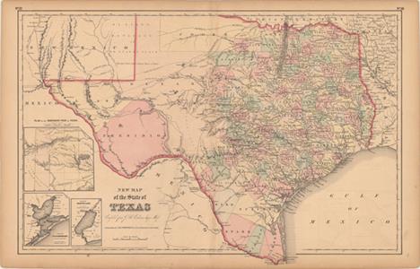
Los 300
New Map of the State of Texas Compiled from J. De Cordova`s Large Map This handsome Texas map is based on an important 1849 map by Jacob de Cordova, which was the first to be drawn from General Land Office records. It shows extensive detail throughout the settled part of the state. The western third is comprised of the large unsettled areas of Presidio, El Paso, Bexar and El Llano Estacado or the Staked Plain. Cooke County in the northern part of the state is oversized and extends well into the Staked Plain. The other county development is consistent with 1855-56, indicating that this was likely published circa 1857. Railroads, forts, post offices, roads, springs, and topographical detail are all clearly indicated. Three insets show the panhandle, Galveston Bay, and Sabine Lake. Original color with light offsetting, faint scattered foxing, and toning around the sheet`s edges. There is a tiny centerfold separation in the bottom blank margin. 16.5"" W x 24.9"" H Colton, Joseph Hutchins 1855
![[Lot of 2] County Map of Texas [and] Texas [on sheet with] California A. County Map of Texas, by Samuel Augustus Mitchell Jr](http://lot-images.atgmedia.com/SR/36385/2916721/301-2014116143928_468x382.jpg)
Los 301
[Lot of 2] County Map of Texas [and] Texas [on sheet with] California A. County Map of Texas, by Samuel Augustus Mitchell Jr., dated 1860 (13.5 x 10.8""). One of the most attractive maps of the state of Texas, inset with a map of Galveston Bay, and Vicinity. West Texas is made up of Young Territory, Bexar Territory, El Paso and Presidio counties, and clearly shows the Llano Estacado or Staked Plain with a notation about the region being ""destitu[t]e of both wood and water."" Erath County is mistakenly identified as ""Earth"" County. The map shows trails, roads, a limited railroad system that extends only into Austin, and proposed railroads indicated by dashed lines. The map is surrounded by a fine floral border. Copyright date 1860, published circa 1864. The county development is up-to-date for 1864 as Dawson County, abolished in 1866, is included. Condition: Light toning with a narrow top margin, a faint damp stain at bottom right, and a crease at top right. B. Texas [on sheet with] California, by S.S. Cornell, dated 1856 (12.8 x 10.1""). This map was published in Cornell`s High School Geography... and shows both Texas and California on one sheet. West Texas is composed of El Paso and Presidio counties and Bexar Territory. Development is confined to the eastern portion of the state. Shows ""Laredo Road"" and ""Route to Ft. Smith."" Published by D. Appleton & Company. Condition: There are a few edge tears including one that extends 1"" into the image at left, which have been closed on verso with archival tape. See description See description 1856-60

Los 302
Galveston Entrance Texas From a Trigonometrical Survey This coastal survey chart details the entrance to Galveston Bay. It includes a town plan of Galveston without streets named. The chart extends to Pelican Island, Bird Key, and Bolivar Point. It locates buoys, a beacon, a light boat, and is filled with soundings, bottom types and extensive notations on sailing directions. Triangulations were completed by R.H. Fauntleroy and J.S. Williams. Issued folding with light toning along the folds and one tiny hole at a fold intersection. 13.5"" W x 17"" H U.S. Coast Survey, 1853
![Map of the Great Salt Lake and Adjacent Country in the Territory of Utah [on sheet with] The Great Salt Lake (Mormon) City a](http://lot-images.atgmedia.com/SR/36385/2916721/303-2014116143932_468x382.jpg)
Los 303
Map of the Great Salt Lake and Adjacent Country in the Territory of Utah [on sheet with] The Great Salt Lake (Mormon) City and Surrounding Country (on an Enlarged Scale) This sheet contains two maps. The upper map covers the region from the Great Salt Lake and Lake Utah east to Vernal and the Ashley Creek area (unnamed) and Fort Bridger in the north. It shows Salt Lake City in a block plan. Also locates Ogden, but no sign of Logan. Fort Utah is on the eastern shore of Lake Utah. The lower map is centered on Salt Lake City and features much more detail. The city plan clearly shows its rectangular grid layout and wide streets. The Welsh Settlement is shown to the southwest on the other side of the Jordan River. Both maps delineate the mountains in hachure and good detail of watershed. Lithographed by Day & Son. Drawn and engraved by Edward Weller of Bloomsbury. A scarce issue, more so due to the yellow, embossed stamp on the upper left noting this map was published as a supplement to the Sunday Weekly Dispatch of July 11th, 1858. Light toning and soiling. 12.3"" W x 12"" H Weller, Edward 1858

Los 304
Vermont from Actual Survey This early map of Vermont is the second edition as evidenced by ""Engraved for Carey`s American Edition of Guthrie`s Geography Improved"" above the neatline and the number 25 at upper right. It is divided into seven counties with townships shown and named. The major towns, Dartmouth College, and a fairly extensive road network is delineated. Engraved by Amos Doolittle, a New Hampshire cartographer and engraver who produced many of the best early maps of New England. This map of Vermont is a fine example of his work. A nice impression on watermarked paper with wide margins, a couple of light creases, and faint offsetting. 14.7"" W x 11.9"" H Carey, Mathew 1795

Los 305
Washington Sound and Approaches Washington Territory This chart details the area centered on the San Juan Islands and is filled with soundings, two magnetic variation roses, and other sailing information. Notes at left give additional information on soundings, light houses, and tides. Extends to show Whidbey Island with only two towns: Taftsonville and Coveland. The Strait of Juan de Fuca extends westward to beyond the Port Angelos, Ediz Hook, Observatory Pt., and Low Pt. A handsome chart that extends north into British Columbia to show the mouth of the Frazer River and Gabriola Island. Issued folding with a number of fold separations, all of which have been closed with archival tape. There are some minor spots, faint toning along the folds, and creasing at right and left. 27.1"" W x 25.2"" H U.S. Coast Survey, 1866

Los 307
Wyoming. Compiled by Permission from Official Records in U.S. Land Office This rarely seen map was originally published in Cheyenne, Wyoming. Issued four years before statehood, it delineates only eight counties. Topography and hydrology are well developed, shows Yellowstone National Park, Shoshone Indian Reservation, towns, railroads, telegraph lines, common roads, and the areas containing coal and gypsum. In 1883 the cattle industry comprised 90% of all commerce, but the brutal winter of 1886-87 dealt a disastrous setback to this limited economy and contributed to delaying statehood. Blevins calls this ""fantastic"" map the most detailed and accurate of the period because of its scale and sources. Drawn by Frank & Fred Bond and printed by N. Peters, Photo-Lithographers, Washington, D.C. Issued folding with light toning along a few folds and two short fold separations confined to the blank margins closed on verso with archival tape. 20.5"" W x 24"" H Holt, G.L. 1883
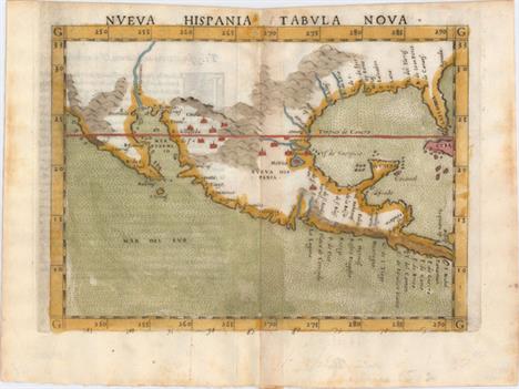
Los 314
Nueva Hispania Tabula Nova This is a foundation map in the cartography of the American Southwest, and a must for collectors of that region. It is an enlarged version of Gastaldi`s map of 1548 with the only notable change being the peninsular Yucatan. The legendary seven cities of Ciuola are prominently depicted and Mexico City is shown floating in a large lake. The place names along the upper Gulf Coast reveal the explorations of Pineda, Cabeza de Vaca and Moscosso. The Mississippi makes its appearance as the Rio de Spiritu Santo and the R. Tontonteanc flows in the vicinity of the Colorado River. Considered the earliest relatively obtainable map of Mexico and the American Southwest. This is the first state according to Burden. Latin text on verso.See also lot 737 for the first edition of Ruscelli`s atlas, La Geografia de Claudio Tolomeo Allessadrino A dark impression on watermarked paper with faint offsetting, light text show-through, and minor toning along centerfold. 7.3"" W x 9.5"" H Ruscelli, Girolamo 1564

Los 315
Hispania Nova This is one of the earliest maps of the American Southwest and Mexico, including the southern part of present-day Texas, here called Floridae Pars, with the Rio Grande, labeled R. de Palmas. The map concentrates on the Spanish area of influence and is one of nineteen regional maps of the Americas contained in Wytfliet`s atlas, which was the first devoted exclusively to the New World. Stipple engraved seas, calligraphy and a decorative title cartouche adorn the map. Fine impression and color on watermarked paper with two soft creases and light printer`s ink residue. 9"" W x 11.3"" H Wytfliet, Cornelis 1598
-
534325 Los(e)/Seite