![[Lot of 3] Map of the Deep River District North Carolina [and] Map of a Part of North Carolina Showing the Routes Connecting](http://lot-images.atgmedia.com/SR/36385/2906594/272-20145813217_468x382.jpg)

[Lot of 3] Map of the Deep River District North Carolina [and] Map of a Part of North Carolina Showing the Routes Connecting with Deep River District Constructing & Proposed [and] Report of the Secretary of the Navy This report was a result of a Senate resolution intended for ""expediency of establishing, at some point in the State, machine and workshops for the construction of engines, boilers, &c., &c., for naval vessels."" Captain Wilkes led this effort and determined that the Deep River District would be a favorable area for such operations. Included with the 29-page disbound report is one plate and the following two maps: A. Map of the Deep River District North Carolina (19.2 x 13.1""). Focused on the Deep River dividing the counties of Chatham and Moore, the map identifies the coal field and slate deposits following the river. Seven different geologic types are represented. On a detailed scale of 0.75"" per mile. Condition: Issued folding with moderate color offsetting and several fold separations that have been partially closed on verso with archival tape. B. Map of a Part of North Carolina Showing the Routes Connecting with Deep River District Constructing & Proposed (7.8 x 9.1""). This is a wider view of the area showing how the transportation network was connected to the Deep River District. Locates the Charlotte and Wilmington R.R., Wilmington and Raleigh R.R., as well as several proposed roads. Condition: Issued folding with light toning primarily along the folds and one fold separation. Report and plate are good with faint toning and a few minor edge tears. See description above for condition of maps. U.S. Navy Dept., 1858
534325 Preisdatenbank Los(e) gefunden, die Ihrer Suche entsprechen
534325 Lose gefunden, die zu Ihrer Suche passen. Abonnieren Sie die Preisdatenbank, um sofortigen Zugriff auf alle Dienstleistungen der Preisdatenbank zu haben.
Preisdatenbank abonnieren- Liste
- Galerie
-
534325 Los(e)/Seite
![[Map and Report] Map of Oklahoma Territory [with] Report of the Governor of Oklahoma This map was compiled from the correcte](http://lot-images.atgmedia.com/SR/36385/2906594/276-20145813224_468x382.jpg)
[Map and Report] Map of Oklahoma Territory [with] Report of the Governor of Oklahoma This map was compiled from the corrected map of the General Land Office 1898 and from data on file in the territorial office under the direction of Harry King, Chief of Drafting. It is an attractive map with great attention paid to detail, including railroads constructed and proposed, as well as roads and trails. The map covers present-day western Oklahoma with the panhandle, but only the western portion of what was then Indian Territory is shown. Indian reservations within the territory are shown, including the Wichitas, Kiowas, Comanches and Apaches. Land Offices are located at Woodward, Alva, Enid, Perry, Guthrie, Kingfisher, Ft. Reno, Oklahoma City, Mangum and Lawton. The map is still bound into the original report which includes 26 plates related to the development of the territory (key buildings, agriculture, forest reserves) and 2 smaller folding maps showing average precipitation and temperature. 8vo, 133 pp. in original clay colored wrappers. Condition code is for the maps, plates and text which are all clean, bright and nearly flawless. Wrappers show only very light wear with a few cracks along the spine and a couple of small chips. 14.4 W x 21.9 H General Land Office, 1901
![[Lot of 2] A New Map of Pennsylvania with Its Canals, Rail-Roads &c. [and] Philadelphia A. A New Map of Pennsylvania wit](http://lot-images.atgmedia.com/SR/36385/2906594/279-20145813228_468x382.jpg)
[Lot of 2] A New Map of Pennsylvania with Its Canals, Rail-Roads &c. [and] Philadelphia A. A New Map of Pennsylvania with Its Canals, Rail-Roads &c., dated 1850 (14.3 x 11.6""). A very handsome map with good detail throughout locating numerous towns and villages, rivers, canals, and railroads. Tables give the steamboat routes between Philadelphia to New York via Trenton, New York via Bordertown, and Baltimore via New Castle, and the route between Pittsburgh and Louisville. Also included are profile views along the Pennsylvania Canal and another along the Columbia Railroad. Decorative borders.B. Philadelphia, circa 1850 (12.8 x 15.8""). This nice mid-19th century plan of the City of Brotherly Love is divided into wards as indicated in a key at bottom. An extensive index table at right lists banks, churches, hotels, and public buildings. Original color with a few faint spots within the image and toning in the blank margins. The Philadelphia map has a couple minute worm holes that are only visible when held up to light. Thomas, Cowperthwait & Co., 1850

Texas A historically interesting county map of Texas showing good detail. A table provides a key to the symbols used to indicate towns, post offices, stage roads and list names of 65 counties. Of particular note is the identification in outline color of the Gebiet des Texas Verins with the route from the port of Indianola to the German settlements. Over half of the state is unorganized and mostly blank but it does list Indian tribes and other place names, e.g. White Sand Hills, Flatrock Ponds, Castle Mountains, Horsehead Crossing, etc. Finely engraved with delicate outline coloring, minor offsetting, just a few edge tears confined to the blank margins, and light toning along sheet edges. 8.3 W x 10.5 H Lange, Henry 1854

Carte du Texas pour les Missions et Voyages Scarce map of Texas based on Jacob de Cordova`s 1849 depiction showing the state west to the Pecos, here labeled R. Puerco, just north of the Rio Grande. Even though published in 1857, this French map illustrates Texas after it became the 28th state in 1845, but before the Compromise of 1850, when the present boundaries were established. There were four empresario grant type colonies established during the Republic of Texas period, one being the Fisher and Miller Colony, shown here north of Fredricksburg. The other three that are no longer noted on this map were Peters` Colony, Castro`s Colony and Mercer`s Colony. These types of colonies were changed to be more in order with regular US land grants. West Texas is noted as being the Solitudes habitees par les Comanches. This map illustrates the travels of Abbe Emmanuel Domenech in Texas; first in 1846-50, and then again in 1851-2. Domenech was the first Catholic priest to be ordained in Texas and was charged with the establishment of the Catholic hierarchy in Texas, amid the tensions of the boundary disputes with Mexico. On his second journey he based himself in Brownsville and visited neighboring places in Texas and Mexico. The tracks of his missionary activities are shown in orange on the map. This map was engraved by Erhard and published by Fevrier. It is an unusual and important map in the history of the state of Texas from the first edition of Domenech`s Journal. Issued folding with a 1.5"" binding tear at right that has been closed on verso with archival tape and mat burn confined to the blank margins and on verso. There are some light pen marks in the image. 17.8 W x 13.8 H Domenech, Emmanuel 1857

Johnson`s New Map of the State of Texas Large, handsome map with county development mostly in eastern Texas and only the three large western counties of El Paso, Presidio, and Bexar in the west. The panhandle, noted as the El Llano Estacado or The Staked Plain (Elevated Table Land, without Wood or Water), includes a large section that is unorganized. Nice depiction of the wagon roads, many named, with several completed railroads including the Houston & Guaymas R.R. Insets include Plan of Sabine Lake, Plan of the Northern part of Texas, and Plan of Galveston Bay. Decorative scrollwork border. Original color with minor offsetting and light toning primarily along the sheet`s edges. 16.7 W x 24.5 H Johnson & Ward, 1864
![[Lot of 2 with Same Title] County Map of the State of Texas Showing Also Portions of the Adjoining States and Territories Th](http://lot-images.atgmedia.com/SR/36385/2906594/294-20145813255_468x382.jpg)
[Lot of 2 with Same Title] County Map of the State of Texas Showing Also Portions of the Adjoining States and Territories This lot includes two double-page maps of Texas showing the growth of the state over a nine-year period. The maps present an excellent view of the county development with only the large regions of West Texas yet to be organized. Galvestons role as a main port of entry is obvious as it is depicted in a large inset. The Llano Estacado, or Staked Plain, is shown extending from the New Mexico Territory through the Texas panhandle. In the later map, the railroad network has extended its reach to El Paso and Laredo. A. County Map of the State of Texas Showing Also Portions of the Adjoining States and Territories, by Samuel Augustus Mitchell, dated 1879. Condition: Original color with a 2"" wide faint damp stain along the centerfold with light toning along the sheet edges. (B) B. County Map of the State of Texas Showing Also Portions of the Adjoining States and Territories, by William M. Bradley & Bros., dated 1887. Condition: Attractive original color with just a few tiny edge tears confined to the blank margins. (A) See description above. 14.4 W x 21.3 H 1879-87

Map Showing the Route of the Arkansas Regiment from Shreveport La. to San Antonio de Bexar Texas Uncommon map covering east-central Texas from Shreveport on the Red River to San Antonio. The Old San Antonio and Nacogdoches Road is prominently shown. This fascinating map locates several very early settlements including Douglas, Nacogdoches, Crockett, Robbins` Ferry, Washington, Independence, Bastrop, Houston, Liberty, Austin, Saguin, and, of course San Antonio de Bexar. Good detail of the watershed delineates the flow of the Guadalupe, San Marcos, Colorado, Brazos and Sabine Rivers. Also locates several tributaries including the San Saba, Pecan, San Andres, Bosque, and Argentina Rivers, and the creeks of Brushy, Palo Pinto, Peach, Cibolo, Saloda, Lavaca, Village, Alabama, and Bidais. This map was among the maps submitted to Congress to illuminate the U.S. Army`s first explorations in Texas, and accompanied Capt. G.W. Hughes ""Memoir descriptive of the March of a Division of the US Army under the command of BGen. J.E. Wool from San Antonio in Texas to Saltillo in Mexico."" Issued folding with a narrow bottom margin and some light, extraneous creasing at left. 11.6 W x 17.2 H U.S. Government, 1846-50

Birds Eye View of Bennington & Bennington Centre This attractive bird`s-eye view depicts this small city located in southern Vermont. Very detailed, individual buildings are displayed and city streets named. A key at bottom lists 26 important buildings in Bennington and 12 in Bennington Centre (the top portion of the image) which is bisected by a passing train on the Lebanon Springs Railroad. The view is decorated by a vignette of the ""Graded School Building"" at lower left. Published by J.J. Stoner in Madison, Wisconsin and lithographed by Shober & Carqueville in Chicago. Backed in heavy paper to reinforce and repair several small edge tears and cracks that are mostly confined to the blank margins except for one tear that just touches the neatline at right and two tears that enter the image 1"" at top and 2"" at left. Light toning. 21.9 W x 24 H Stoner, J. J. 1877

The Famous Hysterical Map of the Yellowstone Park Including a Few Minor? Changes This graphic map of Yellowstone National Park was ""hatched & scratched"" by Jolly Lindgren. It depicts the park in a light-hearted manner, with a number of silly visual puns, including hot springs drawn as coils radiating sizzle lines, a belching cabin to mark Soda Butte, a pool table standing in for Congress Pool, and a holdup bear appearing as a bear with a pistol. Old Faithful sings, ""I`m Forever Blowing Bubbles,"" while Folsom Peak has a jail cell on top. Lindgren also inserts jokey asides, such as a parenthetical ""Are Ya Hurt?"" beneath Gibbon Falls and ""Hell for Certain"" under Brimstone Basin. The Lindgren brothers of Spokane, Washington, specialized in humorous maps of state parks. An alternate title surrounds the map: A Hysterical Map of the Yellowstone Park with Apologies to the Park Smileage Guaranteed. There is some toning evident around the sheet`s edges and one short edge tear at right that does not enter into the neatline. 16.6 W x 16.5 H 1936

Map of the United States and Texas, Designed to Accompany Smith`s Geography for Schools This great school atlas map with early territorial borders in the West features the Independent Republic of Texas with Austin shown as the capital by a large star. The Oregon Territory covers the northwest and extends well into Canada. The huge Indian Territory lies north of Texas and extends to the Mandan Territory, which in turn goes to the border with Canada. Iowa Territory is in a rare configuration, stretching from Missouri to the Canadian border and bounded east and west by the Mississippi and Missouri rivers. The population is annotated for the states and Texas. The large inset at lower left is a detailed ""Map of Mexico and Guatimala"" and also shows the Republic of Texas, and the Spanish holdings in North America. Drawn and engraved by Stiles, Sherman & Smith. There is a centerfold separation confined to the bottom blank margin that has been closed on verso with archival tape, and several tiny worm holes, only visible when held up to light. 10.4 W x 17.5 H Burgess, Daniel 1839

The United States of Mexico This map shows Mexico the year after Texas became independent, and was issued a few short years after the first edition published in 1835. The small Texas configuration is prominently shown, including the towns of San Antonio and San Felippe de Austin. Little Rock, here labeled Arkopolis, is identified as well as Sante Fe, Albuquerque and Taos. The map extends south from New California to the Yucatan with a large inset entitled Guatemala or the United Provinces of Central America. Original outline color with light toning and just a few tiny spots of foxing. Tape remnants (removed) in top and bottom blank margins, away from the map image. 12.1 W x 10.6 H Burr, David H. 1837

Granata Nova et California This is the first printed map to focus on California and the American Southwest, from the first atlas devoted entirely to maps of the Americas. Wytfliet`s work was referred to as a continuation of Ptolemy, despite the fact that there was little connection with Ptolemy except for his name on the title page. Wytfliet compiled his atlas using multiple published sources, including Ramusio, Hakluyt and De Bry. The basis of this map is taken from Petrus Plancius` influential world map of 1592, including the error in naming the Tropicus Capricorni instead of the correct Tropic of Cancer. The most notable feature of the map is the location of the legendary seven cities of Cibola, Septem civitatum Patria, shown surrounding a lake, out of which flows a river that empties into the Mar Vermeio or Gulf of California. The information on the map is from Spanish sources including the narrative of Fray Marco de Niza in 1539 and the account of a rescue party led by Antonio de Espego in 1582. A very attractive map with a strapwork title cartouche and fully engraved seas. A fine impression on watermarked paper with light toning along centerfold. Paper is very supple and in excellent condition. 9.1 W x 11.4 H Wytfliet, Cornelis 1597

L`Ancien et le Nouveau Mexique, avec la Floride et la Basse Louisiane, Partie Occidentale This handsome map covers the region of present day southern California, Arizona, New Mexico, Texas and Mexico. Excellent detail, particularly of the Jesuit missions in Mexico and the Southwest, and of the numerous Indian tribes. The map locates San Diego, Santa Fe, Taos, Acapulco, Cabo St. Lucas and many towns along the Sea of Cortez and Baja Peninsula. Six distance scales at lower right. On watermarked paper with light offsetting. 13.5 W x 9.3 H Bonne, Rigobert 1780

Mexico & Guatemala This map of the southwest shows Texas as still a part of Mexico with Austins Colony noted. Sonora extends north into present-day Utah and is wedged between New Mexico and Upper California. The rivers Timpanogos and San Buenaventura run straight through the Great Basin into the Pacific. Insets include the Valley of Mexico and Guatemala. The map presents a great picture of the region prior to Texas declaring its independence. Original color with some light toning along the sheet edges, away from the map image. 11.7 W x 14.7 H Tanner, Henry Schenck 1834

Mexico This is an attractive representation of the present-day southwestern United States, Texas and Mexico. The map depicts the new state of Texas in its stovepipe configuration, bound by the Rio Grande on its western border. In Upper or New California, there is an American Fur Co. Depot on the eastern shore of L. Youta or Salt L.. The Great Spanish Road is shown from the Red River to Santa Fe, and then heading south through the length of Mexico. The map continues into Central America in an inset of Guatimala. Original outline color with light toning along the sheet edges, away from map image. Remnants of hinge tape on verso. 10.3 W x 14.5 H Hall, Sidney 1846

Central America II. Including Texas, California and the Northern States of Mexico This excellent map covers the southwestern United States subsequent to Mexico losing the region in the Mexican/American War. Texas is shown at its largest extent with the panhandle extending well north up to Spanish Peaks. All of the Southwest and California are here noted as ""Nueva or Upper California."" Charles Fremonts first expedition up the Oregon Trail and through the Sierra Nevada is traced and there are several notations in the Great Interior Basin of California from that important exploration. Lake Tahoe makes an early appearance as Mountain L. The Great Spanish Track from Pueblo de los Angelos to Santa Fe is also noted. There is great detail throughout including forts, Indian tribes, and numerous interesting notations. This is an updated version of the map first issued in 1842; engraved by J. & C. Walker and published by Charles Knight. Original color with light toning along the edges of the sheet. 12.5 W x 15.5 H SDUK Society for the Diffusion of Useful Knowledge, 1849

Mexico, California and Texas This is the second, and most desirable, state of this fine steel-engraved map that was issued during a time of great transition in the region. After gold was discovered in California, the plate was re-engraved to include a vignette of gold panning and to locate the gold regions of California which are delineated through hand coloring. Texas is shown with its original state borders that include much of present-day New Mexico and extend into Colorado. Two other vignettes show Mexican peasantry and the ancient Mayan ruins at Uxmal. The very decorative border incorporates native plants of the region. Map drawn and engraved by John Rapkin, vignettes drawn by H. Warren and engraved by J. Rogers. Original outline color with light toning along the centerfold, a few tiny spots, and minor soiling along the sheet edges. 10 W x 13 H Tallis, John 1850

Messico o Nuova Spagna Dove si Possono Rintracciare i Movimenti di Cortes... This is an Italian edition of Kitchin`s map of the American Southwest and Mexico. California is labeled ""Nuovo Albione"" (New Albion) with no detail outside of a few coastal place names. The region of present-day Arizona and New Mexico is well delineated with numerous Indian villages and the locations of missions. The area from New Mexico to Louisiana is named ""Grande Spazio di Terra Incognita"" (Great Space of Land Unknown). The small Texas settlement of Cenis is near the ""Nuovo Regno ni Leon"" (New Kingdom of Leon). An inset shows Mexico City on the large Lake of Mexico. Finely engraved with a decorative title cartouche and compass rose. Issued folding on watermarked paper with light offsetting and a binding trim and short binding tear confined to the lower right blank margin. 11.2 W x 14.9 H Kitchin, Thomas 1795

Preliminary Survey of the Entrance to the Rio Grande Texas This represents the only USCS charting of the area. It provides a detailed view of the first few miles of this great river. At the mouth of the river is the village of Bagdad, and an observatory is located on the opposite shore. Nice topographical detail and many soundings given, including in the Rio Grande itself. Drawn by W.E. Greenwell and engraved by C.A. Knight and F.W. Benner. Issued folding with light toning along folds and a binding trim at left with about 4"" of neatline missing. A few fold separations have been closed on verso with archival tape, and a small hole appears at the fold intersection. 13.6 W x 14.5 H U.S. Coast Survey, 1854

Nova Hispania, et Nova Galicia Decorative map of the central and western coastal regions of Mexico, based on Ortelius. Mexico City is situated on a large lake below the elaborate title cartouche featuring the Royal Spanish Arms. Several gold and silver mines are located in the central region. A galleon and sea monster ornament the Pacific and armadillos walk across the scale of miles cartouche. This is a superlative example of Dutch cartography and a great example of the similarity between the work of Jansson and Blaeu. Here Jansson`s plate features a ship and sea monster with calligraphy in the Pacific, whereas Blaeu`s map lacks the calligraphy and embellished the area with two ships and a compass rose. Latin text on verso. Expertly remargined on all sides with light toning along centerfold and a separation at bottom that has been professionally repaired. There are three tiny holes just inside border at top left, one of which has been infilled. 13.7 W x 18.9 H Jansson, Jan 1638

An Accurate Map of the West Indies. Exhibiting Not Only All the Islands Possess`d by the English, French, Spaniards & Dutch, but Also All the Towns and Settlements on the Continent of America Adjacent Thereto A handsome and fully engraved map covering the Southern U.S., Central America, the West Indies, and northern South America. It presents a fascinating configuration of Florida as wedge-shaped with a flat bottom. The chart is covered with interesting notations concerning the history of the region, territorial claims, and the Spanish gold fleet. The seas are fully engraved with ruled lines and an extensive array of trade-wind arrows. Compass rose and block-style title cartouche. A long notation gives sailing directions from Europe, Africa, Florida to Jamaica, and from Jamaica to the Windward Passage. It was published in the January 1740 issue of the Gentleman`s Magazine. Issued folding, now flat. The margins are trimmed close to the neatline at top, left, and right, with the right margin extended to better accommodate framing. Two tiny holes that are only visible when held to light appear along one fold. 11.6 W x 15.2 H Bowen, Emanuel 1740

Charte von Westindien und einem Theile von Sudamerica Map of the Gulf of Mexico covering the region from Florida to northern South America. The map shows good detail of topography, the river systems and place names. A key at bottom identifies the possessions of the United States, Spanish, French, English, Dutch, Germans and Swedes. The map was issued by the Kunste un Industrie Compoires, and engraved by Kuhn. Watermarked paper with one small rust spot, light soiling, and narrow margins at left and right, as issued. 18.7 W x 27.3 H 1809

Pas-kaart van de Zuyd-Kust van Espanjola met de Zee Kust van Nuevo Reyne de Granada This sea chart depicts the southern portion of Hispaniola, showing detailed navigational information along the coastline near Santo Domingo. At bottom is the northern coast of South America and the islands of Aruba and Curacao. The map is decorated by a sailing ship, two compass roses and radiating rhumb lines. A nice impression with a narrow top margin, light toning along the centerfold, and some color stains. 20.4 W x 23.2 H Keulen/Vooght, 1680
![[Lot of 2] I. d`Hispaniola et P. Rico [and] Le Plan de l`Isle de St. Jan de Pto. Rico est dans la Page Precedente Chisree 31](http://lot-images.atgmedia.com/SR/36385/2906594/349-20145813438_468x382.jpg)
[Lot of 2] I. d`Hispaniola et P. Rico [and] Le Plan de l`Isle de St. Jan de Pto. Rico est dans la Page Precedente Chisree 319 ... de la Ville de San-Domingo ou de St. Dominique... This charming lot of miniature maps provides a closer look of the islands of Puerto Rico and Hispaniola. Size varies slightly. French text on versos.A. I. d`Hispaniola et P. Rico. Both islands are featured on this first sheet, surrounded by smaller satellite islands and battling war ships. A handful of cities are located, including San Juan in Puerto Rico and Santo Domingo in Hispaniola, with Hispaniola divided into five regions. The title is enclosed in a banner. Condition: Faint show-through of text on verso and light toning in the blank margins. (A)B. Le Plan de l`Isle de St. Jan de Pto. Rico est dans la Page Precedente Chisree 319 ... de la Ville de San-Domingo ou de St. Dominique.... The second sheet is a bird`s-eye view of the city of Santo Domingo, now the capital of the Dominican Republic and the largest city in the Caribbean. There are two ships in the foreground with several cathedrals, the port, and the city`s fortifications detailed in the view. A drape-style title cartouche hangs above the city. Condition: Light show-through of text on verso with a small hole and some soiling in the blank margins. (B+) See description above. 5.8 W x 3.9 H Mallet, Alain Manesson 1683
![[Lot of 2] An Indian Cacique of the Island of Cuba, Addressing Columbus Concerning a Future State A. An Indian Cacique of th](http://lot-images.atgmedia.com/SR/36385/2906594/352-20145813445_468x382.jpg)
[Lot of 2] An Indian Cacique of the Island of Cuba, Addressing Columbus Concerning a Future State A. An Indian Cacique of the Island of Cuba, Addressing Columbus Concerning a Future State, by Bryan Edwards, from Cacique of the Island of Cuba, Addressing Columbus Concerning a Future State, dated 1794 (6.8 x 7.9""). This striking print depicts a meeting between Christopher Columbus and a cacique (Taino for chief) and his people. Columbus is backed by a priest and some soldiers. The natives appear to have an offering of fruit, including pineapples. The detail is such that one can see among the natives expressions of warmth, fascination, and trepidation. Drawn by Benjamin West, engraved by Francesco Bartolozzi, and published by John Stockdale. Condition: On watermarked paper. B. A Sachem Exhorting the Indians to War, by Fenning/Collyer, from A New System of Geography or A General Description of the World, circa 1765 (5.9 x 8.1""). This dramatic print illustrates a sachem (chief) calling for war in the middle of a circle of his people. The scene takes place in the northeastern United States, most likely in Massachusetts. Drawn by Wale and engraved by Hall. Condition: On watermarked paper with light soiling confined to the ample blank margins. See description above. 7.9 W x 6.8 H 1765-94
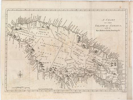
A Chart of the Island of Jamaica, with Its Bays, Harbours, Rocks, Soundings, &c. This striking map of Jamaica is divided into the counties of Cornwall, Middlesex, and Surry and subdivided further into a number of parishes. The map is teeming with detail along the coasts, with a myriad of bays, rivers, harbors, cliffs, coves, and the like named. In the water, reefs, anchorages, and soundings are shown. There is considerably less detail inland, although many mountains are depicted, including the Blue Mountains. A compass rose capped with a fleur-de-lis appears at bottom left. Engraved by John Lodge. This lot comes with the related four page article titled ""Discovery and Settlement of Jamaica..."" from the August 1780 issue of Political Magazine. Issued folding, now flattened, on watermarked paper with light offsetting and a couple fold separations that have been closed on verso with archival materials. There is a binding trim at right that has been replaced with old paper and an associated 2"" binding tear that has been closed with archival materials. 10.2 W x 15 H Bew, John 1780

Carte des Antilles Francoises et des Isles Voisines Dressee sur des Memoires Manuscrits This is Chatelain`s version of Delisle`s map of the Lesser Antilles that includes the interesting cartographic error of an upside-down Grenada. It extends from Guadeloupe to Grenada and includes Barbados. Numerous place names are shown, as are the locations of forts, churches, rivers, towns and villages. French text describes the European discovery and history of the islands. A dark impression issued folding on a watermarked sheet with light offsetting and a binding trim that extends to the neatline at top left. There are some chips and short edge tears along the left edge of the sheet, well away from image. 18.9 W x 12.9 H Chatelain, Henry Abraham 1719

Carte de de l`Isle St. Christophe This lovely map of St. Kitts is fully engraved with mountains, rivers, lakes, and towns. The island has twelve quarters and parishes, which are sometimes indicated by hand coloring, but not on this example. In the center of the island a note on the mountain Mont Misery locates Mines de Souffre. Grande Saline, Ville de la Basse Terre, forts, churches and more are identified. Decorated with baroque-style title and scale of miles cartouches and a fleur-de-lys, all fully colored. A nice bright sheet with light offsetting. 7.5 W x 12 H Bellin, Jacques Nicolas 1763

A Map of Terra Firma. Guiana and the Antilles Islands This small map covers all of the West Indies and South America, north of the equator. In Guyana, the large, legendary Prime Lake is noted on the Equator, with the mythical city of gold, Manoa o el Dorado named on its shores. The tip of Florida is labeled Part of Louisiana and the Great Bahama Bank (Bahama Shoald) is clearly indicated. Published in London in Thomas Salmon`s Modern History: or the Present State of All Nations. Toned with light offsetting from an opposing text page. 7.1 W x 10.2 H Moll, Herman 1745
Carta Particolare del` Peru che Comincia con il Capo di Guanapo e Finisce con il` C. S. Francesco An elegant sea chart of the coastline of Ecuador and northern Peru, extending just south of Trujillo. Numerous place names are shown along the coast, as well as anchorages, soundings, and shoals. The equator is featured prominently towards the top of the chart, and Quito is depicted inland. The chart is embellished with Dudley`s trademark calligraphic style, a strapwork title cartouche, a large compass rose, and a sailing ship. This is the second edition with Lo. 6. added to the title cartouche. Printed on two sheets, joined as issued.Robert Dudley was the first Englishman to produce a sea atlas, Dell Arcano del Mare (Secrets of the Sea). A skilled mathematician and navigator, Dudley was exiled from England and settled in Florence where his atlas was published. He introduced a totally new style for sea charts in the atlas with only lines of latitude and longitude and no rhumb lines. The charts were meticulously compiled from original sources and were both scientific and accurate for the time. This important atlas was the first sea atlas of the whole world; the first to use Mercator`s projection throughout; the earliest to show the prevailing winds, currents and magnetic deviation; and the first to expound the advantages of Great Circle Sailing. In an introductory leaf found in one copy in the British Library, the engraver states that he worked on the plates in seclusion for twelve years in an obscure Tuscan village, using no less than 5,000 pounds of copper for the printing plates. It was only issued in two editions and the maps are rarely seen on the market. Issued folding on watermarked paper with light toning along joint and in right blank margin. 18.3 W x 28.8 H Dudley, Robert (Sir) 1661

Terra Firma et Novum Regnum Granatense et Popayan Splendid map of the Isthmus of Panama and northwestern South America including most of present day Colombia and part of Venezuela. The map is based on the cartography of Hessel Gerritsz and formed one of the prototypes for South American cartography throughout the rest of the century. Jodocus Hondius engraved the map. After his death, Blaeu obtained the copper plate, added his imprint, and issued the map in a number of atlases. Two cartouches and a pair of compass roses dramatically decorate this map. French text on verso, published between 1638-43. Attractive color on watermarked paper with a hint of toning and light damp stains confined to far blank margins. 15 W x 19.3 H Hondius/Blaeu, 1638

Brasil Nuova Tavola This is one of the earliest maps of Brazil that is available to collectors. Though most of the maps in Ruscelli`s edition of Ptolemy are enlarged re-engravings of those found in the Gastaldi edition of 1548, there are four important, original maps including this one of Brazil. The map is oriented with north to the right. There are some coastal place names, but very little interior detail other than scattered rivers, mountains, forests and a large volcano. The interior is labeled Terra non Descoperta and there is a notation referring to cannibals (Gli indi natij di questi paesi mangiano carne humana). In later editions this notation is replaced with an illustration of cannibalism. This is the first state with the platemark running through the top margin. Latin text on verso.See also lot 732 for a complete first edition of Ruscelli`s Geographia. Light offsetting and tiny mildew stains in the image. 7.3 W x 10 H Ruscelli, Girolamo 1561

Brasilia Charming miniature map of Brazil with numerous place names along the coastline. A large spurious Lacus Eupama dominates the interior. Decorative title cartouche. Latin text on verso. This is from the first edition, with a mis-print of the title above the map (Descriptio Regni Chili). A dark impression and attractive color on watermarked paper with light toning. 3.9 W x 5.2 H Hondius/Bertius, 1618

Le Paraguay Subdivise en Ses Principales Parties, Suivant les Dernieres Relaons Boldly engraved map of the region of present day Paraguay, Uruguay, northern Argentina and southern Brazil. The Rio de la Plata is the main feature of the map along with the mountains and volcanoes of the Cordillera de los Andes. A drape-style title cartouche adorns the map. Engraved by Antoine de Winter. Watermarked paper with light printer`s ink residue. Narrow top and bottom margins, as issued. 8.2 W x 10.9 H Sanson, Nicolas 1683

Le Paraguay Tire des Relations les Plus Recentes Boldly engraved map of the region of present day Paraguay, Uruguay, northern Argentina, and parts of Chile and Brazil. The Rio de la Plata is the main feature of the map, which extends north to the mythical Lago de los Xarayes. The mountains and volcanoes of the Cordillera de los Andes are also prominently shown. There is good detail of topography, missions and villages. The decorative title cartouche is adorned with two female figures, fruit and flowers. On watermarked paper with original outline color in the map and later coloring in the cartouche. Light toning along sheet edges. 16.1 W x 21.5 H Sanson, Guillaume 1668

Cusco, Regni Peru in Novo Orbe Caput This is one of only two New World cities depicted in the Civitatis Orbis Terrarum. It shows Cusco at the time of the Spanish conquest. The city is very orderly, laid out in a rectangular grid and surrounded by impressive walled fortifications. Native and Spanish figures fill the foreground and the Inca king is being carried aloft on a covered throne. Trimmed from a folio sheet that also contained a plan of Mexico City. Light, extraneous creasing at far left, and remargined at left to accommodate framing. 10.6 W x 9.4 H Braun & Hogenberg, 1572

Carte Reduite du Detroit de Magellan Dressee sur les Journaux des Navigateurs Uncommon detailed chart of the Strait of Magellan locating harbors, islands, capes and bays from Cap des Vierges to Cap de la Victoire. The rococo-style cartouche includes a lettered reference table for anchorages, bays, and harbors in the vicinity of Isle de Louis le Grand at the mid-point of the strait. A dark impression on watermarked paper with a hit of offsetting, a light damp stain that enters border at bottom left, and an abrasion in border at top left. 7.5 W x 13.6 H Bellin, Jacques Nicolas 1753

Carta Particolare del Mare di Ethiopia con l`Isola di S. Elena e Parte della Costa d`Affrica Carta VIIII This elegant sea chart is crisply engraved in the sparse Florentine style with superb calligraphy throughout. The map covers the islands in the South Atlantic centering on St. Helena and extending west to Ascension Island. The map extends to include two stretches of the African coastline, including portions of present-day Congo, Angola and Namibia. Sailing ships, a compass rose and a strapwork title cartouche embellish the chart. Short navigational notes are included throughout. This is the first state. Printed on two sheets, joined as issued.Robert Dudley was the first Englishman to produce a sea atlas, Dell Arcano del Mare (Secrets of the Sea). A skilled mathematician and navigator, Dudley was exiled from England and settled in Florence where his atlas was published. He introduced a totally new style for sea charts in the atlas with only lines of latitude and longitude and no rhumb lines. The charts were meticulously compiled from original sources and were both scientific and accurate for the time. This important atlas was the first sea atlas of the whole world; the first to use Mercator`s projection throughout; the earliest to show the prevailing winds, currents and magnetic deviation; and the first to expound the advantages of Great Circle Sailing. In an introductory leaf found in one copy in the British Library, the engraver states that he worked on the plates in seclusion for twelve years in an obscure Tuscan village, using no less than 5,000 pounds of copper for the printing plates. It was only issued in two editions and the maps are rarely seen on the market. A nice dark impression with light printer`s ink residue on bright, watermarked paper. A very fine example with just a touch of marginal soiling. 19.3 W x 30.3 H Dudley, Robert (Sir) 1646

Terra Nova, ac Maris Tractus circa Novam Franciam, Angliam, Belgium, Venezuelam Novam Andalusiam, Guianam et Brasiliam - Terra Neuf, en de Custen van Nieu Vranckryck, Nieu Engeland, Nieu Nederland, Nieu Andalusia, Guiana en Venezuela Magnificent sea chart of the western Atlantic Ocean showing the coastlines of North America from Cape Charles, Maryland to Newfoundland, and the West Indies to the northern coast of Brazil. The chart is based on that of Theunis Jacobsz, circa 1650, with few changes except for an improved (although still rudimentary) depiction of the Chesapeake Bay. Oriented by two compass roses with north to the left; the Azores and Cape Verde Islands are at the top of the map. It is richly decorated with two large cartouches with the title in Latin and Dutch. The central cartouche is surrounded by Mercury, a native riding an alligator, mermen and sea monsters. The corner cartouche with Dutch title features figures of explorers, natives, and exotic animals, including an armadillo. In the sea are sailing ships, including a raging sea battle, rhumb lines and two compass roses. This is the first state, with page 22 at top right.First published circa 1675, de Wit`s sea atlas, Orbis Maritimus ofte Zee Atlas, contained 27 charts from the North Pole to North and South America. The charts all appear to have been engraved by Romain de Hooghe and are splendid examples of Dutch marine works. The atlas was reprinted with amendments by Louis Renard in 1715, by Reinier and Josua Ottens in 1739 and 1745, and finally by the widow of van Keulen in 1802. A nice, dark impression with a few small spots of printer`s ink residue. There are professional repairs to a centerfold separation that enters 1"" into map at bottom, a 1"" separation along the upper centerfold only visible when held to light, a small hole and tear in Brazil, and a number of small tears and chips in blank margins. 19 W x 22.2 H Wit, Frederick de 1675

Carte du Groenland This finely engraved chart of Greenland and Iceland shows the Davis Strait and a portion of Baffin Island in Northeast Canada. Many harbors are located on Greenland`s coast with inlets and bays. Three channels are marked with dotted lines apparently demarking the three islands that were thought to make up the tip of Greenland. A small hint of the northern coast of the fictitious Frisland appears as well. On watermarked paper with a few minor spots and light toning. 7.6 W x 10 H Laurent, J. 1770
![[Lot of 3] Groenland [and] Novae Zemlae Delineatio [and] Delineatio Freti Vaigats This matched set of 3 miniature maps are f](http://lot-images.atgmedia.com/SR/36385/2906594/411-20145813631_468x382.jpg)
[Lot of 3] Groenland [and] Novae Zemlae Delineatio [and] Delineatio Freti Vaigats This matched set of 3 miniature maps are from Bertius` geographical treatise. Each map is beautifully engraved with a strapwork title cartouche and fully engraved seas. The majority of the maps for Bertius` geographical treatise were engraved by Jodocus Hondius Jr. after Mercator. French text on verso. Size varies slightly.A. Groenland. This handsome miniature map is one of the first maps to focus on Greenland. The island is shown as a narrow island with a central mountain range. Across the Fretum Davis is C. Bedford. Iceland is also shown with an erupting volcano.B. Novae Zemlae Delineatio. This charming miniature map shows the parts of Novaya Zemlya that had been discovered by western Europeans during their search for a northern passage to Asia. The first visit was by Hugh Willoughby in 1553. Then in 1596, Willem Barents rounded the north point of Novaya Zemlya, and wintered on the east coast near the northern tip. The map shows the western coast and northern tip of Novaya Zemlya according to Barent`s reports, and is decorated with two sailing ships and a raft of penguins in the sea, with a decorative title cartouche and compass rose.C. Delineatio Freti Vaigats. This miniature map shows the straits between mainland Russia and Vaygach Island, an area that was discovered by western Europeans during their search for a northern passage to Asia. The first visit was by Hugh Willoughby in 1553. Then in 1596, Willem Barents rounded the north point of Novaya Zemlya, and wintered on the east coast near the northern tip. At the time Vaygach Island was thought to be a part of Novaya Zemlya. The map is decorated with a sailing ship, compass rose, spouting whale, and a nice title cartouche. Very light toning and marginal soiling. 3.8 W x 5.3 H Hondius/Bertius, 1616

Europa Recens Descripta This classic map of Europe is presented in the carte-de-figures style with vignettes on three sides. The upper frieze has nine bird`s-eye views of Amsterdam, Prague, Constantinople, Venice, Rome, Paris, London, Toledo and Lisbon. The side borders contain the costumes of the noblemen and women of ten European nations. The map is embellished with sailing ships, sea monsters, bears and Neptune riding a dolphin and holding his trident. A beautiful map produced at the height of the Golden Age of Dutch mapmaking; it was included in the first volume of Blaeu`s magnificent atlas. French text on verso, published between 1643-50. A dark impression with original color that has been partially refreshed, light printer`s ink residue at left, and an expertly repaired centerfold separation that enters 2"" into map at bottom. The right and left margins have been extended to accommodate framing. 16.3 W x 22.1 H Blaeu, Willem 1643

Europa Secundum Legitimas Projectionis Stereographicae Regulas et Juxta Recentissimas Observationes Aeque ac Relationes... Decorative map of Europe with good detail throughout. It is based upon Haas` stereographic horizontal projection, which was featured in his book on cartographic methodology. Large decorative cartouche features Europa, crowns, horse heads, putti and the figure of Fame with her trumpet. A handsome chart that extends to include Iceland, the Mediterranean, and part of Northern Africa. French title L`Europe dessinee Suivant les Regles... is in top margin. Light soiling with a few very minor repairs and creases along the centerfold. 18.7 W x 21.8 H Haas/Homann Heirs, 1743

Britannia Prout Divisa fuit Temporibus Anglo-Saxonum, Praesertim Durante Illorum Heptarchia Elaborate vignettes depicting kings and scenes from Saxon history flank this magnificent map of Britain. The scenes are identical in subject matter to those used by John Speed. However they are presented in the dramatic, Dutch miniature style. The left border contains portraits of the earliest kings, while the right one depicts later kings in the process of conversion to Christianity. Included is a scene of Ethelbert receiving instruction from Saint Augustine and another of Sebert re-consecrating the temples of Diana and Apollo, now St. Paul`s, London and St. Peters, Westminster. The map shows England, Scotland and Wales divided into the various Saxon kingdoms, each decorated with its coat-of-arms. A superb example of Dutch cartographic design and engraving. French text on verso, published between 1645-48. A fine impression with full original color, light even toning, and professional repairs to a few small holes confined to blank margins. There is a printer`s crease in the bottom right vignette. 16.3 W x 20.3 H Blaeu, Johannes 1645

Britannia Romana This handsome map shows the British Isles during the era of Roman rule. Iron Age tribes are located, as are numerous towns. Hadrian`s Wall is depicted and various associated forts are named. The title cartouche is emblazoned onto a shield. On watermarked paper with light offsetting and remnants of cello tape on verso and along the edges on recto. There is moderate toning that is mostly confined to the blank margins. 13.9 W x 16.9 H Morden, Robert 1695
![[Lot of 4] London to Birmingham by Buckingham and Banbury [and] [Untitled - Road map from Wendover to Caughton] [and] A Map](http://lot-images.atgmedia.com/SR/36385/2906594/427-2014581370_468x382.jpg)
[Lot of 4] London to Birmingham by Buckingham and Banbury [and] [Untitled - Road map from Wendover to Caughton] [and] A Map of Buckinghamshire North West from London [and] Buckinghamshire A. London to Birmingham by Buckingham and Banbury, by Carrington Bowles, from Paterson`s Itinerary, dated 1785, black and white (3.5 x 6.5""). The recto of this sheet contains a strip map from Tring through Aylesbury to Bicester. The verso shows a strip map from Chalfont St. Peter through Amersham and Aylesbury to Padbury, just a few miles south of Buckingham. In the bottom margin on both sides are keys identifying the proprietors of various locations on the maps. Condition: A fine impression on watermarked paper. (A+)B. [Untitled - Road map from Wendover to Caughton], by Owen & Bowen, from Britannica Depicta or Ogilby Improved, circa 1720, black and white (4 x 6.2""). This strip map depicts the road from Wendover through Alesbury, Buckingham, Banbury, and Stratford upon Avon, to Caughton. Notes regarding each of the towns along the map are included, and on verso is the coat of arms of Banbury. Condition: Watermarked paper with very light toning. (B+)C. A Map of Buckinghamshire North West from London, by Thomas Badeslade, from Chorographia Britanniae, dated 1742, hand color (5.9 x 5.8""). This miniature map depicts Buckinghamshire showing roads, towns, rivers, and topography. At left is information for each of the towns regarding the number of members they send to Parliament and days on which there are markets and fairs. Condition: Light toning with remnants of cello tape along edges of sheet on verso. (B+)D. Buckinghamshire, by Anonymous, circa 1720, hand color (4.1x 4.1""). This tiny map of Buckinghamshire shows towns and includes a triangular distance table. Condition: A few spots of foxing. (B+) See description above. 1720-85

To the Honourable Sr. Ralph Delaval Kt. Vice Admirall of the Red This Is Most Humbly Dedicated & Presented by Capt. Greenvile Collins Hydrographer to the King This elegant chart of the southeast coast of England spans from the Firth of Forth (here called Edinbrough Frith) down to Kent, and extends across the North Sea to show part of the coast of the Netherlands. There is little to no inland detail, but counties, towns, and cities, including a prominent London, are identified along the coasts. The chart shows good navigational detail, with soundings, fishing banks, shoals, and rocks depicted. A compass rose at the center of the chart orients north to the right and a coat-of-arms appears in England. Neptune and the allegorical female representation of Earth flank the decorative title/dedication cartouche.In 1681 Capt. Greenville Collins (fl.1669-1694) an officer in the Royal Navy was appointed by the Admiralty to make a complete survey of the coasts of Great Britain. Prior to this date the charts used by English mariners were copies of Dutch charts that had many inaccuracies. The task of surveying the entire coasts was formidable and took about 7 years, at the end of which only 46 surveys were finally used in an atlas titled ""Great Britain`s Coasting-Pilot Being a New and Exact Survey of the Sea-Coast of England,"" which was first published in 1693. There is light soiling, a few minute worm holes that are only visible when held up to light, and scattered foxing mostly concentrated in the blank margins. 17.6 W x 22.1 H Collins, Capt. Greenvile 1693
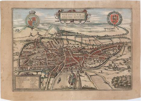
Nordovicum, Angliae Civitas This fine view of Norwich is based on William Cuningham`s plan of 1558. Viewed from the northwest, its situation on a bend in the River Wensum is shown surrounded by verdant farms and pastures. The Norman Cathedral of the Holy and Undivided Trinity is at the heart of the city and to the right, on top of a small hill, is the castle. In the center foreground of the picture are a man and woman in customary local dress. A key at lower left describes 21 sites including 11 gates into the city. The arms of England and the city arms flank the title cartouche. Latin text on verso. Old color on a toned sheet with light scattered foxing, a tiny wormhole near the centerfold, and one crack in cartouche at bottom left that has been archivally repaired. There are a few edge tears that have all been archivally repaired, only two of which touch the neatline at top. 11.5 W x 16.6 H Braun & Hogenberg, 1581

The Metropolitan Boroughs, as Defined by the Reform Bill The Electoral Reform Act of 1832 created the metropolitan boroughs of London as depicted on this finely drawn plan that extends from Tottenham in the north, West Ham in the east, south to Norwood and west to Kensington. The River Thames is depicted flowing through the center of London from Greenwich to Battersea, Wandsworth, and Fulham. At bottom left is an explanation of the boundary lines and a list of `liberties` - the name given to areas exempt from the jurisdiction of the country sheriff, being subject to a separate commission of the peace (in this case royal and governmental authorities). The upper corners are decorated with the arms of the City of London and the City of Westminster, both embellished with floral sprays. Issued folding with light offsetting concentrated in the lower half of the image and some short fold separations, most of which have been closed with archival materials. The sheet has been remargined at left to accommodate framing. 24 W x 19.6 H Dawson, Robert Kearsley 1832
![[Lot of 3] England and Wales [and] England [and] Engla Land, Sive ea Britanniae Pars, quae Citra Tuedam Fl. Saxonibus Subjec](http://lot-images.atgmedia.com/SR/36385/2906594/439-20145813723_468x382.jpg)
[Lot of 3] England and Wales [and] England [and] Engla Land, Sive ea Britanniae Pars, quae Citra Tuedam Fl. Saxonibus Subjecta Est An interesting lot of nineteenth century maps centered on England and Wales, each complete with towns and cities, political divisions, rivers, and topographical detail.A. England and Wales, by J. Dower, from A New General Atlas of Modern Geography..., circa 1854 (8.7 x 10.2""). Includes two keys, the first showing the markers used to signify railroads and cities by population, the second devoted to the color code used to delineate the various districts and counties. A picture chart running along the bottom of the sheet shows the height of several mountains and towns relative to sea level. Published by Orr & Company. Condition: Original color. (A)B. England, by John Walker, from Walker`s New Atlas, circa 1816 (7.1 x 8.3""). Engraved by Thomson. Condition: Issued folding, now flat. (A)C. Engla Land, Sive ea Britanniae Pars, quae Citra Tuedam Fl. Saxonibus Subjecta Est, by Aaron Arrowsmith, Jr., from Orbis Terrarum Veteribus Noti Descriptio..., dated 1828 (9.7 x 12.3""). Condition: Light offsetting from an opposing page of text, a spot of foxing at left, and marginal soiling. (B+) See description above. 1816-54

A New & Accurate Map of North Wales, Drawn from a Late Survey This detailed map details six historic counties in northern Wales, from Anglesey down to Montgomeryshire. Roads, castles, rivers, and bays are identified, and cities, rectories, vicarages, fairs, and borough and market towns are indicated by symbols explained in a key at top right. A decorative title cartouche adorns the bottom left corner. Issued folding on a slightly toned sheet with light offsetting and some soiling mostly concentrated just outside the neatline at left. 7.2 W x 9.3 H Anon., 1766
![[Lot of 2] Perth Kinross [and] Argyle This appealing pair of miniature maps focuses on Perth Kinross and Argyle, regions and](http://lot-images.atgmedia.com/SR/36385/2906594/446-20145813736_468x382.jpg)
[Lot of 2] Perth Kinross [and] Argyle This appealing pair of miniature maps focuses on Perth Kinross and Argyle, regions and former counties of Scotland. The Perth Kinross map is embedded in an elaborate illustration featuring a bolt of cloth, bird, waterfall, and fish (the area is known for its salmon and trout fishing). Within the map itself, towns, rivers, mountains, and a lake are identified. Engraved by Thierry. The Argyle map is surrounded by depictions of a waterfall, mallet, fishing net, sheep`s head, and bolts of cloth, and shows the string of islands that make up the region. Engraved by Migneret. Maps by Perrot are described by King as ""the most decorative miniature maps of the nineteenth century."" Size varies slightly. Each map has light scattered foxing. There are remnants of hinge tape on the verso of the Perth Kinross map. 4.3 W x 2.8 H Perrot, Aristide Michel 1823

Ireland This is a delicately engraved map of Ireland showing excellent detail of the provinces, towns, and cities as well as topography. The map is surrounded by lovely vignettes of St. Patrick`s Cathedral in Dublin, Limerick Castle, one of Ireland`s Holy Wells, Ross Castle on the Lake of Killarney, and the Round Tower in Wicklow. The beautifully engraved border is comprised of shamrocks, with a harp entwined in shamrocks at the bottom. Original outline color with light scattered foxing, faint soiling, and marginal toning. 13.7 W x 9.4 H Tallis, John 1850

A Plan of the River Lagon, and of the Intended Navigable Canal from Belfast to Loughneagh... This appealing map centers on the River Lagan and stretches from Lough Neagh to just northeast of Belfast. Various towns and cities, mills, bridges, and roads are shown. A chart at bottom right indicates the distance between various destinations in the area depicted. A compass rose orients the map with the north to the upper right hand corner. Issued folding with light offsetting. 6.8 W x 12.4 H Bowen, Emanuel 1778

This Chart of Kingsale Harbour Is Humbly Dedicated and Presented to the Right Honble Sr. Robert Southwell... This handsome chart focuses on a portion of County Cork in southwest Ireland, where the River Bandon meets the Bay of Old Head. The fishing village of Kinsale is prominently featured as a dense cluster of buildings in the shadow of Compass Hill. Across the River Bandon is an Old Fort, with a new, larger fort depicted down the river, past Summers Cove. Various other coves are located along the coast, as are sites of interest such as the lighthouse at Old Head, Fishing Pallace, Ruines of a Forte, and Lord Courcyes House. Within the water there are numerous soundings and hazards, as well as a compass rose capped with a fleur-de-lis that radiates rhumb lines and orients north to the lower right corner. Cannons and flags jut from an elaborate cartouche flanked by putti that encloses a dedication to Sir Robert Southwell. Engraved by J. Harris. In 1681 Capt. Greenville Collins (fl.1669-1694) an officer in the Royal Navy was appointed by the Admiralty to make a complete survey of the coasts of Great Britain. Prior to this date the charts used by English mariners were copies of Dutch charts that had many inaccuracies. The task of surveying the entire coasts was formidable and took about 7 years, at the end of which only 46 surveys were finally used in an atlas titled ""Great Britain`s Coasting-Pilot Being a New and Exact Survey of the Sea-Coast of England,"" which was first published in 1693. Nice impression and color with light soiling and a printer`s crease adjacent to the centerfold. There are remnants of hinge tape in the blank margins on recto. 17.6 W x 22.3 H Collins, Capt. Greenvile 1693
![[Lot of 3] Suecia et Norvegia ect. [and] Gotia [and] Thietmarsia This matched set of 3 miniature maps are from Bertius` geog](http://lot-images.atgmedia.com/SR/36385/2906594/455-20145813754_468x382.jpg)
[Lot of 3] Suecia et Norvegia ect. [and] Gotia [and] Thietmarsia This matched set of 3 miniature maps are from Bertius` geographical treatise. Each map is beautifully engraved with a strapwork title cartouche and distance scale. The majority of the maps for Bertius` geographical treatise were engraved by Jodocus Hondius Jr. after Mercator. French text on verso. Size varies slightly.A. Suecia et Norvegia ect. This map depicts Scandinavia, extending east to include parts of present-day Russia and the Baltic states.B. Gotia. A lovely miniature map of southern Sweden delineating Gotland, Oland and the mainland from Stockholm south to below Vaxjo.C. Thietmarsia. This map shows the Holstein region in northern Germany, between the Eider and Elbe Rivers. The map is oriented with north to the left and features a moire-patterned sea. Very light toning, minor show-through of text on verso, and marginal soiling. 3.8 W x 5.3 H Hondius/Bertius, 1616

La Suede, et la Norwege avec l`Islande... This attractive and nicely engraved map of Scandinavia presents the political divisions of each country with an inset of Iceland. The map is flanked by French text describing the area. The map, text and border were all printed from separate plates with the text adhered to the sheet by the publisher. The sheet with text measures 18.8 x 11"". A nice impression printed on bluish paper with very light toning along centerfold and edges of sheet. 9.2 W x 10.2 H Brion de la Tour, Louis 1786

Sweden & Norway This finely and precisely engraved map of Sweden and Norway shows many towns and cities, political divisions, canals, lakes, and rivers. A table at right gives the districts and prefectures for Norway and Sweden. Features decorative borders. Original color with wide margins and a light damp stain along the sheet`s edges, well away from the map. 11.9 W x 9.8 H Thomas, Cowperthwait & Co., 1850

Gothia This map of the southern part of Sweden depicts the forested topography, lakes and numerous place names. The large cartouches have a military theme with Mars and his fierce hounds atop the title. The map is further embellished with several sailing ships and coats of arms. This is the first state with a scales cartouche at lower left. French text on verso, published between 1643-50. A fine impression on watermarked paper with original color that has been partially refreshed. There is very light toning and faint damp stains in bottom blank margin that just enter map border in a few spots. 16.4 W x 20.8 H Blaeu, (Family) 1643
-
534325 Los(e)/Seite