

U.S. Coast Survey, 1853 City of San Francisco and its Vicinity California… This early plan of the city of San Francisco covers the region from North Point to Mission de Delores and to Point San Quentin. The city plan was derived from a number of sources, including Eddy`s official map of the city and the now rare map by Cooke and Le Count, with topography by A.F. Rodgers. The streets are clearly laid out and named with detail down to individual buildings and contour lines at 20 ft. intervals showing elevation. Buildings are shown in black along the streets in both San Francisco and Mission de Dolores, and " Plank Road" connects the two communities. A key indicates sixteen public buildings and fifteen reservoirs and numerous notes describe the soundings and navigational hazards. 17.8" W x 25.6" H A nice strong impression on heavy paper with some very light printer`s ink residue due to scratches in the plate primarily confined to the blank margins. This is a unique example as most of these maps are issued folding on thin paper.
We found 109198 price guide item(s) matching your search
There are 109198 lots that match your search criteria. Subscribe now to get instant access to the full price guide service.
Click here to subscribe- List
- Grid
-
109198 item(s)/page

U.S. Government, 1870 Sketch of a Plan and Section of a Breakwater This uncommon map of Santa Barbara extends inland to include the Mission and "Ruined Village." Topography is well depicted and numerous soundings are noted in the Pacific, which is shown to have "thick kelp." At bottom is a diagram showing tidal elevation. 12.1" W x 18.3" H Issued folding with a hint of toning along folds.
![1896-1901 [Lot of 5] Plate CXVII...California Mt. Lyell Quadrangle [and] Plate CXVI...California Yosemite Quadrangle [and] Pl](http://lot-images.atgmedia.com/SR/36385/2893812/202-2013117141454_468x382.jpg)
1896-1901 [Lot of 5] Plate CXVII...California Mt. Lyell Quadrangle [and] Plate CXVI...California Yosemite Quadrangle [and] Plate XC...California Dardanelles Quadrangle [and] Map of the Yosemite National Park...[and] Yosemite National Park California "The first three maps, published by the USGS, show pastures, timber land and barren land in vivid color. The maps depict very detailed topography and watershed and were issued under the supervision of Charles D. Walcott. Also included in the lot are two topographic maps of the National Park that show topography and patented lands. A. “Plate CXVII...California Mt. Lyell Quadrangle”, by U.S. Geological Survey, dated 1901, printed color (14.0 x 19.0”). Condition: Light toning with one tiny split at a fold intersection. (B+) B. “Plate CXVI ... California Yosemite Quadrangle”, by U.S. Geological Survey, circa 1901, printed color (14.0 x 19.1”). Condition: Light toning with one tiny split at a fold intersection. (B+) C. “Plate XC ... California Dardanelles Quadrangle”, by U.S. Geological Survey, circa 1901, printed color (13.9 x 19.1”). Condition: Light toning. (B+) D. “Map of the Yosemite National Park Prepared for Use by U.S. Troops...”, by N.F. McClure, dated 1896, black and white (19.9 x 16.3”). Condition: (A+) E. “Yosemite National Park California”, by Julius Bien and Co., circa 1898, printed color (13.9 x 10.8”). Condition: Binding trim at upper right. (A+)" #VALUE! See description.

1940 Map of Colorado...Issued by the Colorado State Game and Fish Department This map of Colorado, issued by the Game and Fish Department, shows all state game refuges in red shaded areas, as well as fish hatcheries located by red stars. Perhaps the most interesting aspect of this map, however, are notations made by a previous owner indicating which refuges were opened in 1938 and others that were closed in that same year. Additional information includes an index to the larger cities in the state, county boundaries, roads and railroads. 32.7" W x 24.4" H Outside of the ink and pencil notations made by a previous owner, the map is in very good condition with some minor soiling and a damp stain in the lower blank margin. Backed with linen.

U.S. Geological Survey (USGS), 1895 Economic Geology Colorado Cripple Creek Special Map to Accompany the Sixteenth Annual Report, Part II This striking topographic map from a 1894 USGS survey shows the mining town (and former ghost town) Cripple Creek and its surroundings in what is today Teller County. Several mountains, gulches, and hills are named, and a few towns appear in grid-like plans, including Victor and Cripple Creek itself. A legend to the right of the map explains the corresponding rock type for each color and pattern combination on the map. The map is also freckled with several small stars that represent various gold mines and prospects. Produced under the direction of Charles D. Walcott. 16.1" W x 19.6" H Issued folding, now pressed flat, with a fold separation at top that has been closed on verso with Japanese tissue and a few minor spots, mostly in the blank margins.

Mitchell, Samuel Augustus 1879 Plan of the City of Washington. The Capitol of the United States of America Nice example of this map with major buildings and sites noted including the Presidents House, Washington Monument, and the Smithsonian Institute. Engraved by W.H. Gamble. Surrounded by a floral and ribbon border. The verso contains a "Plan of Baltimore". 13.5" W x 11" H There are a few tiny tears that just enter the map border at top and a small crease in the upper left corner.
![U.S. Corps of Engineers, 1890-91 [Lot of 4] Map of the City of Washington Showing the Variety of Street Pavements… [and](http://lot-images.atgmedia.com/SR/36385/2893812/207-201311714151_468x382.jpg)
U.S. Corps of Engineers, 1890-91 [Lot of 4] Map of the City of Washington Showing the Variety of Street Pavements… [and] …for the Use of the Engineer Department… [and] …Showing the Location of Sewers… [and] …Showing the System of Water Supply and Distribution… This set of thematic maps was published to show the large-scale improvements in the infrastructure of the city. They were prepared by Capt. W.T. Rossell of the Army`s Corps of Engineers to accompany the annual report of the Commissioners, District of Columbia. Each map carries the title "Map of the City of Washington..." and is drawn on an identical scale, showing the street pattern of Washington in great detail. Each has a specialized focus, with the titles continuing: 1) "Showing the Varieties of Street Pavements;" 2) "For Use of the Engineer Department District of Columbia;" 3) "Showing the Location of Sewers;" and 4) "Showing the System of Water Supply and Distribution." Each is colored to match its thematic legend. The first map is particularly handsome as it uses seven colors to indicate types of road surface. An important set of four matched maps that provide a remarkable look into the capital`s infrastructure in the early 1890`s. 27.5" W x 28" H Issued folding with light toning along a few folds and a few short splits at fold intersections.
![U.S. Government, 1901 [Lot of 2] Map of the District of Columbia 1901 ... for the Preparation of a Plan for the Improvement o](http://lot-images.atgmedia.com/SR/36385/2893812/208-201311714153_468x382.jpg)
U.S. Government, 1901 [Lot of 2] Map of the District of Columbia 1901 ... for the Preparation of a Plan for the Improvement of the Park System of the District of Columbia [and] Map of the District of Columbia Showing Areas Recommended to Be Taken as Necessary for New Parks... "A. “Map of the District of Columbia 1901 ... for the Preparation of a Plan for the Improvement of the Park System of the District of Columbia” (28.0 x 26.4”). This large and colorful plan depicts current park areas, proposed street development plan, topography and schools. This ambitious map is replete with information including the Permanent System of Highways and Authorized New Railroad Locations. Twenty different areas name their controlling agency including the War Department, Navy, Interior Department, and Smithsonian. It extends to show a corner of Alexandria in the south, and in the north some or all of Kenilworth, Burrville, Woodridge and Takoma, west to American University Park, and east about two miles past the Anocostia River. Numbered “No. D-99” at lower left. North is oriented to the upper left. Prepared by J.G. Langdon and printed by A. Hoen & Co. of Baltimore. Condition: Issued folding on a clean sheet with one tiny edge tear at left that just touches the neatline. (A) B. “Map of the District of Columbia Showing Areas Recommended to Be Taken as Necessary for New Parks and Park Connections...” (26.6 x 26.6”). This map covers the same geography as above but depicts those areas that are recommended to be purchased by the Park Commission. Also shows proposed “elevated drives” along the Potomac River. Numbered “No. D-288” at lower left. Condition: Issued folding with several splits at fold intersections and a few small spots in the image. (B)" #VALUE! See description.

Silver, Thomas 1742 A View of the Town and Castle of St. Augustine, and the English Camp Before It June 20, 1740 This is a depiction of British General John Oglethorpe`s first unsuccessful expedition against the Spanish at St. Augustine. The bird`s-eye view depicts the Matanza River, the "castle", the North and South Channel and warships in the foreground. A lengthy key and explanatory notes fill the bottom third of map. General Oglethorpe was the founder of the American colony of Georgia, which was situated as a buffer colony between Spanish Florida and South Carolina. Size includes the key and text. 6.6" W x 11.8" H A fine impression, issued folding on watermarked paper with minor extraneous creasing.

Masi, Gio. Tommaso 1763 Piano della Citta, e Porto di Sant. Agostino This is a scarce and very detailed plan of the port and harbor of St. Augustine with the city shown in a simple block plan with heavy surrounding fortifications. The plan features soundings, fortifications, anchorages, rivers, etc. Map locates Fort Piccolo, Fort Negro, the battery defending the mouth of the port, a sentinel, several roads, and Native Indian cities. North is oriented to the right by a fleur-de-lys. Distance scale is in Italian miles. Engraved by Giusepe Pazzi and drawn by Viol. Vanni. 11.3" W x 8" H A fine impression, issued folding with wide margins.

Ives, Joseph C. (Lt.) 1911 Military Map of the Peninsula of Florida South of Tampa Bay Compiled from the Latest and Most Reliable Authorities This is a rare, if not scarce, reprint of the 1856 map covering the southern portion of Florida. Issued under the direction of Jefferson Davis, this highly detailed map depicts swamps, marshes, sawgrass, scrubs and prairie land. In addition to the vegetation, the map shows towns and villages, forts, wagon roads and trails with an extensive note below the image. Only one dealer listing of this map has appeared in the last thirty years. 16.5" W x 21.3" H Issued folding with light toning and several long fold separations that have been closed on verso with archival tape.

U.S. Army, 1864 Map Illustrating the Siege of Atlanta, GA. By the U.S. Forces under the Command of Maj. Gen. W. T. Sherman This fine "Civil War" map is dated 1864 but was published in the Chief Engineer`s report of 1866. The title continues "from the passage of Peach Tree Creek, July 19th, 1864 to the commencement of the movement upon the Enemy`s lines of communications south of Atlanta, August 26, 1864." The map extends to show the towns of East Point and Decatur and northward to Buckhead. Details the Union and Rebel positions in the Battle of Atlanta, the Battle of Peach Tree Creek, and the Battle of Ezra Creek in red and blue overprinting. Scores of small towns and villages, headquarters` of various armies, and much more are located. This is plate No. 2 from the report and is the earliest printed street level map of Atlanta. This early published map describes the intense military conflict to take Atlanta from the Confederacy. 21" W x 12" H Issued folding with light toning along the folds, a hint of offsetting, a few tiny splits at fold intersections, and a binding trim at lower left.

White, Ruth Taylor 1935 Hawaii The Travelers` Treasure Islands Ruth Taylor White`s charming pictorial maps are among the most popular collectible maps of the early 20th century. These whimsical maps, often known as cartographs, combine graphic style, color and comical observation and are drawn in the same style of Jo Mora`s celebrated work of the same period. In this map, the entire chain of Hawaiian Islands is depicted and decorated with cartoonish characters, with major roads and points of interest noted. Decorated by a large ribbon-style banner cartouche, quoting Mark Twain, that states "The loveliest fleet of islands that lies anchored in any ocean." 15.2" W x 24.3" H Vivid color with some minor surface abrasions and faint color touch-ups in the image and one closed edge tear confined to the right blank margin. Archivally mounted on an oversized piece of canvas.

Burr, David H. 1834 Illinois This is Burr`s first edition map of the state. Filled with many interesting details including place names, counties, rivers, forts, a proposed canal from Lake Michigan to Peoria, and the National Road from Terre Haute to St. Louis. Ristow states that Burr had managed to copyright only eight of the maps needed to complete his world atlas before being appointed as topographer of the U.S. Post Office Department in 1832. The rest of the maps were completed by the firm of Illman & Pillbrow, and published by D.S. Stone, New York in 1835. 10.8" W x 12.3" H Original color with some minor oxidation of the pigment with light toning on verso.

Burr, David H. 1836 Map of Illinois with Parts of Indiana, Wisconsin, &c. This detailed map provides information on the counties, watershed, settlements, Indian villages and railroads. The proposed routes of the Illinois Central Railroad, Alton and Mount Carmel Railroad, Hillsboro Rail Road, Northern Cross Rail Road, and the Warsaw and Peoria Rail Road are shown. The Indian land boundary and the area ceded to the U.S. by the Sioux, Sac, and Fox nations are noted. Burr was a commercial cartographer and publisher of some note, in addition to being the Topographer to the Post Office and the Geographer to the House of Representatives. 12.5" W x 17.5" H Clean and bright example. Issued folding and now flattened.

Tanner, Henry Schenck 1841 A New Map of Illinois with Its Proposed Canals, Roads & Distances from Place to Place along the Stage & Steam Boat Routes This fine early map depicts counties, roads, railroads, canals and settlements. The National Road is shown crossing the southern portion of the state from Terre Haute to St. Louis. An inset at bottom displays the lead region of northwestern Illinois and southern Wisconsin and identifies smelting furnaces, lead ore and copper mines. Tables at both left and right display the distances along various steamboat routes to and from St. Louis. Published by Carey & Hart in Philadelphia. 10.8" W x 13.6" H Original color with a few minor spots in the image.

Graham, James D. 1858 Map G. No. 52. Chicago Harbor & Bar, Illinois. From Survey Made in April 1857 under the Direction of Brevet Lieut. Col. J.D. Graham… This large format map of Chicago Harbor depicts the North Pier, the South Pier, as well as the proposed extension to the South Pier. Both the harbor and the Chicago River are filled with information including soundings, buoys, navigational hazards and notations. Along the lake shore, the numerous buildings and rail lines of the Illinois Central Railroad are depicted. In the city, streets are named, but there is little additional information beyond a few buildings including City Hall, the Marine Hospital, and several churches. Drawn on a scale of 200 feet per inch, this map accompanied Graham`s report to the Chief Engineer. 48.5" W x 55" H Backed with tissue to reinforce and repair numerous fold separations, chips and cracks. Light uneven toning and minor foxing and offsetting.

Thomas, Cowperthwait & Co., 1851 Map of the State of Iowa A fine map of the state showing the extent of settlement. County development is confined to the eastern and southern portion of the state where a road network is beginning to take shape with many stage roads depicted. A large area in the mostly unsettled area of the north is named "Neutral Ground", which was a 40 mile by 200 mile stretch of land intended to keep the Sauk and Fox tribes from warring with the Sioux and Dakota tribes. A decorative border surrounds the map. 15.8" W x 12.9" H Original color with a couple of minor spots in the image and two edge tears that just enter the map border at bottom and have been closed on verso with archival tape. Narrow bottom margin as issued.

Payne, John 1800 The State of Kentucky with the Adjoining Territories from the Best Authorities A scarce map of Kentucky with the "Tennesee Government / South Western Territory" named below and the North Western Territory above. There are several Bounty Land Grants named on the map, including a large portion of northwest Tennessee noted as `Reserved for the North Carolina Troops`. "General Clark`s Grant" is named on the border with present-day Ohio, and the "New Jersey Company" is in possession of a large piece of land in what would become Illinois. This map was derived from the 1794 map by John Russell. Engraved by John Scoles. 8.5" W x 7.4" H A nice, clean example with very minor toning at top of map.

Carey & Lea, 1822 Geographical, Historical and Statistical Map of Kentucky The map is on a full folio sheet (22 x 17.3") with English text below giving a brief description of Kentucky`s boundaries, productions, rivers, climate, chief towns, manufactures, commerce, education, and religion. The finely engraved map delineate and hand colors counties with their organization current to 1821. Kentucky and Tennessee are almost always shown on the same map, so it is uncommon to find Kentucky alone. The cleanly engraved map details the roads, towns and settlements, rivers and political divisions. Very finely engraved by Young & Delleker. 18.5" W x 11.3" H Nice impression on a clean sheet with a few minor spots and a short centerfold separation at top that just passes the neatline.
![U.S. Government, 1838 [Lot of 2] Map of the Northern Part of the State of Maine and the Adjacent British Provinces… [an](http://lot-images.atgmedia.com/SR/36385/2893812/223-2013117141529_468x382.jpg)
U.S. Government, 1838 [Lot of 2] Map of the Northern Part of the State of Maine and the Adjacent British Provinces… [and] Extract from a Map of the British and French Dominions in the North America by Jn O. Mitchell The first map details the boundary dispute between the United States and Great Britain relating to Maine. Hand coloring is used to show the boundary as claimed by the United States and by Great Britain, with a third line labeled "that of the Arbiter" which closely corresponds to Maine`s present-day border with Canada. A table gives the major points of contention in this border dispute. Another table names land grants belonging to six land holders. The second map (13.3 x 13") was included in the same Senate report for historical purposes. It was extracted from Mitchell`s map of 1755 by W.J. Stone. 16.5" W x 15.3" H Very light offsetting with a few small spots and binding trims at left.

Denison, James 1796 A Map of Massachusetts from the Best Authorities This scarce edition is from the third edition of Morse`s Geography. The counties are named and delineated both in engraved line and color. The bank offshore from Cape Cod is located. The western counties of Hampshire and Berkshire are continued in an inset at lower left. The map also shows towns, roads, topography and good watershed detail. The Proposed Canal is located near Sandwich. Beneath the oval title cartouche and distance scale is the note "The surveys of the Eastern Counties, could not be obtained reasonably to complete this Map." As a result the counties of Bristol, Plymouth, and Barnstable are mostly blank. The imprint of publishers Thomas & Andrews is across the top above the neatline. In tiny letters below J. Denison the engraver is given as "S.H." which Wheat & Brun attribute to Samuel Hill. 9.8" W x 7.5" H This has been professionally restored along one fold, and there are some short tears and fold separations, mostly confined to the blank margins, with one 1" tear entering the neatline near the title cartouche that has been closed on verso with archival tape.

Sayer & Bennett, 1775 A Plan of the Battle, on Bunkers Hill. Fought on the 17th of June 1775. By an Officer on the Spot "This very rare broadside gives a fascinating British perspective on the Battle of Bunkers Hill. The map gives a panoramic scene of the warfare from the Charlestown Neck north of the Charlestown Peninsula to the Roxbury Neck just south of Boston. The plan depicts the locations and movements of the major players during the battle. Warren`s redoubt and several lines of American forces are shown in yellow along Breed`s Hill (which is not named), adjacent to the city of Charlestown. The advancements of General Howe and Brigadier General Pigot are depicted in red moving from the beach north towards Breed`s Hill. British warships are shown at the mouth of the Charles River. There is scarce detail within the town of Boston with the exception of several British fortifications, including a fort, two redoubts, batteries, and the location of Generals Burgoyne and Clinton`s troops during the battle at the Cobbs Hill battery. One of the most interesting aspects of the plan is a note near the Charlestown Neck, “Hither the ships ought to have come,” referring to General Clinton`s recommendation that the British attack the rebels from the north, thereby preventing their retreat. Clinton was outvoted by his fellow generals, and the Battle of Bunkers Hill resulted in a costly victory for the British army due to the number of casualties. In addition, the conflict served as one of the first steps towards American Independence by giving the rebels a moral victory and the determination to carry on with the war. One week after the battle, General Burgoyne wrote a letter to his nephew Lord Stanley, describing the battle in colorful detail. The letter is reproduced below the map, and explains how the British realized that control over Boston was dependent on the British also securing both the Charlestown and Dorchester peninsulas. Burgoyne explains that although he and his fellow commanding officers had determined to attack Dorchester first (scheduled for June 18th), after hearing of the movements of the colonials in the north, they shifted their focus to Charlestown and Bunkers Hill. After describing the operations of the British troops, the ensuing battle, and the heroism of the British army, Burgoyne lists the key casualties of the confrontation. This broadside was separately issued by Sayer & Bennett on November 27, 1775 and is historically significant both for its broad view of the full battlefield and for Burgoyne`s important account of the battle. Full sheet with text measures 19.6 x 14.6”. This is a unique opportunity to own an example of this rare map that has been expertly repaired and conserved for a fraction of the cost of its typical retail value of $30,000-50,000." 13.7" W x 13.6" H This map has been expertly conserved, with numerous small chips into image at top, left and bottom, as well as a 1 x 10" strip along the right-hand edge at bottom all repaired with image skillfully and seamlessly replaced in facsimile. Remargined on all sides and backed in Japanese tissue to repair a few short tears in the image. On watermarked paper with a few small abrasions, toning, and moderate soiling. There are also minute pinholes along the engraved lines of the map (now reinforced with the Japanese tissue on verso), indicating that a previous owner made a manuscript copy of the map.

Crevecoeur, Michel Guillaume De 1787 Carte de l`Ile de Nantucket, pour les Lettres d’un Cultivateur Ameriquain "This early copper engraved map of Nantucket includes a legend identifying thirty-two different sites. In addition to the detail in the legend, the map locates Sherburn, Full Mill and “Isle de Tuckanuck”. Engraved by Pierre Francois Tardieu. Crevecoeur was a French-born surveyor who settled in New York, where he produced this classic collection of twelve essays that reflected on the nature of American life, particularly its customs and manners. His description of bountiful American lands spurred many French people to immigrate to America. Howes says that Crevecoeur`s work is a: “Description of American life of great influence in attracting European immigration in the post-revolutionary period. As literature unexcelled by any American work of the eighteenth century.” 11" W x 8" H Issued folding on watermarked paper with a few minor spots and light soiling along the sheet edges.

Lewis/Carey, 1794 The State of New Hampshire. Compiled Chiefly from Actual Surveys First edition and first state of this influential map of the state with five counties and great detail of the roads, settlements, mills and taverns. A note on the map states "The White Hills appear many leagues off at sea like white clouds just rising above the horizon." Two of the most influential names in American cartography were Samuel Lewis and Mathew Carey. Samuel Lewis was a celebrated draftsman and cartographer who learned his trade from the prominent English cartographer Aaron Arrowsmith. Engraved by Smither. 11.3" W x 17.9" H There are extraneous creases and some short tears and tiny holes that have been closed on verso with archival materials.

Kitchin, Thomas 1756 A Map of the Eastern Part of the Province of New York; with Part of New Jersey, &c. Drawn from the Best Authorities Interesting, small map depicting the main theater of the "French and Indian War" during the first year of the conflict. The region depicted includes the Hudson River valley, north to Lake Champlain, including Forts Ticonderoga and Frederick. Also shown are the Mohawk River and the waterways from the upper Hudson to Lake Ontario. The western parts of the New England states are shown, as is northern New Jersey, and northeastern Pennsylvania. The border between New York and Pennsylvania is shown considerably north of the present-day boundary. A note states that "Pensilvania is not yet settled" with much of the region labeled the " Endless Mountains." Indian tribal and hunting lands are noted, as well as roads and "Trading Paths". Inset is a tiny plan of "Fort Frederick at Crown Point built by the French in 1731", with its own tiny compass rose and scale of feet. This important French fort had been captured by the British the previous year. Decorative landscape cartouche and delicate compass rose embellish the map. A historically important map. 8.6" W x 6.7" H A sharp impression on watermarked paper, issued folding, now pressed flat, with fold separations that have been closed on verso with Japanese tissue. There is faint offsetting from an opposing page of text on the far left.

Low, E. 1800 North Carolina from the Best Authorities This is an early map of the state of North Carolina, which is a reduced version of Reid’s map of 1796. The map shows fine detail of watershed, towns, wagon roads, and mountains. There is particular emphasis on the Outer Banks. It locates Roanoke Island, Cape Fear, the "Great Alligator dismal Swamp" along the southern edge of the Albemarle Sound, and the "Gr. Dismal Lebanon Swamp" along the northern edge. 12.7" W x 7.4" H Issued folding with a 2" split near the fold at bottom right that has been closed with archival tape on verso and some extraneous creases.
![U.S. Army, 1866 [Lot of 2] Sketch of Vicinity of Fort Fisher… [and] Plan and Sections of Fort Fisher… "These](http://lot-images.atgmedia.com/SR/36385/2893812/236-2013117141551_468x382.jpg)
U.S. Army, 1866 [Lot of 2] Sketch of Vicinity of Fort Fisher… [and] Plan and Sections of Fort Fisher… "These maps are plates No. 5 and No. 6 from the report and are early published Civil War maps; most reports and maps withheld publication until the 1890`s to allow time for the national wound to heal sufficiently for a public discussion of the conflict. A. “Sketch of Vicinity of Fort Fisher Surveyed Under the Direction of Brvt. Brig. Gen. C.B. Comstock Chief Engineer”, (9.8 x 14.4”). Provides good detail of the peninsula, locating Ft. Buchanan, Mound Battery, Fort Fisher, headquarters, Wharf, Hospital, the Commissary and Fort Lookout to the north. Also locates the Wreck of the “Powder Vessel” some 830 yards north of Fort Fisher. B. “Plans and Sections of Fort Fisher Carried by Assault by the U.S. Forces Maj. Gen. A.H. Terry Commanding Jan. 15th 1865”, (15.3 x 10.6”). Very close detail of the Fort to show the position of all armament along the fortified walls. Locates cannon (“rifle”) locations including the huge Columbia 10” cannons at each end with many smaller (4.5” to 8”) cannons positioned between. The map shows Electric Wires leading out from the walls to a Line of Torpedoes protecting the open ground beyond the fort`s wall. It is quite rare to see this type of weapon mentioned on a map. Further research shows electrically triggered land-based torpedoes were used as early as during the Crimean War, 1854-1856." #VALUE! Issued folding with light toning along the folds.

Colton, Joseph Hutchins 1853 Colton`s Railroad & Township Map of the State of Ohio This attractive map of Ohio is surrounded by Colton`s decorative border and a vignette of the State Capitol at lower right. Counties are delineated in full hand color with towns, cities, railroads and canals depicted. A table at right shows county population growing from 1.5 million in 1840 to nearly 2 million in 1850. Folds into brown gilt-stamped cloth covers. 28.8" W x 24" H Issued folding with a few minor spots, short splits at fold intersections, and minor soiling primarily confined to the blank margins. Front cover is nearly separated.

Bellin, Jacques Nicolas 1764 Plan de Philadelphie et Environs This is a copper engraved pre-Revolutionary plan of the city of Philadelphia and vicinity. The grid pattern of streets in Philadelphia is based on the Holmes plan, and the surrounding countryside and roads are derived from Scull and Heap`s important map. Bellin narrowed the scope of this map to extend from just north of the city to just below Mud Island. The regions south of the city are labeled "Territoire de Passyunk" and "Territoire de Moyamensing". It also shows the towns of Kensington, PA and Gloucester, NJ, mills, ferries, and anchorages in the Delaware River. On Province Island the "Hopital des Pestiferes" (immigrant quarantine known as a pesthouse) is located. There are rhumb lines and a fleur-de-lis in the Delaware River. 6.4" W x 8.3" H A fine impression on watermarked paper with ample margins.
![1795-1812 [Lot of 2] South Carolina [and] South Carolina "A. “South Carolina”, by Mathew Carey, from “](http://lot-images.atgmedia.com/SR/36385/2893812/241-201311714161_468x382.jpg)
1795-1812 [Lot of 2] South Carolina [and] South Carolina "A. “South Carolina”, by Mathew Carey, from “American Pocket Atlas”, circa 1801 (7.6 x 5.8”). A delicately engraved map that details topographical features, watershed, towns and villages, and the road network. Locates Four Holes Swamp north of Charleston. The distance scale is in “American Miles”. This is the second state with roads and additional place names. Engraved by Doolittle. Condition: This example has nice margins with a few tiny wormholes that are not visible unless held up to light. Two long pieces of archival tape run across verso at top and bottom, closing a few short tears, well away from image. (A) B. “South Carolina”, by Joseph Scott, circa 1795 (7.3 x 6.2”). A sharply engraved and early American map in its second state. This example shows numerous rivers and mountains and locates Charleston, Bull Island, Columbia, Hilton Head, and many others. Condition: A dark impression, backed in linen, and remargined at top and bottom with part of the neatline appearing in facsimile. There is also minor soiling. (B+)" #VALUE! See description.

Flemming, Carl 1845 Texas This scarce German map, a reduced version of Arrowsmith`s 1841 "Republic of Texas" map, shows the extent of Texas` claims to the region of the upper Rio Grande, including Santa Fe, Taos and Albuquerque. The detailed map identifies many roads, rivers, towns, and forts. Thirty land districts are outlined and named in a table in the top right corner. The northern panhandle is divided into 12 sections, with the German notation (copied from Arrowsmith) that the land was well wooded and watered. There is an inset with a small map of Galveston Bay in the lower left. The outline color on this example delineates both the counties and republic boundaries. The county lines are somewhat misrepresented, with San Patricio encompassing the southern tip of the state which is consistent with 1845, but without the counties of Lamar and Bowie in northeastern Texas, which were already organized by 1841. Published in Glogau. 12.5" W x 15.5" H Original color with moderate toning and scattered foxing.
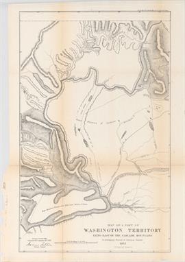
Tilton, James 1857 Map of a Part of Washington Territory Lying East of the Cascade Mountains to Accompany Report of Surveyor General This uncommon and very detailed map covers the Columbia River from Ft. Dallas eastward to Ft. Walla-Walla, and north to Ft. Colvill. The "Great Plateau of Spokane" spans the center of the map. In the upper right corner the "Gold Mines" are shown along the "Western limits of the Rock Mountains". Steven`s survey route for the Pacific Railroad, creeks, rivers, lakes, roads, the Old Presbyterian Mission are also shown. The map was surveyed by Tilton and lithographed by C.B. Graham, Washington D.C., 1857. 14" W x 22.1" H A nice, dark impression, issued folding, with minor toning and numerous fold separations backed in Japanese tissue on verso.

Morse & Gaston, 1856 Morse`s Map of Wisconsin Pocket map of the state published only eight years after statehood, showing county development in full hand color. Surveying efforts are nearly complete with only the northern counties of Douglas, La Pointe, Chippewa, Marathon and Oconto not having been surveyed. Both existing and proposed railroads are depicted along with numerous towns and villages. Published by Morse & Gaston at 115 and 117 Nassau St., New York. Folds into red embossed cloth covers with gilt title on front cover. 12.8" W x 15.8" H There are numerous separations along the folds and stains where the separations occur, along with some toning where the map was glued to the back cover. Covers are very good with minor wear.
![1898-1900 [Lot of 3] Teton Forest Reserve and Southern Part of Yellowstone Park Forest Reserve Showing Land Classification an](http://lot-images.atgmedia.com/SR/36385/2893812/253-2013117141620_468x382.jpg)
1898-1900 [Lot of 3] Teton Forest Reserve and Southern Part of Yellowstone Park Forest Reserve Showing Land Classification and Wooded Areas [and] Yellowstone National Park and Forest Reserve...[and] Yellowstone National Park and Part of Abutting Forest Reserve… "A. “Teton Forest Reserve and Southern Part of Yellowstone Park Forest Reserve Showing Land Classification and Wooded Areas”, by T.S. Brandegee, dated 1898 (14.4 x 17.5”). This map, showing Jackson Hole and Jackson Lake, was produced just one year after the establishment of the Teton Forest Reserve. A legend at bottom identifies four different land classifications. Condition: Issued folding with vivid color. (A) B. “Yellowstone National Park and Forest Reserve”, by U. S. Geological Survey, circa 1900 (19.4 x 18.5”). This finely detailed topographical map shows all of Yellowstone Park plus the region to the east up to Bighorn County, in today`s Park County. It has good topographical detail with contour intervals at 100 feet at a scale of 1 inch = 4 miles. The Upper, Shoshone, Gibbon, and Heart Lake Geyser Basins are named, along with the Mud Geysers, Mammoth Hot Springs and Old Faithful Hotel. Condition: Issued folding on a clean sheet. C. “Yellowstone National Park and Part of Abutting Forest Reserve from Maps by the U.S. Geological Survey”, by Julius Bien & Co., circa 1900 (19.8 x 18.5”). Similar map as above with the addition of cabins and ranger stations showed in black and red overprinting. Condition: Issued folding with a binding trim at left." #VALUE! See description.

Haven, John 1846 Map of the United States and Mexico Including Oregon, Texas and the Californias This rare ornamental map depicts the United States and Mexico during the Mexican-American War. It shows a small New Mexico Territory situated between the new state of Texas and the disputed area of "New California". There is a red line following the Platte, Snake and Columbia Rivers labeled the "Route of Oregon Immigrants." The map is surrounded by an ornamental border including 30 state seals with two columns of statistical information flanking the map. The last dated state is 1846 (Iowa). A similar broadside map measuring 15.3 x 10.5" is noted in Wheat (#514), containing a large text panel below the image discussing the Seat of War. 15.3" W x 14.3" H Issued folding with some light toning along the folds and some fold separations and areas of minor loss along the folds that have been repaired with archival material on verso.

Arrowsmith, John 1840 Mexico This is an attractive representation of the present-day southwestern United States, Texas and Mexico. The "Independent Republic of Texas" is bound by the Nueces River rather than the Rio Grande on its southern border. In "Upr. or New California", there is an American Fur Co. Depot on the eastern shore of "Youta or Gt. Salt L.". In New Mexico, the Great Spanish Road is shown from the Red River on the Texas boundary to Santa Fe, and then heading south through the length of Mexico. A large inset depicts central Mexico, centered on Mexico City and showing the important ports of Acapulco, Vera Cruz and Tampico. See lot 261 for this same map published just two years later with significant changes to the configuration of the "Independent Republic of Texas". 23.6" W x 19" H Original color with a couple of small spots of foxing in image, light toning along centerfold, and minor offsetting.

Lapie/Tardieu, 1841 Carte des Etats-Unis du Mexique An attractive map that shows the Southwestern United States through Mexico to the Yucatan with an inset of Central America. This map shows the "Republic of Texas" with Mexico encompassing the southwest. The Rocky Mountains are well delineated by hachure and incorporate information from Humboldt, Pike, and Long. The American Southwest reflects cartography that predates Fremont and Smith’s explorations, including two Salt Lakes and the mythical rivers that connect them to the Pacific. The large blank area to the far west is labeled "Partie Inconnue" (part unknown). 15.8" W x 21.5" H Original outline color on a bright sheet with wide margins and light toning along sheet edges.

Arrowsmith, John 1842 Mexico This edition of Arrowsmith`s southwestern United States, Texas and Mexico is dated just two years after lot 259, and now shows the "Independent Republic of Texas" in a new configuration. The Republic of Texas is shown in the stovepipe configuration, with the southern border along the Rio Grande ("R. Bravo del Norte"). The northern border now follows the 100th parallel to the Arkansas River. In "Upr. or New California", there is an American Fur Co. Depot on the eastern shore of "Youta or Gt. Salt L.". In New Mexico, the Great Spanish Road is shown from the Red River on the Texas boundary to Santa Fe, and then heading south through the length of Mexico. A large inset depicts central Mexico, centered on Mexico City and showing the important ports of Acapulco, Vera Cruz and Tampico. Although the map is dated 1842, the Texas borders reflect a date circa 1844. 23.8" W x 18.8" H Original color with light toning along the centerfold, a few spots of foxing, and a centerfold separation that enters 6" into map at bottom and has been archivally repaired on verso. The right and left margins have been trimmed, but there is still ample room for framing.

Sanson, Nicolas 1679 Audienca de Guadalajara, Nova Mexico California &c. This map was first published in 1656 and introduced the so-called second Sanson model of "California as an island". This depiction shows a small peninsula ("Agubela de Cato") above the island, two bays along the island`s northern coast and two new place names, "Tolaago" and "R. de Estiete". Sanson actually based this on information from the less well known map by Luke Foxe, but it was this map that influenced many other cartographers throughout the rest of the century. On the mainland there are new Indian tribes identified in the region of the "R. del Norte", which flows southwest from a large inland lake. This example was published in Johann David Zunners` very rare German translation of Sanson`s "L`Amerique en Plusieurs Cartes". The map was re-engraved for this edition, with only very minor differences from Sanson`s map of 1657. 9.5" W x 8" H A nice impression on watermarked paper with attractive color.
![1780-1853 [Lot of 2] Map No. 10 United States [and] L`Ancien et le Nouveau Mexique, avec la Floride et la Basse Louisiane. Pa](http://lot-images.atgmedia.com/SR/36385/2893812/264-2013117141639_468x382.jpg)
1780-1853 [Lot of 2] Map No. 10 United States [and] L`Ancien et le Nouveau Mexique, avec la Floride et la Basse Louisiane. Partie Occidentale "A. “Map No. 10. United States”, by Daniel Burgess and Co., dated 1853, hand color (9.0 x 10.4”). A very nice map of the West that displays early territorial boundaries. New Mexico Territory is shown with the post-Gadsden Purchase border and the northern extension into today`s Colorado. Oregon and Washington extend to the Continental Divide and a huge Nebraska occupies the area to the east with a small area east of Utah labeled Kansas. The large Utah Territory extends from California to the Continental Divide and locates the capital at Fillmore City, and the “Great Salt Lake City”. Each state/territory is labeled with their population: Utah 11,000, New Mexico 62,000, Oregon 13,000, and California 264,000. Numerous Indian tribes and military forts are identified. Dated 1853, but likely published in 1854-55. Condition: Nice impression and color with a few brown stains. B. “L`Ancien et le Nouveau Mexique, avec la Floride et la Basse Louisiane. Partie Occidentale”, by Rigobert Bonne, circa 1780, black and white (9.3 x 13.8”). This handsome map covers the region of present day southern California, Arizona, New Mexico, Texas and Mexico. Excellent detail, particularly of the Jesuit missions in Mexico and the Southwest, and of the numerous Indian tribes. The map locates San Diego, Santa Fe, Taos, Acapulco, Cabo St. Lucas and many towns along the Sea of Cortez and Baja Peninsula. Six distance scales at lower right. Condition: On watermarked paper with faint offsetting and a few brown spots, one of which has a tiny pinhole only visible when held to light." #VALUE! See description.

Cassell & Galpin, 1866 California and Other Western States of the United States This interesting map of the West shows some early state configurations and also names a “Gadsden Territory”. Arizona, Nevada, Idaho and Wyoming are all named, however their borders are not fully defined. In Arizona, Tuscon is also given an alternate spelling of "Tueson". "Gadsden Ter." is also called "Primeria Alta", and occupies the area south of the Gila River. There is great detail of Indian tribes, topography, towns, forts, and roads, with particularly good detail throughout California. An inset at bottom shows Washington, Oregon and Idaho. This map is based on a similar map published by Weekly Dispatch, but with numerous updates. Published by Cassell, Petter, and Galpin. 12" W x 16.8" H A faint horizontal crease and one insignificant spot.

Robert de Vaugondy, Didier 1772 Carte de la Californie Suivant I. la Carte Manuscrite de l`Amerique de Mathieu Neron Pecci... This sheet has five depictions of California that present a fascinating cartographic history of the region. It was one of ten maps compiled by Robert de Vaugondy for Diderot`s important encyclopedia and depicts the mapping of California by five important cartographers. The earliest map reproduces Neron Pecci`s manuscript map of 1604 showing the peninsula with a ragged coastline and place names derived from Cabrillo`s voyage of 1542-3. The second map is a detail from Sanson`s 1656 map showing the "island of California" with place names from the voyage of Vizcaino. Map three is from Delisle`s map of America of 1700 with the question of California`s insularity left open to interpretation. Next is Fra. Eusebio Kino`s important map of 1705 that finally ended that cartographic myth. It is based on his overland expedition from the mainland to the Sea of Cortez. Finally, map five is a portion of a Spanish map, showing the Jesuit explorations, that first appeared in Miguel Venegas` "Noticia de la California" in 1757, which is the first published history of California. This is an essential map for any California map collection. 15.3" W x 11.5" H Issued folding, now pressed flat, with faint printer`s ink residue. Trimmed close to neatline at left.
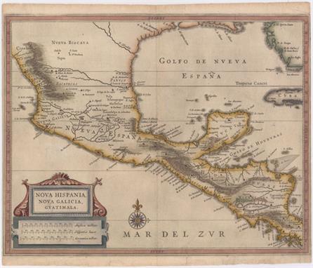
Gerritsz/De Laet, 1625 Nova Hispania, Nova Galicia, Guatimala This fine map is the work of Hessel Gerritsz, one of the most important Dutch cartographers of the 17th century. Most of his work exists only in manuscript and these maps, published by De Laet, are the only Gerritsz maps available to the collector today. The map includes Mexico through Costa Rica with considerable detail. The large strapwork cartouche incorporates the title and distance scales and the map is further decorated with a lovely compass rose. 14.2" W x 11.2" H A nice impression on watermarked paper with archival repairs to a 1/2" tear in Pacific and several short marginal tears, only one of which enters map border at bottom. Very narrow side margins, as issued.

Jansson, Jan 1638 Nova Hispania, et Nova Galicia Decorative map of the central and western coastal regions of Mexico, based on Ortelius. Mexico City is situated on a large lake below the elaborate title cartouche featuring the Royal Spanish Arms. Several gold and silver mines are located in the central region. A galleon and sea monster ornament the Pacific and armadillos walk across the scale of miles cartouche. This is a superlative example of Dutch cartography and a great example of the similarity between the work of Jansson and Blaeu. Here Jansson`s plate features a ship and sea monster with calligraphy in the Pacific, whereas Blaeu`s map lacks the calligraphy and embellished the area with two ships and a compass rose. Latin text on verso. 18.9" W x 13.7" H A dark impression on watermarked paper with old color. There is some printer`s ink residue, a couple of minor printer`s creases, and a few tiny abrasions. There are a few tears confined to blank margins, far from map.

Hondius/Bertius, 1618 Iucatana A handsome small map of the Yucatan Peninsula, Guatemala, El Salvador, Honduras, and Nicaragua. The map extends to include a portion of Cuba, and is embellished with a moire-pattern sea and a strapwork title cartouche. French text on verso. 5.2" W x 3.8" H A nice impression with attractive color and light, overall toning.

1920 Map of the Republic of Panama This large, colorful map is strongly engraved and graphically pleasing. It shows all of Panama and the "Canal Zone" as well as portions of Costa Rica and Columbia. Published by I.L. Maduro Jr. Folds into thin, stiff green pictorial wrappers with the same title. 39.8" W x 20.7" H Issued folding with light color offsetting, several ink and pencil notations in the image, and a few short splits at fold intersections. A fold separation near title appears to have been closed on recto with cello tape.

Moll, Herman 1740 A Map of the West-Indies &c. Mexico or New Spain. Also ye Trade Winds, and ye Several Tracts Made by ye Galeons and Flota from Place to Place Terrific copper engraved map covering the southern part of the United States, Mexico, Central America, the Caribbean and northern South America. Florida is shown as a stubby peninsula and the Gulf Coast cartography is still a bit confused. Locates Charlestown in the huge Carolina which includes Georgia. The map is filled with fascinating notations concerning the movements of Spain`s wealthy galleons. Their route took them into British waters off the coast of Florida and Carolina. The seas are fully engraved with the directions of trade winds added. Simple rectangular title cartouche. 10.4" W x 7.8" H A slightly uneven impression with toning along the narrow top margin, extending into the border of the map. Issued folding.

Bowen, Emanuel 1744 An Accurate Map of the West Indies. Drawn from the Best Authorities, Assisted by the Most Approved Modern Maps and Charts, and Regulated by Astronomical Observations This handsome map covers the southeastern United States, eastern Mexico, Central America, the West Indies, and the northern part of South America. It is derived from Popple`s important map of the region. The British colonies in North America are confined east of the Appalachians with France in control of Louisiana. Many early forts and Indian tribal territories are located. There are several interesting notations concerning the history of the region, such as a notation concerning the southern boundary of the "Province of Carolina", "so that Fort St. Augustin as well as Georgia falls within these limits." Trade winds and sea routes are marked throughout, including the course of the Spanish gold fleet from "Old Spain" and the return trip from Cartagena and Vera Cruz. The title cartouche is adorned with Native Americans and an incongruous lion (likely representing the British colonies). 16.6" W x 13.7" H Issued folding, now pressed, with good margins and a hint of soiling along folds.

Rossi, Veremondo 1763 Nuova e Corretta Carta dell` Indie Occidentali Cavata Dalle Migliori Autorita This attractive and uncommon Italian map of the West Indies covers the region from the Carolinas south to the Oronoco River in South America. There is good detail of the islands and coastlines, with the southern tip of Florida being depicted as a series of islands. A key in the Pacific Ocean identifies which islands in the Caribbean are owned by the English, French, Dutch, Spanish, Danish and which are "neutral" islands. 13.8" W x 10.8" H There is a centerfold separation at top that enters 0.5" into the image closed on verso with archival tape and some faint scattered foxing in the image.

Rizzi-Zannoni, Giovanni Antonio 1780 Carte Geo-Hydrographique du Golfe du Mexique et de Ses Isles... Finely engraved map covering the U.S. and Mexican coastlines, Central America, northern South America, and all of the major islands of the West Indies, also naming some very small ones. The map is filled with great coastal detail and many place names. Southern Florida here is broken into an archipelago. This lovely chart is adorned with a garland style title cartouche, a fleur-de-lys, and rhumb lines. 17.6" W x 12.3" H Light stains and faint spots in the image with a few damp stains and minute wormholes confined to the blank margins.

Kitchin, Thomas 1783 Map of the European Settlements in Mexico or New Spain and the West Indies This detailed and expansive map covers all of the southern United States north to the Carolinas and Cape Henry. The map continues west through the region labeled "Great Space of Land unknown" to the southern tip of Baja California. All of the Caribbean is shown, naming the "Great Antilles", Cuba, and the Bahamas, with the Windward and Leeward together identified as the "Caribbe Is". It is filled with place names, rivers and Indian tribes. Decorated with a delicate title cartouche. 20" W x 12.3" H Issued folding and now flattened with offsetting. Remargined at left with old paper to better accommodate framing.

Sanson, Nicolas 1683 Les Isles Antilles Entre Lesquelles sont les Lucayes et les Caribes Attractive map covering the southern tip of Florida and all of the Caribbean islands. There is good detail, especially on Cuba and Hispaniola, which display numerous place names and mountains in profile. Engraved by Antoine de Winter. 12.1" W x 8.3" H A fine impression and attractive color with light, overall toning.

![Raspe, Gabriel Nikolaus 1764 Plan der Insul Cuba... [on sheet with] Plan der Stadt u Hafens Havana [and] Prospect der Stadt H](http://lot-images.atgmedia.com/SR/36385/2893812/289-2013117141722_468x382.jpg)
Raspe, Gabriel Nikolaus 1764 Plan der Insul Cuba... [on sheet with] Plan der Stadt u Hafens Havana [and] Prospect der Stadt Havana… This interesting sheet highlights Cuba and the important port city of Havana shortly after the end of the Seven Years` War. Historically under Spanish rule, Havana was overtaken by the British in 1762, but was surrendered less than a year later in the Peace of Paris, in which the British received Florida in exchange for Cuba. This sheet contains a map of Cuba and both a plan and view of Havana, which had become the third largest city in the Americas. The detailed bird`s-eye plan of Havana includes a numbered key identifying 9 locations. Maps by Raspe are uncommon and rarely found on the market. 14.3" W x 8.6" H Original color on watermarked paper with light printer`s ink residue and marginal soiling.

Thomson, John 1816 Island of Cuba This attractive map of Cuba also shows the Great Bahama Bank and the Bahama Channel. Depicts Havana, principal harbors, points, shoals, and topography through hachure. Decorated by a simple compass rose and distance scale in British miles. 23" W x 9" H There is some soiling, offsetting and a short centerfold separation at bottom. Remargined at top with neatline skillfully replaced in facsimile.

Vandermaelen, Philippe Marie Guillaume 1825 Ile de Cuba This fine, large-scale map covers central Cuba from just west of Havana to east of Bayama and includes the Caymans and most of Jamaica. It provides minute detail of the topography, towns and villages, roads and coastal features. The inset text block describes the island`s climate, soil, topography, produce, economy, government and religion. This map is from the "Atlas Universel", the first atlas to present all the maps on the same scale (1: 1,641,836), with each map covering an area of approximately 20 degrees of longitude (from Paris) and 6 degrees of latitude. The atlas was also the first lithographic atlas ever published. There was only one edition, published in 1825-27, and the subscription list shows that 810 copies were sold. 21.3" W x 18.2" H A good impression with original outline color and wide, original margins. There are a couple of faint spots in the text but the map is overall near fine.
![Crepy, (Family) 1767 La Jamaique aux Anglois dans le Golfe du Mexique [on sheet with] La Bermude aux Anglois This is a reissu](http://lot-images.atgmedia.com/SR/36385/2893812/293-2013117141730_468x382.jpg)
Crepy, (Family) 1767 La Jamaique aux Anglois dans le Golfe du Mexique [on sheet with] La Bermude aux Anglois This is a reissued map that was originally published by George Le Rouge in 1746. The sheet contains two maps, Jamaica above Bermuda. Jamaica is engraved to show the plantations, denoting those growing sugar, cotton, cacao, and indigo. The map of Bermuda includes an interesting cartographic error resulting from the copying John Speed`s map of 1627. In that map, Bermuda was superimposed over a map of the coastline of New England and Virginia to show the relative position of Bermuda. Here, the coastlines of North America are gone, but the small depiction of an additional Bermuda remains, which appears on this map as a small offshore island named "Bermudos." 10.7" W x 7.9" H On watermarked paper with faint toning along the centerfold and scattered light foxing, mostly confined to the blank margins. There is a piece of masking tape running across the top blank margin on verso.

Wytfliet, Cornelis 1597 Hispaniola Insula This is one of only two Caribbean maps in this important work, which was the first atlas dedicated to the New World. It provides an important, early view of Hispaniola with a small part of eastern Cuba. The map provides a fairly accurate depiction of the island with the locations of early colonial settlements and Indian villages. "P. Nativitat" on the north coast of present-day Haiti is where Columbus built his first settlement in 1492. The handsome map is embellished with a large strapwork title cartouche and a fully engraved moiré-patterned sea. 11.4" W x 9" H There are several small abrasions along the centerfold, faint offsetting, and a small centerfold separation at bottom confined to the blank margin.

Kuffner, Paul 1777 Caraibische Inseln This scarce map was published in the second part of Oldendorp`s "Geschichte der Mission der Evangelischen Brueder auf den Caraibischen Inseln St. Thomas, St. Croix, St. Jan…" or a "History of the Evangelical Brethren on the Caribbean Islands of St. Thomas, St. Croix and St. John". The book is considered the first published work detailing the history, resources and social conditions in the Danish West Indies, today`s Virgin Islands. The map details the islands from most of Hispaniola through Puerto Rico, the Virgin Islands and down the Windward and Leeward Islands to include Trinidad and Tobago. The map is embellished with a compass rose and scroll-style title cartouche. Engraved by Kuffner in Nuremberg. 13.8" W x 12.1" H Issued folding, now pressed, on watermarked paper with one tiny hole at a fold intersection that has been professionally repaired. An excellent impression with a few small spots in image and a professionally repaired chip at bottom left that does not affect image.
-
109198 item(s)/page