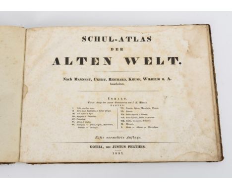

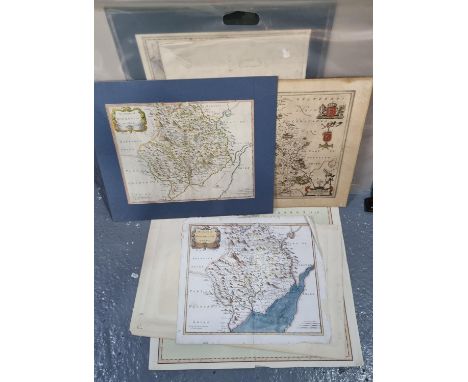
Kartenwerk: "Schul-Atlas der Alten Welt"14 kolorierte Kupferstiche. 22,5 x 30,5 cm. Vollständiges, gebundenes Buch mit 14 historischen, grenzkolorierten Landkarten, betitelt "Schul-Atlas der Alten Welt. Nach Mannert, Ukert, Reichard, Kruse, Wilhelm u. A. bearbeitet.", mit 10-seitigem Begleittext "Kurzer Abriss der Alten Geographie von J.H. Möller", 11. Auflage, Gotha, bei Justus Perthes, 1837. Stockfleckig, Einband mit Alters-/Gebrauchsspuren. Map Work: "School Atlas of the Ancient World"14 colored copperplate engravings. 22.5 x 30.5 cm. Complete hardcover book with 14 historical border colored maps, titled "Schul-Atlas der Alten Welt. Nach Mannert, Ukert, Reichard, Kruse, Wilhelm u. A. bearbeitet.", with 10-page accompanying text "Kurzer Abriss der Alten Geographie von J.H. Möller", 11th edition, Gotha, by Justus Perthes, 1837. Stick stained, cover with age/use marks. *This is an automatically generated translation from German by deepl.com and only to be seen as an aid - not a legally binding declaration of lot properties. Please note that we can only guarantee for the correctness of description and condition as provided by the German description.
We found 109198 price guide item(s) matching your search
There are 109198 lots that match your search criteria. Subscribe now to get instant access to the full price guide service.
Click here to subscribe- List
- Grid
-
109198 item(s)/page

SANTINI, Paolo(Wohl 1729 - 1793) Landkarte von DalmatienKupferstich. 1789. Blatt: 50,5 x 64 cm, im Passepartout: 63,5 x 79 cm. Landkarte des westlichen Teils der historischen Region Dalmatien, herausgegeben von Franz Anton Schraembl; verso in Tinte "Dalmatien". Stärker griffspurig, etwas knickspurig. Franz Anton Schraembl (1751 Wien - 1803 Wien): österreichischer Schriftsteller, Kartograf, Buchhändler und Verleger. SANTINI, Paolo(Probably 1729 - 1793) Map of DalmatiaCopper engraving. 1789. Sheet: 50.5 x 64 cm, in passepartout: 63.5 x 79 cm. Map of the western part of the historical region of Dalmatia, published by Franz Anton Schraembl; verso in ink "Dalmatia". Stronger grip, some creasing. Franz Anton Schraembl (1751 Vienna - 1803 Vienna): Austrian writer, cartographer, bookseller and publisher. *This is an automatically generated translation from German by deepl.com and only to be seen as an aid - not a legally binding declaration of lot properties. Please note that we can only guarantee for the correctness of description and condition as provided by the German description.

HOMANN, Johann Baptist(1664 Oberkammlach - 1724 Nürnberg) Landkarte des Russischen ReichesKolorierter Kupferstich. Platte: 49 x 57 cm. Gerahmt & hinter Glas : 62,5 x 71 cm. Historische Karte des Zarenreiches Russland, mit figürlicher Titelkartusche "Generalis Totius Imperii Russorum [...]", dekoriert mit Schiffsstaffage und Meeresungeheuer. Bugfalte, stockfleckig, Randbereich stärker knickspurig. Deutscher Kartograf, Kupferstecher, Verleger und Globenhersteller; bedeutendster deutscher Herausgeber von Atlanten und Landkarten im 18. Jh. HOMANN, Johann Baptist(1664 Oberkammlach - 1724 Nuremberg) Map of the Russian EmpireColored copperplate engraving. Plate: 49 x 57 cm. Framed & behind glass : 62.5 x 71 cm. Historical map of the Tsarist Empire of Russia, with figural title cartouche "Generalis Totius Imperii Russorum [...]", decorated with ship staffage and sea monsters. Buckling, foxing, marginal area more creased. German cartographer, engraver, publisher and globe maker; most important German publisher of atlases and maps in the 18th century .*This is an automatically generated translation from German by deepl.com and only to be seen as an aid - not a legally binding declaration of lot properties. Please note that we can only guarantee for the correctness of description and condition as provided by the German description.
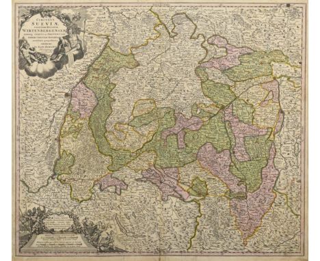
HOMANN, Johann Baptist(1664 Oberkammlach - 1724 Nürnberg) Landkarte des Herzogtums Württemberg und des Schwäbischen KreisesKolorierter Kupferstich. Um 1720. Platte: 49,5 x 57 cm. Gerahmt & hinter Glas : 67 x 73,5 cm. Detailreiche historische Karte des Herzogtums Württemberg und des Schwäbischen Kreises, figürliche Titelkartusche "Circulus Sueviae Continens Ducatum Wirtenbergensem [...]" und weiterer figürlicher Kartusche mit Legende und Meilenzeiger. Stockfleckig, Bugfalte, griff- und knickspurig. Deutscher Kartograf, Kupferstecher, Verleger und Globenhersteller; bedeutendster deutscher Herausgeber von Atlanten und Landkarten im 18. Jh. HOMANN, Johann Baptist(1664 Oberkammlach - 1724 Nuremberg) Map of the Duchy of Württemberg and the Swabian DistrictColored copperplate engraving. Circa 1720. Plate: 49.5 x 57 cm. Framed & behind glass : 67 x 73.5 cm. Detailed historical map of the Duchy of Württemberg and the Swabian County, figural title cartouche "Circulus Sueviae Continens Ducatum Wirtenbergensem [...]" and another figural cartouche with legend and mileage indicator. Stick stained, centerfold, grip and crease. German cartographer, engraver, publisher and globe maker; most important German publisher of atlases and maps in the 18th century .*This is an automatically generated translation from German by deepl.com and only to be seen as an aid - not a legally binding declaration of lot properties. Please note that we can only guarantee for the correctness of description and condition as provided by the German description.

HOMANN, Johann Baptist (Erben) Landkarte der Österreichischen NiederlandeKupferstich. 1747. Blatt: 50 x 59 cm. Historische Landkarte von Belgien und Luxemburg, Titelkartusche mit Wappen der 10 zugehörigen Provinzen "Brabant, Limburg, Luxemburg, Geldern, Flandern, Artois, Hennegau, Namur, Mecheln und Antwerpen", bezeichnet "Belgivm Catholicvm feu Decem Provinciae Germaniae Inferioris [...]", nach einer Karte von Tobias Mayer (1723 Marbach - 1762 Göttingen). Hinterklebte Bugfalte, griffspurig, etwas stockfleckig und fleckig. Johann Baptist Homann (1664 - 1724), deutscher Kartograf, Kupferstecher, Verleger und Globenhersteller; bedeutendster deutscher Herausgeber von Atlanten und Landkarten im 18. Jh. HOMANN, Johann Baptist (Heirs) Map of the Austrian NetherlandsCopper engraving. 1747. Sheet: 50 x 59 cm. Historical map of Belgium and Luxembourg, title cartouche with arms of the 10 associated provinces "Brabant, Limburg, Luxembourg, Guelders, Flanders, Artois, Hainaut, Namur, Mechelen and Antwerp", inscribed "Belgivm Catholicvm feu Decem Provinciae Germaniae Inferioris [....]", after a map by Tobias Mayer (1723 Marbach - 1762 Göttingen). Backglued centerfold, grip-marked, some foxing and staining. Johann Baptist Homann (1664 - 1724), German cartographer, engraver, publisher and globe maker; most important German publisher of atlases and maps in the 18th century .*This is an automatically generated translation from German by deepl.com and only to be seen as an aid - not a legally binding declaration of lot properties. Please note that we can only guarantee for the correctness of description and condition as provided by the German description.

HUEBER, Joseph Benedikt "Topographische Beschreibung der Landschaft Lungau im Fürstenthum Salzburg" und andere LandschaftsbeschreibungenIn der hochfürstlichen ... Waisenhausbuchhandlung. Salzburg. 1786. 19,5 x 12 cm. Tafel "Aussicht über ein Teil von Lungau ...", Titel, (8), 66 Seiten und 2 Tafeln mit Statistiken. / "Topographische Beschreibung der Landschaft des Oberpinzgaus im Erzstift Salzburg", Karte "Krimml und der berühmt Wasserfall", Titel, 116, (12) Seiten. "Historisch-topographisch- und ökonomische Beschreibung des Salzburgischen Pfleggerichts Lichtenberg oder Salfelden", Salzburg 1802. (6), 54 Seiten. / "Das Innviertel mit dem Hausruckviertel", Salzburg 1810. 36 Seiten. Im Halbledereinband. Ecken und Kanten etwas berieben, eine Ecke etwas stärker, Vorsatz beschrieben. Provenienz : Besitzstempel: ""2. Inf. Reg. Kronprinz". HUEBER, Joseph Benedikt "Topographical Description of the Landscape Lungau in the Principality of Salzburg" and Other Landscape DescriptionsIn der hochfürstlichen ... Orphanage Bookstore. Salzburg. 1786. 19.5 x 12 cm. Plate "View over a part of Lungau ...", title, (8), 66 pages and 2 plates with statistics. / "Topographical description of the landscape of the Upper Pinzgau in the Archbishopric of Salzburg", map "Krimml and the famous waterfall", title, 116, (12) pages. "Historisch-topographisch- und ökonomische Beschreibung des Salzburgischen Pfleggerichts Lichtenberg oder Salfelden", Salzburg 1802. (6), 54 pp. / "The Innviertel with the Hausruckviertel", Salzburg 1810. 36 pages. In half leather binding. Corners and edges a little rubbed, one corner a little stronger, endpapers written. Provenance : ownership stamp: ""2nd Inf. Reg. Crown Prince". *This is an automatically generated translation from German by deepl.com and only to be seen as an aid - not a legally binding declaration of lot properties. Please note that we can only guarantee for the correctness of description and condition as provided by the German description.

VALCK, Gerard (und Leonard)(1651 - 1726) Landkarte von OberitalienKolorierter Kupferstich. Blatt: 52 x 61 cm, auf Karton montiert: 54 x 64 cm. Historische Landkarte von Oberitalien, mit Titelkartusche "Status Mediolanensis, nec non ducatum Mantua, Modenae, Parmae ut et Genuensis Reipublicae [...]". Bugfalte, griffspurig. Familie von niederländischen Kupferstechern, Globenherstellern und Verlegern. VALCK, Gerard (and Leonard)(1651 - 1726) Map of Upper ItalyColored copperplate engraving. Sheet: 52 x 61 cm, mounted on cardboard: 54 x 64 cm. Historical map of Upper Italy, with title cartouche "Status Mediolanensis, nec non ducatum Mantua, Modenae, Parmae ut et Genuensis Reipublicae [...]". Buckling, traces of handling. Family of Dutch engravers, globe makers and publishers. *This is an automatically generated translation from German by deepl.com and only to be seen as an aid - not a legally binding declaration of lot properties. Please note that we can only guarantee for the correctness of description and condition as provided by the German description.
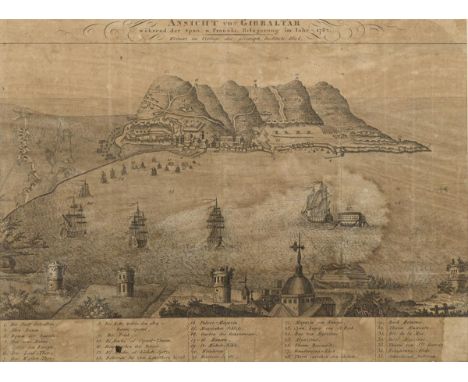
Blick auf GibraltarKupferstich. Passepartoutausschnitt: 22,5 x 30,5 cm. Gerahmt & hinter Glas : 31,5 x 40 cm. Historische Militärkarte: "Ansicht von Gibraltar während der Span. u. Französ. Belagerung im Jahr 1782. Weimar im Verlage des geograph. Instituts. 1806", mit Legende. Blatt mit starkem Lichtschaden, Bugfalten, Wasserschaden. View of GibraltarCopper engraving. Passepartout cut-out: 22.5 x 30.5 cm. Framed & behind glass : 31.5 x 40 cm. Historical military map: "View of Gibraltar during the Span. u. French. siege in 1782. Weimar in the publishing house of the geograph. Institut. 1806", with legend. Sheet with strong light damage, bow folds, water damage. *This is an automatically generated translation from German by deepl.com and only to be seen as an aid - not a legally binding declaration of lot properties. Please note that we can only guarantee for the correctness of description and condition as provided by the German description.

SCHENK, Pieter d. J.(1693 Amsterdam - 1775 Amsterdam) Landkarte der Grafschaft MansfeldKolorierter Kupferstich. Blatt: 56,8 x 66 cm. Historische Karte der Grafschaft Mansfeld, mit figürlicher Titelkartusche "Accurate Geographische Delineation der Graffschaft Mannsfelt Sowohl Chursächsisch : als Brandenbur. Hoheit [...]" und ausführlicher Legende. Doubliert, stockfleckig, knick- und griffspurig, Randbereich rissig. Sohn des Kupferstechers und Kartenverlegers Pieter Schenk d. Ä. (1660 - 1711), gilt als bedeutendster Verleger sächsischer Spezialkarten im 18. Jh. SCHENK, Pieter the Younger(1693 Amsterdam - 1775 Amsterdam) Map of the County of MansfeldColor copperplate engraving. Sheet: 56.8 x 66 cm. Historical map of the county of Mansfeld, with figural title cartouche "Accurate Geographical Delineation of the County of Mannsfelt Both Chursächsisch : als Brandenbur. Hoheit [...]" and detailed legend. Doubled, foxing, crease and grip, marginal cracking. Son of the engraver and map publisher Pieter Schenk the Elder (1660 - 1711), is considered the most important publisher of Saxon special maps in the 18th century .*This is an automatically generated translation from German by deepl.com and only to be seen as an aid - not a legally binding declaration of lot properties. Please note that we can only guarantee for the correctness of description and condition as provided by the German description.

HOMANN, Johann Baptist (Erben) Landkarte von SachsenKolorierter Kupferstich. 1734. Blatt: 50,5 x 59 cm. Historische Karte des Obersächsischen Reichkreises, mit detailreicher Titelkartusche "Circuli Supe. Saxoniae pars meridionalis sive ducatus. electoratus [...]" und Legende; nach einer Karte von Johann Wilhelm Zollmann (1697 Coburg - 1749 Dresden) und Adam Friedrich Zürner (1679 Marieney - 1742 Dresden). Doubliert, griffspurig. Johann Baptist Homann (1664 - 1724), deutscher Kartograf, Kupferstecher, Verleger und Globenhersteller; bedeutendster deutscher Herausgeber von Atlanten und Landkarten im 18. Jh. HOMANN, Johann Baptist (Heirs) Map of SaxonyColored copperplate engraving. 1734. Sheet: 50.5 x 59 cm. Historical map of the Upper Saxon Imperial District, with detailed title cartouche "Circuli Supe. Saxoniae pars meridionalis sive ducatus. electoratus [...]" and legend; after a map by Johann Wilhelm Zollmann (1697 Coburg - 1749 Dresden) and Adam Friedrich Zürner (1679 Marieney - 1742 Dresden). Doubled, traces of handling. Johann Baptist Homann (1664 - 1724), German cartographer, engraver, publisher and globe maker; most important German publisher of atlases and maps in the 18th century .*This is an automatically generated translation from German by deepl.com and only to be seen as an aid - not a legally binding declaration of lot properties. Please note that we can only guarantee for the correctness of description and condition as provided by the German description.

Genealogische Karte der ersten Könige von Neapel, Sizilien und Ungarn Kupferstich. Blatt: 45,7 x 103 cm. Stammbaum der ersten, aus dem französischen Königshaus und Königshaus von Navarra entstammenden Könige von Neapel, Sizilien und Ungarn, bezeichnet "Carte Genealogique des premiers Rois de Naples, de Sicile et de Hongrie, issus de la famille Roialle de France, ainsi que les rois de Navarre [...]"; aus "Atlas Historique" nach den Tafeln von Henri Abraham Chatelain. Bugfalten, griffspurig, etwas fleckig. Genealogical map of the first kings of Naples, Sicily and Hungary Copper engraving. Sheet: 45.7 x 103 cm. Family tree of the first kings of Naples, Sicily and Hungary, descended from the French royal house and royal house of Navarre, inscribed "Carte Genealogique des premiers Rois de Naples, de Sicile et de Hongrie, issus de la famille Roialle de France, ainsi que les rois de Navarre [....]"; from "Atlas Historique" after the plates of Henri Abraham Chatelain. Bow creases, traces of handling, some staining. *This is an automatically generated translation from German by deepl.com and only to be seen as an aid - not a legally binding declaration of lot properties. Please note that we can only guarantee for the correctness of description and condition as provided by the German description.

HOMANN, Johann Baptist(1664 Oberkammlach - 1724 Nürnberg) Landkarte von Sachsen und ThüringenKolorierter Kupferstich. Blatt: 51,5 x 59,5 cm, im Passepartout: 64 x 73 cm. Historische Karte des Obersächsischen Reichskreises, mit detailreicher Titelkartusche "Circulus Saxoniae Superioris in quo Ducatus & Electoratus Saxoniae Marchionatus Misniae et Landgraviatus Thuringiae [...]". Hinterklebte Bugfalte, fleckig. Deutscher Kartograf, Kupferstecher, Verleger und Globenhersteller; bedeutendster deutscher Herausgeber von Atlanten und Landkarten im 18. Jh. HOMANN, Johann Baptist(1664 Oberkammlach - 1724 Nuremberg) Map of Saxony and ThuringiaColored copperplate engraving. Sheet: 51.5 x 59.5 cm, in passepartout: 64 x 73 cm. Historical map of the Upper Saxon Imperial District, with detailed title cartouche "Circulus Saxoniae Superioris in quo Ducatus & Electoratus Saxoniae Marchionatus Misniae et Landgraviatus Thuringiae [...]". Backglued centerfold, stained. German cartographer, engraver, publisher and globe maker; most important German publisher of atlases and maps in the 18th century .*This is an automatically generated translation from German by deepl.com and only to be seen as an aid - not a legally binding declaration of lot properties. Please note that we can only guarantee for the correctness of description and condition as provided by the German description.

HOMANN, Johann Baptist (Erben) Landkarte der Region LausitzKolorierter Kupferstich. Platte: 50 x 58 cm. Gerahmt & hinter Glas : 58 x 65 cm. Detailreiche historische Landkarte der Nieder- und Oberlausitz und Umgebung, figürliche Titelkartusche "Totius Marchionatus Lusatiae tam superioris quam inferioris [...]" und Beikartusche mit dekorativer Ernteszene und Wappendarstellung. Blatt etwas gebräunt, etwas stockfleckig, Bugfalte. Johann Baptist Homann (1664 - 1724), deutscher Kartograf, Kupferstecher, Verleger und Globenhersteller; bedeutendster deutscher Herausgeber von Atlanten und Landkarten im 18. Jh. HOMANN, Johann Baptist (Heirs) Map of the Lusatia regionColored copperplate engraving. Plate: 50 x 58 cm. Framed & behind glass : 58 x 65 cm. Detailed historical map of Lower and Upper Lusatia and surroundings, figural title cartouche "Totius Marchionatus Lusatiae tam superioris quam inferioris [...]" and subsidiary cartouche with decorative harvest scene and coat of arms representation. Sheet somewhat browned, some foxing, centerfold. Johann Baptist Homann (1664 - 1724), German cartographer, engraver, publisher and globe maker; most important German publisher of atlases and maps in the 18th century .*This is an automatically generated translation from German by deepl.com and only to be seen as an aid - not a legally binding declaration of lot properties. Please note that we can only guarantee for the correctness of description and condition as provided by the German description.
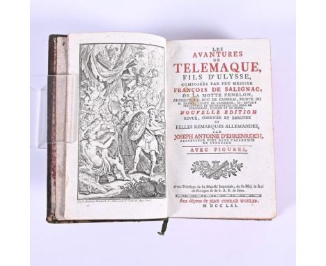
SALIGNAC / FENELON, "Les Avantures de Telemaque, fils d`Ullysse"Deutsch von Joseph Antoine d'Ehrenreich. Aux dépens de Jean Conrad Wohler. Königreich Sachsen. 1761. 17 x 10 cm. In französischer Sprache mit ausführlichen deutschen Erläuterungen zur Übersetzung, auf jeder Seite. Titelbild, Titel, Bildnis, (8), 344, 294 (46) Seiten, eine Landkarte und 24 ganzseitige Kupferstiche. Lederausgabe mit Goldprägung, Rotschnitt. Leichte Altersspuren. Exlibris mit Wappen. SALIGNAC / FENELON, "Les Avantures de Telemaque, fils d`Ullysse"German by Joseph Antoine d'Ehrenreich. Aux dépens de Jean Conrad Wohler. Kingdom of Saxony. 1761. 17 x 10 cm. In French with detailed German explanations of the translation, on each page. Frontispiece, title, portrait, (8), 344, 294 (46) pages, a map and 24 full-page copper engravings. Leather edition with gilt, red edges. Light signs of age. Exlibris with coat of arms. *This is an automatically generated translation from German by deepl.com and only to be seen as an aid - not a legally binding declaration of lot properties. Please note that we can only guarantee for the correctness of description and condition as provided by the German description.

VALCK, Gerard (und Leonard)(1651 - 1726) Landkarte der Region PicardieKolorierter Kupferstich. Blatt: 50,7 x 61 cm, auf Karton montiert: 54 x 64 cm. Historische Landkarte der Region Picardie in Nord-Frankreich, Titelkartusche "Praefectura Piccardiae, eaque partita in Comitatus Guinensem [...]". Griff- und knickspurig, fleckig. Familie von niederländischen Kupferstechern, Globenherstellern und Verlegern. VALCK, Gerard (and Leonard)(1651 - 1726) Map of the Picardy regionColored copperplate engraving. Sheet: 50.7 x 61 cm, mounted on cardboard: 54 x 64 cm. Historical map of the Picardy region in northern France, title cartouche "Praefectura Piccardiae, eaque partita in Comitatus Guinensem [...]". Grip and crease marks, stained. Family of Dutch engravers, globe makers and publishers. *This is an automatically generated translation from German by deepl.com and only to be seen as an aid - not a legally binding declaration of lot properties. Please note that we can only guarantee for the correctness of description and condition as provided by the German description.


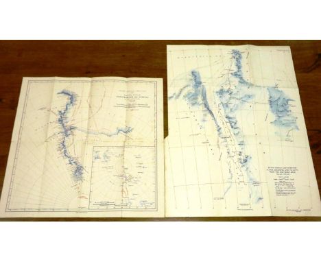
British Antarctic Expedition 1907 General Map showing the Explorations and Surveys of the Expedition 1907-1909, pub. William Heinemann. Foxed and light wear down fold lines. Together with Sledge Journeys and Flights from the Southern Base Aug 1936-Feb 1937, British Graham Land Expedition. (2) P&P Group 1 (£14+VAT for the first lot and £1+VAT for subsequent lots)


Collection of single Speyside malt miniature whisky bottlings, Gordon & MacPhail, Connoisseurs Choice, new map label, 1990/2000s bottling: Benrinnes 1972 and 1973, Caperdonich 1968, Coleburn 1972, Dallas Dhu 1971,Glenlossie 1974, 1975, 1978 (46%),Auchroisk 1993 (43%)Aultmore 1995 (43%, no carton)Balmenach 1989, (43%)Dailuaine 1991, (43%)Dufftown 1993, (43%)Glen Keith 1993 x2, (46%, one without carton)Glen Spey 1995, (43%)Glendullan 1993, (43%, no carton)Inchgower 1993, (43%, no carton)Mannochmore 1984, 1990 (46%)Pittyvaich 1993, (43%),Tormore 1996, (43%), each 5cl, 40% and in carton unless otherwise stated.Qty: 22


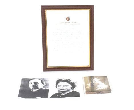
A silver cigarette case, LS, import marks for London 1936, engine-turned with applied map of the United Kingdom and Republic of Ireland to front, engraved initials to interior, with a handwritten letter from Bridget D'Oyly Carte stating that it had belonged to her father, Rupert D'Oyly Carte, on Savoy Hotel headed paper, framed.Qty: 2Condition report:The case weighs 5oz. There is a small dent on the corner, otherwise no cracks or dings.


A SMALL QUANTITY OF PAINTINGS AND PRINTS, to include oils on board signed A.S. Antliff scenes include a landscape, coastal landscape and a view to an industrial backdrop, largest size approximately 60cm x 90cm, Robert Cox still life flower study, oil on canvas, watercolour of Lake Bala by Winifred Burlingham, David Cartwright signed limited edition print 'A Time for Heroes', large Charles Giraud print, approximate size 91cm x 117cm including frame, a Robert Morden map of Staffordshire with hand tinting, together with assorted other paintings and prints
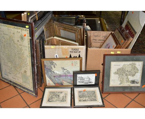
TWO BOXES AND LOOSE PICTURES AND PRINTS, to include a distressed late Victorian or Early Edwardian portrait of a gentleman, in need of restoration, approximate size 60cm x 49cm, a watercolour depicting a river landscape, signed and dated T.B Ellerby 1914 - frame distressed, Boris o'Klein humorous dog print signed in pencil to lower margin, map of Cheshire by J & C Walker, together with assorted framed prints some in distressed condition


Siegfried Atlas. Switzerland. Mountaineering Interest. Cased set of nine maps, Bern: Landestopographie, 1910-1923. Sectional & linen-backed with the exception of Grindelwald, which is a smaller map on paper. Bearing mapseller's paper label & stamp: Sifton, Praed & Co. Ltd., 67 St. James's Street, London. Comprising: Grindelwald; Visperthal; Berninapass; Splugenpass; Scheidegg; Sustenpass; Interlaken-Gsteig; Albula; Grimsel. All of the maps are very well-preserved, clean, bright; the linen has very pale discolouration, and a few of the paper labels have slight wear. Housed in a lockable leather carrying case with some wear from use

Late-Victorian/Edwardian map block puzzle, comprising 20 wooden cubes with pasted maps on all sides, forming alternative jigsaws, London: G. W. Bacon, n.d., in card case bearing England & Wales map to lid, and five loose Bacon maps within. The cubes are generally well-preserved, some cockling to paper in places, slight wear & pale spotting in places, case worn

North, Stanley Kennedy. British Empire Exhibition 1924, London, folding guide featuring colour lithographic map, together with four publications relating to WW1, including Bruce Bairnsfather: A Few Fragments from His Life, London: Hodder & Stoughton for The Bystander [1916], all with wear & loss, collection sold as found with all faults (5)
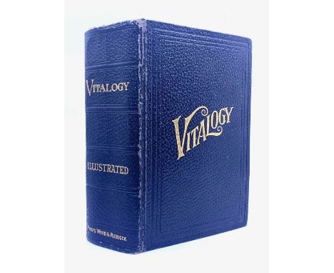
Miscellaneous collection of books to include Vitalogy: An Encyclopedia of Health and Home, by E. H. Ruddock, 1930; Aristotle's Masterpiece, London: Clifton Chambers, n.d. [c.1900]; Rupert Magic Painting Annual, Daily Express, 1960; Map & Guide of London, Francis Chichester, c.1950s, and others, condition varied, sold as found with all faults, together with a circa 1960s BOAC Speedbird advertising fan of card & bamboo construction, well-preserved (9)

KAMINUHR MIT NAPOLEON, Frankreich 1. viertel 19. Jh., Bronze feuervergoldet, Sockel sowie Gehäuseoberteil mit aufgelegten Zierapplikationen, obenauf stehend Napoleon mit Schwert, neben Symbolen seiner Feldzüge Siegeskranz, Landkarte und Heerbanner, Ziffernblatt im unteren Teil bezeichnet: „Maistre a Paris Werk mit Fadenaufhängung und schlag auf Glocke zur halben und vollen Stunde, Rückseitig bezeichnet „HTH AZUR“. HxBxT: 30,5/24,5/9,5 cm Leichte Alters und Gebrauchsspuren, Werk läuft kurz an.| MANTEL CLOCK WITH NAPOLEON, France 1st quarter of the 19th century, fire-gilt bronze, base and upper part of the case with applied decorative applications, standing on top Napoleon with sword, next to symbols of his campaigns victory wreath, map and army banner, dial in the lower part inscribed: "Maistre a Paris movement with thread suspension and strike on bell at half and full hour, inscribed "HTH AZUR" on the back. HxWxD: 30.5/24.5/9.5 cm Slight signs of age and wear, movement starts to run briefly.


-
109198 item(s)/page