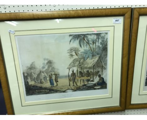

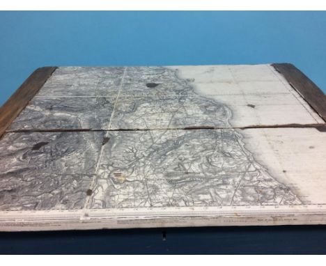
AFTER CHARLES BENTLEY "Ataraipu or The Devil's Rock", "Roraima", "Junction of the Kundanama with the Paramu Watu Ticaba" and "Brazilian Fort St. Gabriel", colour lithographs by George Barnard and others, printed by C Hullmandel, published Ackermann & Co., 1840, 32.5 cm x 42 cm, another four to match the above "Esmerelda on the Orinoco", "Brazilian Fort St. Gabriel", "Ataraipu or The Devil's Rock", "Junction of the Kundanama with the Paramu", 33 cm x 42 cm, AFTER CHARLES BENTLEY "Watu Ticava", lithograph by George Barnard as before, together with "Roraima", "Christmas Cataract" and "Pure-Piapia", a set of four, 33 cm x 42 cm and a folio containing "Twelve views in the Interior of Guian; ...... from drawings executed by Mr Charles Bentley.....", published London Ackermann & Co. 96 Strand CONDITION REPORTS There are 13 framed prints in total - some show signs of foxing and some slight discolouration. Thunder bugs, etc underneath the glass and glass needs cleaning. One copy of "Roraima" has a large area of foxing to the top right hand corner and one copy of "Ataraipu or The Devil's Rock" has a tear in the bottom left. See images for more detail. Folio - all leaves are loose - no plates present. Frontispiece there. Some areas of foxing throughout particularly to one page - see image for details, as well as damage to the edges.Also - map has a bad rip to the middle and to the right hand edge as well. Areas of foxing throughout, etc. See images for more details.
We found 109182 price guide item(s) matching your search
There are 109182 lots that match your search criteria. Subscribe now to get instant access to the full price guide service.
Click here to subscribe- List
- Grid
-
109182 item(s)/page


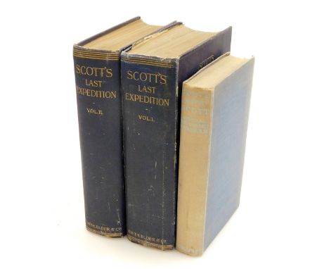
Scott (R.F., Captain). Scott's Last Expedition, volumes 1 and 2, first edition, with black and white illustrations and folding maps, blue cloth bound with gilt tooling, published by Smith Elder and Co, London, 1913, and Evans (Edward R.G.R., Admiral) South With Scott, with black and white illustrations and loose folding map, blue cloth bound, published by Collins, London and Glasgow. (3)

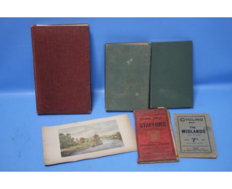
Paterson (Daniel). A New and Accurate Description of all the Direct and Principal Crossroads in England and Wales, 8th edition, half of map remaining on frontispage, with marbled paper boards, printed for F.Power, nephew and successor to the late Mr T Carnan, no. 65, in St Paul's Church Yard, 1789, (AF), and Defoe (Daniel) A Tour Through The Whole Island of Great Britain Divided Into Circuits or Journeys, volume 4 of 4 volumes, 7th edition, undated, with speckled leather boards and gilt tooling, printed for J.Rivington et al, London. (2)


After Max Brandrett. The Nation's Favourite Desert Orchid and Simon Sherwood, Sandown Park 1989, signed limited edition print number 157/850, 40cm x 60cm, and The Cheltenham Gold Cup 1990, Norton's Coin, Desert Orchid and Ten of Spades, signed limited edition print number 340/850, 40cm x 60cm, and after Walker, map of Lincolnshire, 39cm x 31cm. (3)


Thomas Kitchin, map of Somersetshire, and Westmoreland, both coloured and housed in gilt and ebonised glazed frames, 24.5cm wide and 22cm wide, together with two double sided maps, The Road from London to Hitchin in Hartfordshire, and The Road from London to Okeham in Rutlandshire, both coloured, each 21cm wide, both framed and glazed (4)

Collection of various pictures and prints, to include a 19th century humorous engraving entitled 'Going Down To a Watering Place', after Elizabeth Thompson 'The Roll Call', coloured engraving 'The Reindeer', a folded study of 'Johnstone's Locomotive Boiler', coloured map depicting Northern Scotland, a modern watercolour of Staithes etc., (qty)


Timothy Pont - 'Coila Provincia, The Province of Kyle' (Map), 17th century engraving with later colour, 52cm x 62cm, within a limed oak frame, together with another map by John Speede, 'The Countie of Nottingham described'.Buyer’s Premium 29.4% (including VAT @ 20%) of the hammer price. Lots purchased online via the-saleroom.com will attract an additional premium of 6% (including VAT @ 20%) of the hammer price.

William Hole, after Christopher Saxton - 'Universi Derbiensis Comitatus…' (Map of the County of Derbyshire), 17th century engraving with later hand-colouring on laid paper, 29.5cm x 33cm, within a Hogarth style frame.Buyer’s Premium 29.4% (including VAT @ 20%) of the hammer price. Lots purchased online via the-saleroom.com will attract an additional premium of 6% (including VAT @ 20%) of the hammer price.

Frederik de Wit - 'Scotia Regnum' (Map of Scotland), 17th century engraving with later hand-colouring on laid paper, 60.5cm x 52.5cm, within a Hogarth style frame.Buyer’s Premium 29.4% (including VAT @ 20%) of the hammer price. Lots purchased online via the-saleroom.com will attract an additional premium of 6% (including VAT @ 20%) of the hammer price.

Thomas Kitchin - 'A New Map of Sussex', 18th century engraving on laid paper with later hand-colouring, 20cm x 25.5cm, within a Hogarth style frame, together with an 18th century map of Surrey by John Seller.Buyer’s Premium 29.4% (including VAT @ 20%) of the hammer price. Lots purchased online via the-saleroom.com will attract an additional premium of 6% (including VAT @ 20%) of the hammer price.

William Kip, after John Norden - 'Sussexia sive Southsex olim pars Regnorum' (Map of the County of Sussex), 17th century engraving with later hand-colouring on laid paper, 23cm x 39cm.Buyer’s Premium 29.4% (including VAT @ 20%) of the hammer price. Lots purchased online via the-saleroom.com will attract an additional premium of 6% (including VAT @ 20%) of the hammer price.

Hydrographic Office - 'Macau to Pedro Blanco including Hong Kong' (Map of Part of China), lithograph, tenth edition published circa 1966, 70.5cm x 103cm, within an ebonized frame, together with four similar maps.Buyer’s Premium 29.4% (including VAT @ 20%) of the hammer price. Lots purchased online via the-saleroom.com will attract an additional premium of 6% (including VAT @ 20%) of the hammer price.


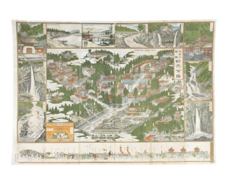
A GUIDE MAP OF NIKKOJapan, Meiji periodPrint in colours on paper.58 x 82,2 cmNote: An identical map, dated to 1900, was exhibited in 2018 at the Volkenkunde Museum of Leiden, The Netherlands, as part of a show entitled "Mapping Asia".[INTERNET KEYWORDS] CHINA, CHINESE, QING, ANTIQUE, CERAMIC, PORCELAIN, PAINTING, SCROLL, JADE, DYNASTIE, JAPANESE, VIETNAMESECondition Report: Condition report:- originally folded;- later on laid on canvas;- folds;- a few minor missing parts.

A collection of engraved and hand coloured maps of Essex, comprising 'A Correct Map of the County of Essex', an Ogilby style map of London to Harwich, an Ogilby style map of Chelmsford to Ingatestone, 'A New Map of Essex Drawn from the latest Authorities', a modern printed map entitled 'Witham and Maldon, Places of Interest', 'Essex' by Robert Morden and sold by A Swall and A .Churchill, 'Essexia Comitatvs Qvem' by Saxton-Kip, and three others (10)Condition report: All maps with areas of discolouration/fading but display well.

A collection of engraved and hand coloured maps, comprising 'An Accurate Map of the County of Northampton' by Bowen, 'A Map of the County of Northampton' by Richard Brome, 'An Accurate Map of the County of Huntingdon' by Bowen, 'Huntington both Shire and Shire Town' by John Speed, 'Bedfordshire Comitatvs' by Blaeu, 'A General Plott and description of the Fennes and surrounded grounds' inscribed 'Amstelodami Sumptibus Henrici Hondii, 1632'Condition report: All maps framed with signs of discolouration and fading. All display well.


Zwei historische Landkarten von Böhmen und Preussen, 1. H. 19. Jh., Stahlstichkarte ''Prussia'' von Johnston aus dem ''National Atlas'' um 1845, hinter Glas (defekt) u. Pp. ger., sowie ''New Map of Bohemia and Moravia by John Cary 1801'', teilkol. Kupferstich, Randläsuren, unger., Rahmenmaße der Preussenkarte 60 x 71 cm
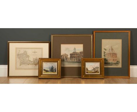
Ken J Messer (1931-2018), The Radcliffe Camera and the Sheldonian Theatre, watercolour and ink, both signed, framed and glazed, 19cm x 27.5cm and 22cm x 22.5cm; Gerald Hughes (1920-2016), 'Spriggs Holy View' and 'Copse near Quainton', oil on board, both signed and dated '78, framed, 13cm x 10cm; and a map of Berkshire, engraved by J Cary, framed and glazed, 26cm x 22cm (5)


A 19th century engraving of The County of Hartford by C & J Greenwood, engraved by J & C Walker, framed and glazed, 74cm x 60cm; together with a copy of A New and Accurate Map of Africa by Eman Bowen, framed and glazed, 43.5cm x 35.5cm (2)Condition report: Map of Hartford with tear to the centre top, some small marks; map of Africa discoloured


-
109182 item(s)/page