We found 109182 price guide item(s) matching your search
There are 109182 lots that match your search criteria. Subscribe now to get instant access to the full price guide service.
Click here to subscribe- List
- Grid
-
109182 item(s)/page


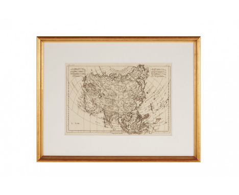
Lot 11
A SWISS MAP OF ASIA (1780) Donated Anonymously Publisher: J L Pellet, Geneva From "Atlas de toutes le parties connues de Globe" prepared by Rigobert Bonne Monsoon winds, essential for trade and explorations, are marked with arrows 22.5cm x 32.5cm Condition: Fold as issued Additional Information: Monsieur Bonne was a French cartographer, Ingénieur-Hydrographe de la Marine, appointed in 1773 by the King Louis XV to succeed J.N.Bellin. He prepared a large collection of maps for several publishers, Raynal and Desmarest among them. His maps do not show decorative cartouches so common in the 18th century however they were appreciated for the details and reports of the newly discovered regions of the world.
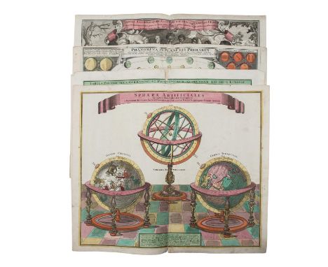
Lot 31
Konvolut außergewöhnlicher, handkolorierter Kupferstiche, 18./19.Jh. - 1 x Windkarte,"Tabula Anemographica seu Pyxis Nautica, vulgo Compass. Charte", Matthäus Seutter. 1 x Altkolorierte Himmelskörperkarte "Phaenomena in planetis primariis", Johann Gabriel Doppelmayr. 1 x "Sphaerae Artificiales" mit Erdglobus, Himmelsglobus und einer ptolemäischen Armillarsphäre, M. Seutter. 1 x "Tabula Poliometrica Germaniae ac Praecipuroum Quorundam Locorum Europae" mit aufwendiger Titelkartusche "Neu vermehrter curioser Meilen-Zeiger der vornehmsten Städte in Europa besonders in Teutschland", Homann Nürnberg. Stets Folioformat mit Mittelfalz. Mit deutlich erkennbaren Alters-und Gebrauchsspuren, Tönung, Flecke, Knicke, Einrisse, restauriert/geklebt. Am besten besichtigen !| Mixed lot of extraordinary, hand-coloured copper engravings, 18th/19th cent. - 1 x Wind Chart, "Tabula Anemographica seu Pyxis Nautica, vulgo Compass. Charte", Matthäus Seutter. 1 x Old coloured map of the heavenly bodies "Phaenomena in planetis primariis", Johann Gabriel Doppelmayr. 1 x "Sphaerae Artificiales" with terrestrial globe, celestial globe and a Ptolemaic armillary sphere, M. Seutter. 1 x "Tabula Poliometrica Germaniae ac Praecipuroum Quorundam Locorum Europae" with elaborate title cartouche "Newly Increased Curious Mileage Pointer of the Most Noble Cities in Europe Especially in Germany", Homann Nuremberg. Always folio format with centrefold. With clearly visible signs of age and use, toning, stains, creases, tears, restored/glued. Best to visit !

Lot 1188
Swinburne Henry: Travels Through Spain in the years 1775 and 1776. 1787 London. Two volumes. Folding plates. Full calf binding; Helme Elizabeth: Cortez; or the Conquest of Mexico. 1811 London. New Edition. Folding map. Full tree calf; and Les Vacances en Suisse. Journal ... Par St. Germain Leduc. 1837 Paris. Two volumes. Full leather binding (5)Condition Report:Not collated so completeness unknown.Noted lacking frontispiece to Swinburne volume one which is also very 'shaky'.Some staining to pages of Helme.


Lot 200
A Japanese Satsuma Fukurokuju (Lucky God of Wisdom) wearing a robe, having a staff & scroll, inscribed to base 'Hokorokuzo', 25cm high & a Noritake porcelain bowl, decorated with a Japanese soldier, bayonet mounted in a winter landscape with map, fac tory printed marks to base, include 1936, 21cm diameter (2)


Lot 30
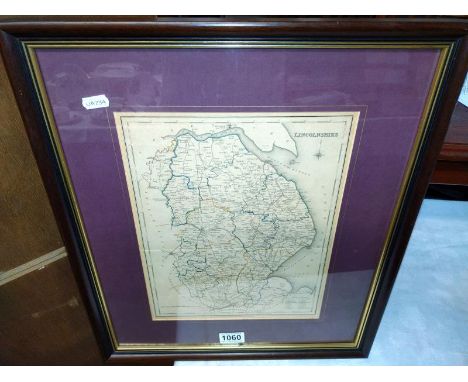
18TH CENTURY MAP OF GLAMORGANSHIRE, Kitchin (Thomas), "An Accurate Map of Glamorganshire", pub. J.Tinney 1754, double page engraving with later hand colouring, title and dedication cartouches and Carrdiff vignette, 36 x 54.5cms; together with a facsimile map of Dame Venodotia, Alias Modryb Gwen; A Map of North Wales (2)


Lot 271
Emanuel Bowen (British, 1693-1767), A New and Accurate Map of Savoy Piemont and Montserrat Exhibiting the Present Seat of War, coloured, 35 by 43cm, framed; together with A Map of the Provostship and Vicountry of Paris....Royal Academy of Sciences by De Lifle, London 1713, coloured, 50 by 62cm, framed (2)


Lot 1277
An interesting collection of maps, including Morden's Kent, a survey of the parliamentary borough of St. Marylebone by Davies, 1834, a new map of the East India Isles by Carey 1801, with six other framed and glazed maps, a small quantity of other unframed maps and a later watercolour on silk of birds amongst blossoms


Lot 61
SOL LEWITT (1928-2007)R715 Map of London with the area between Buckingham Palace, Hyde Park Speakers Corner, Trafalgar Sq., St. Paul's, and Westminster Abbey removed 1977 signed, titled and dated 1977pencil and ink on cut paper map57.2 by 88.7 cm.22 1/2 by 34 15/16 in.Footnotes:ProvenanceLisson Gallery, LondonAcquired directly from the above by the present owner in 1978For further information on this lot please visit Bonhams.com

Lot 7
SYLVIE FLEURY (B. 1961)Mushroom (Colour Map E5 Rage xtc AG) 2006-2011 signed, numbered 1133 and stamped 46 on each partfibreglass and metallic car paint, in two parts130 by 110 by 110 cm.52 3/16 by 37 13/16 by 37 13/16 in.This work was executed in 2006-2011 and is unique.Footnotes:ProvenanceCollection of the artist, GenevaSale: Sotheby's, Paris, Art Contemporain, 3 December 2014, Lot 108Acquired directly from the above by the present owner'Fleury's works deal in binaries: male and female, producer and consumer, yin and yang [...] Phallic objects such as rockets or mushrooms are dyed in cheerful colours like pink or purple, coated with a shiny surface, or supplemented with a playful faux fur, all elements that serve to disarm. [...] In her work one can recognise allusions to canonical artworks by twentieth-century male artists which are given an overtly feminine makeover: Fleury references with playful ease works by Andy Warhol, Lucio Fontana, Victor Vasarely [...] She counters the dominant male position in art history (particularly Pop Art and Minimalism) with female humour'Fabiola Son This lot is subject to the following lot symbols: ** VAT on imported items at a preferential rate of 5% on Hammer Price and the prevailing rate on Buyer's Premium.For further information on this lot please visit Bonhams.com

Lot 1
NO RESERVE Africa.- Life and Explorations of David Livingstone (The), chromolithograph frontispiece and additional title, plates, map, scattered spotting, original decorative morocco, gilt, rubbed, bumping to corners and extremities, Accrington, Daniel Chadwick, c.1880; and another edition of the same, 4to (2)
Lot 152
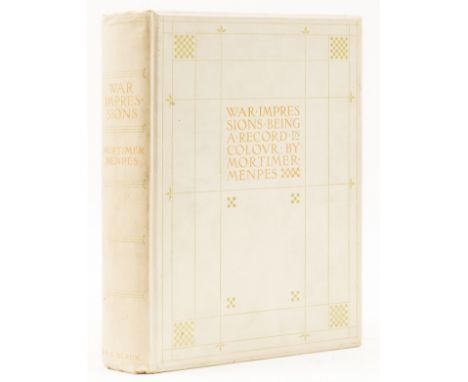
Menpes (Mortimer) War Impressions, one of 350 copies, signed by the author, 97 colour plates, with captioned paper guards, 6 letters in facsimile, folding map (loose), gutter split at p.66 and 115 (interim section loose or coming loose), original decorative cloth, gilt, spine very lightly toned, some light finger soiling to covers, t.e.g., others uncut, 4to, [1901]
Lot 17
NO RESERVE London.- Smith (Albert) Gavarni in London: Sketches of Life and Characters, additional pictorial title and wood-engraved plates by Vizetelly after Gavarni, some light spotting, one plate trimmed, original pictorial cloth, rebacked in morocco, spine gilt, new endpapers, 1849 § Taylor (J.G.) Our Lady of Batersey, plates, folding colour map, original buckram, spine faded, 1925 § Chancellor (E.B.) Historical Richmond, Subscriber's Copy, original roan-backed cloth, gilt, 1885 § Halliwell (J.O.) Rambles in Western Cornwall..., contemporary calf, gilt, by Hodgson of Liverpool, 1861 § Traveller's Album and Hotel Guide (The), wood-engraved illustrations, numerous advertisements, original cloth, gilt, [c.1862], all rubbed; and a bundle of old guides to the Tower of London, Palace of Westminster etc., and a large late 19th century scrapbook of programmes, menus & seating plans for livery dinners, posters & fliers for church services etc., mostly relating to London, v.s. (11)
Lot 2
America.- Adams (John Quincy) The Jubilee of the Constitution. A Discourse., lithograph frontispiece, previous owner's ink name-stamp to title, scattered spotting, contemporary morocco-backed boards, upper cover detached, defective backstrip, rubbed and worn, New York, 1839 § Dodge (Colonel Richard Irving) Our Wild Indians, portrait frontispiece, plates, of which 6 colour, original decorative cloth, sunned spine, slight bumping to corners and extremities, Hartford, Conn., 1883 § A Short Narrative of the Horrid Massacre in Boston, frontispiece, folding map at end, spotting, original cloth, small gauge to upper cover, chipping to corners and spine extremities, New York, 1849 § Smith (Joshua Hett) An Authentic Narrative of the causes which led to the Death of Major Andrè ..., engraved frontispiece and one plate, folding map, scattered faint spotting, contemporary boards, rebacked, rubbed, bumping to corners and extremities, 1808; and another, America, v.s. (33)

Lot 232
Golden Cockerel Press.- Flinders (Matthew) Narrative of his Voyage in the Schooner Francis 1798..., number 375 of 750 copies, printed in green and black on pale grey paper, map, wood-engravings by John Buckland Wright, 1946 § Rutter (Owen, editor) First Fleet (The). The Record of the Foundation of Australia..., number 55 of 375 copies, wood-engravings by Peter Barker-Mill, 1937, the second with slight tape-marks to corners of free endpapers, original pictorial cloth, gilt, the second with inset panel, uncut, small folio, Golden Cockerel Press (2)
Lot 32
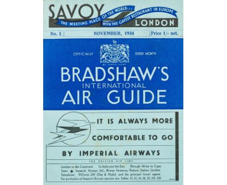
NO RESERVE Aviation.- Bradshaw's International Air Guide No.1, folding colour map loose in pocket at end, with bookmark but detached from cord, original printed blue wrappers, a little very light spotting, 8vo, Henry Blacklock & Co., London & Manchester, November 1934.⁂ An excellent copy of this fascinating and informative early guide to both domestic and international flights.
Lot 92
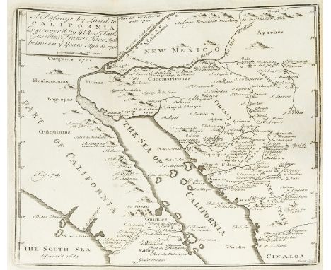
Jones (Henry) The Philosophical Transactions Abridg'd, vol. 5 only, 29 folding engraved plates, maps and tables, bookplate of L. H. King-Harman, small loss to 3H3 affecting a few words, some foxing and browning to text, contemporary panelled calf, spine gilt with tan morocco label, additional paper label and ink markings, lightly rubbed, upper cover with patch of discolouration, joints split at head, G. Strahan & others, 1721; and 8 others of The Philosophical Transactions Abridg'd, vol. 1-4, 8, 9, and two copies of vol. 10, 4to (9)⁂ Contains an early copy of Eusebio Francisco Kino's famous map of California, first published in 1702. Kino's map was the first to show California as a peninsula and not an island, as had previously been suspected.


Lot 116
BOX OF STAMPS IN TWO ALBUMS AND LOOSE, we note a few presentation packs, but the main value is in folio of loose leaves with mint stamps that have adhered to pages inc falkland Islands 1938, 1952 and 1960 sets, 1948 RSW set, FID 1954 set, South georgia 1963 set to £1 Whale, BAT 1963 set to £1 map etc

Lot 164
A BOX CONTAINING WORLD WAR TWO MEDALS, CAP BADGES AND EPHEMERA, to include, 1939-45, Burma Stars, Defence & War Medals, together with four Cap badges, RAC, 3rd Carabenieres, two x York & Lancaster Regt, three x Coronation & Jubilee Medallions and lots of original documents, Soldiers book etc relating to Trooper 7963387 Rex Horsfall Royal Armoured Corps, including a poor quality copy of the Star War Map, also included is a WWI British War Medal, named 203827 Pte E Horsfall, W York Reg't
Lot 173
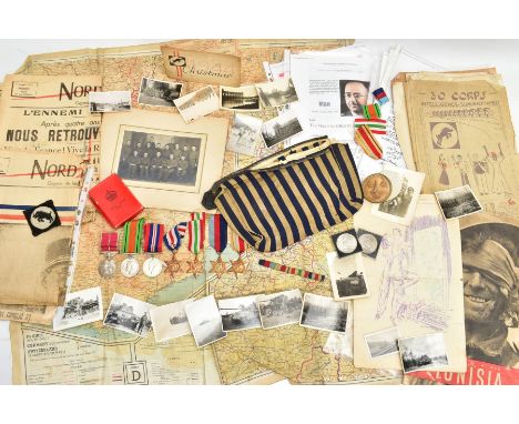
THE SIGNIFICANT AND WELL DESERVED BRITISH EMPIRE MEDAL GROUP TO A WORLD WAR TWO VETERAN, WHO SERVED IN THE NORTH AFRICA, ITALY, & NORTHERN EUROPE CAMPAIGNS, INC GERMANY & SERVED WITH THE INTELLIGENCE CORPS, BEING ONE OF THOSE FROM 45 SECTION F.S.S. WHO WERE INVOLVED WITH THE ARREST, DETENTION & INITIAL INTERRORGATION OF HEINRICH HIMMLER, 135702 A/W.O. Class 2 Grenville GRAYER, group is as follows, all loose ready for wear or mounting, British Empire Medal GRI plain cypher in original box of issue, named 135702 AWO CL 2 Grenville Grayer. I.C. (Intelligence Corps) 1939-45, Africa, Italy, France & Germany Stars, Defence & War Medal. All un-named as issued, with this group is an original Shoulder Cloth Insignia Patch for Thirty Corps and a Bronze coloured Souvenir Medallion celebrating 30 Corps, struck in Belgium, with its original box, GRAYER joined the Army in 1939 and initially served with the R.A.S.C., but sometime between the North Africa/Sicily/Italy Campaigns Grayer returned to the UK and joined the Newly formed Intelligence Corps, completing his training in Scotland attached to the 45th Field Security Section, by this time with the rank of Sgt, working with amongst others a Sgt Britton, who would feature heavily with Grayer and his section at the end of the War, like thousands of other allied troops the Intel Corps, were heavily involved in the preparations for D-Day, Grayer entered the Invasion on D-Day +2 (June 8th, 1944) and would see action and involvement whilst serving in 30 Corps, Commanded by Leuit-General Sir Brian Horrocks, who would achieve fame for his valiant efforts in Operation Market Garden in September, 1944, as the War progressed and German forces retreated Grayer and 45 FSS found themselves in Northern Germany when the Nazi's surrendered in May 1945, During the morning of May 20th, 1945, a group of five German officers and seven other ranks were detained at the Bridge control at Bremervorde, they were handed over to 45 FSS for checking etc, It became apparent that three further Germans were in the vicinity and on May 22nd they were taken into custody by Sgt Britton and NCO’s from the section at the same check-point, information from immediate relatives of Grayer point to the fact one of the Germans, looked suspicious, and although he had recently issued papers stating he was a Sgt Heinrich Hizinger, Grayer was suspicious and this resulted in his initial questioning, Hizinger was asked to write a page of ‘lines’ to test his handwriting etc, the papers he was in possession of also caused concern as it was known that high ranking Nazis were copying these papers to avoid their true identities, during this time of Detention, Hizinger eventually revealed his true identity and whilst being examined by a Doctor, bit down on a cyanide capsule resulting in his death, Grayer liberated the following two items as ‘Tropaion’ or Trophies of War, page of written lines, written by Himler whilst being detained, Silk Toiletry bag in blue/cream coloured material, recovered from Himmler's possessions, the archive also includes an original photo of the recipient with colleagues from 45 F.S.S. Intel Corps, original papers and folder of paperwork from 30 Corps Intelligence Summary No 500 includes many intercepts showing life at the front from the German perspective, many other items of papers, photos, forms etc, include a photocopy of the arrest report of Himmler, which was signed by those present, including Grayer, a wealth of other paperwork including media from the time one photo showing Grayer, from the paper Nord Eclair September 1944, also present is a large double side silk Escape style map, all things considered an amazing archive
Lot 225
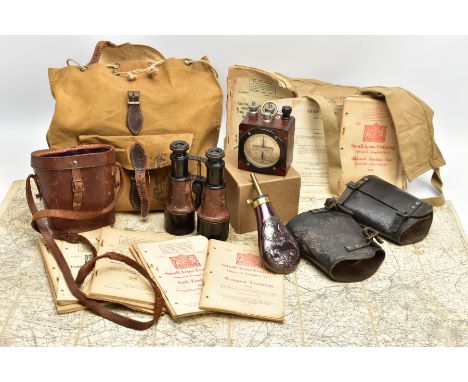
A BOX CONTAINING WWII/POST WWII field equipment, namely a shoulder bag with lots of military handbooks, pamphlets etc, a 1974 dated British Webbing belt, possibly for ammo carry, WWI era binoculars in brown leather case 'Service model', a metal and brass powder flask, fold up large map of France & Flanders WWI and a boxed WWII 1942 dated WGP WA0275 meter


-
109182 item(s)/page