We found 109182 price guide item(s) matching your search
There are 109182 lots that match your search criteria. Subscribe now to get instant access to the full price guide service.
Click here to subscribe- List
- Grid
-
109182 item(s)/page


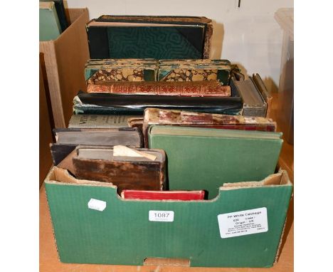
Lot 1087
Wilde (Oscar). The Ballad of Reading Gaol. By C. 3. 3., 2nd edition, London: Leonard Smithers, 1898. 8vo, original cloth, edges untrimmed, bookplate (Robert Ellis Cunliffe), together with an assortment of about 20 other books and ephemera, including: 1) Les poésies d'Anacréon, et de Sapho, traduites en françois, avec des remarques, par Madame Dacier. Nouvelle édition, Amsterdam: widow of Paul Marret, 1716, 8vo, contemporary sprinkled calf, engraved frontispiece, 2) Beck (Thomas Alcock). Annales Furnesiennes. History and Antiquities of the Abbey of Furness, 1st edition, London: Payena and Foss, 1844, 4to, contemporary morocco (binding defective, initial leaves loose), 3) Mozart (Wolfgang Amadeus). XII sonatines pour la pianoforte avec accompagnement de violon, et VI canons, Leipzig: Breitkopft and Härtel, c.1850, oblong folio, contemporary half calf, engraved series-title, 4) Stutfield (Hugh E. M., & J. Norman Collie). Climbs and Explorations in the Canadian Rockies, 1st edition, London: Longmans, Green and Co., 1903, 8vo, original cloth, plates, folding map (repaired verso), 5) A notebook of manuscript music, c.1770, oblong 8vo, approx. 50 leaves (qty: 1 box) The lot sold as seen, not subject to return.


Lot 186
NO RESERVE Institute of Sociology.- Le Play House.- Collection of pamphlets relating to Le Play House, 12 pamphlets, ex-library copies with Le Play House stamps and markings, original wrappers or cloth, some faded, some corners bumped, c.1905-1945.⁂ Including a Map of Czecholsovakia compiled by the Military Cartographical Institute, 'Shall this War End German Militarism?' by Normon Angell, and a Short Review of Angriculture and Forestry in Norway by O. T. Bjanes, 1921, amongst others. Le Play House was set up at the beginning of the Regional Survey Movement in Britain, which aims were to carry out of regional and civic surveys and carrying out the notion of 'civil betterment', stemming from Victor Branford's political philosophy. he Regional Survey, or 'Regionalism', which "lays stress upon family life, contacts with nature, the significance of labour, the interests of locality" was one of three interrelated schools of thought prevalent in the world at the time which they commend. The second was 'Humanism', which "sees the progress of mankind as an unfolding of ideas and ideals ... a view of life and the world inimical to the Prussian cult of force"; and the third 'Civism' or "constructive betterment ... child welfare ... repair and renewal of historic cities ... tidying up of confused industrial towns ... guidance and gardening of their suburban growth".

Lot 244
Portugal.- Eliot (William Granville) A Treatise on the Defence of Portugal, second edition, 5 folding engraved maps, 1 map with small tear repaired and another with small holes in margin, bookplate of Sir Charles Wolseley Bart. on front pastedown, contemporary calf, gilt, slightly rubbed, joints splitting, gilt spine, 8vo, 1811.
Lot 247
NO RESERVE Britain.- Falle (Rev. Philip) An Account of the Island of Jersey, ex-library with occasional ink-stamps, abrasion mark to front free endpaper where label removed, modern cloth, Jersey, Richard Giffard, 1837 § The Rivers of Great Britain ... Rivers of the East Coast, engraved frontispiece, illustrations, newspaper clippings pasted to endpapers, occasional faint spotting, ex-library with occasional ink-stamps, original cloth, shelf label to spine foot, chipping and small loss to spine extremities, 1889 § North (I. W.) A Week in the Isles of Scilly, lithograph frontispiece and 3 plates, ex-library with occasional ink and blind-stamps, abrasion mark to front free endpaper where label removed, previous owner's ink signature to blank, later morocco-backed boards, Penzance, 1850 § Rhodes (E.) Peak Scenery; or, the Derbyshire Tourist, folding engraved map frontispiece, illustrations, ex-library with labels and occasional ink-stamps, modern cloth, 1824 § Curtis (Rev. J.) A Topographical History of the County of Leicester, folding engraved map frontispiece, previous owner's ink signature to blank, ex-library with label and occasional ink-stamps, near contemporary half-morocco, paper label to upper cover, a little rubbed, 1831; and others similar, 8vo & 4to (13)

Lot 250
Northamptonshire.- Britton (John) and Edward Wedlake Brayley. Northampton; or Original Delineations, Topographical, Historical, and Descriptive, engraved folding map and 7 plates, ink ownership inscription to head of title, some offsetting, contemporary half calf, spine gilt and with red leather label, rubbed and little scuffed, J. Harris, 1818 § The History of Northampton and its vicinity : brought down to the present time. Embellished with a beautiful view of Queen's cross, engraved frontispiece, this little foxed, occasional spotting, new endpapers, modern cloth, Northampton, for W. Birdsall, 1815; and 12 others, Northamptonshire, v.s. (14)

Lot 252
Scotland.- Road maps.- Taylor (George) Taylor & Skinner's Survey and Maps of the Roads of North Britain, or Scotland, folding engraved pictorial title with dedication to the Duke of Argyll and his coat-of-arms, map of Scotland, and 61 road maps on 31 sheets, folding letterpress index, map of Scotland with split at fold, a few short tears, and a little marginal loss at head, 1 road map loose, occasional split at fold, some spotting or staining, contemporary reversed calf, rubbed and scuffed, large 8vo, for the Authors, 1776.
Lot 258
NO RESERVE Birds.- Smythies (Bertram E.) Birds of Burma, first edition, frontispiece and 30 colour plates with captioned tissue-guards, folding map, some plates trimmed not affecting image, contemporary calf, light rubbing, short crack to upper joint, spine faded with light spots, 8vo, Rangoon, 1940.
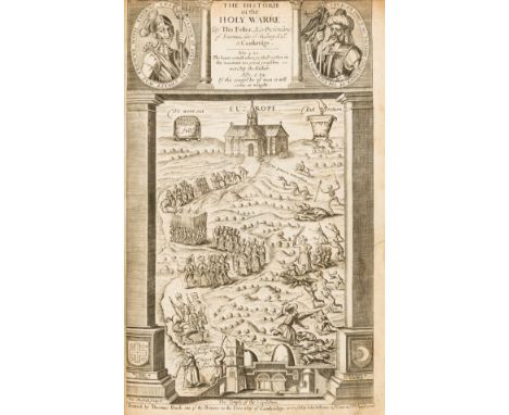
Lot 51
Fuller (Thomas) The Historie of the Holy Warre, first edition, additional engraved title, engraved folding map, both with marginal tears and paper repairs to verso, small marginal tear and paper repair to front endpaper, occasional spotting and staining, light marginal browning, endpapers renewed, contemporary calf, rebacked, small worm damage upper cover, [STC 11464], 8vo, Cambridge, Thomas Buck, 1639.
![[Swift (Jonathan)] Travels into Several Remote Nations of the World... by Captain Lemuel Gulliver, vol.1 only (of 2), 2 parts](https://cdn.globalauctionplatform.com/c00cc4ac-0237-4e2f-84fe-ada20119152e/ba891829-9184-41d4-baf9-ada2011c403e/468x382.jpg)
Lot 66
[Swift (Jonathan)] Travels into Several Remote Nations of the World... by Captain Lemuel Gulliver, vol.1 only (of 2), 2 parts in 1, first edition, Teerink's 'B' edition, engraved frontispiece in second state with vertical chain-lines, 2 engraved plates, woodcut initials, head- & tail-pieces, some light foxing or browning, faint contemporary ink signature "?Ed. Wyatt 1727" to front free endpaper, modern calf preserving old calf lower board (rubbed), spine ruled in gilt, for Benj. Motte, 1726 § Travels into Several Remote Nations of the World...Vol.III, 2 parts in 1, first edition of the spurious third volume, half-title, with pp.112-120 in part 1 misnumbered "110-118", lacking engraved frontispiece but with engraved plate and engraved map from vol.2 of the genuine work (plates V & VI) bound in, occasional browning, a few stains, contemporary panelled calf, rubbed, rebacked with gilt spine and red morocco label, 1727; and a rather foxed and stained copy of Teerink's AA first edition of vol.1 with second state frontispiece, [Teerink 291, 292, & 290; Rothschild 2108], 8vo (3)⁂ The second item is the famous pirated work containing 'A Second Voyage to Brobdingnag', 'A Voyage to Sporunda' (both imitations), and 'A Voyage to Sevarambia, &c.' taken from an earlier work by Denis de Veiras of 1675-9.
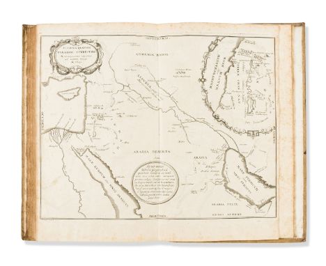
Lot 9
Plinius Secundus (Gaius) Historiæ Naturalis Libri XXXVII, 2 vol. in 3, edited by Jean Hardouin, 1 folding engraved map, 11 engraved plates of coins, engraved initials and head- and tail-pieces, occasional spotting, small marginal rust hole (4X1, vol. 1), small holes affecting text (7O1 & 8N1, vol. 2), previous owner's ink inscription, contemporary vellum, titles to spines in manuscript, light soiling, slight bumping to corners and spine extremities, folio, Paris, Antonii-Urbani Coustelier, 1723.

Lot 94
NO RESERVE Judaica.- Josephus (Flavius) The Genuine Works, translated by William Whiston, 6 vol., folding engraved map, offsetting on to title and vice versa, some spotting, mostly lightly browned, occasionally a little heavier, contemporary speckled calf, spines gilt and with morocco labels, some chipping, marked in places, rubbed, 8vo, Edinburgh, Printed for Mundell, Doig, and Stevenson, 1809.⁂ A solid set of this rare edition. Provenance: Lt-Col George McL. Sceales (modern armorial bookplates).


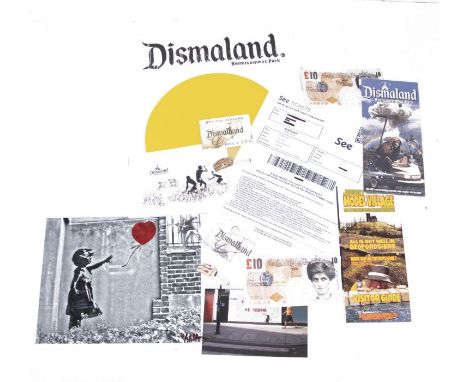
Lot 3316
BANKSY (BRITISH B.1974) - Dismaland, a Bemusement Park Official programme; two Di-Faced Tenners, one stamped Dismaland; a Dismaland map of the site; two DIsmaland hands; a DIsmaland postcard; a Banksy pin badge; a Dismaland admission ticket; two reprints of original photos taken of Banksy's street work; a leaflet for Jmmy Cauty's model village

Lot 171
Joseph E Morris hardback book York - with 20 Illustrations from Photographs, 4 Plans, and a Map 1924 published by Methuen & Co Ltd in good condition. Sold on behalf of the Michael Sobell Cancer Charity. Shipping at cost from £4.99 in UK, we can ship a 30kg box for £10 so up to 10 books. Overseas shipping at cost from £7.99


Lot 102
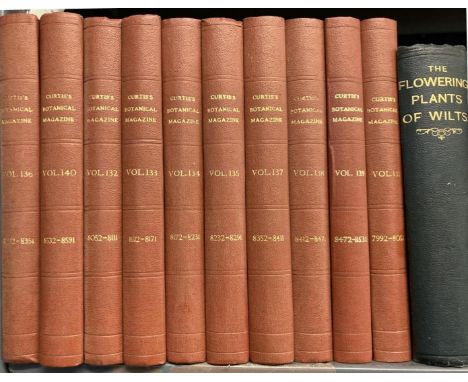
Botany and Horticulture. Curtis, William. The Botanical Magazine, Fourth Series, Volumes 1-10, numerous uncoloured lithographed plates, many folding, modern buckram, 8vo, London: Lovell Reeve & Co., 1905-1914; Preston, T. A. The Flowering Plants of Wilts, folding map, original cloth gilt, 8vo, [Guildford]: Wiltshire Archaeological and Natural History Society, 1888; Barron, Archibald. Vines and Vine Culture, new edition, original cloth, 8vo, London: Journal of Horticulture, 1887; and 60 others, gardening, botany and horticulture, v.s. (72)
Lot 239
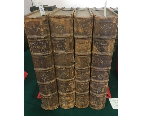
Smollett, Tobias. A Complete History of England, 4 volumes, first edition, engraved frontispieces, folding engraved map, errata leaf at the end of volume one, some browning, contemporary calf, heavily rubbed, joints cracked, bookplate of Coker Court, 4to, London: James Rivington and James Fletcher, 1757-1758
![Blaeu, Willem. Wallia Principatus vulgo Wales, engraved map, hand-coloured in outline, 502mm x 382mm, [c.1645 or later], fram](https://cdn.globalauctionplatform.com/1151d965-7090-44bf-9572-ad9500f4fd1c/895cd54d-6127-4a33-aa63-ad9501169c33/468x382.jpg)

![Coronelli, Vincenzo Maria. Scotia Parte Settentrionale [and Meridionale], 2 engraved maps, lower margin cropped, some tears t](https://cdn.globalauctionplatform.com/1151d965-7090-44bf-9572-ad9500f4fd1c/6cca70d2-db17-4cbe-84dd-ad9501169f35/468x382.jpg)
Lot 356
Coronelli, Vincenzo Maria. Scotia Parte Settentrionale [and Meridionale], 2 engraved maps, lower margin cropped, some tears to fold, repairs, 623mm x 453mm, 1718; Johnston, Andrew. A New Map of the North [and South] Part of Scotland, 2 engraved maps, margins cropped, 453mm x 358mm, c. 1753, and 3 others, similar (7)


![Morden, Robert. Middlesex, hand-coloured engraved map, 422mm x 365mm, [London, Abel Swale et al., c.1722]; Harrison, John. A](https://cdn.globalauctionplatform.com/1151d965-7090-44bf-9572-ad9500f4fd1c/4d8e4d6f-aef6-4ba6-90e4-ad950116a39a/468x382.jpg)
![Mudge, William. London and Middlesex [London and It's Environs], four part folding engraved map, each of 15 sections, backed](https://cdn.globalauctionplatform.com/1151d965-7090-44bf-9572-ad9500f4fd1c/db79515a-fb99-46ba-9e31-ad950116a50b/468x382.jpg)
![Muenster, Sebastian. [Malta] A single leaf from Cosmographia, with a woodcut map of Malta and Gozo upper left, titled 'Melita](https://cdn.globalauctionplatform.com/1151d965-7090-44bf-9572-ad9500f4fd1c/994d8949-070f-42c5-8153-ad950116a5d6/468x382.jpg)


![Speed, John. Somerset-shire Described, hand-coloured engraved map, laid down, 514mm x 382mm, [London]: John Sudbury and Georg](https://cdn.globalauctionplatform.com/1151d965-7090-44bf-9572-ad9500f4fd1c/6f634656-ed00-484a-99d9-ad950116acad/468x382.jpg)

![Speed, John. Cambridgeshire described, engraved map, 523mm x 382mm, Thomas Bassett and Richard Chiswell, [c. 1676]; Norfolk,](https://cdn.globalauctionplatform.com/1151d965-7090-44bf-9572-ad9500f4fd1c/0bfb0f07-8a6c-424a-8f4d-ad950116ae52/468x382.jpg)

Lot 374
Speed, John. Bedford Shire and the situation of Bedford described, engraved map, 508mm x 381mm, Thomas Bassett and Richard Chiswell, [c. 1676]; Hertfordshire described, engraved map, some light browning and staining, small rust-hole affecting image, fold repaired with slight loss to lower margin, 550mm x 380mm, Thomas Bassett and Richard Chiswell, [c. 1676] (2)
![Speed, John. The West Ridinge of Yorkshyre, engraved map, 510mm x 380mm, Thomas Bassett and Richard Chiswell, [c. 1676]; The](https://cdn.globalauctionplatform.com/1151d965-7090-44bf-9572-ad9500f4fd1c/a533dc51-2dd9-4f31-a997-ad950116b02f/468x382.jpg)
Lot 375
Speed, John. The West Ridinge of Yorkshyre, engraved map, 510mm x 380mm, Thomas Bassett and Richard Chiswell, [c. 1676]; The North and East Ridins of Yorkshire, engraved map, occasional rust-marks, fold of lower margin with slight loss, 516mm x 391mm, Thomas Bassett and Richard Chiswell, [c. 1676]; Yorkshire, engraved map, hand-coloured in outline, 508mm x 382mm, Thomas Bassett and Richard Chiswell, [c. 1676] (3)
![Speed, John. The Countye Palatine of Chester, engraved map, 507mm x 382mm, Thomas Bassett and Richard Chiswell, [c. 1676]; Th](https://cdn.globalauctionplatform.com/1151d965-7090-44bf-9572-ad9500f4fd1c/9e96d975-4127-4c1d-9644-ad950116b11b/468x382.jpg)
Lot 376
Speed, John. The Countye Palatine of Chester, engraved map, 507mm x 382mm, Thomas Bassett and Richard Chiswell, [c. 1676]; The Counti of Warwick, the Shire Towne and Citie of Coventre described, engraved map, some ink marks, fold repaired, 519mm x 381mm, Thomas Bassett and Richard Chiswell, [c. 1676]; Stafford Countie and Towne, engraved map, later hand-colouring, lower margin cropped, 504mm x 380mm, Thomas Bassett and Richard Chiswell, [c. 1676] (3)


Lot 381
Sayer. Robert and John Bennett. The Theatre of War in North America, with the Roads, and Tables of the Superficial Contents, Distances, &c, by an American, engraved map, hand-coloured in outline, with letter-press text below in three columns, titled 'A Compendious Account of the British Colonies in North America', surface with some soiling, particularly to lower edge, evidence of folding, with central crease prominent, but now laid-down, 545mm x 745mm approx., London: Robert Sayer and John Bennett, 20th November, 1776, framed and glazedRARE. This broadside was one of the earliest accounts of the Revolutionary War made available to the British public. It enjoyed several printings, the first in March 1776, as the British were evacuating Boston. This appears to be the second printing, with the central cartouche and Florida more prominent.

Lot 57
Anson, George. A Voyage Round the World, In the Years MDCCXL, I, II, II, IV, fifth edition, 42 engraved plates and maps, including folding engraved map frontispiece and 3 large folding charts, occasional light browning, contemporary calf gilt, joints cracked, extremities rubbed, 4to, London: For the Author, 1749
![Barber, J. T. A Tour throughout South Wales and Monmouthshire, 19 [of 20] engraved plates, imprints shaved with loss, double-](https://cdn.globalauctionplatform.com/1151d965-7090-44bf-9572-ad9500f4fd1c/f681c027-363e-4912-810a-ad950115b347/468x382.jpg)
Lot 58
Barber, J. T. A Tour throughout South Wales and Monmouthshire, 19 [of 20] engraved plates, imprints shaved with loss, double-page engraved map, hand-coloured in outline, contemporary calf, upper cover detached, 8vo, London: T. Cadell, 1803; Freeman, G.J. Sketches in Wales, 15 plates, publisher's boards, spine chipped, 8vo, London: Longman, 1826; Davies, J. D. A History of West Gower, etc., 3 volumes, contemporary half calf, worn, 8vo, Swansea, 1877-1885; and 2 others, south Wales (7)
Lot 63
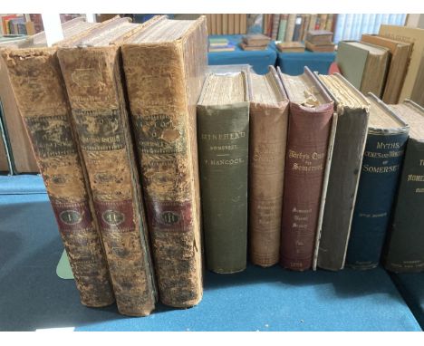
Collinson, John. The History and Antiquities of the County of Somerset, 3 volumes, first edition, engraved plates, without folding engraved map, contemporary calf, worn, covers detached, 4to, Bath: R. Cruttwell, 1791; Lyte, H. C. Maxwell. A History of Dunster, 2 volumes, plates, illustrations, original cloth gilt, 8vo, London: St. Catherine Press, 1909; Hancock, F. Minehead in the County of Somerset, number 137 of 250 copies, plates, original cloth, 8vo, Taunton: Barnicott and Pearce, 1903; and 18 others, Somerset, sold w.a.f., v.s. (24)
Lot 69
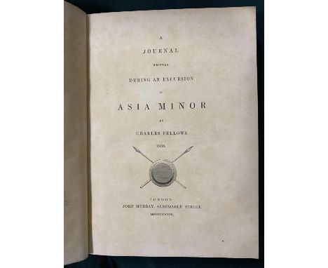
Fellows, Charles. A Journal written during an Excursion in Asia Minor... 1838, first edition, engraved frontispiece, double-page engraved map, 20 lithographed or engraved plates, one double-page, tissue guards, wood-engraved illustrations in text, occasional light browning, contemporary calf, spine gilt, bookplate of Merthyr Guest, 8vo, London: John Murray, 1839

Lot 76
Leighton, John M. Swan's Views of the Lakes of Scotland, second edition, 6 additional engraved titles and 48 engraved plates, light spotting, contemporary half calf, spine cracked, upper cover detached, 4to, Glasgow: Joseph Swan, 1836; Stewart, David. Sketches of the Character, Manners, and Present State of the Highlanders of Scotland, 2 volumes, presentation copy from the author, large folding and-coloured engraved map, contemporary diced calf, spine rubbed, 8vo, Edinburgh: Archibald Constable and Co., 1825 (3)

Lot 77
Lewis, Samuel. A Topographical Dictionary of England, 4 volumes, fifth edition with Atlas, containing folding engraved general map and 56 county maps, some folding, some hand coloured in outline; A Topographical Dictionary of Wales, 2 volumes, third edition, original cloth, vol 4 of England with wear to spine, and 2 other spines chipped, occasional spotting to map margins, 4to., London S. Lewis, 1844. With another copy of the Atlas, containing general map and 44 county maps, and 5 others, v.s. (13)

Lot 85
Savage, James. The History of Taunton, new edition, half-title, engraved frontispiece, 2 folding engraved plates, large folding engraved map, slight browning, contemporary calf, joints cracked, 8vo, Taunton: John Poole, 1822; Escott, T. H. S. Somerset, Historical, Descriptive, Biographical, illustrations, original publisher's morocco, rubbed, 4to, Bournemouth: Mate and Sons, [n.d.]; and 18 others, Taunton, Bridgwater and environs, v.s. (20)
-
109182 item(s)/page