We found 109182 price guide item(s) matching your search

Refine your search

Year

Filter by Price Range
  • List
  • Grid
  • 109182 item(s)
    /page

Lot 150

J. Philp A Panorama of Falmouth 'Containing a History of the Origin, Progress Past and Present State of the Port; particulars of The Packet and other Establishments; Directions to the Public Offices, Taverns, Lodging Houses & descriptions of the walks, rides, aquatic excursions and every object of interest in its vicinity; with a map and other engravings being a complete guide to the town and surrounding country,' 1827, The Cornish Magazine Office for J. Philp. 8vo 90pp (16 P.P.) to the back, a town directory, subscriber's list and ads, One colour plate with signal flags and three fold-out engraved plates, etc. Bound in marbled boards - very scarce.

Lot 159

Weighell’s North Cornwall Guide with map and illustrations, 1889 64 pages including many original advertisements, illustrations and fold-out map, good condition, W. Weighell, Launceston, 1889.

Lot 160

William Roberts Perranporth, Cornwall (north coast) 'Reminiscences of Perranporth from the Year 1833. Its Former Industries: Mines, Fisheries: Names, Personal and General Characteristics (with map),' first edition, 192 pages, hardback, some repairs to map, but otherwise a good clean copy, Oscar Blackford, Truro, 1939.

Lot 19

Cornish Chamber of Mines Year Book, 1920 Edited by Harold E. Fern. First edition, printed by Mining Publications Ltd, London and published by the chamber. All fold out plans/sections collated. Loosely inserted at the back, a map by Harold Fern. First edition, 1920.

Lot 191

William Marshall. 'The Rural Economy of the West of England,' 1796. 'Including Devonshire and Parts of Somersetshire, Dorsetshire and Cornwall. Together with Minutes in Practice,' first edition, 2 volumes, engraved folding frontispiece map, rebound in boards, fine copies, G. Nichol, bookseller to His Majesty, Pall Mall, London, 1796.William Marshall (1745-1818) was born in North Yorkshire the son of a farmer. In the early 1790’s he suggested the formation of a department of rural affairs and a national survey of farming, but both ideas were appropriated by Sir John Sinclair. (2)

Lot 192

F. W. I. Stockdale. 'Excursions in the County of Cornwall'. Illustrated with engravings, comprising a concise historical and topographical delineation of the principal towns and villages, together with descriptions of the residences of the nobility and gentry, with a list of the present representatives in Parliament for the several boroughs of the County of Cornwall with their residences, subscribers list, 50 plates, plus a folding map of the County and an additional plate/frontispiece being an engraving of the author, in original binding hence the spine is shaken, otherwise a very good clean copy, Simpkin and Marshall, 1824.

Lot 205

Copper mining interest. Rowe v Brenton trial, 1830. George Concanen. 'A Report of the Trial at bar, Rowe v Brenton, tried in the Court of King’s Bench, Westmister. Michaelmas Term, 9 geo IV. As to the Right to Minerals in the Assessional Lands of the Duchy of Cornwall, with Explanatory Notes and an Appendix,' first edition, 8vo, 43 prelim and 236 pages with a hand coloured litho map drawn Nov 1827 by Richard Carveth Surveyor, St Austell, with the stamp of Birmingham Law Society, in original boards, the spine needs re-gluing, a little damp staining otherwise a very good copy, W. Walker, London, 1830.The action which forms the subject of the following report, was brought to try the right to Copper Ore raised from the East Crinnis (St Austell) mines.

Lot 214

William Penaluna (Printer and Publisher). 'An Historical Survey of the County of Cornwall, etc,' second edition, 2 volumes, 352 pages and 356 pages respectively, with a map of Cornwall in vol I (not normally seen), 2 folding plates and 7 engraved plates, 'Bibliotheca Cornubiensis' calls for 6 plates only, loosely inserted a signed letter from William Rashleigh, with the engraved bookplate of Jonathan Rashleigh together with his signature and the bookplate of John Blowey, 12mo, in original bindings, gilt lettering to spine together with gilt Prince of Wales feathers, both volumes in good condition, compiled by the printer, 1843. (2)

Lot 215

Brenton Symons. 'A Sketch of the Geology of Cornwall,' 1884. 'Including a Brief Description of the Mining Districts and the Ores Produced in Them,' first edition, with large folding geologically coloured map, 9 steel engraved plates and 2 sectional plates, original green cloth lettered in gilt on the upper cover and spine, a near fine copy, published by the Mining Journal, Fleet St, London and Printed by F. Rodda, steam Printer, Penzance, 1884.

Lot 216

R. Tredinnick. 'A Review of Cornish and Devon Mining Enterprise 1850-1856 Inclusive'. First edition, a hand coloured map of ‘’Buller-Basset group of Copper Mines‘’, folding table, publishers cloth, new endpapers and relaid spine, published by Thompson and Vincent, London, 1857.A description of the most important dividend and progressive Copper and Tin mines in Cornwall and Devon, and a detailed account of the Buller and Basset district May 1st, 1858.

Lot 222

Two histories on Tin mining. John Hatcher. 'English Tin Production and Trade Before 1550,' first edition, signed by Justin Brooke, in an unclipped and unfaded wrapper, 219 pages, tables, charts, bibliography, index, map, 8vo, very good copy of a scarce study, Clarendon press, Oxford, 1973.D. B. Barton. 'A History of Tin Mining and Smelting in Cornwall,' second edition, a very good copy, published by Cornwall Books, 1989. (2)

Lot 25

Arthur G. Langdon. 'Old Cornish Crosses'. First edition, signed by the author, folding map, numerous plates and illustrations in text from drawings, original gilt lettered green cloth, includes an index of crosses and an article on their ornament by J. Romilly, 54 copies of this work was published as a limited edition this is number 18, it is a large paper copy and is signed by the author, with the bookplate of Richard Carlyon Coode (1856-1931), Polapit Tamar, near Launceston, a scarce work,copy in near fine condition, published by Joseph Pollard, Truro, 1896.

Lot 253

Edmund H. Sedding. 'Norman Architecture in Cornwall,' 1909. 'A Handbook to Old Cornish Ecclesesiastical Architecture, With Notes on Ancient Manor Houses with a Chapter on the Old Saints of Cornwall,' first edition, hard cover, 464 pages, white cloth spine with gilt lettering and architectural decoration to green boards, 162 b&w plates, large fold out map to rear, pages uncut, subscribers list showing 123 copies, this is large paper copy, fine condition, Ward & Co, Charing Cross, London, 1909.

Lot 255

Two works with an archaeology interest. H. O’Neill Hencken. 'The Archaeology of Cornwall and Scilly', first edition, a fine copy in original dustwrapper, the county archaeological series, with 9 maps and 59 illustrations, with folding map to the rear, tipped in various newspaper cuttings, handwritten notes from the British Archaeological Assoc Journal, vol 32, 1876, as well as a letter from a lady involved in a later dig on Scilly, Methuen & Co Ltd, London, 1932.Paul Ashbee. 'Excavation of a Homestead of the Roman Era at Halangy Down, St Mary’s, Isles of Scilly,' 14 pages, good copy, University Press, Oxford, 1950. (2)

Lot 1278

19thC School. Map of England with floral border, sampler, 71cm x 69cm.

Lot 4

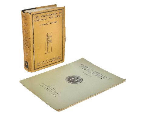
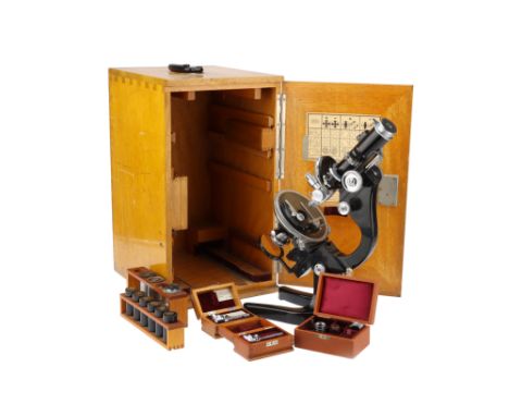
German, c.1936, engraved to the front of the body tube 'Ernst Leitz Wetzlar' and 'GS 280' (Geological Society) and engraved on most parts, objectives and eyepieces 'GS280', numbered on the card in the door 323053 the microscope standing on a large and heavy black enameled base, with locking adjustment to the incline, with plano-concave mirror focusing substage condenser with polariser, focusing stage to be used in conjunction with the vertical illuminator so as not to displace the position of the illuminator in relation to an external light source, stage with large removable central section so the microscope can be used with a Universal Stage, body tube with Bertrand lens (along with a hand-drawn chart ) with rack and pinion focusing, analyser with adjustment and scale, in a large wooden case with 7 Leitz objectives 6 of which are engraved GS280, a Berek Compensator engraved GS280 and engraved 1914 along with a hand-drawn chart (damaged), a cased mechanical stage, another Berek compensator engraved GS619The microscope was sold by the Geological Society back in 1984 to Peter Aubry Sabine for £115.00 and comes with all of the paperwork relating to the sale. According to the records held by the British Geological Society the microscope was bought in 1936 presumably for Dr Phemister, who was recorded as having it in 1937. Dr. Phemister was appointed Official Petrographer in 1935, a post he held until he became Assistant Director in 1946.Dr James Phemister was a renowned geologist whose contributions to the field of earth sciences were significant. He was born in Scotland in 1903 and spent most of his life working as a geologist in the UK. Dr Phemister's expertise in the field of geology earned him a high reputation among his peers and the scientific community.Dr Phemister's career began at the University of Edinburgh, where he earned a degree in geology. He then went on to study at the University of Cambridge, where he obtained a PhD in 1928. After completing his studies, Dr Phemister joined the British Geological Survey, where he worked for over 30 years. During this time, he made significant contributions to the study of geology in the UK.Dr Phemister's work was not limited to the UK, however. He also worked on geological surveys in Africa and South America. In Africa, he worked on a geological mapping project in the Congo, where he discovered the presence of copper deposits. In South America, he worked on a project to map the geology of the Andes mountains, which helped to improve our understanding of the tectonic processes that shape mountain ranges.Dr Phemister was also an active member of the Geological Society of London, where he played an important role in the development of the society. He was elected a Fellow of the society in 1939 and served as its President from 1953 to 1955. During his tenure as President, Dr Phemister worked to increase the society's membership and promote the study of geology.Apart from his work with the Geological Society, Dr Phemister was also an accomplished author. He published several books on geology, including "The Geology of Central England" and "The Geology of the South Wales Coalfield." These books were instrumental in advancing our understanding of the geological history of these regions.Dr Phemister's contributions to geology and earth sciences were recognized by many scientific societies in his lifetime. He was awarded the Wollaston Medal by the Geological Society of London in 1956 for his contributions to the study of geology. He was also awarded the Lyell Medal by the same society in 1966 for his contributions to geological mapping.In conclusion, Dr James Phemister was a pioneering geologist whose contributions to the field of earth sciences were immense. His work on geological mapping and his involvement in geological surveys in Africa and South America helped to improve our understanding of the geology of these regions. His tenure as President of the Geological Society of London was marked by his efforts to promote the study of geology and increase the society's membership. Dr Phemister's legacy lives on through his numerous publications and his lasting impact on the field of geology.Peter Aubrey Sabine, (b.1924 - d.2022) was as a prominent British petrologist and mineralogist born in London in 1924. He graduated with a geology degree from Imperial College London in 1945 and joined the Geological Survey and Museum (GSM) as a Geologist. Early in his career, he helped to reorganize the Geological Museum's specimens and showcases, sparking his interest in igneous petrology. In 1951, he received his PhD for investigating the minor intrusions of the Assynt district in N.W. Highlands. He was later promoted to Chief Petrographer and set about modernizing the Petrographical Department. He realized that the polarizing microscope for the optical characterization of rocks and minerals had been overtaken by more rapid and versatile techniques. He acquired the first X-ray diffraction (XRD) equipment by the late 1950s, followed by X-ray fluorescence (XRF) and differential thermal analysis (DTA) equipment. By the mid-1960s, modern X-ray diffractometer and image analysis equipment were installed, making the Petrographical Department the best equipped and staffed laboratory in the GSM.Sabine conducted various petrological studies, including contact metamorphism of chalk by Tertiary dolerite intrusions, resulting in several seminal publications. He provided the first detailed petrographical description of the granite found on Rockall, a tiny Atlantic island, after the first landing by the Royal Navy in 1955.Sabine was the longest-standing member of the Mineralogical Society at the time of his death, having joined in 1945 and becoming Vice President of the Geological Society in 1966. In 1977, he became Chief Geochemist at the Gray's Inn Road office of the renamed British Geological Survey (BGS) and later returned to the Exhibition Road as Deputy Director. However, he retired at the end of 1984 when the BGS relocated its headquarters to a site near Nottingham. Sabine's legacy includes groundbreaking research and modernization in petrology and mineralogy.

Lot 298

Mila Fürstová (Czech, born 1975): 'True Love I' Artwork From Coldplay's 'Ghost Stories' Album, 2014 , numbered A/P, hand-printed etching with ink and paint on heart-shaped paper, inscribed in ink For Marianne & Mike with love titled True Love and signed and dated 2014 by the artist, on raised mount, framed and glazed, artwork 46 x 40.5cm (18 x 16in). Footnotes: Provenance: Gifted to the vendor by the artist. Lyrically, 'True Love' talks about heartache and how the protagonist can't bear the pain of losing his lover. The song's lyrics were addressed to be about Chris Martin's divorce from his wife Gwyneth Paltrow, a recurrent theme on the whole album. Martin has claimed that 'True Love' is the band's favourite track it has ever written. Fürstová, whose work has been described as 'dazzling images [that] are both contemporary and personal, searching in the surreality of dreams, tales and fables that can map the framework of our consciousness', and has won numerous awards, including the Royal College of Art Society Award in 2001 and becoming the youngest academician at the Royal West of England Academy in 2009, was invited by Coldplay to etch artwork for their new album in January 2013. She described the collaboration between her and the band as 'a most inspiring journey and a truly humbling experience to cooperate with such talented people'. This lot is subject to the following lot symbols: AR AR Goods subject to Artists Resale Right Additional Premium. For further information on this lot please visit Bonhams.com

Lot 216

The 2017 South African mint fractional Krugerrand gold proof coin set,comprising 1/4oz, 1/10oz, 1/20oz and 1/50oz coins, in box, with certificate of authenticity together with a gilt bronze medallion depicting a map of Africa inset with a 0.03 carat brilliant cut diamond

Lot 368

The Silver map of Great Britain, authorised by the Council for the Protection of Rural England on the occasion of its Golden Jubilee, the map is etched on silver and embellished with 24 carat gold, the edge decorated with Coats of Arms, No.1709/3000 with certificate

Lot 72

Christopher Saxon, A hand coloured engraved map of Denbigh, 10" x 12.25", (26x31cm).

Lot 77

Wenceslaus Hollar, Map of England and view of Prague with scenes of the beginnings of the Civil War, 17th Century engraving, 11.5" x 13.75", (29x35cm) (unframed) (a/f).

Lot 66

TALISKER 10 YEAR OLD MAP LABEL ISLAND SINGLE MALT Even by today’s standards Talisker distillery is a bit out of the way, nestled on the shore of Loch Harport on the west coast of the isle of Skye. This might explain why, in its early days, the distillery frequently changed hands, with owners struggling to turn a profit. It wasn’t until owner Roderick Kemp oversaw construction of a pier in the late 19th century, allowing much easier access for the boats that transported the casks to the mainland, that the distillery’s fortunes began to improve.Despite a minor stumbling block in 1960 when the distillery burned down and had to be completely rebuilt, it has grown to become one of the most recognisable single malt brands in the world.45.8% ABV / 70cl

Lot 131

TALISKER 10 YEAR OLD MAP LABEL ISLAND SINGLE MALT Even by today’s standards Talisker distillery is a bit out of the way, nestled on the shore of Loch Harport on the west coast of the isle of Skye. This might explain why, in its early days, the distillery frequently changed hands, with owners struggling to turn a profit. It wasn’t until owner Roderick Kemp oversaw construction of a pier in the late 19th century, allowing much easier access for the boats that transported the casks to the mainland, that the distillery’s fortunes began to improve.Despite a minor stumbling block in 1960 when the distillery burned down and had to be completely rebuilt, it has grown to become one of the most recognisable single malt brands in the world.45.8% ABV / 70cl

Lot 121

A Rare American Colonial Map Powder-Horn Signed Arthur Nicolson, Dated 1758 The body formed from a section of polished natural cowhorn incised with scrimshaw work depicting the forts and settlements along the Hudson and Mohawk rivers from New York up to Canada, with views including New York, Albany, Still Water, Fort Edward, Lake George, Fort Carilion, Fort Pepperell and Lake Ontario, the Hanoverian royal arms and shipping, and tapering nozzle with turned moulding and silver cap, the reduced base now converted to a snuff mull with hinged silver-mounted cowhorn lid (minor damage) set with a faceted paste, an applied silver plaque on one side engraved 'FROM J. Grant Esq. DUNEANE TO D. Mac P. 1844' 28.5 cm. Footnotes: For a related flask also converted to a snuff mull see Christie's London, Fine English & European Firearms, Arms & Armour, 19 December 1961, lot 193 For further information on this lot please visit Bonhams.com

Lot 220

Pictures and Prints - A R Quinton, The Annals of Hampstead, assorted prints; others similar; late 19th century engravings, Derbyshire scenes, Silk Mill, map, Peveril Castle, Markeaton Hall, St Alkmunds, etc; Tintern Abbey, Menai Bridge; qty

Lot 773

STOW (J), A SURVEY OF THE CITIES OF LONDON AND WESTMINSTER AND THE BOROUGH OF SOUTHWARK, 2 vols, 6th edition, with 132 engraved maps and plates, full mottled tan calf, bookplate for Henry Carington Bonles, London, W. Indy's, 1754 (2).Condition Report: Frontis folding map to vol 1 is re-backed with a chip to the original paper to the bottom left, a small loss in Green Park, small loss to paper up a vertical fold to bottom right and a tear to the central fold of about 10cm. Internally both volumes are good, with general age wear toning and some minor ages are mostly good, some minor creasing to folded plates. Odd text page with minor tear or chip. Bindings are worn alone all edges, through to the boards at one corner. Wear and losses the tops and bottoms of both spines and the spines appear to be re-backed. Later marbled end papers to inside.

Lot 794

EXCURSIONS IN THE COUNTY OF SUFFOLK: COMPRISING A BRIEF HISTORICAL AND TOPOGRAPHICAL DELINEATION OF EVERY TOWN AND VILLAGE, two vols, folding frontis map and folding town plan, engraved plates, three quarter green leather with marbled boards, London, Longman 1818, (2).

Lot 809

HUME (REV A), ANCIENT MEOLS: OR SOME ACCOUNT OF THE ANTIQUITIES FOUND NEAR DOVE POINT ON THE SEA-COAST OF CHESHIRE, folding engraved map, other plates, some hand coloured and text illustrations, gilt cloth, London, John Russell Smith 1863; IRVINE (F), NOTES ON THE OLD HALLS OF WIRRAL, Liverpool 1903, and various other books on Cheshire and the Wirral including a Kelly's Directory 1928.

Lot 814

A large collection of books on Cheshire and the Wirral including Transactions of Lancashire and Cheshire Antiquarian Society, MORTIMER (W), THE HISTORY OF THE HUNDRED OF WIRRAL, rebound in green cloth, with folding map to front, 1847.

Lot 819

LYSONS (D), MAGNA BRITANNIA BEING A CONCISE TOPOGRAPHICAL ACCOUNT OF THE SEVERAL COUNTIES OF GREAT BRITAIN, vol II only, with folding map of Cheshire, many other maps and engraved plates, later quarter calf with marble boards, 1810; HISTORY, GAZETTEER AND DIRECTORY OF CHESHIRE, 1860 (2).

Lot 902

Five folding maps, comprising two Walker's county maps for Sussex and Monmouthshire; Philips New Railway and Road map for the principality of Wales, north sheet, 51cm x 81cm; a Darton and Sons map of Gloucestershire and an 1850 French Map 'Nouvelle Carte Postal de la Republique (5).

Lot 903

A NEW MAP OF ENGLAND AND WALES, hand coloured sectional folding map printed by C. Smith, 2nd edition, 1808, 58cm x 48cm, with slip case (2).

Lot 904

MOGG'S TWENTY FOUR MILES ROUND LONDON, a hand coloured engraved sectional map, published Jan 1st 1843, corrected, 62cm x 58cm; with a W. H. Smith & Son, hand coloured engraved sectional map, undated, 59cm x 84cm (2)

Lot 905

JAMES WYLDE; A New Map of Europe, hand coloured engraved sectional map, dated 1846, 97cm x 85cm, with slip case (2).

Lot 910

JAMES BRUCE; TO THE KING THIS MAP CONTAINING A CHART OF THE ARABIAN GULF WHICH IS EGYPTIAN, ETHIOPIAN, AND ARABIAN COASTS FROM SUEZ TO BAB EL MANDEB, a hand coloured engraved map, circular 1791, in modern frame, 62 x 50cm.

Lot 911

A collection of vintage road and bicycle maps, etc, to include Bacon's Cycling road map Leamington; Gall & Inglis Tourist map of Scotland - Angus; and PANORAMA PRESO DALLA CIMA DEL MONTE MOTTERONE (Quantity)

Lot 1533

STADLER AFTER ROLANDSON & PUGIN; 19th century hand coloured aquatint, exhibition of watercolour drawings, Old Bond Street, published London 1st September 1808, 26.5 x 33cm, framed and glazed, with a double sided road map from Manchester to Leeds, a French map of Asia, a Stevengraph of two pheasants and various other watercolours and prints.

Lot 1536

ROBERT MORDEN; an 18th century map of Scotland (af), together with a collection of 19th century and later maps and engravings, to include Staffordshire and Derbyshire by Messrs Knight Frank Rutley 1918, etc.

Lot 324

Two folding trench maps of the Somme region, 65cm x 89cm, Sheet 57c S.W., trenches corrected to 5-5-16. 62D N.E., trenches corrected to 25-4-16 and a similar folding map of Lens. With an 'Air poto of Longueval taken July 1916 during the Somme, showing German trenches' exhibited at a War Trophies Exhibition, 1918 at the Coronation Hall Ulverston, lent by Ex. Lieutenant G.S. Ashburner of the 8th K.O.R.L. A lot *Condition: splits to folds, and creases.

Lot 408

A large quantity of mixed Ordnance Survey and Bartholomew Scottish regional maps, with some early examples (including an Ordnance Survey Aviation Map of South West Scotland "Waterproof Sprayed") Condition Report:Available upon request

Lot 258

Stanford, Edward, Map of London With Its Postal Sub-Divisions, mid-late 19th century, part-hand coloured engraved map, dissected and backed on linen, framed, sheet size - 70 x 95cm, frame size - 78.5 x 103cm        

Lot 532

ANTIQUE MAP OF KINGSTON-UPON-HULL 14" X 16”

Lot 81

CARTON WITH QTY OF RUSSIAN POSTERS & AN OLD MAP OF BRISTOL

Lot 468

PAIR OF F/G ORIENTAL SILK PICTURES, BAMBOO FRAMES SAXON MAP OF DEVONSHIRE & A FRAMED PICTURES OF HORSES

Lot 115

After Sebastian Munster, De La Cosmographie Phoenice, coloured engraving appearing a page from a book, together with a map of Europe 'Dell Europa, La Quale Comprend All'. A coloured engraved map 10x14cm approx. (2) (B.P. 21% + VAT)

Lot 149

Saxton and Kip, original map of 'Caermardi (sic)', together with Robert Morden original map of the county of Monmouth, and a framed four panel text entitled 'South Wales, to avoid being tedious we shall describe the twelve counties of Wales under two divisions only etc..'. Framed (3) (B.P. 21% + VAT)

Lot 1609

A VINTAGE MAP OF 'AUSTRALIEN UND POLYNESIEN'

Lot 1631

A VINTAGE 'GEOGRAPHIA' MARKETING AREAS OF GREAT BRITAIN MAP

Lot 496

TWO HALLMARKED BIRMINGHAM SILVER NAPKIN RINGS AND A FURTHER SILVER RING WITH A MAP OF CYPRUS

Lot 992

A FRAMED VINTAGE PRINT OF 'SAXTON'S MAP OF NORFOLK 1574'

Lot 1932

A PINE FRAMED MAP OF NORTH WALES AND MANCHESTER

Lot 236

Price (Luxor), THE QUOKS, first edition, car boards, illustrated cover, alphabet checkerboard endpapers, map frontispiece, monochrome and colour plates throughout, W & R Chambers Ltd, London 1925; with THE WORLD'S FAIRY BOOK, first edition, illustrated by Monro S. Orr, cloth boards with embossed illustrated cover, colour frontispiece, colour plates throughout, George G. Harrap & Co Ltd, London 1930 (2) (at fault)

Lot 265

A 17th century hand coloured engraved map of Kent, c1646, Johannes Blaeu.  French text verso. Mounted and framed in double sided glazed gilt frame. Map size 53cm x 38.5cm. Frame 69cm x 56cm

Lot 850

A framed silver map of Great Britain, approx 50cm x 70cm. Shipping category D.

Lot 1823

A framed map corn wall by Robert Morden .42 by 38 cm NO RESERVE

Lot 78

Bernhard Moritz, Bilder aus Palästina, Nord-Arabien und dem Sinai, comprising 106 plates after photographs of the Middle East, including the holy sites at Mecca Berlin, Dietrich Riemer, 1916106 plates after photographs mounted on to 50 card mounts with printed captions and dates in German, mostly two per mount, the images of varying sizes, numbered 1-100 (1-100 and 16a, 59b, 60a, 72a and 95a, one map, numbered 63a), 10 bound leaves (16 pages) of accompanying text in German, loose as issued in publisher's cloth-backed decorative portfolio boards, gilt-lettered Nord-Arabien und Sinai on upper cover, covers with printed decoration in the style of a Mamluk binding, oblong folio, title mount inscribed in ink R. Tschudi[?] portfolio 310 x 410 mm.Footnotes:A rare photographic record of the major sites and geographic features in Saudi Arabia, Jordan, Syria, Egypt and Palestine. The original photographs were taken for the most part by Moritz between 1905 and 1915, but some by Turkish friends in areas where he was prohibited from going. The subjects consist of:Jerusalem.Landscape views near Jericho and in Jordan.Deraa and other locations in Syria.Bedouin camps in east Jordan.Petra and the landscape nearby.Desert views in the Hejaz.Personnel building the Hejaz Railway between Damascus and Mecca and Medina.One printed map of Medina, accompanying views of the town, including the Mosque of the Prophet and the progress of the Mahmal in 1914.Views of Mecca, including the Ka'ba, and a pilgrim camp near Mount Arafat.Street scenes in Jeddah.Aqaba.Desert views in Sinai, oases, wadis and Christian monastic buildings.Moritz (1859-1939) was an Arabist and archaeologist who from 1896 to 1911 was in charge of the Khedival Library and Archive in Cairo, publishing a seminal work on Arabic paleography in 1905. He made several research trips to the Sinai and Hejaz.For further information on this lot please visit Bonhams.com

Lot 42

Local History - A George III map 'A New Map of the County of Derby Divided into Hundreds'  printed by C.Smith No.172 Strand, London January 6th 1804, 51 x 45.5cms, framed

Lot 421

A set of  bone and ebony dominios;  playing cards;  The Humber Royal Cycle map;  Road Map of Cornwall;  OS one-inch map, Lincoln & Grantham;  Bartholomew's Maps, North Wales, North Somerset, English Lakes;  etc

Lot 111

18th century Robert Morden hand tinted map, The County Palatine of Lancaster, 42.5cm x 37cm;  After Estra Clark (British 1904-1993, Historic York, map pub. Ben Johnson & Co, York 1947, 37cm x 45cm;  After Blaeu Arania, Insula in aestuario Glottae, Theyse of Arren in the Fyrth of Clyd, 37cm x 50cm; The British Isles educational map on plastic (4)

Lot 489

William Kip,Devoniae,a hand-coloured county map,30x34cm,and Christopher Saxton & William Kip, Lecestriae Comitatus, hand coloured map, 28x36cm.Qty: 2Condition report:The colours are rather faded on both maps, particularly the pale pinks, blues and yellows. Please see additional uploaded images.

Loading...Loading...
  • 109182 item(s)
    /page

Recently Viewed Lots