We found 109182 price guide item(s) matching your search

Refine your search

Year

Filter by Price Range
  • List
  • Grid
  • 109182 item(s)
    /page

Lot 60

Australia.- [Maslen (T.J.)] The Friend of Australia; or, a Plan for Exploring the Interior, first edition, 5 lithographed plates, 4 hand-coloured, large folding map, small marginal tear, title and dedication leaf neatly strengthened at edges, faint remnant of ink stamp to title verso, contemporary cloth-backed boards, rebacked with original spine laid down, bumping to corners and spine extremities, [Abbey Travel 574], 8vo, 1830.

Lot 63

China.- Ides (E. Ysbrant) Three Years Travels from Muscovy Over-Land to China thro' Great Ustiga, Siriania, Permia, Sibiria, Daour, Great Tartary, &c. to Peking, first English edition, additional engraved title dated 1705 and 30 plates (8 folding), 1 with short tear to foldline, large folding map, short tear to fold, previous owner's ink signature to title, occasional marginal worming, small loss to lower corner (G4), not affecting text, occasional browning and spotting, later calf, rubbed spine, slight bumping to corners, small loss to spine extremities, for W. Freeman, J. Walthoe, T. Newborough, J. Nicholson, 1706.

Lot 70

Japan.- Charlevoix (Pierre-François-Xavier de) Histoire et Description Generale du Japon..., 9 vol., half-titles and titles in red and black, 8 folding engraved maps and plans including large map of Japan by Bellin, 48 engraved plates, many folding, vol.1 with 4pp. privilege/errata at end, some light browning, a few spots, some maps or plates with short tears at inner edge, old ink library stamp to titles, contemporary mottled sheep, spines gilt with red morocco labels (a couple lacking), a little scuffed and worn, particularly to spine ends, some splits to joints, 12mo, Paris, J.-M.Gandouin, 1736.

Lot 72

Middle East.- Blaeu (Johan and Willem) Turcicum Imperium, map covering north east Africa, Italy, Greece, Turkey, and Saudi Arabia, with decorative title cartouche lower left and dedication cartouche centre right, engraving with hand-colouring, heightened with gum arabic and bodycolour, platemark 415 x 520 mm (16 1/4 x 20 1/2 in), French text verso, printers' crease in margin of lower right edge, marginal tear in upper right, not affecting map, some surface abrasion and surface loss along central part of map, some spotting and browning, unframed, [Amsterdam, circa 1638].

Lot 73

Middle East.- Blaeu (Johan and Willem) Arabia, map of the Arabian Peninsula, dividing it into the three regions coined by the Romans: Arabia Petraea, Arabia Deserta, and Arabia Felix, engraving with hand-colouring, heightened with gum arabic, on laid paper with large armorial watermark, platemark 420 x 520 mm. (16 1/2 x 20 1/2 in), French text verso, full margins with gilt edges, printers' crease to left margin, some handling creases, marginal spotting and surface dirt with very fine sliver of damp-stain to extreme edge of lower margin, unframed, [Amsterdam, circa 1663].

Lot 83

World.- Seutter (Matthäus) Diversi Globi Terr-Aquei Statione Variante et Visu Intercedente, per Coluros Tropicorum..., double-hemisphere map of the world showing California as an island, the map surrounded by 8 smaller maps of varying projections and four scientific diagrams, with over 30 wind heads in between the maps, engraving with some faint early outline hand-colouring, platemark 495 x 580 mm (19 3/4 x 22 3/4 in), sheet 505 x 585 mm (19 7/8 x 23 in), central vertical fold as issued, a couple of very minor printers' creases, some surface dirt and minor toning, under glass, framed, [Augsburg, circa 1742]Literature:Portinaro & Knirsch 119; Shirley T.SEU-2a, no. 3

Lot 84

British Isles.- Speed (John) The Kingdome of Great Britaine and Ireland, first edition, map of the British Isles with inset panoramic views of London and Edinburgh, decorated with coat of arms, medals, putti, sea monsters, ships, a compass rose, and three cartouches, engraving with some early hand-colouring, platemark 385 x 510 mm. (15 x 20 in), sheet 405 x 520 mm. (15 3/4 x 20 1/2 in), central vertical fold with careful marginal repair to foot, further expert repairs to upper left and lower left corners, fine split off the Welsh coast across the word 'Aberdony', otherwise handling creases, cockling and some even toning to sheet, unframed, Sudbury & Humble, 1610 [or slightly later]

Lot 85

England & Wales.- Speed (John) The Kingdome of England, first edition map with eight costumed figures in margins, the seas populated with monsters and ships, engraving with hand-colouring, on laid paper with watermark of a bunch of grapes, sheet 385 x 510 mm (15 1/8 x 20 in), central vertical fold with careful repairs, small hole just above Arren in border, some cockling and even toning to sheet, under glass at front and back, framed, Sudbury & Humble, 1610 [or slightly later].

Lot 87

England & Wales.- Walker (John) Map of the Inland Navigation, Canals, and Rail Roads with the Situations of the various Mineral Productions throughout Great Britain, large detailed folding map with calligraphic title and dedication, compass rose and table of explanation, with inset map of Scotland in the upper right quadrant, engraving, an excellent crisp impression with with original hand-colouring, 1910 x 1570 mm. ( 75 1/4 x 61 3/4 in), dissected and mounted on linen, minor offsetting and some light browning, edged with green linen, some edges a little rough, folding with marbled ends, presented in contemporary book-style slipcase, gilt and blind tooled, rubbed and worn, 4to, 1830.

Lot 92

Staffordshire.- Plot (Robert) The Natural History of Stafford-shire, first edition, title with engraved vignette, engraved folding map and 38 plates, many folding, including the often-lacking "Armes Omitted" plate, 2ff. list of subscribers at end, occasional light marginal foxing, but a very good, clean copy generally, 19th century speckled calf, gilt, neatly rebacked, retaining original backstrip, marbled endpapers renewed, g.e., [Wing P2588], Oxford, Printed at the Theater, 1686.

Lot 105

'New World Physical' Limited Edition Medium Lady Dior,Christian Dior x Hong Hao, c. 2017,Re-imagined world map design with layered leather and stud details, brushed gilt metal hardware, Condition Grade A-24cm wide, 20cm high, 12cm handle drop, 53cm shoulder drop, Includes shoulder strap and dust bagFor further information on this lot please visit Bonhams.com

Lot 3012

Blaeu, Joan. 17th-century map of Worcestershire & Warwickshire, hand-coloured copper engraving on laid/chain-lined paper, featuring decorative cartouche and heraldic shields, framed & glazed to recto and verso (both sides visible)

Lot 3112

Drayton, Michael. Allegorical map of Warwickshire, hand-coloured copper engraving on laid/chain-lined paper, by William Hole for the Poly-Olbion [1612 or later], framed & glazed

Lot 37

A coloured etching map of South Wales, Glamorgan, Brecon and Radnor from the survey by Greenwood and Co. In glazed frame, 68cm x 75cm

Lot 763

John Speed - atlas map of Barkshire Described, the map below and image of the front elevation of Windsor Castle, inscribed Performed by I. Speed... glossary and the description of Berkshire verso, framed and behind glass, 20" x 15"

Lot 101

1798 Interest: Hay (Ed.) History of the Insurrection of the County of Wexford,..., 8vo D. (G. Stockdale) 1803, First, fold. map & plt., boards (loose); Teeling (C.H.) Personal Narrative of the Irish Rebellion of 1798, 8vo L. (Henry Colburn) 1827, First, cloth backed boards; Ronan (Rev. M.V.)ed. Insurgent Wicklow 1798, 8vo D. (Clanmore & Reynolds) 1948, Second, cloth and d.j.; Dickson (Charles) The Wexford Rising in 1798, 8vo Tralee (The Kerryman) n.d., red cloth and d.j. (4)

Lot 145

Atlas: Taylor (Geo.) & Skinner (Alex.) Maps of the Roads of Ireland, roy 8vo L. & D. 1778. First Edn., lg. fold. map of Ireland, as frontis, engd. title & dedit., 16pp subscribers list, & 288 full page sectional maps in recent hf. crushed green mor., gilt at raised bands. A very good tall copy in fine condition. (1)

Lot 160

1798: Musgrave (Sir R.) Memoirs of the Different Rebellions in Ireland, thick 4to, D. (J. Miliken) 1801, First, fold. map (repairs) & 9 other fold. plts. and charts, later hf. calf, boards. Good Copy. (2)

Lot 194

Travel: Shaw (Thomas) Travels, or Observations Relating to Several Parts of Barbary and the Levant, folio, Oxford (The Theatre) 1738, First Edn., hf. title, engd. vignette t.p., dedit,, XVI, fold. map, frontis and 31 engd. plates, maps and plans on 28 sheets (several folding), 1 page of music, engd. vignette and text illus.; bound together with Shaw (Th.) A Supplement to a Book Entitled Travels, or Observations with Additional Remarks and Dissertations .., folio, Oxford (The Theatre) 1746, First Edn., XVI, 112pps, 2 folding engd. plates/maps, some professional repairs, later leather back boards. Good Copy [Blackmer 1533]. (1)

Lot 197

Wakefield (Edward) An Account of Ireland Statistical and Political, 2 vols., L. (Longman, Hurst, Rees, Orme and Brown) 1812, First Edition, fold map frontis, hf. title, Ex Libris, Peter Godfrey, Esq., contemp. full calf (damaged). (2)

Lot 234

Map: Johnston's (W. & A.) Map of South Africa, to illustrate the Military Operations 1900; coloured linen backed folding, map, red cloth covers, gilt lettering, clean, as a map. (1)

Lot 248

From the Library at Carton House Rawson (Thomas James) Statistical Survey of the County of Kildare with Observations on the Means of Improvement; drawn up for the consideration and by direction of the Dublin Society, 8vo., D. (Graisberry & Campbell) 1807, First Edition, dedit., lg. fold map and 10 plts., plans etc., some m/ss corrections, erratum at back., contemp full calf, double gilt fillet border, décor spine mor. label. Good copy. (1)

Lot 271

Dodd (J.S.) M.D. The Traveller's Directory Through Ireland; Being a Topographical Description not only of all the Roads, but of the Several Cities, Towns etc.,... 8vo D. (J. Stockdale) 1801, fold. plan of Dublin, and fold. map of Ireland (also loosely inserted Map of England and Wales), Ex. Libris Walter Strickland 82nd Regiment, (with bookplate) full leather (worn); Caird (James) The Plantation Scheme; or The West of Ireland as a Field for Investment, 8vo Edinburgh (Wm. Blackwood) 1850, First, map frontis, blind decor. cloth, worn. (2)

Lot 290

Benn (George) A History of The Town of Belfast, thick 4to, Belfast (Marcus Ward) 1877, First Edn., fold. map etc., cloth; Young (R.M.) Historical Notices of Old Belfast and Its Vicinity, 4to, Belfast (Marcus Ward) 1896, First Edn., cold. armorial frontis. illus. and plts., cloth. (2)

Lot 307

Maps: Ward (Marcus) Map of the City of Belfast, Belfast (Marcus Ward) 1896, coloured, linen backed and folding, cloth backed bds., ptd. label. Good clean copy. (1)

Lot 318

Musgrave (Sir Richard) Memoirs of the Different Rebellions In Ireland, 4to., D. (J. Miliken) 1807, First Edn., fold frontis, and 8 other plts., (lacks map of Ireland), contemp. half calf, marble boards. Ex-Libris. Robert Hughes, Ely House, Wexford. (1)

Lot 33

Archer (Lieutenant Joseph) Statistical Survey of County Dublin, with observations, … by Order of the Dublin Society, 8vo, D.1801, First Edn., with fold hd. cold. map of county, wd. cut illus., hf. green mor., clean copy. (1)

Lot 335

Lilford (Lord) Notes on the Birds of Northamptonshire and Neighbourhood, 2 vols. roy 8vo L. 1895. First Edn., 1 frontis & lg. fold. linen backed map, & numerous illus. & plts. by A. Thornburn and G.E. Lodge, t.e.g., fine cont. hf. mor. V. good set. (2)

Lot 336

Crofton Archive A Collection of Architectural Drawings, Maps, Religious Manuscripts, and miscellaneous Estate Papers of the Crofton Family of Inchanappa House, Co. Wicklow, c. 1789 - 1900. The Inchanappa estate, together with lands in counties Cork and Monaghan, belonged in the 18th century to the Earbery family. Mathias Earbery (1734-1779), MP for Lanesborough 1768-76, married Elizabeth Barbara, daughter of Major Henry Crofton, and was father of Christopher Henry Earbery (1764-1818), who died leaving two daughters. The younger, Marcia Anastasia, married the Rev. Henry William Crofton (1795-1862), third son of Sir Hugh Crofton of Mohill, Co. Leitrim, 2nd Bart, who thus acquired the Earbery estates. The couple had no children and after her death Crofton married in 1840 Marianne Amelia Cazalet (died 1847) and thirdly in 1852 Frances, daughter of Robert Westropp of Fort Anne, Co. Cork. The Inchanappa line continued through Henry William's son by his second wife, Henry Morgan Earbery Crofton (1840-1878), and the latter's son Henry William George Crofton, a major in the East Surrey Regiment, who was killed in the South African war in 1902.
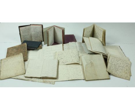
 Manuscript Books Folio Volume. Roll book of Inchanappa School for 1837 to 1841. Names 41 pupils, with comments on absences such as "picking potatoes", "gone to Arklow," "America" etc. Many blank pages. Folio Volume: Church Education Society for Ireland Report Book. Contains the rolls of Inchanappa School. 2 lists of pupils for 1841. Also numbers present and absent, with daily record of Bible passages read, from 15 Feb 1841 to 4 Feb 1843. The rest blank. Account Book of Rev Mr Crofton, 27 Upper Merrion St., Dublin, for 6 Feb 1835 to 25 June 1841. Contains: (1) accounts of goods sold at Inchanappa (mainly potatoes); (2) accounts of goods sold to workmen; (2) detailed accounts of work done by the blacksmith. Two Commonplace Books of the Rev Henry William Crofton, with religious and other notes, one containing many loose papers. Ten Exercise Books of Rev Henry William Crofton, each containing a Sermon. Scrap Book containing Christmas Cards, Sentimental Prints, etc. Some blank pages. Book titled "Norma". Contains expense accounts of the yacht "Norma" which was purchased by Henry M. Crofton of Inchanappa from Sir John Barrington for £525 on 5 March 1869. Continues to 8 Oct 1875. 33 pp, the rest blank. Small Notebook containing Workmen's Accounts, 1902-1903. Folio Volume. "Army Book 127." Blank. Miscellaneous Papers Indenture on Vellum dated 29 Oct 1789: lease of a house in Navan from Robert Ormsby of Grove, Co. Roscommon, to Anne, Elizabeth and Margaret Everard of Navan, spinsters. Four Folders of Accounts, Rev. William Henry Crofton in account with James Hunt, with rentals of lands in Co. Cork (Ballyvodane, Lackabane, Goalane, Knockaroorke, Garranredmond, Cork City, Ballingarry). Marked respectively as closed on 1 Sept 1849, 29 July 1850, 12 July 1851, and 28 Jan. 1853. Fair copy of the marriage settlement of Henry William Crofton of Inchanappa, Clerk, with Frances, daughter of the late Robert Westropp of Tinnekilly, 1852. Brief on behalf of the respondent, 17 Dec 1867, in the case of George Smith and his wife Frances (widow of Rev. Henry William Crofton), versus Henry Morgan Earbery Crofton (eldest son and successor of the Rev. H.W. and Frances Crofton), to determine what lands the petitioner was entitled to after his marriage. Rental of the estate of Henry Morgan Earbery Crofton in counties Monaghan and Cork, 1862. Bills, estimates etc for draining, repairs, building works at Inchanappa on the farm, farm buildings, and house: Guy Price, carpenter, James Sheil, architect, 1820-1821. A large quantity of miscellaneous vouchers, bills, receipts, etc., mid-19th century. Architectural Drawings Most of these are for work done at Inchanappa House c 1820 by the Dublin architect James Sheil (c1795-1840). Although so little is known about his life, Sheil was important in his day: he virtually doubled the size of Killeen Castle, succeeded Francis Johnston as architect for Tullynally, and designed seats for many of the Leinster gentry. "Plan of the window and dressings in front of Library, full size, for the Miss Earberys. Jas Sheil architect." 97 x 67 cm. "Entablature to the full size for the Library Columns. Soffite of the Corona and Modillions to the full size. Base and Capital of Columns full size for the Library. James Sheil Architect." 99 x 67 cm. "Plans for the Stucco Work at Inchanappa. James Sheil Architect." Design for a stucco ceiling rose for the drawing room. Badly torn and crumpled but the drawing and text are intact. "James Sheil. Plan of the additional farm offices at Inchanappa Co. Wicklow for the Miss Earberys. Elevation of the Cow House & c. Elevation of the Cart House and Piggery." 73 x 53 cm. "J. Sheil. Plans of the Additions & c to the House at Inchanappa Co Wicklow for the Miss Earberys. Plan of the Bedchamber Floor. Plan of the Principal Floor. Plan of the Basement Story." 96 x 66 cm. "Elevation of the Principal Floor for the Miss Earberys, Co. Wicklow. J. Sheil." 65 x 54 cm. Ground plan of Inchanappa House, by John McCurdy. 65 x 48 cm. Two copies of the bedroom plan, John McCurdy architect, 10 Leinster St., Dublin. 68 x 50 cm. Coloured plan of part of house, marking the entrance hall, dining room, housekeeper's room, study, etc. Unsigned (by McCurdy?) Manuscript Maps "Maps of part of the lands of Inchinappo … in tenure of Mr Samuel Sempill … Surveyed August 1757 by Jacob Nevill." Scale, 20 perches per inch. 59 x 48 cm. "A Survey of the Demesne and Lands of Inchanappa ….. done for Mrs Earberry, by Jno Longfield, 1806." 10 perches per inch. An attractive large-scale map, marking in colour the woods, lawn, house and gardens, besides other lands, and with a detailed reference section. 95 x 71 / 37 cm. "Map of C. Grumly's, E. Chapman's, Mrs Chapman's and Fitzsimons's Farm. Being part of the late Counsellor Earbery's Estate. Survey'd in February 1819 by J.S. Manning." 48 x 40 cm. Coloured green, yellow and brown. Marks houses. An attractive map, but unfortunately now torn in two and very fragile. 
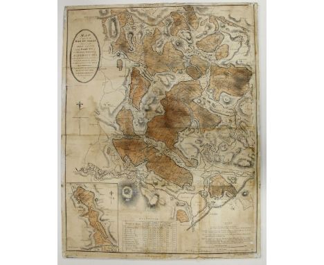
"A Map of the Townlands of Inchinappa North, Inchinappa South and Broomfield; and of portions of the townlands of Ashford and Ballinahinch in the Union of Wicklow, Barony of Newcastle and County of Wicklow. Done for the Rev. H.W. Crofton A.D. 1833." Scale, 10 perches per inch. A fine large-scale coloured map of the Crofton estate. 96 x 67 cm. Printed Maps Ordnance Survey Maps of: · Co. Wicklow, 6", sheet 19, and 1/2500 sheets 19.4 and 25.2 · Co. Cork, 6", sheets 50, 51, 59, 61, 62 · Co. Wicklow index map Map of the South of England showing places marked out for military manoeuvres, 1898. (1)

Lot 347

Signed by Brian O'Nolan & his wife Evelyn [Flann O'Brien] - Theatre Programme for Gaiety Theatre Dublin, for The Insect Play, Signed on Front Cover by 'Brian and Evelyn O'Nolan,' also a programme for Abbey Theatre, Sunday 8th September 1968, - An Evening with Myles, signed by Evelyn O'Nolan; NaGopaleen (Myles) An Béal Bocht, 8vo D. (An Press Náisiunta) 1941, First Edn., First Issue, map end papers, pict. ptd. wrappers. Nice Association Lot. (3)

Lot 36

Co. Waterford: Egan (P.M.) History Guide & Directory of County and City of Waterford, sm. 8vo Kilkenny (P.M. Egan) n.d. c. 1894 Fist Edn., illus. ports. fold. map, adverts etc., orig. cloth rebacked. Good strong copy. (1)

Lot 373

Co. Waterford: Waterford Chamber of Commerce - Burrow's Pointer Guide Map of Waterford, c. 1930, lg. folding map approx. 19 1/2" x 23 1/2", with interesting adverts etc. cold. illus. boards, as a map, w.a.f. V. good. Scarce. (1)

Lot 376

Co. Westmeath: Incumbered Estates - In the Matter of the Estate of the Rev. Peter Toler, Owner & Petitioner. Rental of the Lands of Bolletherlawn; otherwise Clonnydonnin in the Barony of Clonlonan,and also of Houses and Tenements in the Town of Moate, .. in the Co. Westmeath, to Be Sold, ... on Thursday 25th .. June 1857, Lg. folded Atlas folio. Full page hd. cold. map & full hd. cold. plan of property in Moate. V. good. As an Atlas, w.a.f. (1)

Lot 379

The Estates of Richard Reginald Carew Co. Tipperary: In the Matter of the Estate of Richard Reginald Carew, Rental and Particulars of the Lands of Glenegat, .. Lands of Woodenstown or Woodingstown.. Barony of Middlethird, to be Sold .. on Tuesday 3rd May, 1881. Lg. Atlas folio, 1881, 2 lg. fold. maps, plus very large 'Auction Poster for Sale'; together with similar ditto. ... Rental and Particulars of The Castle and Demesne and Parts of the Lands of Woodinstown, containing 377a, 3r, 38p,' to be Sold ... Friday 13th May, 1892. Atlas folio, one lg. full page map, all orig. wrappers. V. good., w.a.f. (3)

Lot 46

[O'Connor (Chas.)] Dissertations on the Ancient History of Ireland:, 8vo D. 1753. First Edn., list of subs, fold. table, & fold. Map of Ireland (torn with some loss), orig. full calf, raised bands, lacks label. (1)

Lot 467

Rare Two Part Irish Map, 1778 Zatta (Antonio) Parte del Regno D'Irlanda cioe Le Provincie d'Ulster e Leinster ... [and] Parte del Regno D'Irlanda cioe La Provincie di Connaught e Munster, Di Nuova Projezione. Venice 1778. Two parts, each approx. 19 1/2" x 15", all hd. cold. in outline, & with fine hand coloured engraved cartouches, framed. In v. fine condition. (2)

Lot 469

Bogs of Ireland: Co. Offaly: Griffith (R.): Log of Part of the Bog of Allen, situated in the King's County, lg. cold. map, 27 ½" x 21", mounted on board. As a Map, w.a.f. (1)

Lot 6

[Taylor (Emily)] The Irish Tourist; or, Tales of the People and the Provinces of Ireland, sm. 8vo, L. (Harvey and Darton) [1843] engd. frontis, fold. map, XII, 271pps & 4pps of adverts., recent mor. backed cloth. Clean copy. (1)

Lot 62

Keating (Jeoffrey) Forus Feasa ais Eirinn - A Complete History of Ireland, From the First Colonization of the Island by Parthalon, to the Anglo-Norman Invasion. Vol. I [All Published] D. (John Barlow) 1811. Fold map frontis (torn with some loss) title stained, text in Gaelic + English thro-out, orig. full cont. tree calf. Scarce. (1)

Lot 88

Sinn Fein, 1916 - Sinn Fein Rebellion Handbook - Easter 1916, roy 8vo D. 1917. Compiled by 'Weekly Irish Times,' this the 1917 Issue (best). Lg. fold. cold. map, portrait illus., fac-simile illus., adverts etc., in orig. printed pink wrappers. An unusually fine copy, mostly found with covers in tatters. V. Scarce thus. (1)

Lot 623

Germany (East) 1950 - leipzig Spring Fair Set on envelope to London (Economy use of red map for envelope) quite scarce

Lot 225

A copy of a John Speede map of The Countye of Monmouth

Lot 61

Mixed framed pictures to include a map of the Parliamentary Representation of Great Marlow and others

Lot 110

WWII RAF/SOE silk escape map of zones of France, 2nd edition, dated March 1944, scale 1:2,000,000, together with further RAF Top Secret map of airfields locations in Normandy and North Western France indicating all airfields and airstrips, also V1 rocket bases in Normandy, dated August 1944, together with further map "Everybody's war map of South Africa" produced by W R Russell & Co Ltd, Paternoster Row, EC London, printed on canvas (3)

Lot 140

An Antique map of Somersetshire, by John Speede, dated 1630, image 32cm x 43cm

Lot 22

British County map, Johannes Blaeu, Darbiensis Comitatus Vernacule Darbieshire, published Amsterdam circa 1648, hand coloured, image 38cm x 50cmVery good condition, no foxing or tears, not stuck down to back board, modern frame and mount also in good condition

Lot 144

Roger Montgomery, 17th century or later, a map of Shropshire, coloured engraving, 38 x 50cm (plate) After Thomas Sanders, views of Shrewsbury, engraving, 23.5 x 41.5cm (I) with a 19th century lithograph of Shrewsbury and a map, 17th century or later of Shropshrire, all a/f, a pair, a/f (9)

Lot 11

A Pan American Clipper Club world map showing flight routes and destinations of Pilot Walter B. Wentz. The map is framed, measuring 79cm in length and 55cm in height.

Lot 258

A collection of small silver etc., to include a coffee grinder, scent bottle lid, mustard pot with hinged lid, a silver coloured metal cigarette case, engraved with a map of India and with a personal inscription to the interior dated 1945, and a small mustard pot with angular handle in the manner of Christopher Dresser, etc.

Lot 382

After Emmanuel Bowen. A map of Lincolnshire divided into its Wapontakes, later coloured, 74cm x 53cm.

Lot 491

A collection of books relating to Norfolk and Suffolk, to include Wry (Norfolk families), Mortlock and Roberts Guide to Norfolk Churches, Suffolk Churches and their Treasure by Cautley (H. Monroe), two volumes, and Kirby (John), The Suffolk Traveller, second edition, with map, various notes by previous owners, later brown leather and marbelled binding, and two volumes of White's 1845 Norfolk, published by David and Charles, reprints.

Lot 614

A Satmap Active 20 GPS map system computer, 12cm high, with outer case and paperwork.

Lot 534

Atkyns (Sir Robert) The Ancient and Present State of Gloucestershire, folio, full calf, illus. with engravings, map and County family armorials, second edition 1768.

Lot 543

Raine (The Rev. James) The History & Antiquities of North Durham, Now United to the County of Northumberland, folio, full morocco, illus. with mezzotint frontispiece, engravings, lithographs and map, published by John Bowyer Nichols & Son, Durham 1852.

Lot 555

G* Valk "La Mer Mediterranee" - a map of the Mediterranean Sea depicting all bordering countries, engraving, with original hand-colouring, c.1700, 48 x 85cms, unframed.

Lot 961

A Nathaniel Hill 2 3/4in. (7cms) pocket globe, English, published 1754, cartouche printed 'A New Terrestrial GLOBE by Nath. Hill 1754', hand-coloured gores with California shown as a peninsula, the Antarctic lacks definition and labelled "Ice Sea", Australia lacking East Coast definition and titled New Holland and North West portion of North America labelled "Unknown Parts", (hairline crack to much of equator), in fishskin case with map of the heavens applied to the inner semi-spheres, 3in. (7.5cm) diameter.

Lot 972

A 19th Century silk work map of England and Wales, marked out to all of the shires and counties with Britannia to top right of oval, within floral and ribbon tied bezel, verre eglomese panel and gold painted frame, 59 x 67cms.

Lot 520

A LOVELY OLD FRAMED MAP OF TORBAY & LIME BAY (3ft 3 X 2ft 3)

Lot 42

A REPRODUCTION MEDIEVAL TYPE MAP OF THE BRITISH ISLES

Lot 652

A RETRO SIX DRAWER MAP STORAGE CHEST, SOLID STRUCTURAL CONDITION WITH COSMETIC WEAR

Loading...Loading...
  • 109182 item(s)
    /page

Recently Viewed Lots