![* Sussex. Saxton (Christopher & Kip William), Sussexia sive Southsex olim pars Regnorum [1637], hand-coloured engraved ma](https://cdn.globalauctionplatform.com/b9199598-926c-41b8-aeda-b0a600f4e350/fa931291-6206-4d9a-b6c0-b0af00c00954/468x382.jpg)

* Sussex. Saxton (Christopher & Kip William), Sussexia sive Southsex olim pars Regnorum [1637], hand-coloured engraved map, re-margined on the vertical borders, some staining, 225 x 390 mm, framed and glazed, together with Norden (John & Hole W.). Hamshire olim pars Belgarum [1637], hand-coloured engraved map, laid on later card, 295 x 320 mm, framed and glazed, with Morden (Robert). Dorset Shire [and] Midlesex [1695 or later], two hand-coloured engraved maps, each approximately 360 x 425 mm, framed and glazed, plus Chapman (John & André Peter). Sheet XIII from their large-scale map of Essex, 1777, engraved map sheet centred on Hatfield, contemporary wash colouring, slight marginal creasing and fraying, 470 x 600 mm, framed and glazed, together with an 18th-century ward plan of the parish of St Martins in the Fields and a 19th-century map of the Orkneys, Shetlands and Hebrides, both framed and glazedQTY: (7)
We found 109198 price guide item(s) matching your search
There are 109198 lots that match your search criteria. Subscribe now to get instant access to the full price guide service.
Click here to subscribe- List
- Grid
-
109198 item(s)/page
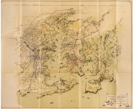
Sydney. Guide to the Port of Sydney N. S. W. published by The Maritime Services Board of N. S. W. printed by D. H. Paisley, Govt. printer, circa 1925, containing five folding maps including Birds Eye View of the Port of Sydney, Sydney Harbour Trust, 1919, colour lithographic pictorial map, printed on thin paper, old folds, short splits where old folds cross, occasional closed tears, 610 x 750 mm, together with Map of the Wharf Accommodation of the Port of Sydney, circa 1920, colour lithographic pictorial map, printed on thin paper, old folds, short splits where old folds cross, torn with the upper left corner of the map detached which remains bound into the volume, with Sydney Harbour Trust, Birds Eye View Showing new Wharfage Scheme Walsh Bay Sydney, circa 1920, colour lithographic pictorial map, printed on thin paper, old folds, short splits where old folds cross, torn with loss, 525 x 810 mm, plus Sydney Harbour Trust Birds-Eye View Showing New Wharfs & Approaches Jones Bay Pyrmont, circa 1920, colour lithographic pictorial map, printed on thin paper, old folds, trimmed to the image along the left hand margin, 470 x 815 mm, and Sydney Harbour Trust Birds-Eye View of Terminal Grain Elevator and Proposed Cargo Berths Glebe Island Port Jackson N. S. W. circa 1920, colour lithographic pictorial map, printed on thin paper, old folds, trimmed to the image along the left hand margin,590 x 815 mm, the volume also contains numerous uncoloured photographic views of the harbour and docks including two folding plates, publisher's green cloth gilt, spine faded, 8vo, together with Paterson (Daniel). Paterson's Twenty-Four Miles round London, with Reference to Seats of the Nobility and Gentry. London, published Bowles and Carver, 25th July 1791, circular engraved map with bright contemporary hand colouring, sectionalised and laid on linen, reference tables to each of the spandrels, very slight spotting, some wear cracks and small holes where old folds cross, crude tape repairs to verso, overall size 660 x 660 mm, contained in a contemporary card slipcase with publisher's printed label to the upper cover and advertisement to the rear cover, worn and frayed with crude tape repairs to the extremities, with Stanford (Edward). A Chart of the World on Mercator's Projection Shewing the Principal Ocean Steam Routes & Submarine Telegraphs &c. Jany. 1st. 1885, large engraved map with contemporary outline colouring, sectionalised and laid on linen, 660 x 1100 mm, contained in a contemporary cloth slipcase with printed title label to the upper cover, plus Hall (Sidney). A Travelling County Atlas..., 1842, printed title, 26 (only) engraved maps with contemporary outline colouring including one folding (Ireland), contents shaken and loose, contemporary 'envelope style' green morocco gilt covers, heavily worn and frayed, with another 10 British and foreign county and regional folding maps, including examples by or after Hughes, Buxey, Ordnance Survey, Bouchard, Allnutt, Vuillemin, Cassell and Colonel Thuillier, various sizes and conditionQTY: (13)NOTE:The Map of London by Paterson. James Howgego. The Printed Maps of London, no.212a. Howgego lists the first edition as 1797. This appears to be an unrecorded state, published six years prior to the first recorded edition.
Teesdale (Henry, publisher). New British Atlas, Containing a Complete set of County Maps, on which are Delineated all the Principal Cross Roads, Cities, Towns & most Considerable Villages, Parks, Rivers, Navigable Canals & Railways, Preceded by General Maps of England, Ireland, Scotland, North & South Wales....., 1829, calligraphic title with contemporary manuscript ownership signature, folding maps of England & Wales, Ireland, and Scotland, 43 (only) engraved maps with contemporary wash colouring, several maps with closed tears, marginal fraying and occasional loss, tears crudely repaired with sellotape, a few maps torn with severe loss, map of Yorkshire with juvenile scribbling, text block detached with contents shaken and loose, contemporary half calf, very heavily worn and frayed, spine crudely repaired with tape, slim folio QTY: (1)NOTE:Sold as a collection of maps, not subject to return.

Thomson (John). A New General Atlas, consisting of a series of geographical designs on various projections, exhibiting the form and component parts of the Globe; and a collection of maps and charts, delineating the natural and political divisions of the empires, kingdoms, and states in the World. Constructed from the best systematic works, and the most authentic voyages and travels. With a memoir of the progress of geography, a summary of physical geography, and a consulting index to facilitate the finding out of places, Edinburgh: Printed by George Ramsay and Company, for John Thomson and Company, Edinburgh; Baldwin, Cradock, and Joy, London; and John Cumming, Dublin, 1817, printed title with some spotting, dedication to Alexander Keith of Dunottar and Ravelston, a 'Memoir of the Progress of Geography', uncoloured engraved double-page comparison plate with two small holes and some marginal closed tears, list of maps and charts, 23 pages of introductory text and 22 pages of a consulting index, several preliminary leaves frayed. torn and detached, 65 (only of 74) double-page and folding maps, all with contemporary outline colouring, some off-setting and slight spotting, some staining throughout, a few maps frayed at the margins, map of the Western hemisphere torn in half, maps of Europe and the British Isles with long closed tear, map of England split in half with frayed margins, Africa with small area of juvenile scribbling, Southern Provinces of the United States split and frayed along old fold, map of Caraccas and Guiana heavily stained and spotted, frayed with slight loss and laid on later stiff paper, hinges broken, contemporary half calf, lacking spine, boards near detached, heavily worn and frayed, folioQTY: (1)NOTE:Lacking the maps of:- The World on Mercator's projection, The North Horizontal Hemisphere, Ireland, Remote British Islands, sheets 3 & 4 the four sheet map of Europe, General Map of Asia, Hindostan, Atlantic Islands and South America. Sold as a collection of maps, not subject to return.
![* Wales. Speed (John), Wales, Thomas Bassett & Richard Chiswell [1676], hand-coloured engraved map, twelve oval vignettes](https://cdn.globalauctionplatform.com/b9199598-926c-41b8-aeda-b0a600f4e350/8507aa45-ca12-4e39-bbb0-b0af00c00bf8/468x382.jpg)
* Wales. Speed (John), Wales, Thomas Bassett & Richard Chiswell [1676], hand-coloured engraved map, twelve oval vignettes of principal cities to the vertical margins and inset views of Bangor, St. Davids, Llandaff and St Asaph, old printer's fold, 385 x 510 mm, mounted, framed and double-glazed, English text on versoQTY: (1)

* Wales. Van den Keere (Pieter), Eight maps of Wales and Welsh counties, comprising of, Wales, Glamorganshire, Pembrokshire (sic), Mounmouthshire (sic), Montgomeri e Merionidh Shires, Radnor Breknok Cardigan and Caermarthen discribed, Anglesey and Carnarvon [and] Denbigh and Flint discribed, circa 1627, together eight uncoloured engraved miniature maps, some maps toned overall, each approximately 85 x 125 mm, uniformly mounted, framed and glazed, together with Luffman (John). Seven maps of Welsh counties, Pembrokeshire, Flintshire, Denbighshire, Caernarvonshire, Cardiganshire, Merionethshire, Anglesea together with Shropshire, circa 1803, together eight circular engraved maps with English text below each map, all with contemporary outline colouring, some toning and slight oxidisation to the old watercolour, each map (including the text) approximately 145 x 75 mm, uniformly mounted, framed and glazedQTY: (16)
![Wiltshire. Speed (John), Wilshire, Thomas Bassett & Richard Chiswell [1676], uncoloured engraved map, inset city plan of](https://cdn.globalauctionplatform.com/b9199598-926c-41b8-aeda-b0a600f4e350/5df6800f-9766-4b1b-aa27-b0af00c00d23/468x382.jpg)
Wiltshire. Speed (John), Wilshire, Thomas Bassett & Richard Chiswell [1676], uncoloured engraved map, inset city plan of Salisbury and an inset vignette of Stonehenge, large margins, slight staining and dust soiling, long repaired closed tear affecting the printed image, 385 x 505 mm, English text on verso, together with Jansson (Jan). A Map of Wiltshire, C. Dicey & Co. circa 1770, uncoloured engraved map, slight creasing and dust soiling, old folds, one repaired marginal closed tear, 395 x 480 mm, no text on verso, with Bowen (Emanuel). An Improved Map of Wilt Shire Divided into its Hundreds, Collected from the best Materials..., Carington Bowles and Robert Sayer, circa 1765, engraved map with contemporary outline colouring, originally published in 'The Large English Atlas', large uncoloured cartouche and dedication, slight dust soiling, short split at the base of the central fold, 540 x 705 mm, plus Greenwood (C. & J.). Map of the County of Wilts, from an Actual Survey..., Greenwood & Co. 1829, engraved map with contemporary wash colouring, calligraphic title, compass rose, table of explanation, reference to the Hundreds and an uncoloured vignette of Salisbury cathedral. slight water staining and offsetting, short split at the base of the central fold, 570 x 685 mm, with another copy similarQTY: (5)
![Worcestershire. Speed (John), Worcestershire Described, John Sudbury & George Humble [1627], hand-coloured engraved map,](https://cdn.globalauctionplatform.com/b9199598-926c-41b8-aeda-b0a600f4e350/8814b8c6-2e76-411e-b408-b0af00c00dac/468x382.jpg)
Worcestershire. Speed (John), Worcestershire Described, John Sudbury & George Humble [1627], hand-coloured engraved map, an inset town plan of Worcester, large strapwork cartouche, mileage scale and compass rose, occasional marginal tears, some repaired, centrefold partially strengthened on verso, one small hole affecting the printed image, 385 x 510 mm, English text on versoQTY: (1)

World. Gill (Macdonald). The "Time and Tide" Map of the Atlantic Charter, George Philip and Son Ltd, 1944, large colour photolithographic map, old folds, several repaired closed splits and tears, some fraying and areas of loss affecting the printed image, slight dust soiling, laid on hardboard, 840 x 1095 mm.QTY: (1)
World. Perouse (Jean Francois Galaup, Comte de la), Mappe Monde ou Carte Reduite des Parties Connues du Globe pour Servir au Voyage de la Perouse, Paris [1797], large hand-coloured engraved map on a hemispheral projection, centred on the Pacific, old folds, 590 x 910 mm, together with Collins (Rear Admiral K. St B. OBE, DSC, Hydrographer). The World, published by the Admiralty, 1966, colour printed map of the world, slight staining to the margins, 680 x 1000 mmQTY: (2)NOTE:The first described item shows the Voyage of Captain La Perouse, a French naval officer and explorer and illustrates his voyages between 1785 - 88. La Perouse and his expeditionary force vanished in Oceania in 1788, his final fate unknown.

World. Wallis (Edward), Wallis's New Game exhibiting a Voyage round the World, circa 1820, engraved map with contemporary wash colouring, sectionalised and laid on linen, the margins decorated with an additional five hemispheres including one title 'Explanation of Geographical Characters, very slight dust soiling, old pin holes to each corner, 400 x 610 mmQTY: (1)
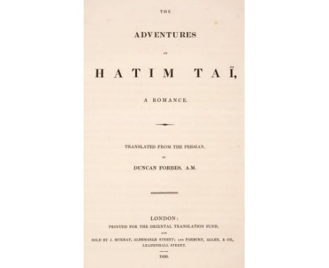
Forbes (Duncan, translator). The Adventures of Hatim Tai, a Romance. Translated from the Persian, 1st edition in English, London: printed for the Oriental Translation Fund, 1830, 214 pp., Oriental Translation Fund presentation leaf at front with the statement 'This copy was printed for Peter Johnston, Esq.. of Carnsalloch, a Subscriber to the Oriental Translation Fund', a little light spotting, hinges reinforced, contemporary calf gilt, rebacked with original spine relaid, a little rubbed with some edge wear and stains, 4to, together with Skinner (H. D.) The Morioris of Chatham Islands. Memoirs of the Bernice P. Bishop Museum Volume IX, Number 1 with Plates I-XXXV, Bayard Dominick Expedition Publication Number 4, Honolulu, Hawaii: published by the Museum, 1923, map in text, monochrome illustrations, light spotting to title, small previous owner stamp, original burgundy buckram, 4to, plus Parker (E. H.) Studies in Chinese Religion, 1st edition, London: Chapman and Hall, 1910, half-tone illustrations, advertisement leaf at front, some light spotting, original cloth gilt, spine a little faded, 8vo, with others including Kwang Tung or Five Years in South China, by John A. Turner, circa 1896, Extreme Oriental Mixture, by Gilbert Collins, 1925, Decorative Art of New Guinea. Incised Designs, by Albert Buell Lewis, Anthropology Design Series No. 4, Field Museum of Natural History Chicago, 1925, Carved and Painted Designs from New Guinea, by Albert Buell Lewis, 1931, and The Junks and Sampans of the Yangtze, Volume I: Introduction and Craft of the Estuary and Shanghai Area, by G. R. G. Worcester, Shanghai, 1947 QTY: (45)

World. Wyeth (Newell Convers 1881 - 1945). Map of Discovery. Eastern & Western Hemispheres, National Geographic Society, 1928, a pair of colour-printed decorative maps of the two world hemispheres, old folds, each approximately 415 x 465 mm QTY: (2)NOTE:The maps were originally commissioned as part of a series of five murals for the Hubbard Memorial Hall (The National Geographic Society's first formal library) in Washington D. C. The set was called The Romance of Discovery and the five murals were also published as frontispieces in the National Geographic Magazine in March, May, July, November and December 1928. The hemispherical maps were the fourth and fifth mural.

Atkinson (Edwin). The Himalayan Districts of the North-Western Provinces of India, 2 volumes, 1st edition, Allahabad: North-Western Provinces and Oudh Government Press, 1882-84, folding geological map of India and two further plates to volume one, one photozincographic plate to volume two, smaller diagrams in text, top right-hand corner of volume one title torn away, two preliminary leaves (including title) in volume two obtrusively reinforced with tape to gutter, a few concomitant worm tracks throughout both volumes (occasionally heavier to some leaves), a few leaves marginally damp-stained, occasional toning, modern utilitarian cloth-backed boards, rubbed and marked, 8voQTY: (2)
![[Kinloch, Charles Walter]. De Zieke Reiziger; or, Rambles in Java and The Straits. In 1852. By a Bengal Civilian, 1st edition](https://cdn.globalauctionplatform.com/b9199598-926c-41b8-aeda-b0a600f4e350/947825f5-8034-42ca-9788-b0af00bfd6b9/468x382.jpg)
[Kinloch, Charles Walter]. De Zieke Reiziger; or, Rambles in Java and The Straits. In 1852. By a Bengal Civilian, 1st edition, London: Simpkin, Marshall and Co., 1853, tinted lithographed additional title, map of Java, 23 lithographed plates (2 coloured, 21 tinted), one plate loose, lightly dust-soiled with a few water spots, original green pictorial blindstamped cloth gilt, rebacked with original spine relaid, 8voQTY: (1)NOTE:Abbey, Travel 556. Includes views of Singapore, Penang and Batavia.
![Bible [English]. The Holy Bible, containing the Old Testament, and the New: Newly Translated out of the Originall Tongues: an](https://cdn.globalauctionplatform.com/b9199598-926c-41b8-aeda-b0a600f4e350/1798ccfb-47ba-40f7-8851-b0af00c0431a/468x382.jpg)
Bible [English]. The Holy Bible, containing the Old Testament, and the New: Newly Translated out of the Originall Tongues: and with the former translations diligently compared and revised..., Imprinted at London by Bonham Norton and John Bill, 1620/21, general title within woodcut border (imprint dated 1620), New Testament also within woodcut border (imprint dated 1621), colophon dated 1621, Apocrypha present, black letter text in double-column, bound with at front Book of Common Prayer, The Booke of Common Prayer, with the Psalter or Psalmes of David, of that translation which is appointed to be used in Churches, Imprinted at London by Bonham Norton and John Bill, 1621, title printed in red and black within decorative woodcut border (border at gutter and gutter margin partly excised and repaired, dust-soiled), collects and Psalms in black letter, bound with [Speed, John], The Genealogies recorded in the sacred Scriptures, according to every familie and tribe. With the line of our Saviour Jesus Christ, observed from Adam to the Blessed Virgin Mary, by J[ohn]. S[peed]., [1620?], containing woodcut genealogies and woodcut illustration of Adam and Eve in the Garden of Eden, double-page woodcut map of the Canaan by Speed present, bound with at rear Concordance, Two Right profitable and fruitfull Concordances, or, large and ample tables alphabeticall..., collected by R. F. H., London: Bonham Norton, and John Bill, 1619/20, title imprint dated 1619 and colophon dated 1620, bound with Book of Psalms, The Whole Booke of Psalmes. Collected into English Meeter, by Thomas Sternehold, John Hopkins, and others, conferred with the Hebrew..., London: Printed for the Company of Stationers, 1621, woodcut device to title surrounded by early marginal notes, incomplete at rear (lacking all after G6), some dust-soiling and toning throughout (mostly light), 3 leaves of 18th-century manuscript notes to blanks at front of volume, front free endpaper near detached, near-contemporary reversed calf, joints split, wear at head and foot of spine and to board corners, 4to (21.5 x 15.5 cm)QTY: (1)NOTE:Herbert 379; Darlow & Moule 292; STC 2262.Both titles omit the words Appointed...; heading on Ppp2 b, II. Coainthians; in Mark xiv. 46, on is omitted. The signature D4 is correctly printed D4 whereas in some examples it is printed C4.

Paoli (Sebastiano). Codice Diplomatico del Sacro Militare Ordine Gerosolimitano oggi di Malta ... illustrato con una serie cronologica de'Gran Maestri, ... con alcune notizie storiche, genealogiche, geografiche, ed altre osservazioni, volume 1 only (of 2), Lucca: Salvatore e Giandomenico Marescandoli, 1733, half-title, title in red and black (with old ink stamps to lower blank margin), folding engraved map, folding table and 8 engraved plates, some worming to blank margins, light toning and occasional spotting, contemporary sheep, gilt decorated spine, worn, folio, together with:Surius (Bernardinus). Den godtvruchtighen pelgrim ofte Jerusalemsche reyse, Antwerp: Hieronymus Verdussen, 1705, engraved title, 8 plates and engraved folding map (short tear to fore-margin of map), illustrations and plan to text, some light damp staining, contents sprung, contemporary calf, gilt decorated spine, torn to upper compartment of spine, 8voQTY: (2)NOTE:The 2nd volume of the first title was published in 1737.
![[Sardar, Jarmani Dass]. Visit of His Royal Highness The Prince of Wales, K. G., M. C. to the capital of the Punjab. February](https://cdn.globalauctionplatform.com/b9199598-926c-41b8-aeda-b0a600f4e350/727cd5ee-51e1-4670-93a6-b0af00bfdc47/468x382.jpg)
[Sardar, Jarmani Dass]. Visit of His Royal Highness The Prince of Wales, K. G., M. C. to the capital of the Punjab. February 25th - 1st March 1922, Lahore: Printed by the Supdt., Govt. printing, Punjab, [1922], folding frontispiece, 10 black and white plates after photographs, folding map at rear, light scattered spotting, original limp black cloth, lightly rubbed, 8voQTY: (1)NOTE:Scarce. We can only trace two copies held institutionally.

Bachiene (Willem Albert). A Biblical atlas containing 11 maps and one plan by Bachiene mostly of the Holy Land during different historical periods, engraved by J. van Jagen, Gorinchem: Nicolaas Goetzee, 1748-50, comprising 11 double-page maps and one double-page plan of Jerusalem, each interleaved with 2 explanatory text leaves in Dutch, occasional light dust-soiling and few marks, edges untrimmed, modern half calf, folio (map sheet dimensions 41 x 52 cm)QTY: (1)NOTE:The Biblical atlas displays a series of 12 engraved maps of the Holy Land during different historic periods. The maps were drawn by Willem Albert Bachiene, a Dutch preacher, astronomer, and geographer. Each double-page map is inserted between pages of explanatory text and has a decorative vignette of an appropriate event and a baroque title cartouche.
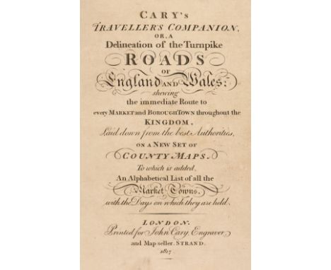
Cary (John). Cary's Traveller's Companion or a Delineation of the Turnpike Roads of England and Wales; shewing the immediate Route to every Market and Borough Town throughout the Kingdom..., 1817, calligraphic title, advertisement and contents leaf, 43 (complete) engraved maps with contemporary outline colouring (complete), including folding map of Yorkshire (Yorkshire with long closed tear), index of market towns bound at rear, bound with Cary's New Itinerary: or an Accurate Delineation of the Great Roads, Both Direct and Cross throughout England and Wales: with many of the Principal Roads in Scotland..., J. Cary, 1817, calligraphic title and dedication, folding engraved map of England and Wales with long closed tear, six engraved folding regional maps with contemporary outline colouring, further tables and indices, endpapers with later pencil annotations and notes, contemporary 'envelope style' black morocco binding, 8vo, together with Cary's New Map of England and Wales with part of Scotland. with Part of Scotland, on which are carefully laid down all the Direct and Principal Cross Roads, the Course of the Rivers and the Navigable Canals, Cities, Market and Borough Towns, Parishes and most considerable Hamlets, Parks, Forests &c &c, 1st edition, June 11th 1794, title and dedication, general map of England & Wales and table of explanation, and 76 (complete) engraved map sheets (numbered 1 - 81 and omitting 62/63, 71/72 & 80 as intended), all with contemporary outline colouring, index bound at rear, some offsetting, text block cracked and partially split, contemporary sheep in an 'envelope style' heavily worn and frayed, 4to, with Fordham (Sir Herbert George). John Cary. Engraver, Map, Chart, Print-Seller and Globe Maker 1754 to 1835, Wm. Dawson & Sons Ltd, 1976, additional half-title, publisher's gilt cloth, 8vo, plus Barber (Peter, editor). The Map Book, Weidenfeld & Nicholson, 2005, additional decorative half-title, numerous colour plates throughout, publisher's gilt cloth, dust jacket torn with slight loss to the spine, folioQTY: (4)
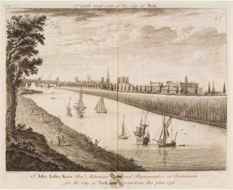
Drake (Francis). Eboracum: or the History and Antiquities of the City of York ..., London: Printed by William Bower for the author, 1736, 60 engraved plates, plans and maps (few folding, one folding map and 2 folding plates trimmed and lined to verso), engraved illustrations to letterpress, without portrait frontispiece (not called for in plate list), some repaired closed tears and marginal tears to few leaves text and plates, all edges gilt, contemporary diced calf, rebacked, board corners worn and showing, folio, together with:Langdale (Thomas). A Topographical Dictionary of Yorkshire..., 2nd edition, Northallerton: J. Langdale, 1822, hand-coloured folding engraved map frontispiece, 2 folding tables, contemporary calf, morocco title label, light wear to to extremities, 4to,Bawdwen (William). Dom Boc. A translation of the Record called Domesday, so far as relates to the County of York..., with an introduction, glossary, & indexes, Doncaster: Printed by W. Sheardown, 1809, upper margin of title with signature John Lee, some browning mostly to first and last leaves, endpapers renewed with armorial bookplates of Heytesbury House and Chapman-Purchas to upper pastedown retained, near-contemporary straight-grain light brown morocco, gilt decorated spine and roll decoration to boards, 4to, plus other 19th and early 20th-century Yorkshire topography related, including guides, tours etc.QTY: (16)

Tolkien (J. R. R.). The Lord of The Rings, 3 volumes, London: George Allen & Unwin, 1965, 14th impression of Fellowship of the Ring, 11th impression of the other two, folding map to each, original backstrips bound-in at rear, all edges gilt, modern red crushed morocco gilt, spines lightly faded, 8voQTY: (3)
Ball (John). The Modern Practice of Physic: or, a method of judiciously treating the several disorders incident to the human body, 2 volumes, 2nd edition, London: A. Millar, 1762, occasional ink stamps, sewing partly broken in volume 1 and contents shaken, later endpapers, contemporary calf, crudely rebacked and corners repaired, 8vo, together with:Buchan (William). Domestic Medicine; or, a treatise on the prevention and cure of diseases..., London: W. Lewis, 1822, contemporary calf, joints cracked, 8vo, Veitch (James Herbert). A Traveller's Notes or Notes of a Tour through India, Malaysia, Japan, Corea, the Australian Colonies and New Zealand during the years 1891-1893, 1st edition, Chelsea: James Veitch & Sons, Royal Exotic Nursery (for private circulation only), 1896, folding colour lithograph map, 9 photogravure plates with tissue guards, illustrations to text, original pictorial cloth, rubbed, spine browned and a little worn at ends, 4to, Spencer (Herbert). The Principles of Psychology, London: Longman, Brown, Green, and Longmans, 1855, contemporary half morocco, gilt decorated spine, joints split, 8vo,Miles (Henry Downes). Pugilistica: Being one hundred and forty-four years of the history of British Boxing, 3 volumes, London: Weldon & Co., [1880-81], wood engraved frontispieces, plates and illustrations, original brown cloth, blocked in gilt and black, extremities rubbed, 8vo, plus other antiquarian and 20th-century miscellaneous, including French language works by the poet Charles Péguy etc.QTY: (3 cartons)

Harrison (John). Maps of the English Counties with the Sub Divisions of Hundreds, Wapontakes, Lathes, Wards, Divisions &c. to which are added two folio pages of Letter-press to face each map..., London: printed by and for John Harrison, 1791, title page creased and dust-soiled with crude near contemporary ownership signature, and, several tears repaired with tissue, eight pages of index tables, 38 (complete) engraved maps with contemporary outline colouring, each map with a page of descriptive text, waterstained throughout, later endpapers, hinges strengthened, contemporary marbled boards, re-backed with a 20th-century morocco spine with a contrasting morocco gilt label, bumped and worn, oblong folio, QTY: (1)NOTE:Chubb, CCXCI.

Barrett (C. R. B.). The 7th (Queen's Own) Hussars, 2 volumes, London: Spottiswoode & Co., 1914, colour frontispieces plus monochrome illustrations & maps, some minor marginal toning plus spotting to the text-block, original uniform gilt decorated black half morocco, 4to, together with:Lawrence (T. E.), Severn Pillars of Wisdom, 1st trade edition, London: Jonathan Cape, 1935, original cloth in dust jacket, covers light marked with a crease to the spine, 4toRevolt in the Desert, 1st edition, 1927, folding map to the rear, original cloth in dust jacket, covers very lightly marked, 8voThe Mint,...,1st edition, 1955, original cloth in dust jacket, covers lightly marked, small tear to the head of the front cover, 4to, and 3 volumes of related T. E. Lawrence reference, plusH.M.S.O., publisher, Collected Reports on British High Speed Aircraft for the 1927 Schneider Trophy Contest [Aeronautical Research Committee reports and memoranda No. 1300], London: January 1931, monochrome illustrations, some light toning, original cloth slightly, rubbed & marked, 8vo, andReide (Thomas Dickson), A View of the Diseases of the Army in Great Britain, America, The West Indies, and on Board of King's Ships and Transports…, 1st edition, London: J. Johnson, 1793, erratum leaf at rear, first and last leaves dampstained, uncut, author’s presentation inscription to ‘Lieut. Col. Mercer, Royal Regt of Engineers’ to front flyleaf, original boards, soiled and worn, 8vo, plus other early to mid 20th century military reference & related, mostly original cloth in dust jackets, some slim political pamphlets, 8vo/4to QTY: (3 shelves )

Langley (Edward). Langley's New County Atlas of England and Wales, Embellished with a Beautiful Vignette to each Map..., 1st edition, Langley & Belch, 1818, engraved calligraphic title, general map of England & Wales with index list below the map and 52 (complete as list) engraved maps with contemporary wash colouring, some marginal dust and finger soiling, some water staining, more pronounced on the last fifteen maps, large juvenile ownership name and address to the front pastedown, executed in red crayon, contemporary half morocco, upper board detached, lacking spine, oblong 4toQTY: (1)NOTE:Chubb CCCLIX. A scarce county atlas.

Morrison (John). The Perillous and most Unhappy Voyages of John Struys, through Italy, Greece, Lifeland, Moscovia,..., 1st English edition, London: printed by Samuel Smith, engraved folding map to the front endpaper, engraved frontispiece, lacking 19 plates, frontispiece & A3 repaired to the edges, marginal toning & light spotting throughout, modern calf spine retaining contemporary full calf boards, 4to, together with:G. G. J. and J. Robinson, printed for, The Philosophical Dictionary: or, the opinions of modern philosophers on metaphysical, moral, and political subjects, 4 volumes, some light marks & toning, original uniform blue & white paper bindings with ink titles to the spines, volume 3 lacking spine, volumes 1, 2, & 4 spines rubbed with loss, contained in a modern clamshell book box, 8vo, plusPye (Henry James), The Sportsman's Dictionary;..., 5th edition, London: printed for John Stockdale, 1807, 17 etched plates, bookplate to the front pastedown, some light toning & spotting throughout, contemporary, gilt decorated half calf, boards & spine slightly rubbed with some loss to the spine, large 4to, and other 16th to 19th century reference & literature, including A Pedegree of the Milborne Family, 1475, a hand written document contained in a green full morocco drop leaf box bound by Riviere & Son, spine lightly faded, mostly leather bindings, some odd volumes, overall condition is generally good, 8vo/4toQTY: (3 shelves )

Robertson (George). Topographical Description of Ayrshire; more particularly of Cunninghame:..., Irvine: Cunninghame Press, 1820, colour folding map frontispiece, some monochrome in-text illustrations, bookplate to the front pastedown, later endpapers, period inscription to the head of the title page, water stains from the title page through to pp.100, contemporary gilt decorated full calf, boards & spine slightly rubbed with some minor loss, large 4to, together with:Willis (R.), The Architectural History of Chichester Cathedral,..., Chichester: William Hayley Mason, 1861, hand coloured & monochrome plates plus illustrations, 'Bishop of Chichester' bookplate to the front pastedown, some light toning & spotting, contemporary gilt decorated blue half morocco, boards & spine slightly rubbed to head & foot, large 4to, plus other early 20th century & modern British topography & genealogy reference & related, mostly original cloth, some in dust jackets, some paperback editions, G/VG, 8vo/4toQTY: (6 shelves )

Mackenzie (Eneas). An Historical, Topographical and Descriptive View of the County of Northumberland, and of those parts of the county of Durham situated north of the river Tyne..., 2 volumes, 2nd edition, carefully corrected and greatly enlarged, Newcastle: Mackenzie and Dent, 1825, 17 engraved plates including frontispieces, folding engraved county map, light toning and minor scattered spotting, bookplate of Ravensworth Castle to upper pastedowns, contemporary half morocco gilt, 4to, together with:Mackenzie (Eneas). A Descriptive and Historical Account of the Town and County of Newcastle upon Tyne, including the Borough of Gateshead, 2 volumes in one, Newcastle upon Tyne: Mackenzie and Dent, 1827, 16 engraved plates including frontispieces, some toning, spotting, dust-soiling and marks, contemporary reversed calf, morocco title label to spine, upper joint cracked and some wear to extremities, 4to,Lysons (Daniel). The Environs of London..., 2 volumes in four, 2nd edition, London: T. Cadell and W. Davies, 1811, 2 additional engraved titles, plates, maps and plans (few folding), with An Historical Account of those Parishes in the county of Middlesex, which are not described in the Environs of London, London: T. Cadell Jun. and W. Davies, 1800, engraved title, plates, plans and maps (few folding), contemporary uniform maroon morocco-backed cloth, extremities rubbed, large 4to, Lysons (Samuel). A Collection of Gloucestershire Antiquities, London: T. Cadell and W. Davies, 1804, engraved title, 110 engraved and etched plates including some hand-coloured, some damp stains and occasional spotting mostly to margins, closed tear to front free endpaper, contemporary maroon morocco-backed cloth, folio,Bird (Charles). Picturesque Old Bristol. A Series of Fifty-Two Etchings ... with Letterpress by John Taylor, 2 volumes, Bristol: Frost and Reed, 1885, 53 etched sepia plates (including frontispiece), tissue-guards, volume 2 with half-title, index leaf and publisher's notice, offsetting to tissue-guards, occasional spotting, contemporary half morocco gilt, joints & extremities rubbed and slightly worn, large 4to, Wells (Samuel). The History of the Drainage of the Great Level of the Fens, called Bedford Level; with the Constitution and Laws of the Bedford Level Corporation, 2 volumes, London: Published for the Author, by R. Pheney, 1830, some scattered spotting, original cloth-backed boards, some wear, 8vo, plus one otherQTY: (14)

Justamond (J.). A Philosophical and Political History of the Settlements and Trade of the Europeans in the East and West Indies, 5 volumes, 2nd edition, London: printed for T. Cadell, 1776, 3 folding maps [of 4, lacks map in volume 3], engraved portrait frontispiece to volume 1, some light marginal toning & spotting, modern calf spines retaining contemporary mottled full calf boards, lightly rubbed to head & foot, 8vo, together with:Burnet (Gilbert), The History of the Reformation of the Church of England, 3 volumes [volumes 1 & 2 plus the supplement volume], 2nd edition, London: printed by T. H. For Richard Chiswell, 168-1715, engraved title pages to volumes 1 & 2, engraved portrait plates, bookplates to the front pastedowns, some toning & light wear, gutters cracked, contemporary uniform full calf with red morocco spine labels, boards & spine lightly rubbed, folio, plus other mostly 18th & 19th-century history & politics reference, mostly contemporary leather bindings, overall condition is generally good, 8vo/folioQTY: (3 shelves )NOTE:32 volumes from the library of the late Professor Malcom Deas, Oxford University

Nansen (Fridtjof). "Farthest North"..., 2 volumes, London: George Newnes, 1898, colour plates & monochrome illustrations, folding map to the rear of volume 1 torn & repaired, volume 1 front gutter reinforced with white tape, period inscription to the front endpapers of volume 2, some light spotting & toning, original uniform gilt decorated green cloth, boards & spine slightly rubbed, 8vo, together with:Coillard (François), On the Threshold of Central Africa, a record of twenty years' pioneering among the Barotsi of the Upper Zambesi, London: Hodder and Stoughton, 1897, 44 monochrome illustrations, some marginal spotting & toning, original gilt decorated brown cloth, boards & spine lightly rubbed, 8vo, plusHyatt (Stanley Portal), The Northward Trek, London: Andrew Melrose, 1909, 14 monochrome illustrations & 3 maps, front gutter cracked, some light spotting & toning, top edge gilt, original blue cloth, boards & spine lightly rubbed & marked, 8vo, and other late 19th & early 20th-century travel reference & related, some leather bindings, mostly original cloth, G/VG, 8vo/folioQTY: (3 shelves)
Helps (Arthur). The Spanish Conquest in America, and its relation to the history of slavery and to the government of colonies, 4 volumes, 1st edition, London: John W. Parker and Son, 1855, numerous monochrome maps, period inscription to the front endpaper of volume 1, some gutters slightly cracked, some light spotting & toning throughout, original uniform green cloth, some minor rubbing to the head & foot of the boards & spines, 8vo, together with:Bradford (Alexander W.), American Antiquities and Researches into the Origin and History of the Red Race, 1st edition, New York: Dayton and Saxton, 1841, signed & inscribed by the author to the front endpaper, some light marginal toning throughout, original embossed green cloth, boards & spine slightly faded & rubbed to head & foot, 8vo, plusGerrare (Wirt), Greater Russia, the Continental Empire of the World, 1st edition, London: William Heinemann, numerous monochrome illustrations plus a map, front & rear gutters cracked, some light marginal toning, top edge gilt, original gilt decorated red cloth, boards & spine slightly rubbed to head & foot, 8vo, and other 19th & early 20th century travel & history reference, including The Ancient Ruins of Rhodesia, by R. N. Hall & W. G. Neal, 1st edition, London: Methuen & Co., 1902, ex-library copy with associated stamps, original gilt decorated blue cloth, 8vo, some leather bindings, mostly original cloth, some in dust jackets, G/VG, 8vo/4toQTY: (3 shelves)
Morant (Philip). The History and Antiquities of the County of Essex..., 2 volumes, 1st edition, London: T. Osborne, J. Whiston, S. Baker, L. Davies, C. Reymers and B. White, 1768, folding engraved map frontispiece to first volume, 23 engraved plates (including 6 folding, of which 2 linen backed), 11 folding maps and plans (one map linen backed), plus 5 additional plates (each trimmed and mounted), dedication leaf to second volume lined to verso, occasional light toning and spotting, top edge gilt, remainder untrimmed, modern brown half calf, spines slightly faded, folio, together with:Wright (Thomas). The History and Topography of the County of Essex, 2 volumes, London: George Virtue, 1836, additional engraved titles on India paper, engraved map, and 99 plates, some browning, damp staining and spotting mostly to text leaves, top edge gilt, contemporary green half morocco gilt decorated spines, large 4to, plus Barrett (Charles Raymond Booth). Essex: Highways, Byways and Waterways, 2nd series, London: Lawrence & Bullen, 1893, engraved frontispiece, plates and illustrations, original cloth, toned, joints and head and foot of spine frayed and worn, 4to (limited edition 65/125 on fine paper)QTY: (5)
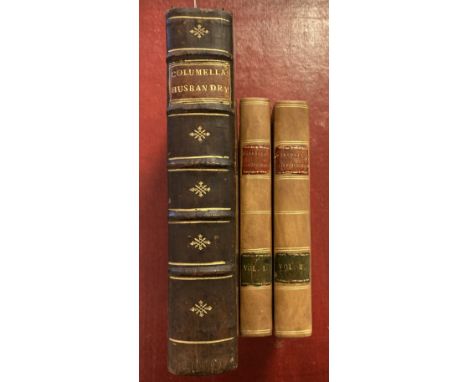
Columella (Lucius Junius Moderatus). Of Husbandry in Twelve Books: And his Book Concerning Trees, Translated into English, with several Illustrations from Pliny, Cato, Varro, Palladius, and other antient and modern Authors, 1st English edition, London: A. Millar, 1745, armorial bookplate of Rt. Hon. Alexander Lord Bamff to upper pastedown, contemporary calf, gilt decorated spine with morocco title label, 4to, together with:Marshall (William). The Rural Economy of Glocestershire; including its Dairy: together with the Dairy Management of North Wiltshire; and the Management of Orchards and Fruit Liquor, in Herefordshire, 2 volumes, 1st edition, Glocester: Printed by R. Raikes, for G. Nicol, Pall Mall, London, 1789, folding engraved map, two publisher's advert leaves at rear of first volume, some damp staining to both volumes, contemporary marbled boards with vellum corners, modern calf rebacks retaining contrasting morocco labels, 8voQTY: (3)NOTE:1. British Bee Books 98. Columella ‘gave very detailed and well-conceived advice on many aspects of apiary management, including requeening, uniting, and migratory beekeeping’.2. ESTC T94236; Goldsmith's 13809.
Conybeare (William Daniel & William Phillips). Outlines of the Geology of England and Wales, with an introductory compendium of the general principles of that science, and comparative views of the structure of foreign countries, part I [all published], 1822, folding hand-coloured map, linen-backed colour folding section, lacking one plate, bound without advertisement plate of instruments, a little light soiling, later half calf, spine a little faded, together with: Lyell (Charles). Elements of Geology or the Ancient Changes of the Earth and its Inhabitants as illustrated by Geological Monuments, by Sir Charles Lyell, 6th edition, 1865, illustrations, a few spots, front hinge broken, original cloth gilt, tear at head of lower joint, 8vo,Wood (Searles). A Monograph of the Crag Mollusca, or, Descriptions of Shells from the middle and upper tertiaries of the east of England, 2 parts, London: Palaeontographical Society, 1848-50, numerous engraved plates, occasional damp staining mostly to margins, original cloth-backed boards, printed paper labels to spines lifting, 4to, Morris (John and Lycett, John). A Monograph of the Mollusca from the Great Oolite, chiefly from Minchinhampton and the coast of Yorkshire, 2 parts in one, London: Palaeontographical Society, 1850-53, numerous lithograph plates, some damp cockling, original cloth-backed boards, worn, 4to, with others related including Charles Lyell's The Student's Elements of Geology, 1871 and a facsimile reprint of James Hutton's Theory of the Earth, 2 volumes, 1972QTY: (21)
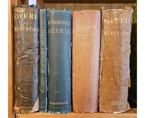
Murchison (Roderick Impey). Siluria. The History of the Oldest known Rocks containing Organic Remains, with a Brief Sketch of the Distribution of Gold over the Earth, 1st edition, London: John Murray, 1854, hand-coloured folding engraved map and folding uncoloured lithograph map, 37 lithograph plates (three folding), wood engraved illustrations, some scattered spotting, front free endpaper creased, original cloth gilt, spine worn with loss and brown with adhesive residue, 8vo, together with three other editions of the same work, comprising 3rd edition, 1859, in original cloth, worn, 4th edition, 1867, 20th-century cloth and 5th edition, 2 volumes (text & plates), 1872, original cloth, all 8vo, together with:Hunter (Joseph). Hallamshire. The History and Topography of the Parish of Sheffield in the County of York, new and enlarged edition by the Rev. Alfred Gatty, London: Virtue and Company, 1875, engraved frontispiece and 12 engraved plates, occasional light spotting, bookplate of William Clarke Vincent to upper pastedown, top edge gilt, remainder untrimmed, contemporary half morocco, joints cracked, rubbed, folioQTY: (6)

Africa. Blaeu (Willem Janszoon), Africae nova descriptio. auct: Guiljelmo Blaeuw. Amsterdam, circa 1650, uncoloured engraved carte-a-figure map, ten costumed figures to the vertical margins and nine oval vignettes of principal cities along the upper margin, large margins, slight overall toning, 410 x 550 mm, Latin text on versoQTY: (1)NOTE:R. V. Tooley. Collector's Guide to the Maps of the African Continent and Southern Africa, page 29, plate 18. One of the most decorative and popular of all the early maps of Africa.

Africa. Laurie (Robert & Whittle James), Africa, with All Its States, Kingdoms, Republics, Regions, Islands, & ca. Improved and inlarged from D'Anville's map, to which have been added the Discoveries of Parke, Vaillant, Brown &c. Also a Particular Chart of the Gold Coast wherein are distinguished all the European Forts and Factories..., 12th May 1800, large engraved map, printed on 4 sheets, conjoined to form a two-sheet map, contemporary outline colouring, inset maps of the Azores and the Gold Coast, old folds, slight browning along one fold, each sheet approximately 530 x 1220 mmQTY: (1)

Africa. Speed (John), Africae described, the manner of their Habits and Buildings newly done into English, Thomas Bassett & Richard Chiswell [1676], hand coloured 'carte-a-figure' map engraved by Abraham Goos, with ten costumed figures to the vertical margins and eight oval vignettes of principal cities along the upper horizontal margin, slight mount staining, upper corners strengthened on verso, slight creasing, 400 x 515 mm, English text on versoQTY: (1)
![Americas. Munster (Sebastian), Americae Sive Novi Orbis Nova Descriptio, Basle, [1588-1628], uncoloured woodblock map of Nort](https://cdn.globalauctionplatform.com/b9199598-926c-41b8-aeda-b0a600f4e350/89fd678b-3302-49d9-bf2b-b0af00bfeff4/468x382.jpg)
Americas. Munster (Sebastian), Americae Sive Novi Orbis Nova Descriptio, Basle, [1588-1628], uncoloured woodblock map of North and South America, toned overall with some spotting, some creasing, 320 x 360 mm, German text on versoQTY: (1)NOTE:Philip Burden, The Mapping of North America, number 67.
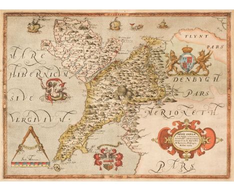
Anglesey & Caernarvon. Saxton (Christopher), Mone Insulae modo Anglesey et Caernarvans duorum borialis Cambriae comitatuum olim vene do cia L. Gwynedhia B. North Wales A, descriptio, Ano Dni 1578 [1579], hand-coloured engraved map, strapwork cartouche with the royal coat of arms of Elizabeth I and those of Thomas Seckford, the sea decorated with sailing ships, sea monsters and an amorous Neptune in an embrace with Salacia, large margins, slight dust soiling and staining to the margins but not affecting the printed image, slight mount staining, near-contemporary manuscript annotation to the right-hand margin and manuscript title to verso, 355 x 485 mmQTY: (1)NOTE:The first printed map of Anglesey and Caernarvonshire, with the bunch of grapes watermark.
![Berkshire. Speed (John), Barkshire Described, John Sudbury & George Humble [1627], hand-coloured engraved map, the upper](https://cdn.globalauctionplatform.com/b9199598-926c-41b8-aeda-b0a600f4e350/bcfcb981-2996-47e9-ae16-b0af00bff217/468x382.jpg)
Berkshire. Speed (John), Barkshire Described, John Sudbury & George Humble [1627], hand-coloured engraved map, the upper margin decorated with a panorama of Windsor Castle, some water staining, small holes to the central fold, short split at the base of the central fold, partial adhesion of old backing paper to verso, 380 x 505 mm, English text on verso, together with Blaeu (Johannes). Rutlandia Comitatus Rutland Shire, Amsterdam circa 1645, engraved map with contemporary hand colouring, large decorative cartouche and mileage scale, 380 x 500 mm, French text on verso, with Jansson (Jan). Scotia Regnum, Amsterdam, circa 1650, engraved map with contemporary hand colouring, inset map of the Orkney Islands, slight spotting and staining, some creasing, closed marginal tear crudely repaired on verso and recto, some abrasion to the central fold, 380 x 500 mm, French text on verso, plus Wyld (James). The Crimea, September 26th 1854, lithograph with contemporary outline colouring, inset maps of the Town & Harbour of Sevastopol and of the Black Sea, several marginal closed tears, 485 x 680 mm, and another 36 British and foreign maps, including examples by or after Morden, Archer and Blackie & Son, various sizes and condition QTY: (40)
![British Isles. Gastaldi (Giacomo), Tabula Europae I, [1548], uncoloured engraved Ptolemaic map with decorative vignettes to v](https://cdn.globalauctionplatform.com/b9199598-926c-41b8-aeda-b0a600f4e350/bbbeb242-94b7-40f6-942c-b0af00bff340/468x382.jpg)
British Isles. Gastaldi (Giacomo), Tabula Europae I, [1548], uncoloured engraved Ptolemaic map with decorative vignettes to vertical margins, some staining, largely confined to margins, 130 x 170 mm, Italian text on verso, together with Magini (Giovanni). Tabula Europae Prima, Cologne [1597], uncoloured engraved Ptolemaic map, slight text show through, some marginal staining, 135 x 180 mm, Latin text on verso, with Porcacchi (Tomaso), Inghilterra, Padua, [1572 - 1713], uncoloured engraved map orientated to the west, Italian text below and on verso of map, map size 105 x 145 mm, plus Munster (Sebastian). Des Isles de Bretaigne..., [1550 - 1568], uncoloured woodcut map set within French text, map size 85 x 140 mmQTY: (4)NOTE:R.W.Shirley. Early Printed Maps of the British Isles 1477 - 1650, numbers 47, 196, 98 and 51/83d.

British Isles. Munster (Sebastian), Engellandt mit dem anstossenden Reich Schottlandt so vor zeiten Albion und Britannia haben geheissen, Basel: Sebastian Petri [1588 - 1628], hand-coloured woodblock map orientated to the west, slight mount staining, toned overall, 320 x 360 mm, German text on verso, together with Mercator (Gerard). Tab. I. Europae Continens Albion, Britanniam et Hiberniam..., Cologne: 1578 - 1730, uncoloured engraved map of the British Isles on a Ptolemaic projection, short split at the base of the central fold, repaired closed tears to the lower right and upper left corners, but not affecting the printed image, 340 x 405 mmQTY: (2)NOTE:R. W. Shirley. Early Printed Maps of the British Isles, numbers 148/407 and 123.

British Isles. Phillips, (John), Geological Map of the British Isles, and Adjacent Coast of France 1862, Society for Promoting Christian Knowlege, engraved map with contemporary wash colouring, sectionalised and laid on linen, inset map of the Shetland Islands, key plan, cross-section and strata, one small hole to the Irish sea, slight dust soiling, 820 x 645 mm, publishers advertisements to endpapers and front pastedown, ink ownership stamp to verso and front pastedown, publishers blind stamped cloth with gilt title to upper siding, upper board detached, faded and wornQTY: (1)
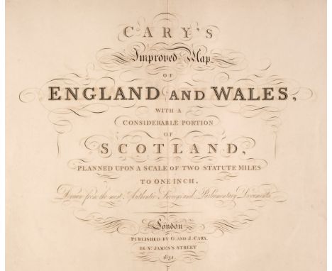
Cary (G. & J.). Cary's Improved Map of England and Wales with a considerable portion of Scotland, planned upon a scale of two statute miles to one inch, Drawn from the most Authentic Surveys and Parliamentary Documents, 1832, calligraphic double-page title, index map, 65 (complete as keymap) engraved double-page map sheets, all with contemporary outline colouring, some offsetting and slight spotting throughout, contemporary half morocco, re-backed but retaining original spine, bumped, frayed and worn, folio, binding size 575 x 390 mmQTY: (1)

Celestial Maps. Zatta (Antonio), Planisferio Celeste Settentrionale Taagliato sull: Equatore & Planisferio Celeste Meridionale Tagliato sull: Equatore, Venice, 1777, a pair of hand-coloured engraved maps, each circular map decorated with vignettes of observatories, central folds strengthened on verso, each approximately 325 x 415 mm QTY: (2)
![De Vaugondy (Robert). Carte des Grandes Routes D'Angleterre, D'Ecosse et D'Irlande [1757 - 68], engraved map with contemporar](https://cdn.globalauctionplatform.com/b9199598-926c-41b8-aeda-b0a600f4e350/5259ad0f-468b-4833-a325-b0af00bff758/468x382.jpg)
De Vaugondy (Robert). Carte des Grandes Routes D'Angleterre, D'Ecosse et D'Irlande [1757 - 68], engraved map with contemporary hand-colouring, large pastoral cartouche, 490 x 590 mm, together with Delamarche (Charles Francois & De Vaugony Robert). Carte des Isles Britanniques qui renserment les Royaumes D'Angleterre, D'Ecosse & D'Irland Divisée par provinces et Comtés, Paris 1804, engraved map with contemporary outline colouring, inset map of the Shetland & Orkney Islands, 540 x 720 mm, with another slightly later example published by Jean Baptiste Fortin, plus Delahaye (Guillaume). Britannicae Insulae in quibus Albion, seu Britannia Major, et Ivernia seu Britannia Minor..., à Nicolas Sanson..., published by Robert de Vaugondy 1705 [but 1757 edition], hand-coloured engraved map, decorative cartouche, 495 x 545 mm, with another copy with contemporary outline colouring, with Sanson (Nicolas), Carte Generale des Royaume D'Angleterre, Escosse et Irlande avecq les Isles Circonvoysines Conues toutes sous le nom de Britanniques..., published Paris, Pierre Mariette, circa 1650, engraved map with contemporary outline colouring, inset map of the Isles of Shetland, 405 x 535 mm, plus Sanson (N.). Britannicae Insula in quibus Albium sive Britannia Major Ivernia sive Britannia Minor..., published Amsterdam, J. Covens & C. Mortier, [1721], uncoloured engraved map, old folds, 410 x 525 mm, and Mariette (Pierre & Sanson Nicolas). Les Isles Britannicques ou sont Le Royaume D'Angleterre..., Paris, 1665, engraved map with contemporary outline colouring, inset map of the Shetland and Faroe Islands, 415 x 525 mmQTY: (8)
![* Denbigh Shire. Speed (John), Denbigh Shire, Thomas Bassett & Richard Chiswell [1676], hand-coloured engraved map, inset](https://cdn.globalauctionplatform.com/b9199598-926c-41b8-aeda-b0a600f4e350/2f1015b7-8b95-4c64-83e4-b0af00bff7e2/468x382.jpg)
* Denbigh Shire. Speed (John), Denbigh Shire, Thomas Bassett & Richard Chiswell [1676], hand-coloured engraved map, inset town plan of Denbigh, slight overall toning, 380 x 505 mm, mounted, framed and glazed, together with Breknoke both Shyre and Towne described, Thomas Bassett & Richard Chiswell [1676], hand-coloured engraved map, inset town plan of Brecknock, slight overall toning, very slight fraying to the central fold, 385 x 510 mm, framed and glazedQTY: (2)
![Derbyshire. Speed (John), Anno Darbieshire described, Thomas Bassett & Richard Chiswell [1676], hand-coloured engraved ma](https://cdn.globalauctionplatform.com/b9199598-926c-41b8-aeda-b0a600f4e350/021dc8e6-de59-4663-8f19-b0af00bff864/468x382.jpg)
Derbyshire. Speed (John), Anno Darbieshire described, Thomas Bassett & Richard Chiswell [1676], hand-coloured engraved map, inset city plan of Derby and a vignette of St. Anne's Well at Buxton, large strapwork cartouche and compass rose, two small holes in the lower margin, but not affecting the printed image, 385 x 510 mm, English text on verso, together with, Suffolke described and divided into Hundreds, the situation of the fayre towne Ipswich shewed, with the Armes of the most noble families that have bene either Dukes or Earles both of that Countie as also of Clare, George Humble, circa 1614, uncoloured engraved map, inset town plan of Ipswich, occasional marginal closed tears and short split to the base of the central fold, crudely repaired, four worm holes affecting the printed image, occasional marginal repaired closed tears, toned overall, 375 x 505 mm, English text on verso, with Bickham (George). A Map of Wiltshire West from London Inscrib'd to the Earl of Pembroke..., 1750, hand-coloured engraved 'birds-eye' map, 260 x 155 mm, together with A Map of Buckinghamshire North West from London Humbly inscribed to his Grace ye Duke of Marlborough..., circa 1750, uncoloured engraved 'birds-eye' map, some water staining to the upper margin, 260 x 155 mm, plus Bowen (Emanuel). An Accurate Map of the County of Kent Divided into its Hundreds..., Carington Bowles, J. Ryall, T. Kitchin, H. Overton, J. Bowles & H. Parker, circa 1762, engraved map with contemporary outline colouring, originally published in 'The Royal English Atlas', splits to the head and foot of the central fold, partially repaired on verso, 410 x 500 mm, and Blaeu (Johannes). Wiltonia sive Comitatus Wiltoniensis Anglis Wil Shire, Amsterdam, circa 1655, uncoloured engraved map, 410 x 495 mm, no text on verso, together with Blome (Richard). A Mapp of Stafford Shire with its Hundreds, Thos. Taylor, circa 1715, hand-coloured engraved map, old folds, right-hand vertical margin trimmed to neat line and extended, 180 x 255 mm, with Moll (Herman). Sussex, circa 1714, uncoloured engraved map, the vertical margins decorated with antiquities, some creasing and fraying to the margins, 190 x 315 mm, plus Bowen (Emanuel). Kent Divided into its lathes..., W. Owen, engraved for the General Magazine of Arts & Sciences, 1756, uncoloured engraved map, old folds, 180 x 200 mmQTY: (9)
![[Defoe, Daniel]. A Tour thro' the Whole Island of Great Britain. Divided into Circuits or Journeys. Giving a Particular and E](https://cdn.globalauctionplatform.com/b9199598-926c-41b8-aeda-b0a600f4e350/0bb468c5-375c-4655-a1f6-b0af00bfc980/468x382.jpg)
[Defoe, Daniel]. A Tour thro' the Whole Island of Great Britain. Divided into Circuits or Journeys. Giving a Particular and Entertaining Account of whatever is Curious, and worth Observation..., by a Gentleman, 4 volumes, 5th edition, London: S. Birt, T. Osbourne, D. Browne [& others], 1753, some toning, armorial bookplate of John George Home Drummond of Abbots Grange, contemporary calf, 12mo, together with:Hooker (William Jackson). Journal of a Tour in Iceland, in the Summer of 1809, 2 volumes, 2nd edition, with additions, London: Longman, Hurst, Rees, Orme, Brown and John Murray, 1813, hand-coloured engraved portrait frontispiece to volume 1, 3 maps (2 folding), folding plan and 3 plates (one folding), occasional spotting, light offsetting and toning, bookplate of Charles Langton Massingberd of Gunby Hall to upper pastedowns, contemporary diced calf, rebacked, gilt decorated spines, 8vo,Bullar (John). A Historical and Picturesque Guide to the Isle of Wight, 7th edition, Southampton: Baker and Son, [1828], 2 engraved plates including frontispiece, bound with Buller (John). A Companion in a Tour round Southampton..., 4th edition, improved and enlarged, Southampton: T. Baker, 1819, hand-coloured folding engraved map frontispiece, armorial bookplate of George Meek to upper pastedown, contemporary half calf, rebacked, red morocco title label, 12mo, and three others, Trollope (William). A History of the Royal Foundation of Christ's Hospital, London: William Pickering, 1834; Wildridge (T. Tindall). Old and New Hull, volume 1, Hull: M. C. Peck & Son, 1884; and Scruton (William). Pen and Pencil Pictures of Old Bradford, Bradford: Thomas Brear & Co. Ltd., 1889QTY: (10)
![England & Wales. Hole (William). Britannia [1610], uncoloured engraved map displayed in an oval cartouche with decorative](https://cdn.globalauctionplatform.com/b9199598-926c-41b8-aeda-b0a600f4e350/7c030a54-37f2-4fa3-ae64-b0af00bffa42/468x382.jpg)
England & Wales. Hole (William). Britannia [1610], uncoloured engraved map displayed in an oval cartouche with decorative margins, 265 x 165 mm, together with Blome (Richard). A Generall Mapp of the Isles of Great Brittaine Designed by Monsieur Sanson..., [1670], hand-coloured engraved map, inset map of the Shetland islands, several holes affecting the printed image, repaired on verso, some creasing, old folds, 400 x 510 mm, with De Wit (Frederick). Anglia Regnum in Omnes suos Ducatus Comitatus et provincial Divisum, circa 1680, engraved map with contemporary outline colouring, slight staining, 585 x 490 mm, plus Visscher (Nicolas). Angliae Regnum tam in Septem Antiqua Anglo-Saxonum Regna..., [1720], engraved map with contemporary wash colouring, large allegorical cartouche, small holes affecting the printed image, left-hand vertical margin trimmed to the plate mark, 560 x 490 mm, plus Reilly (Franz Johann). Das Konigreich Englang Nach Kitchin neu verzeichnet herausgegeben, Vienna, 1795, engraved map with contemporary wash colouring, slight dust soiling and staining, largely confined to the margins, 540 x 680 mm, and Smith (J.). A New Map of South Britain or England and Wales..., 1720, hand-coloured engraved map, some marginal closed tears, one long repaired closed tear affecting the printed image, 435 x 435 mm, with another seven maps similar with examples by or after Swinton, Russell, Weigel, Sanson, De Vaugondy, Smith, Dyonnet and Stockdale, various sizes, good conditionQTY: (14)

England & Wales. Munster (Sebastian), Anglia II. Nova Tabula, Basle, circa 1550, hand-coloured woodcut map, inset key with prominent place names, two 'standards' of England and Scotland decorate the map, large margins, very slight creasing, one well repaired marginal closed tear, 265 x 340 mmQTY: (1)NOTE:R. W. Shirley. Early Printed Maps of the British Isles 1455 - 1650, number 28. Munster's map was the first separately printed map of England and a landmark in the cartographic history of British maps.

England & Wales. Seaton (Robert), This New Map of England & Wales, Compiled from the latest Surveys, is Respectfully Dedicated to the Queen by Her Majesty's Most Obedient Servant..., J & C Walker, circa 1838, engraved map with contemporary outline colouring, sectionalised and laid on later linen, uncoloured vignette of Windsor Castle, the margins decorated with 4 ecclesiastical engravings and 28 portraits of eminent individuals, slight staining, very slight paper loss where old folds cross, 1245 x 950 mmQTY: (1)

England & Wales. Wallis's Tour Through England and Wales, A New Geographical Pastime, London: John Wallis, 24th December 1794, engraved map with contemporary wash colouring, sectionalised and laid on linen, two columns of rules and town descriptions to left and right margins, some dust soiling, a few marks and spots, one section chipped with slight loss, some abrasion to the printed surface around the title, 510 x 660 mm, contained in a contemporary card slipcase with a decorative publisher's printed label to the upper board, slipcase worn and frayedQTY: (1)NOTE:The printed label on the slipcase is dated 1802. Wallis did reissue this game in 1802 (See Whitehouse page 9.). However with this example, he is probably using up the remaining sheets of the 1794 issue, but in a new slipcase to give the appearance of being up to date (in fact there is no difference between the two issues other than the date alteration.) An early board game requiring the players to move counters around the game and to 'visit' various towns and cities. The game is completed in London.

* Essex. Speed (John), Essex devided into Hundreds, with the most antient and fayre Towne Colchester described and other memorable Monuments observed, Thomas Bassett & Richard Chiswell [1676], hand-coloured engraved map, inset town plan of Colchester, good margins, slight overall toning, 385 x 515 mm, framed and glazed, together with Janson (Jan). Essexiae Descriptio. The Description of Essex, Amsterdam circa 1650, engraved map with contemporary outline colouring, large margins, some spotting and staining, 385 x 490 mm, framed and glazed, with Blaeu (Johannes). Essexia Comitatus, Amsterdam, circa 1645, engraved map with contemporary outline colouring, slight toning, 415 x 525 mm, framed and glazedQTY: (3)

Glamorgan. Speed (John). Glamorgan Shyre with the sittuations of the Chiefe Towne Cardyff and ancient LLandaffe Described, John Sudbury & George Humble, circa 1627, hand-coloured engraved map, inset town plans of Cardiff and Llandaff, central fold strengthened on verso, 385 x 510 mm, English text on versoQTY: (1)
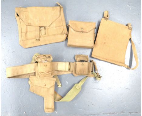
1937 Pattern Officer's Webbing Beltconsisting webbing belt ... Pair of shoulder straps ... Revolver holster ... Pistol ammunition pouch ... Compass case and compass ... Binocular case ... Map case ... Officer's side bag. Some items blancoed. Various wartime dates. PAYMENT BY BANK TRANSFER ONLY
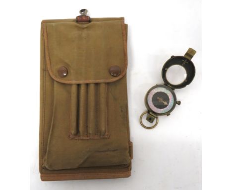
WW1 Dated Map Case And Compassgreen, fine canvas, rectangular, triple folding map case. The rear with pencil container. Single attachment hook. Interior of flap with maker "R Burns Ltd 1917". Together with a brass, military pattern, flip open lid compass. 2 items. PAYMENT BY BANK TRANSFER ONLY

-
109198 item(s)/page