We found 109198 price guide item(s) matching your search

Refine your search

Year

Filter by Price Range
  • List
  • Grid
  • 109198 item(s)
    /page

Lot 93

Anon. [Douglas (Robert)] The Baronage of Scotland .., 1798, folio, repair to title, text illustrations, calf; idem, The Peerage of Scotland .., 1813, 2 vols., folio, 17 engraved plates, quarter calf (re-backed); Stuart (Andrew), Genealogical History of The Stewarts ..., 1798, 4to., large folding table, tree calf (joints cracked, worming to lower margins of earlier pages); Anderson (John), Historical and Genealogical Memoirs of the House of Hamilton .., nd., 4to., frontis, quarter calf; Crawfurd (George) & Semple (William), The History of the Shire of Renfrew, 1782, small 4to., half calf; Crawfurd (George) & Robertson (George), A General Description of the Shire of Renfrew .., 1818, 4to., folding map (?of 2), folding charter, 4 engraved plates, cloth-backed boards (binding weak); Pont (Timothy) & Dobie (James), Cuninghame .., 1876, folding map, plates, cloth-backed boards; with a small quantity of others (qty)

Lot 105

Freeling (Arthur) The Windsor Railway Companion and Guide, to the Castle and Town; to Eton and its College; and to Virginia Water, 1840, folding map, original printed wraps (worn)

Lot 110

Walker Walker's Universal Atlas for the Use of Schools .., 1814, hand-coloured maps (world map present but detached, second world map with torn corner), half sheep (worn); Salmon (Mr), The Modern Gazetteer: or, a Short View of the Several Nations of the World .., 1782, 7 folding maps after Kitchin (creased), sheep (functional re-back); with four others (6)

Lot 111

Burton (Richard F.) First Footsteps in East Africa or, An Exploration of Harar, 1894, Memorial edition, 2 vols, maps, colour plates as called for, original cloth gilt; idem, Personal Narrative of a Pilgrimage to Al-Madinah & Meccah, 1893, Memorial edition, 2 vols., folding map, colour plates as called for, original cloth gilt; Westermarck (Edward), Ritual and Belief in Morocco, 1926, 2 vols., plate, folding map, t.e.g., with two others (8)

Lot 112

Turner (Samuel) An Account of an Embassy to the Court of the Teshoo Lama in Tibet, 1800, 4to., folding map, 13 plates, calf

Lot 114

[Anson (George)] [A Voyage Around the World in the Years MDCCXL, I, III, IV ..,], nd. [c1748], untitled plate volume only, containing 42 maps and plates, the majority folding, half sheep (well worn); Sonnini (C.S.), Voyage dans la Haute et Basse Egypte .., Collection de Plances, An VII [1798-9], plate volume only, 40 plates including large folding map, original wraps (worn); Edwards (Bryan), The History, Civil and Commercial of the British Colonies in the West Indies, Vol III, 1801, 4to., vol. 3 of 3 only, large folding map of St. Domingo, plates, original boards (worn); with one other (4)

Lot 115

Thomson (Arthur S.) The Story of New Zealand: Past and Present - Savage and Civilised, 1859, 2 vols., folding colour map, folding and other plates as called for, original cloth

Lot 118

'Yellow Body' Angling Days on Scotch Lochs, 1884, original cloth; 'Ex-President of the Kinross-shire Fishing Club, The Loch-Leven Angler, 1874, frontis, folding map (small tears), original cloth; Ransome (Arthur), Mainly About Fishing, 1959, first edition, dust wrapper; with five others (8)

Lot 129

Petrie (Henry) & Sharpe (John) Monumenta Historica Britanica, or Materials for the History of Britain, from the Earliest Period, Vol 1 (all published), 1848, folio, 27 plates, folding colour map, half calf (worn); [Domesday Book, seu liber censualis ... Vols I & II], nd., [1783], 2 vols., large folio, without titles or prelims as issued (issued in 1816 with further 2 vols.), distressed binding with detached boards; sold not subject to return; [both items from the library of the 1st Earl of Eldon at Encombe, Dorset]

Lot 25

The Universal Magazine of Knowledge and Pleasure, Arts and Sciences, pub, includes Map of Salop by Bowen and others, half calf (1)

Lot 54

COX`s Herefordshire 1718, with folding Morden Map of Herefordshire, description, index, etc, newly bound half calf and marbled board (1)

Lot 57

Itinerarium Angliae or a Book of the Roads of England and Wales, 254pp including Advert for Books Printed for William Bray and sold by John Morphew and James Wood, 4 parts bound in one, folding map

Lot 88

Map of Worcester, Folding map in 24 parts total area 52 x 30in, n.d. 1890 including parts of Monmouth, Glouster, Shropshire and Warks, hand coloured on canvas (1)

Lot 156

TWEEDIE, William, The Arabian Horse, His Country and People with portraits of typical or famous Arabians and other illustrations, folding coloured map in pocket at end, pub William Blackwood and Sons, 1st edit, 1894, green cloth binding with gilt figure of horses head and spine title (1)

Lot 428

A Cobridge Stoneware limited edition vase, dated 1999, decorated with a map of the world, in colours impressed and painted marks, 27/100 25cm. high

Lot 389

Box of assorted collectables to include Lady's three section purse, vanity mirrors & brush, large paper map of The South Coast of Ireland to Lands end plus others, framed Golfing print together with a oak cutlery box with assorted cutlery etc.

Lot 536

After Sam & Nathaniel Buck uncoloured engraving, The South East View of Conway Castle in the County of Caernarvon, coloured engraving, A New Map Of Caernarvonshire, a Map Of South Wales, West From London, framed & glazed. (3).

Lot 562

After Blaeu coloured map of Wales.

Lot 64

A watercolour, John S Wright, Ring O`Bells Kendal, a reproduction map and a decorative print

Lot 788

Mixed East Anglian prints, to include The South West Prospect of Ipswich, the South West Prospect of Colchester, Tankard street Theatre, Ipswich, Church of St Mary Le Tower, Ipswich, Flatford mill, The North West View of St Johns Abby in Colchester, The North East View of Colchetser castle and a map of Suffolk, (8)

Lot 949

G R Clarke, The history & Description of the town and borough of Ipswich, including the villages, County seats in its Vicinity, Ipswich, printed and published by S Piper, London, folding map and engravings, two volumes, (2)

Lot 959

John Kirby, "The Suffolk Traveller", 1764, Second edition, folding map of Suffolk, together with three further Suffolk Travellers, 1735, 1829 and another, also with a Supplement to the Suffolk Traveller, Augustine Page, 1844, (5)

Lot 967

Norfolk and Norwich remembrancer, and vade - mecum, containing a brief statistical description of the county and city; a chronological retrospect, Norwich printed and sold by Machett and Stevenson, 1822, folding map

Lot 972

T K Cromwell, Excursions in the County of Essex, 2 volumes, engraved titles, folding map and plan, and 95 plates, leather bound, (2)

Lot 986

Blaeu map of Paris, France, early 17th Century, Ager Parisiensis vulgo L`sle De France, framed, map size 51cm x 39cm

Lot 988

C L Tyler map of Hertford, circa 1826, hand coloured, 56cm wide

Lot 989

Carington Bowles folding map of Ireland, published 4th June 1782, cloth bound, 102cm wide x 122cm high

Lot 990

Circa 1646 map of Lothien, Gerard Mercator, Provincae Lauden seu Lothien et Linlitouo, hand coloured, 57cm x 39cm

Lot 994

Edward Stanford Ltd, folding map of the Malay Peninsula, 1st Jan 1913, 55.5cm wide x 65cm high

Lot 995

Four section folding black and white map on cloth, ` A new map of the County of Suffolk, taken from the original map published by Mr John Kirby in 1736, new publishment with corrections & additions by S.Piper, bookseller, Ipswich`, approx.152cm wide x 121cm high

Lot 996

Geological map of England and Wales, Prof.Ramsay.F.RS&G.S, folding cloth map 100cm x 85cm complete with case

Lot 998

H.Moll, coloured map of Suffolk, mounted, 35.5cm wide x 25.5cm high including mount, together with, Ric Blome, unframed coloured map of Suffolk, 35cm wide x 30.5cm high, (2)

Lot 999

J & C. Walker folding map of the world, reading `To Her Most Gracious Majesty Queen Victoria, This Map of the World on Mercator`s Projection, is most respectfully dedicated, By Her devoted Subjects, J & C. Walker`, published 1846, cloth bound, cut in two sections, 127cm wide x 80cm high

Lot 1000

John Kirby, unframed coloured map, `An Actual Survey of the County of Suffolk, taken from the original survey, published in the year 1736, but now contracted to half that scale by the author John Kirby according to act of Parliament 1737`, 73cm wide x 55cm high

Lot 1001

John Ogilby the Road from London to St Neotts, together with another road map by John Hinton, (2)

Lot 1004

J.C. Walker folding map, `Geological Map of England and Wales`, published December 18th 1835, with case, 100cm wide, 128cm high

Lot 1006

Robert Morden, coloured map of Suffolk, 52cm wide x 45cm high including frame

Lot 1009

Thomas Kitchen map of Hertfordshire, circa 1749, 69cm x 56cm

Lot 1010

Two folders of maps relating to Hertfordshire, dating from the 18th Century to the 19th Century, various map makers to include, Pieter Miejer, Thomas Kitchen, Joseph Ellis, Bowen, etc., (qty)

Lot 1011

Unframed coloured map, `A Map of the Liberties of Ipswich in the County of Suffolk, as ascertained by a perambulation, performed by the Bailiffs and other members of the Corporation, September 17th 1812`, 61cm wide x 53.5cm high

Lot 1012

William Kip early 17th Century map of Hertfordshire, titled Hertfordiae Comitatus A Cat tifuclanis olim inhabitatus, 39cm wide

Lot 1078

A box containing a box Brownie no.120 and case, first world war period brass cased compass dated 1915 in leather case, pair of binoculars, three various telescopes, map measuring instruments, a boxed Stuarts marine distance meter etc.

Lot 1235

18th Century needlework, map of England and Wales, of oval form, having floral needlework border with central map, by Rebecca Hunter, contained in beadwork decorated pine frame, 58cm wide x 67cm high including frame

Lot 29

(Muller, John) "A System of Camp-Discipline, Military Honours, Garrison Duty...to Which is Added General Kane's Campaigns...", London J. Millan 1760, coloured map frontis, plans and lists bound to the back to the back of the volume, various other maps and lists, inscription on title page (contemporary?), rebound, full calf, bookplate inside front cover and some pencil annotations, text clean and bright

Lot 52

"Sinn Fein Rebellion Handbook, Easter 1916", compiled by "The Weekly Irish Times", Dublin (1917 issue), folding map, various illus., advertisements inside front and back cover, paper covers

Lot 66

Boydell, John and Josiah "An History of the River Thames", two volumes, with additional Letter Press titles, "An History of the Principal Rivers of Great Britain", with dedications to both George III and Horace Walpole, large double folding map of the Thames, engraved frontispiece of head of Father Thames, seventy six handcoloured aquatints, the view of London folding in volume two has slight split on central crease, not affecting plate, tissue-guards to majority of plates, though some offsetting, slight foxing throughout volume 1, with some pages quite severe, contemporary full red morocco, gilt rules to front and back covers.

Lot 100

Map by I. Harris The East part of the River Thames and the West part of the River Thames, 24 x 38cm approximately, glazed and framed

Lot 101

Map of the County Gloucestershire, divided into 100's, published by Edward Stanford of Charing Cross, 45 x 35cm approximately, glazed and framed, another, "Plan of the town of Cheltenham, Gloucestershire", glazed and framed and one other small map, "Plan of the country in the vicinity of Cheltenham" (3)

Lot 103

Map Nicolas Sanson, D'Abbeville "Le Gouvernement D'orleans et la Generalite Divisse en ses Elections", coloured, with cartouche, some small tears, and a repaired tear at the top right hand corner, 54 x 73cm approximately, with Map S. Robert, "Carte du Royaume de France...les Routes des Postes", in 1758, 50 x 53cm approximately, and another Map "Asia Antiqua" (3)

Lot 110

Strip Map - John Ogilby "The Road Glocester to Coventry", in mount and "The Road from London to Portsmouth" (2)

Lot 112

Map "Aegyptus et Cyrenaica", possibly from the Old and New Testament by Humphrey Prideaux, 30 x 38cm together with a Print "Opening of the Buxton Matlock Railway from the Illustrated London News", (1863) (2)

Lot 115

Handcoloured map William Kip, map of Dorsetshire, glazed and framed, 28 x 39cm

Lot 116

Collection of small folding maps relating to London, including:- "Walkers, Middlesex", "Ludgate Hill", "W.H. Smith and Sons Plan of London", "W.H. Smith and Sons Reduced ordnance map of the River Thames", "The Picture of London for 1818", with various folding and other plates, "Map of the Country around London", published by W. Faden, "Blacks Guidebook to London" with folding map frontis, other folding plates and maps etc, green cloth, and a large folding map of London, published by J. Cross, linen backed (8)

Lot 117

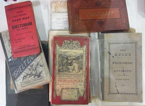
Quantity of ordnance survey maps, maps, guidebooks etc relating to Cheltenham and Gloucestershire, including:- Bath, Bristol, Swindon, Cirencester, Chipping Norton, Stow on the Wold, "Westley's New Cycling Road Map of Cheltenham", "Norman May's Guide to Cheltenham", folding map, "A New Guide to Cheltenham and its Environs", published by John Lee, linen back folding map frontis, original front boards, backstrip missing, front board detached, Williams, J.G.A. "A New Guide to Cheltenham...", printed for G.A. Williams, folding map frontis, folding plates, another map of Cheltenham, foxed, contemporary marbled boards, half leather with gilt titles, a folding map of the Great Western Railway and five other guides and maps, including:- Brighton, Isle of Wight and Oxford etc (27)

Lot 118

Various linenback folding maps, including:- Belgium, Germany etc, Bartholomew's New Reduced Survey Sheet 16, Braemar and Blair Athol, Phillips Atlas for Beginners, The Daily Mail Milestone Motor Map with index, in slipcase, the Comparative Atlas by J. Bartholomew and two other volumes (17)

Lot 119

Map "Central portions of South Australia", possibly Johnston, Edinburgh, (1880), 15.5 x 13.5 cm approx, within mount, Map "Tasmaina", 14 x 10cm, within mount, Map "Ancient Bath", 12 x 14.5cm, within mount, some slight tear, and "Plan of Ancient Rome", W.B. Clark, linen-backed, folding, Map "West Australia", by W and A.K. Johnston, Edinburgh and London, 26 x 20cm approx, within mount (5)

Lot 227

"Wonderful Egypt" forty eight artistic pictures in heliogravure, includes pencil drawing Cairo 1934 by B. H. Strahan and W. H. Toms, colour map of Egypt

Lot 239

Large quantity of ephemera including:- map, guides, railway items, photographs and magazines (1 box)

Lot 268

William C. A. Blew, "The Quorn Hunt and its Masters", London 1899, with illustrations after Henry Alken and a coloured map of the Quorn and surrounding counties, cloth, small 4to.

Lot 276

Romeyn de Hooghe "Carte Nouvelle de le Mar Mediterranee ou Sont Exactement Remarques tous les Ports, Golfes Rochers Bancs de Sable, etc" Amsterdam, Pier Mortier 1694 hand-coloured map, three sheets conjoined visible 60 x 102cms Footnote: A monumental antique sea chart of the Mediterranean Sea with thirty-eight insets of harbours.

Loading...Loading...
  • 109198 item(s)
    /page

Recently Viewed Lots