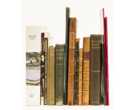

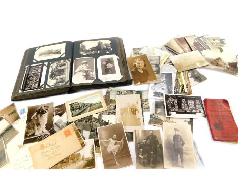
Kent.- Jacob (Edward) The History of the Town and Port of Faversham, in the County of Kent ..., folding engraved map frontispiece and 17 plates, 3 folding or double-page, occasional faint spotting, contemporary half-calf, rubbed, 1774 § Lewis (John) The History and Antiquities of the Abbey and Church of Faversham in Kent ..., 5 engraved plates, illustrations, contemporary manuscript note to preface, short tear to title, spotting, occasional water-staining, modern calf backed boards, [Canterbury], 1727 § Lillo (George) Arden of Feversham. an Historical Tragedy, first edition, tiny hole not affecting text, modern half-calf, for T. Davies, 1762 § Synopsis of the Museum of the Philosophical and Literary Institution, Canterbury, lithographed frontispiece and 2 plates, list of directors, corrected by hand, Canterbury, 1826, bound before, Annual Report of the Canterbury Philosophical and Literary Institution ..., [Canterbury], 1828, occasional spotting, contemporary straight-grain morocco, rubbed and worn; and 13 others on Kent, v.s. (17)
We found 109182 price guide item(s) matching your search
There are 109182 lots that match your search criteria. Subscribe now to get instant access to the full price guide service.
Click here to subscribe- List
- Grid
-
109182 item(s)/page

Kent.- Lewis (John) The History and Antiquities Ecclesiastical and Civil of the Isle of Tenet in Kent, first edition, 2 engraved maps, 1 folding engraved plate, illustrations, several full-page, 1723, bound before, The History and Antiquities of the Abbey and Church of Faversham in Kent ..., 5 engraved plates,[Canterbury], 1727, occasional spotting, contemporary calf, a little rubbed,§ Battely (John) Antiquitates Ruptupinæ, 4 folding engraved plates, browning, later morocco, lacking spine head, a little rubbed, Oxford, 1711; The Antiquities of Richborough and Reculver, engraved map frontispiece and plates, occasional spotting, contemporary calf, rebacked, a little rubbed, 1774; 4to & 8vo (2)
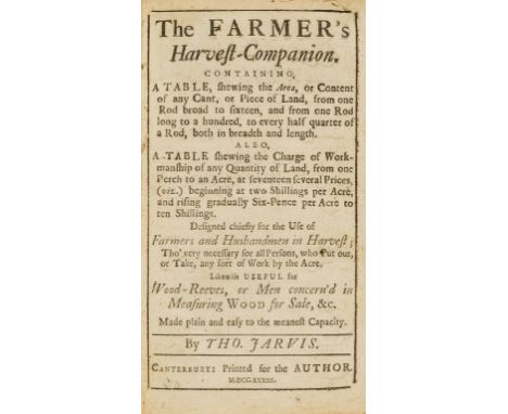
Canterbury imprint.- Jarvis (Thomas) The Farmer's Harvest-Companion, first edition, occasional spotting, previous owner's ink signature to front free endpaper and final leaf, short marginal tear (F1), contemporary calf, rubbed, slight bumping to corners and extremities, Canterbury, for the Author, 1733 § Cowell (M. H.) A Floral Guide for East Kent ..., hand-coloured double-page map frontispiece, engraved map, occasional very faint spotting, later half-morocco, rubbed, small loss to upper cover, Faversham, 1839; 8vo (2)

Smith (William, Rouge Dragon) The Particular Description of England 1588, one of 250 copies, folding chromolithographed map, additional pictorial title & 28 plates of coats-of-arms, city plans & views etc., all chromolithographed, some heightened with gold, 2 folding, spotting at beginning and end, prospectus tipped in at end, original Roxburghe-style roan-backed red boards, t.e.g., rubbed, spine ends a little worn, 4to, for subscribers only, 1879.

Europe.- Beattie (William) The Danube, its History, Scenery, and Topography, engraved additional vignette title, map and 78 plates after W.H.Bartlett, wood-engraved illustrations, some foxing, bookplate of David Henry Graham, original pictorial burgundy roan, gilt, a little rubbed and marked, slight wear to lower corners, rebacked preserving original gilt spine, 4to, 1844.
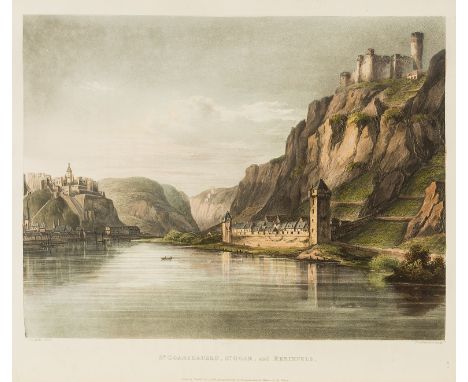
Germany.- Gerning (Johann Isaak von) A Picturesque Tour along the Rhine, from Mentz to Cologne, first English edition, list of subscribers, 24 hand-coloured aquatint plates after C.G.Schutz, folding engraved map with routes hand-coloured at end, frontispiece and title browned, some spotting or light offsetting to or from plates, later half red morocco, t.e.g., others uncut, a little rubbed, [Abbey, Travel, 217; Tooley 234], 4to, 1820.
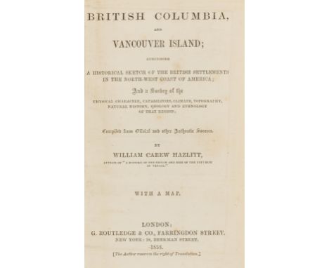
Canada.- Hazlitt (William Carew) British Columbia, and Vancouver Island, first edition, lacking half-title, with folding map, browned and torn at folds and laid down, modern half calf, [Sabin 31126], 8vo, 1858.⁂ Scarce early account of British Columbia with descriptions of the recently-discovered gold fields in the Fraser River area.
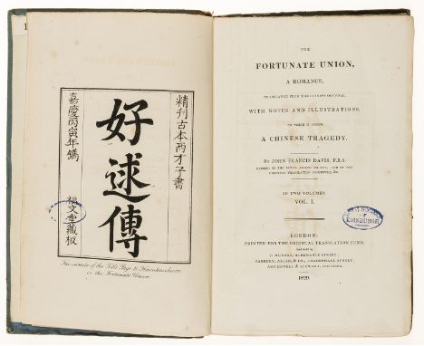
China.- Davis (John Francis) The Fortunate Union, a Romance...with...A Chinese Tragedy, 2 vol., first edition, half-titles, frontispiece, lithographed map, errata leaf at end of vol.1, foxing, ex-Royal Society of Ednburgh library copy with ink stamps to frontispiece and titles, original boards, uncut, spotted, spines worn and defective, 8vo, Oriental Translation Fund, 1829.
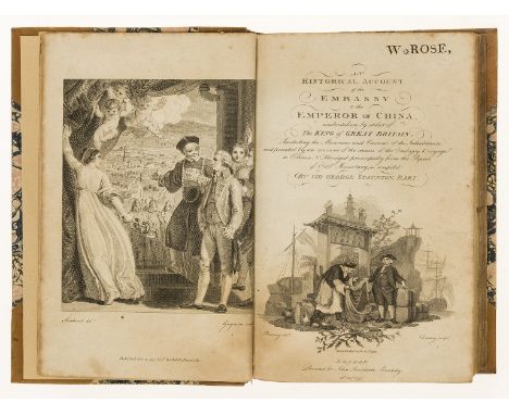
China.- Staunton (Sir George) An Historical Account of the Embassy to the Emperor of China, first 8vo edition, engraved frontispiece, additional vignette title, 2 folding maps, and 21 plates, with errata, 'Directions to the Binder' and 3 pp. advertisements at end, ownership stamp "W.Rose" to head of engraved title, a little browned and wrinkled, one map frayed at edge, modern bookplate of Sir Philip Rose, modern half calf, spine gilt, 8vo, John Stockdale, 1797.
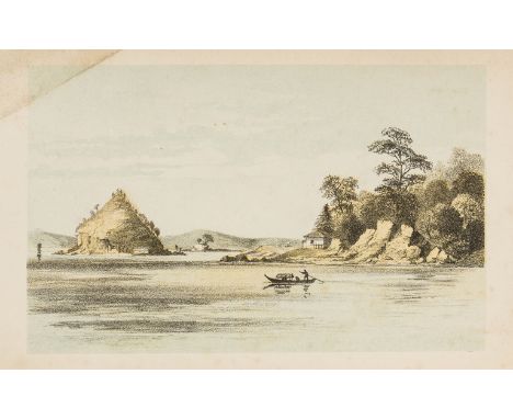
Japan.- Fonblanque (Edward Barrington de) Niphon and Pe-che-li; or, Two Years in Japan and Northern China, second edition, folding map, 10 plates, 3 folding, 6 chromo- or tinted lithographs, light foxing, frontispiece creased across lower outer corner, 1863 § Macfarlane (Charles) Japan; an Account, Geographical and Historical, first edition, half-title, wood-engraved frontispiece and illustrations, folding map (torn and repaired), a little browned, some spotting, 1852, both original pictorial cloth, gilt, rubbed, recased, new endpapers, 8vo (2)
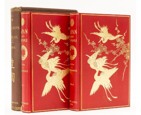
Japan.- Griffis (William Elliot) The Mikado's Empire, fifth edition, wood-engraved plates and illustrations, 8pp. catalogue of books on Japan from Kelly & Walsh of Yokohama tipped in at beginning, book-label of Rex & Co., Berlin, original cloth, very slightly rubbed, New York, 1886 § Hartshorne (Anna C.) Japan and her People, 2 vol., first edition, photogravure plates, captioned tissue guards, folding colour map, an excellent bright copy in original pictorial red cloth, gilt, red cloth dust-jackets, spines slightly faded and stained, together in original cloth slip-case (rubbed and stained), Philadelphia, 1902, 8vo (3)
Japan.- Milne (John) and W.K.Burton. The Great Earthquake in Japan, 1891, second edition, 30 photographic plates by Kazumasa Ogawa, printed on paper made in Echizen, captioned tissue guards, map, a few plates with light water-staining to lower margin, original cloth, rubbed and damp-stained, oblong folio, Yokohama, 1894.⁂ Superb photographic record of the devastating earthquake in Japan.

Signed, inscribed and dated 'Study from the Lorrypark Series, 1974, Joan Hills, Mark Boyle, Boyle Family', mixed media, resin and fibre glass (Dimensions: 183.5cm x 183.cm (72.25in x 72.25in))(183.5cm x 183.cm (72.25in x 72.25in))Footnote: Note: BOYLE FAMILY Their collective comprises husband, wife, son and daughter, but beyond being close family members, the Boyle Family are artistic collaborators. This began soon after Mark Boyle, a Glaswegian by birth, and Joan Hills, originally from Edinburgh, met whilst living in Yorkshire in the 1950s. Their children Sebastian and Georgia were exposed to studio life from an early age, ultimately opting to continue the collaboration into adulthood. Though initially exhibiting under Mark’s name alone, they began representing themselves as ‘Boyle family’ from 1985. Their work was experimental and cross disciplinary from the start, with famous early projects including innovative visual installations in collaboration with musicians like Jimi Hendrix and the Soft Machine. Elements of film and performance continue to play a part in their practise, but it is the Journey to the Surface of Earth series, launched in 1968-69, for which they are best known. Works from the Earth series are, in the Boyle Family’s own words, ‘three dimensional casts of the surface of the earth which record and document random sites with great accuracy. These works combine real material from the site (stones, dust, twigs etc) with paint and resins, preserving the form of the ground to make unique one-off pieces that suggest and offer new interpretations of the environment.’ Sites were selected on the map by the throw of a dart whilst blindfolded, and the precise patch of ground to be immortalised, narrowed down by the toss of a t-square over the shoulder. Like archaeologists, the Boyles would then focus on that particular section of earth and work meticulously to capture and recreate the site in resin and fibreglass. The full details of their materials, casting technique and how they achieve such accurate representations are a well-kept family secret. In 1974, they began creating casts in a site near their house in Shepherds Bush, which is now buried under the Westfield Shopping Centre. While trying to gain access to the private site, Mark asked the property owner for permission to take photographs. The owner asked if he was a professional photographer and, seeing no other way in, Mark pretended he was. In a twist of fate, the site owner was working on a planning enquiry to develop the land into a lorry park. The owner needed photos showing lorries illegally parked in the area at night, therefore showing the demand for a lorry park. These photographs were enough to award the owner planning permission, and he then granted Mark the permission to work on the site. In his book, Mark Boyle’s Journey to the Surface of the Earth , J.L.Locher recalled the unfettered access, stating ‘This gave us the opportunity to work freely on a wide range of studies, variegated earth, rubble, cracked earth, wet, moist, damp and dry mud, animal and bird footprints, and so on. As time went by these were grouped together as the Lorrypark Series.’ Lyon & Turnbull is delighted to offer a work from this series, titled Study of Cobbles, with Mud, Stones and Debris, Lorry Park Series, 1974 . This piece was potentially included in the Serpentine Gallery’s one-man exhibition of Mark Boyle’s work (4 Oct 1975 to 2 Nov 1975), which included artwork from the Earth series. The family would go on to represent Britain at the Venice Biennale in 1978, and again at the Sao Paulo Biennale in 1987. Their exhibition ‘Beyond Image’ at London’s Hayward Gallery in 1986 attracted 176,000 visitors, and the National Gallery of Scotland, Edinburgh, hosted a major retrospective of the family’s work in 2003. Though Mark Boyle passed away in 2005, the family continues their work. The Boyle Family is represented in many private and public collections with major works in forty museum collections worldwide, including Tate Britain; Stuttgart Staatsgalerie; Los Angeles County Museum; Kunstmuseum Luzern; Tokyo Metropolitan Museum; Museum Moderna Kunst Vienna.Condition report: The work appears structually sound. Due to the nature of the work, it is almost impossible to know if there has been any losses or damage. No visible signs of any major issues or losses. Overall it appears in good condition.
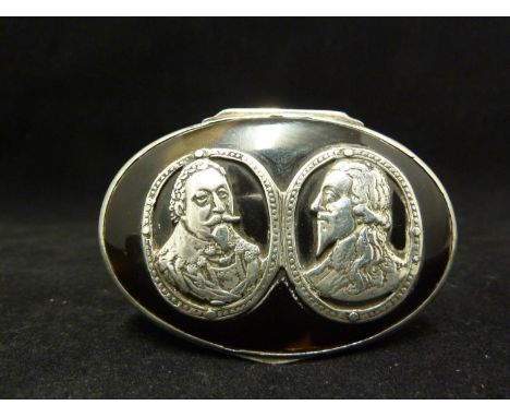
A white metal and pique work remembrancer snuff box, oval, the hinged cover decorated with a double portrait of Charles I, the base cast with a 'map' of Virginia with sailing boats, figures and houses, the sides with panels of trophies of war, a female bust portrait and monogramme beneath crown, 6.5cm max
![J.R.R. Tolkien, The Lord of the Rings Trilogy, first editions [George Allen & Unwin Ltd., 1954-1955] the complete set of 3 no](https://cdn.globalauctionplatform.com/a0ce64e7-2da1-4525-954b-aae700e19752/3c77c874-e8cc-43ea-8217-aae700e4d044/468x382.jpg)
J.R.R. Tolkien, The Lord of the Rings Trilogy, first editions [George Allen & Unwin Ltd., 1954-1955] the complete set of 3 novels, comprising: The Fellowship of the Ring (1954, endpapers very slightly browned, bookseller's label to upper pastedown: “Blackwells Oxford England”, contemporary ink inscription “Brian Morris, Oxford, August 1954” to front free endpaper), The Two Towers (1954, endpapers and pastedowns a little spotted) The Return of the King (1955, contemporary ink inscription “Brian Morris, Worchester College, Oxford, Michaelmas 1955” to front free endpaper), each with a large folding map after Christopher Tolkien, all in original red cloth, spines lettered in gilt, top edges stained red, original publisher's red, black and gilt dust-jackets, first two mentioned with old tape markings lining inner edges of jackets, spines darkened and extremities rubbed, third volume top edges of covers and spine darkened, all with some light restoration to extremities, preserved in modern cloth drop-box, 8vo An attractive set of Tolkien's masterpiece trilogy, often considered the singlemost important work of fantasy literature in the twentieth century.

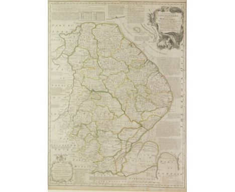
Blaeu, Johannes – 17th Century hand-coloured map of Dorset, Comitatus Dorcestria vulgo Anglice Dorsetshire, circa 1648, centre fold as issued, approx.. 38cm x 50.5cm, framed and glazed Condition: Thin plastic sheet to the reverse so not laid down, generally good condition though frame is tatty. **General condition consistent with age


DUNKIRK TO BERLIN MAPS SHOWING THE JOURNEYS OF CHURCHILL AND OTHERS. Dunkirk to Berlin June 1940-July 1945, a map of the Historic Wartime Journeys undertaken by the Right Hon. Sir Winston Churchill, K.G., O.M., C.H. In Defence of the British Commonwealth and Empire. A large folding map in slipcase issued by the Reprint Society, 1956. The Times Map of the Western Front and the Autocar folding map of Scotland. (3)
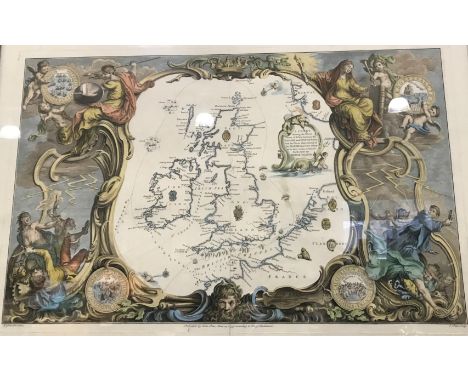
JOHN PINE MAPS SHOWING THE PROGRESS OF THE ENGLISH AND SPANISH FLEETS DURING THE ARMADA. A map of the British Isles titled 'A chart shewing the several places of action between the English and Spanish where several of the Spanish ships were destroyed in their return to Spain, North about the British Islands.' The map within decorative coloured allegorical borders. Together with five double maps showing the progress of the two fleets, each annotated in the margin H.Gravelot delin. and J.Pine Sculp. Published by John Pine, June 24. 1739 according to Act of Parliament, and with elaborate decorative borders. Also a similar map 'Thamesis Descriptio' showing the defenses of the Thames. Framed and glazed, 22 1/4 x 31 inches and smaller with varying margin sizes. These maps were produced for the volume 'The Tapestry Hangings in the House of Lords' first published by John Pine in 1739. The maps are accompanied by a small framed and glazed descriptive text. (8)

A copper engraved map of a journey from Hang-Tchoo-Foo to Quang-Tchoo-Foo, inscribed: 'Carte de la Route que l'Ambassade Anglais a Suivre en Allant de Hang-Tchoo-Foo, Quang-Tchoo-Foo on Canton en Chine', Plate XXXlX, written in French, Gravee par Tardieu l'Aine, rue de Sorbonne No. 385, 48.5 x 68.5cm, and a map of Hsi-Shan or Western Hills of Peking, inscribed 'General Map shewing relation of Western Hills and railway lines and Peking' 1/500.00 scale, published by Henri Vetch at the French Bookstore, Peiping 1933, prepared by W. Lewisohn l / Xl / 32, drawn by Shens Siao-Tche, 78.5 x 108cm (2)


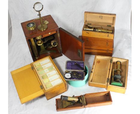
A collection of 70 microscopic slides with miniature photos of paintings and fossils, insects and fauna from around the world, together with a large cased microscope and five various cased small monocular microscopes including an example by J H Steward, a map reading magnifier and other optics

A collection of WW2 and later Tissue and Silk Escape Maps,Tissue map of Yugoslavia and Southern Italy (WW2). Silk maps: Lower France and Spain- Northern France and Belgium (WW2); Norway Sweden Finland U.S.S.R. (Post WW2); Rasht (1952); S.Japan 44/V with N.Japan 44/W; Tunis/Marseille (1953); Roma-Sarajevo Tunis-Palermo (1953); Stockholm-Riga Oslo-Stockholm (1951); Ivanovo/Moskva 1952 (3); Burma Siam French Indo China China (1950's). In unissued condition. (14)
The Flags of the United Nations,a set of 138 silver flags, each with the flag of the relevant country on the obverse and the map and name of the country on the reverse. Housed in wooden presentation display case with two separate trays, and binder with full details of each country. Extremely fine. (Lot)
A collection of WW2 and later Tissue and Silk Escape Maps,Tissue map of Yugoslavia and Southern Italy (WW2). Silk maps: Lower France and Spain- Northern France and Belgium (WW2); Norway Sweden Finland U.S.S.R. (Post WW2); Rasht (1952); S.Japan 44/V with N.Japan 44/W; Tunis/Marseille (1953); Roma-Sarajevo Tunis-Palermo (1953); Stockholm-Riga Oslo-Stockholm (1951); Ivanovo/Moskva 1952 (3). In unissued condition. (13)


G. CLARK SCALDWELL (fl. c.1825)'The Silk Mill, Burton Latimer, Northamptonshire'inscribed 'Drawn by G. Clark Scaldwell' and further inscribed as titlegrey wash8 x 10 1/2 in The North Water Mill at Burton Latimer, Northamptonshire was situated on the River Ise. On Bryant's 1826 map of the district it is referred to as 'The Silk Mill'. It appears to have been used for various types of textile manufacture until the 1860s.


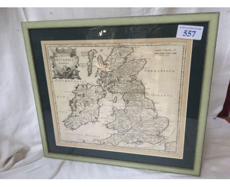
Sale Item: MAP BRITANNIA ROMANA Vat Status: No Vat Buyers Premium: This lot is subject to a Buyers Premium of 15% + Vat @ 20% Additional Info : Lots purchased online with the-saleroom.com will attract an additional charge for this service in the sum of 4.95% of the hammer price plus VAT @ 20%

Sale Item: SCROLL WALL MAP WORLD (AF) Vat Status: No Vat Buyers Premium: This lot is subject to a Buyers Premium of 15% + Vat @ 20% Additional Info : Lots purchased online with the-saleroom.com will attract an additional charge for this service in the sum of 4.95% of the hammer price plus VAT @ 20%
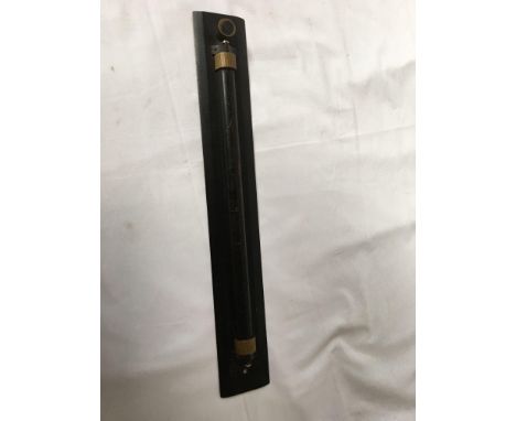
Sale Item: MILITARY MAP CHART ROLLER RULE Vat Status: No Vat Buyers Premium: This lot is subject to a Buyers Premium of 15% + Vat @ 20% Additional Info : Lots purchased online with the-saleroom.com will attract an additional charge for this service in the sum of 4.95% of the hammer price plus VAT @ 20%


-
109182 item(s)/page