We found 109182 price guide item(s) matching your search

Refine your search

Year

Filter by Price Range
  • List
  • Grid
  • 109182 item(s)
    /page

Lot 423

W. H. Ireland - "England's Topographer or A New and Complete History of the County of Kent", published by George Virtue, Ivy Lane, Paternoster Row, London, July 1828 (four volumes complete with folding map of Kent and numerous steel engravings, all fully bound in dark green leather), and J.M. Russell - "The History of Maidstone", published by William S. Vivish, 28 Kings Street, Maidstone 1881 (one volume), and Mr Marshall - "The Rural Economy of the Southern Counties", London 1798 (volume one of two volumes bearing library stamp "The Castle St Helena", latter both with leather bindings)

Lot 965

A good Webley .55 brown leather holster with brass cleaning rod, a brown leather bandolier with five pouches, and a leather map case

Lot 149

Johnson & Browning, New York. Carte de la Floride.Gravure vers 1861, certificat d'authenticité au dos.33x39 cm.This map of Florida was published by Johnson & Browning of New York in 1861. Compiled, drawn and engraved under the supervision of J.H.Colton and A.J. Johnson, this map was part of johnson's New Illustrated Family Atlas. The coloring is a combination of block printing and hand stencil.Beaux-Arts Paintings & SculptureCartes - Maps - Karten

Lot 235

Gregor Grey (fl.1870s-1911) DUCKLINGS, 1893 oil on canvas signed and dated lower left 13½ x 20¾in. (34.29 x 52.71cm) Gregor Grey was the son of Charles Grey RHA (c.1808-1892) and brother of the painters Alfred Grey RHA (1845-1926), Edwin Landseer Grey and James Grey and the engraver Charles Malcolm Grey. Gregor exhibited every year at the RHA from 1877-1911, averaging three to four exhibits a year - the most that a non-RHA member could possibly hope to have accepted. He also showed twice at the Oireachtas Art Exhibitions of 1906 and 1907. His works tended to be on a rustic theme and featured quaint, aneccdotal titles. Grey earned - albeit unwittingly - some modicum of posterity when James Joyce included in Ulysses a character called Gregor Grey who was the designer of Gallaher's map and whose career was given "a leg up" by illustrating an advertisement.

Lot 310

A small collection of 17th and 18th century European maps, including an 18th century map of Palestine and an 18th century panorama of Sens

Lot 737

A framed antique map of Chester 'The Countye Palatine of Chester with that Most Ancient City Described'

Lot 172

Box of maps, mainly English counties and Europe, to include Thacker's Railways in India 1897 and Calcutta, a linen 1919 map of Kashmir & Jammu & Punjab, an 1887 town plan of Bolton and many others.

Lot 240

After Pierre Du Val, Map of the Canary Islands, 34 x 51cm.

Lot 64

Japanese bronze table medal, Korea annexation commemorative Meiji 43 (1910) with case, flowers over a map of N.E. Asia, Osaka Mint mark rim stamp, 5.4cm dia.

Lot 94

Scrap book 19th C, including map of the city of Bermuda on the Summer Islands, 1830 Indian lithographs, and three volumes of The Penny Magazine, c. 1833/4 and 1840 (4)

Lot 400

A collection of various local watercolours and prints including Southwold Lighthouse, Snape Bridge, Snape Maltings, Orford Castle, map of Suffolk etc.

Lot 12

A maple framed map of Suffolk

Lot 335

John Speede, coloured engraving, Map of Sussex Described, 39.5 x 52.5cm

Lot 337

Robert Morden, Map of Norfolk, 39 x 60cm

Lot 358

Jansson Map of Orcadum et Schetlandiae (Orkney and Shetland Isles), 49 x 59cm

Lot 2200

A World Map and a Caribbean Map Prints

Lot 2174

A quantity of Prints to include Horse's head, Lecy Print, Map of South Wales, Newts and Marguerite

Lot 2062

A quantity of Prints to include an old map of Herefordshire, two Lowry Prints, 'Signing the New Leas' after a picture by Erskine Nico, fishing etchings, etc

Lot 571

Johannes Blaeu (Dutch, 1596-1673): a map of Suffolk, Mare Germanicum, 1646, hand coloured, trimmed edges, with the River Stour and other details annotated by hand, lower right, 40 by 50cm.

Lot 714

A WWII Ordnance Survey map of Greater London, Military Edition 'Not to be published' Special District (Relief) Map, First Pub. 1935, together with a pair of binoculars, a Chestermans tape measure, a WWII Wren's dark blue felt cap, button and three badges, and two leather and snake skin covered flasks, circa 1940's, one with cast white metal lid, 20cm. (10)

Lot 743

FLOR DE DINDIGUL INDIAN CIGARS FRAMED ADVERT. Multicoloured 27 by 21ins, turban wearing Indian, map of India behind pictured holding box of cigars in one hand bunch of cigars in other. FLOR DE DINDIGUL/ INDIAN CIGARS/ 8 GOLD MEDALS. Good. (8/10) NR

Lot 404

A map of Brenchley in the county of Kent, together with three prints, 'Tonbridge Wells from the Common', 'Bedgebury, Kent, The seat of Francis Law Esq' and 'Sandwich, Kent'.

Lot 1423

An old unframed Map print of Norway

Lot 1204

A C. Greenwood Map of Wiltshire from a Survey made in years 1819 and 1820 published December 12th 1820, 45 1/4 x 57 3/4", some damage

Lot 1085

A H. Moll framed Map of Monmouthshire along with a Folder containing a quantity of unframed Maps to include J. Cary Map of Wiltshire, other Maps of Monmouthshire, Brecknockshire, and unframed engravings, etc.

Lot 1390

A 19th c. book of hand written Music scores accompanied by a letter referring to Insurance dated 6th May, 1882, a leather bound gold leaf edged Book in Latin 'Forest School', inscribed 'Forest School Prize for Greek Studies, award to H. May, 1874, together with a 1950's road map of East Africa.

Lot 696

Four Framed and Glazed Antique Map Engravings - Huntingdonshire, Faringdon Ward, Scotland and Mediterranean

Lot 645

Antique Robert Morden Hand Coloured Map of Shropshire together with an Antique H Moll Black and White Map of Berkshire

Lot 622

Robert Morden gilt framed 18C hand coloured county map of Durham

Lot 622A

J Cary framed 18C hand coloured map of Wiltshire

Lot 201

A COMPREHENSIVE CASED TECHNICAL DRAWING INSTRUMENT SET, various RULE and SLIDE RULES, some cased, a "G.W.R." RAILWAY MAP, and a leather cased PAPERWEIGHT

Lot 423

JOHN SPEEDE AN EARLY MAP OF WARWICKSHIRE with town plans and the Arms of The Earls of Warwick, hand coloured, bears date 1469, 38cm x 51cm, glazed to reveal text verso and TWO OTHER FRAMED MAPS OF WARWICKSHIRE

Lot 428

AN EARLY MAP OF GREECE, hand coloured, 36cm x 47cm in plain wood glazed frame

Lot 437

AFTER JAN BLAEU "Comitatus Nottinghamiensis" (Map of the County of Nottingham), a 17th century hand coloured engraved Map, with text verso, having ornamented figurative titles and armorials, 43cm x 53cm in Hogarth double glazed frame (front and vers o)

Lot 88

Map of Jersey after the 1595 Mercators map, 6" x 8.5" framed

Lot 92

A Robert Morden map of Dorsetshire, 14" x 16.5" centre crease, sold by Abel Swale etc

Lot 91

A Robert Morden map of Devonshire, hand-coloured, 14.5" x 17", centre crease with partial split, Hogarth frame, sold by Abel Swale etc

Lot 1408

An antique map of Cornwall by Robert Morden; together with four further old maps.

Lot 1430

An antique hand-coloured map of 'The Smaller Islands in the British Ocean', by Robert Morden, 38 x 44cm.

Lot 1432

An antique coloured map of Buckingham, by J Blaeu, I.41.5 x 27.5cm.

Lot 99

Agnes B ladies wrist watch with world map face

Lot 315

AFTER WILLIAM KIPP "Dorsestraie", black and white map engraving, later hand-coloured

Lot 519

Speed (John) The West Ridinge of Yorkeshyre with the most Famous and fayre Citie Yorke described, 1610 or later, John Sudbury and George Humbell [Humble], hand-coloured engraved map, an early issue with scrollwork border, inset town plan of York, strapwork cartouche and seven armorials, 385 x 510mm, browned, small margins; English text to verso, unframed [and] The North and East Ridins of Yorkshire, 1610 or later, Sudbury and Humble, hand-coloured engraved map with inset plans of Richmond and Hull, wide margins (chipped), framed and glazed (2)

Lot 384

A Long Service medal with bars marked 1949 and 1959, a 1914-1918 British War medal and a 1919 Victory medal, together with a silk handkerchief map "unconditional surrender"

Lot 170

After Harrison,'A Map of Warwickshire engraved from an actual survey with improvements',hand coloured engraving,47 x 35 cm,framed and glazed

Lot 292

Ireland.- A survay of the towne & landes of Ballinebruoly [Ballynaboley] in ye countie of Kilkenny... Survay'd for Crafford Esq..., manuscript estate map, pen and ink, torn and repaired, folds, edges with tears, 395 x 305mm., 20th February 1698; and another small survey of land in Ireland, 1704, v.s., v.d. (2).

Lot 387

Britain in India & Central Asia.- Edwardes (Maj. Herbert B.) A Year on the Punjab Frontier, in 1848-49, 2 vol., first edition, engraved portrait, plates and plans, some folding, 3 chromolithographed plates, large folding engraved map with routes supplied by hand (mounted on linen), contemporary half calf, joints split, 1851 § Cotton (Lt.-Gen. Sir Sydney) Nine Years on the North-West Frontier of India, from 1854 to 1863, engraved frontispiece, folding map, some spotting and soiling, 1868 § Hutchinson (Col. H.D.) The Campaign in Tirah 1897-1898, folding map, plates, 1898, first editions, all but the first original cloth, the second rebacked preserving old spine, the last damp-stained, all rubbed; and 2 others on Chitral, 8vo (6)

Lot 388

Britain in India & Central Asia.- Edwardes (Maj. Herbert B.) A Year on the Punjab Frontier, in 1848-49, 2 vol., presentation copy from the author to Sir John Hobhouse with printed leaf in red tipped in at beginning, engraved portrait, plates and plans, some folding, 3 chromolithographed plates, lacking large folding map, 1851 § Nevill (Capt. H.L.) Campaigns on the North-West Frontier, plates and maps, 5 folding and in pocket at end, 1912 § Kaye (J.W.) Lives of Indian Officers, 2 vol., ink inscriptions on titles, some gatherings becoming loose, 1867, first editions, original cloth, the first pictorial gilt and rebacked preserving original spines, all rubbed, most spines faded; and 6 others, India, mostly North-West Frontier but including a defective copy of vol.V of The Delhi Sketchbook of 1854, 8vo & 4to (11)

Lot 391

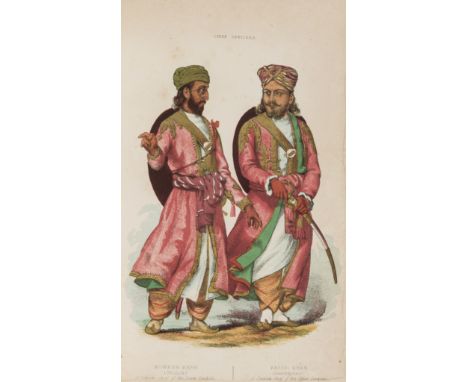
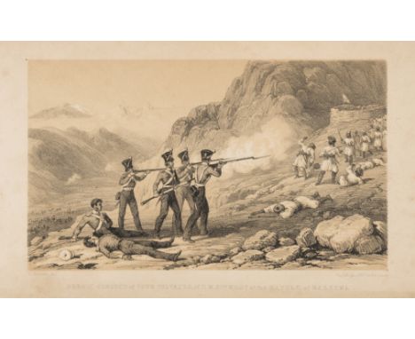
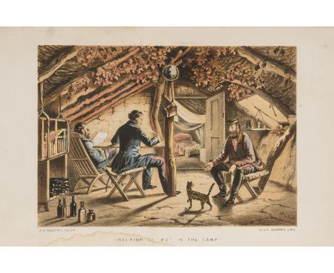
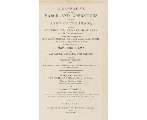
Britain in India & Central Asia.- Greenwood (Lt. Joseph) Narrative of the late Victorious Campaign in Affghanistan, under General Pollock..., first edition, tinted lithographed frontispiece, 4 engraved plates, folding map, some leaves slightly frayed at fore-edge, 1844 § Sale (Lady Florentia) A Journal of the Disasters in Affghanistan, 1841-2, first edition, with advertisement for 'Portraits of the Cabul Prisoners' on blue paper tipped in at beginning, 2 lithographed maps, one folding, 12pp. publisher's catalogue at end, 1843 § Eyre (Lt. Vincent) The Military Operations at Cabul, fifth edition, folding lithographed plan, 4pp. catalogue at end, 1843 § Ashe (Major Waller, editor) Personal Records of the Kandahar Campaign..., occasional spotting, 1881 § Forbes (Archibald) the Afghan Wars 1839-42 and 1878-80, plates and plans, 6pp. publisher's catalogue at end, 1892 § Masson (Charles) Legends of the Afghan Countries. In Verse, foxed and soiled, 1848, some foxing, the first two modern cloth preserving original cloth on upper covers, the rest original cloth, rubbed or worn, some spines faded; and 9 others on Afghanistan including vol.1 & 2 only of Masson's 3 vol. Narrative...in Balochistan, Afghanistan, and the Panjab of 1842, 8vo (15)

Lot 392

Britain in India & Central Asia.- Hamley (Lt.-Col. E.Bruce) The Story of the Campaign of Sebastopol, 9 lithographed plates, some chromolithographed or finished by hand, 2 folding, folding map, contemporary half calf, rebacked, Edinburgh & London, 1855 § Ferrier (J.P.) Caravan Journeys and Wanderings in Persia, Afghanistan, Turkistan, and Beloochistan, 2 plates, folding engraved map, ex-library copy, later half calf, 1856 § Wolff (Rev. Joseph) Narrative of a Mission to Bokhara..., third edition, lithographed portrait on india paper and mounted, 16pp. publishers' catalogue at end, original cloth, faded and stained, spine ends worn, 1846 § Marvin (Charles) The Russians at Merv and Herat..., plates, folding map, original pictorial cloth, recased, new endpapers, 1883, all but the third first editions; and 2 others including a fourth edition of the third, 8vo (6)

Lot 393

Britain in India & Central Asia.- Hough (Major W.) A Narrative of the March and Operations of the Army of the Indus, in the Expedition into Affghanistan in the years 1838-1839, first edition, folding lithographed map with outline hand-colouring, with 95pp. Appendix, Errata & Addenda at end and slip re Addenda bound in at beginning, map and title lightly foxed, modern half morocco, spine gilt and slightly rubbed & faded, 8vo, Calcutta, 1840. ⁂ Scarce first edition of the account of the British advance into Afghanistan during the First Anglo-Afghan War of 1839-42 which ended in disaster. The first English edition was published the following year.

Lot 409

Middle East.- Ortelius (Abraham) Palestinae sive Totius Terrae Promissionis Nova Descriptio, the Holy Land and Nile Delta, with north oriented to upper right, large strapwork title and dedication cartouches, with five ships and a sea monster, engraved map with original hand-colouring, 350 x 460mm., Latin text verso, browning at foot of central fold, [vdB 171], Amsterdam, [1592].

Lot 412

Polar.- Nansen ( Fridtjof) Through Siberia: The Land of the Future, translated by Arthur G.Chater, first edition, half-title, 3 folding maps, numerous plates, ink inscription on front free endpaper, original cloth, rubbed, spine a little faded, split to lower joint, 1914; "Farthest North" being the Record of a Voyage of Exploration of the Ship Fram 1893-96..., 20 original parts, first edition, with numerous plates and illustrations but lacking the loosely-inserted colour lithograph plate and folding map, advertisement leaves at beginning and end of most parts (browned), original pictorial wrappers printed in red and black, uncut, a little rubbed, slight fraying or chipping to spine ends, preserved in two modern cloth folders and slip-cases, 1898, 8vo (3)

Lot 414

Polar.- Pitt (Moses), A Map of the North-Pole and the parts Adjoining, with vignette view of Inuit's spear fishing and a European whaling expedition, with inset map of Nova Zembla, engraved map with hand-colouring, on laid paper, 460 x 590 mm. (18 1/8 x 23 1/4 in), central vertical fold, light even browning, surface dirt, handling creases, 1680

Lot 420

World.- Hall (Sidney) A New General Atlas..., 53 hand-coloured double-page engraved maps mounted on stubs, with Addenda/Erratum slip to Index, title browned and frayed at upper edge, maps with occasional light foxing but generally clean, creasing to Index leaves at end especially final leaf, contemporary half calf, worn, lacking upper cover, lower cover & spine detached, Longman, Brown, Green, and Longmans, [?1849] § Black's General Atlas, 61 engraved maps by Hall, Hughes & others, all but 2 hand-coloured, 15 double-page (7 with 2 maps joined together and mounted on stubs), some browing or soiling, water-staining to lower outer corner but not affecting maps, contemporary half morocco, a little worn and stained, Edinburgh, A. & C.Black, 1851, folio; sold not subject to return (2) ⁂ The first is with the map of Australia showing only Western Australia, New South Wales, Australia Felix, and South Australia; Van Diemen's Land divided into 19 Police districts (counties); the United States with "Northwest Territory", "Indian Territory", New Mexico and Texas at the western edge; British North America with "Upper California", Oregon and Alaska as "Russian Territory".

Lot 127

J. Alfred Watts, Map of the Colony of Natal, compiled and lithographed by J. Alfred Watts, partly by permission from plans in the Office of the Surveyor-General, showing lands in the hands of the Government (copyright) six miles = 1 inch, 1855.

Lot 380

Saxton (Christopher & Kip, William), Suffolciae Comitatus, hand-coloured engraved map, attractive strap work title cartouche,framed and glazed. The mount reads William Kip-1607,approx. 29 x 37 cm. together with a John Ogilby - Ogilby's Britannia (1675) The Road from London to Norwich, hand-coloured engraved map, attractive title, approx 42 x 37 cms and two printed maps of Gloucestershire and Norfolk. (4)

Lot 294

Kenner Star Wars Droids Side Gunner. VG in G box with inner packaging, unused decals, instructions, Planetary Map and marketing questionnaire.

Lot 295

Kenner Star Wars Droids A-Wing Fighter. VG in G box, with inner packaging, instructions, Planetary Map and unused decals.

Lot 244

Two 20th Century watercolours, one by D.N. Morgan, a woodland scene, signed, 36cm x 47cm and a loch scene signed Grieg Hall, a reproduction print Squadron Leader Douglas Bade, with signature below, 26.5cm x 21.5cm and modern screen-prints, 'view of Westbourne Grove and View of Braziers Park' and another modern print , Christina M. C. Sheriff 'Fishers Lane from the River Cambridge' 1929, Etching, Signed in pencil to the margin, 23cmx 26cm, a map of Egypt, John Tallis and Company, London and another of Mexico, acolour print of a soldier standing beside another on horseback, 40cm x 30cm and a print of a figure looking towards a cottage

Loading...Loading...
  • 109182 item(s)
    /page

Recently Viewed Lots