Forum Auctions
Lot 162
NO RESERVE Dorset.- Speed (John) Dorsetshyre With the Shyre towne Dorcester described, engraved map with hand-colouring, on laid paper with armorial watermark, platemark 385 x 510 mm. (15 1/8 x 20 1/8 in), sheet 420 x 545 mm. (16 1/2 x 21 1/2 in), Latin text verso, with woodcut initial by William Hall, overall browning, with several significant tears and temporary repairs, surface dirt, unframed, Sudbury and Humble, [1610-1611] § Speed (John) and Henry Overton. Dorsetshyre With the Shyre towne Dorcester described, engraved map, platemark 385 x 510 mm. (15 1/8 x 20 1/8 in), sheet 465 x 565 mm. (18 1/4 x 22 1/4 in), central vertical fold with slight browning, minor surface dirt, unframed, Henry Overton, [1662 but circa 1740s] § Saxton (Christopher) and William Kip (engraver). Dorcestriae Comitatis Vulgo Dorsett, engraved map, platemark 275 x 390 mm. (10 3/4 x 15 3/8 in), sheet 335 x 440 mm. (13 1/4 x 17 1/4 in), central vertical fold with some splitting, handling creases, some sheet loss to upper left and right hand corners, unframed, [circa 1607 and later]; together with a map of Dorset by Robert Modern, and two others by Cary and Charles Smith, engravings, various sizes, 480 x 540 mm. (19 x 21 1/4 in), and smaller, occasional surface dirt, minor nicks and tears, all unframed, 18th and 19th century (6).


![World.- World War.- Petersen (C.C.) Map of the World War Fronts [recto]; World map centred on the Pacific Ocean [verso], fift](https://cdn.globalauctionplatform.com/b079d8b6-c9f1-44ba-a4d1-a96600ab5dd9/26b48168-6acd-4b58-88f9-fb19fea45b6f/468x382.jpg)


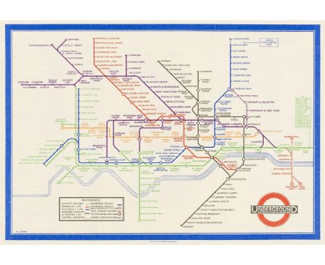
![London Underground.- Beck (Henry C., "Harry") [Map of London's Underground Railways], Edition No. 2 1936, diagrammatic underg](https://cdn.globalauctionplatform.com/b079d8b6-c9f1-44ba-a4d1-a96600ab5dd9/f84dcd81-c6f0-4456-a5ae-8f42e988f799/468x382.jpg)


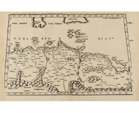
![Africa.- Fries (Lorenz) [Tabula I Aphricae], trapezoidal Ptolemaic map covering Morocco, Mauritania, the Western Sahara, Alge](https://cdn.globalauctionplatform.com/b079d8b6-c9f1-44ba-a4d1-a96600ab5dd9/0a3e6eb8-973d-490a-b229-bf8df1b62536/468x382.jpg)
![Florida.- Peru.- Ortelius (Abraham) Peruviae Auriferae Regionis Typus [on sheet with] La Florida [and] Guastecan Reg, three m](https://cdn.globalauctionplatform.com/b079d8b6-c9f1-44ba-a4d1-a96600ab5dd9/a0693977-a99f-4063-bf9e-2708cd8dcd3a/468x382.jpg)