We found 109198 price guide item(s) matching your search
There are 109198 lots that match your search criteria. Subscribe now to get instant access to the full price guide service.
Click here to subscribe- List
- Grid
-
109198 item(s)/page


Lot 522
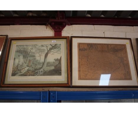
Four framed maps, various, including: an 18th century hand-coloured engraved Map of Kent, ('Engraved for J. Harrison, No 115, Newgate Street, 8th June 1789'); 'The Howard Vincent Map of the British Empire'; 'Cassell's Map of the Environs or Twenty Miles Round London' and 'Environs of London - Windsor Castle to Gravesend' (4)


Lot 132
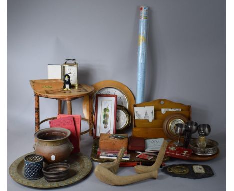
Interesting Collection to Mrs Irene Rush, Fire Guard Instructor and Inspector in Derby WWII, Includes Fire Guards Certificate, authorisation card to make inspections and similar to carry out instruction (Signed). Particularly noteworthy is her notebook giving details of the factories she has visited with comments " no one on duty.. two of the men Orme and Pickstock had signed on duty..and had gone to the Boxing Tournament" Together with map of each numbered Fire area in Derby with her name at the top. (5 items in all)

Lot 1A
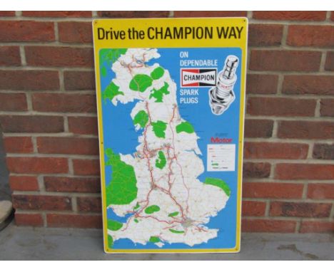
Champion spark Plug SignMake: Contact AuctioneerModel: Contact AuctioneerYear: Contact AuctioneerMileage: Contact AuctioneerVIN: Contact AuctioneerRegistration: Contact AuctioneerConfiguration: Contact AuctioneerTransmission: Contact AuctioneerDrive the Champion Way Champion Spark Plugs Map Sign. dated 1973 18 x 30 inches. One of the lots that have kindly been given to us by customers and which are to be offered prior to the cars on Saturday. All proceeds to be donated to the East Anglia Air Ambulance and Lennox Children's Cancer Fund. A special thanks to the current contributors including Dave Day, Harry Block, Kim Cairns, Ali McMordie (bass player in Stiff Little Fingers), James Henderson, Guy Snelling and items from the estate of Lloyd Baker 'Spider'
Lot 1D
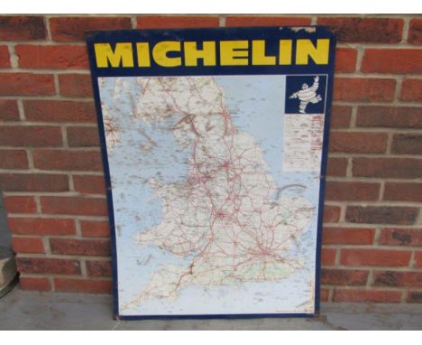
Michelin Tyres Tin Map Sign Make: Contact AuctioneerModel: Contact AuctioneerYear: Contact AuctioneerMileage: Contact AuctioneerVIN: Contact AuctioneerRegistration: Contact AuctioneerConfiguration: Contact AuctioneerTransmission: Contact AuctioneerMichelin Tyres Tin Map Sign 25 x 34.5 inches.One of the lots that have kindly been given to us by customers and which are to be offered prior to the cars on Saturday. All proceeds to be donated to the East Anglia Air Ambulance and Lennox Children's Cancer Fund. A special thanks to the current contributors including Dave Day, Harry Block, Kim Cairns, Ali McMordie (bass player in Stiff Little Fingers), James Henderson, Guy Snelling and items from the estate of Lloyd Baker 'Spider'
Lot 211
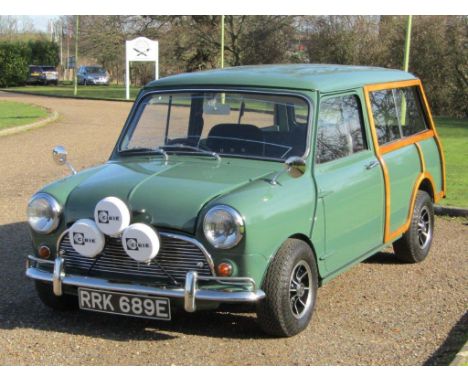
1967 Morris Mini Traveller 1275 Downton Cooper 'S' SpecificationMake: Morris Model: Mini Traveller 1275 Downton Cooper 'S' SpecificationYear: 1967Mileage: Contact AuctioneerVIN: MAW4927668Registration: RRK689EConfiguration: Right hand driveTransmission: ManualPurchased new by a Mr Deith of Woodford Green, a keen amateur rally driver, this Traveller was promptly prepared for competition use with the fitment of a MK III 1,275 S Cooper engine with thick flange block and retaining the original one and a quarter SU carbs. In July 1970, the car was despatched to world renowned Downton Engineering, the BMC performance tuning and rally conversion specialists, who uprated the car to their Downton No. 3 conversion. It is believed that following several years of competition use, the car was placed into storage and virtually forgotten about. Fast forward to early 2016 when we, at ACA, were contacted by an Essex based storage company regarding the potential sale of a Mini they wished to dispose of in order to cover outstanding storage fees. After recognising the Cooper S engine and looking through the paperwork, we realised that we had found a very special car. Purchased by the vendor at our June 2016 auction, an extensive, no expense spared programme of restoration works commenced. This included a full engine rebuild by former Downton engineer, Steve Harris, when it was upgraded to a documented Downton Stage 5 conversion and full gearbox rebuild. We have been advised that well in excess of £20,000 was spent including full professional re-spray. Other noteworthy features include Dunlop alloys, triple front spotlights, additional instrumentation, map light, sports seats, heated windscreen, re-trimmed seats, Morris Cooper S badges and Downton Engineering roundels. The history file includes restoration invoices and images, older V5, a few rally documents and images and the original Downton receipt dated 1970.


Lot 101
NO RESERVE World.- Various cartographers.- Collection of 35 maps and plans, including William Miller's Part 1st. Chart of the Red Sea, 1804, seven small maps of Asia published by H.G. Collins, John Walker's Map of India to Illustrate the Journal of Reginald Heber, six maps of Europe and Asia by J.C. Russell, a Saxton-Kip map of Gloucester and Warwick, and a miscellaneous group of others by Emanuel Bowen, Alex Macpherson, as well as a hand-coloured impression of A. Le Sage's The Geography of History; or the Relative Situation of the States and Sovereigns of Europe, from William the Conqueror to the present time, [1796], and others, engravings, various sizes and conditions, all unframed, 17th century and later (35)
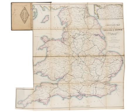
Lot 106
Railways.- Cheffins (Charles F., publisher) Cheffins's Map of the English & Scotch Railways, fourth edition, folding hand-coloured lithographed map, c.710 x 700 mm. including extension to lower left corner, printed advertisement mounted on verso, original cloth with printer's label, hole to spine, [1844] § Dawson (J.E.) & J.Bockett. Macaulay's Metropolitan Railway Map, folding hand-coloured lithographed map, c.440 x 535mm., small stain to title, original cloth, Smith & Ebbs, [1860s], both dissected and mounted on linen, rubbed and faded; and 2 others on railways including a 1905 brochure for the North British Railway, 8vo (4)
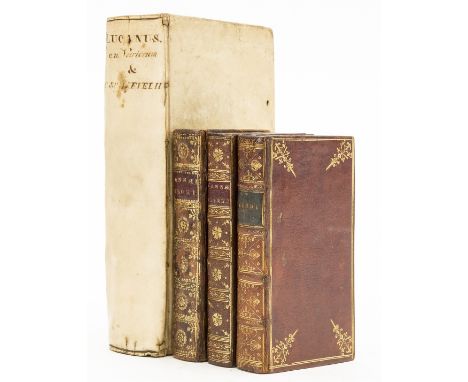
Lot 146
Elzevier.- Florus (Lucius Annaeus) L. Annaeus Florus, Cl. Salmasius addidit Lucium Ampelium. E cod. MS. nunquam antehac editum, engraved pictorial title, woodcut head- and tail-pieces and decorative initials, red ownership stamp 'G. Wills, Esq.' to foot of title, occasional light staining, 18th century red morocco, gilt, spine richly so and with black morocco label, rubbed, [Willems 467], Leiden, House of Elzevier, 1638 § Lucanus (Marcus Annaeus) De Bello Civili, edited by Hugo Grotius, engraved pictorial title and folding map, water-stained, some spotting, contemporary armorial vellum, yapp edges, lacking ties, lightly marked, [Willems 1234], Amsterdam, House of Elzevier. 1658; and 2 others, Elzevier editions of Florus, including a duplicate of first mentioned, v.s. (4)
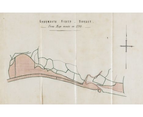
Lot 17
NO RESERVE Dorset, Charmouth.- Charmouth Beach - Dorset. From Map Made in 1783, folding pen and ink with watercolour wash map, 300 x 360mm., n.p., n.d. [c. 1860; and a small quantity of others, manuscripts and printed relating to Charmouth and Lyme Regis, including a pen and watercolour map of the Parish of Charmouth, and manuscript abstract of the title of the Manor of Charmouth etc., v.s., v.d. (sm. qty).
![Holland (Henry) Herwologia Anglica hoc est clarissimorum et doctissimorum. aliqout [sic] Anglorum, 2 vol. in 1, engraved pict](https://cdn.globalauctionplatform.com/ee63881f-2d9b-48be-884b-abd001161691/b8789427-3a6a-4971-bcba-abd001261d1c/468x382.jpg)
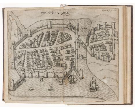
Lot 187
Holland (Henry) Herwologia Anglica hoc est clarissimorum et doctissimorum. aliqout [sic] Anglorum, 2 vol. in 1, engraved pictorial title, incorporating a medallion map of the British Isles and a view of London, half-title to vol.2, 65 engraved portraits by Willem and Magdalena van de Passe and 2 illustrations of monuments to Queen Elizabeth and Prince Henry, woodcut decorative initials and tail-pieces, final contents f., lacking )(5&6, and, as often, the f. of verses signed by I. Gruterus, title just starting to come away at foot and with a couple of repairs verso, the odd marginal tear or repair, some spotting or staining, occasional offsetting, some mostly light browning, contents f. browned, later mottled calf, spine gilt and with red morocco label, [STC 13582; Hind, Engraving in England II, pp. 145-162]. folio, [Arnhem], [Printed by Jan Jansson at the expenses of Crispijn van de Passe and Jan Jansson for Henry Holland, London], 1620.⁂ 'The most trustworthy series of English portraits published up to that time' (Hind).
Lot 189
Ireland.- Stafford (Sir Thomas) Pacata Hibernia, Ireland appeased and reduced: or, an historie of the late vvarres of Ireland, especially within the province of Mounster, under the government of Sir George Carew, Knight, 16 engraved plates only, all but 2 double-page or folding, woodcut head and tail-pieces and decorative initials, lacking Speed's map of Munster and the engraved portraits of The Earl of Totnes and Queen Elizabeth, title soiled, 9 plates trimmed and laid down on thicker paper, small hole within image of plate of army of King of Spain, 2P3 lower corner torn away, affecting printed side-note, final f. laid down, some staining and finger-marking, 19th century calf, spine in compartments, lacking spine label, lower joint split, corners worn, rubbed and scuffed, [STC 23132a], Printed by A[ugustine]. M[athewes]. 1633. And part of the impression made over, to be vented for the benefit of the children of Iohn Mynshew, deceased, 1633; and 2 others, English Literature & History, including a 19th century facsimile edition of the plates from the mentioned work, folio & 8vo (3) sold not subject to return.
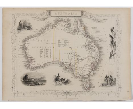
Lot 235
Australia.- Tallis (John) & John Rapkin. Seven maps of Australia, including a general map of Australia, the others of New South Wales, Victoria or Port Phillip, Western Australia, Part of South Australia, Van Diemen's Land or Tasmania, and Polynesia, all with decorative borders and vignette illustrations, engraved maps with contemporary outline hand-colouring, the vignettes uncoloured, each sheet approximately 270 x 365 mm (10 5/8 x 14 1/4 in), some marginal toning, each with binding stitch marks to one edge, some handling creases and light surface dirt, unframed, J. & F. Tallis, [1851] (7)
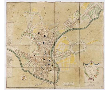
Lot 76
NO RESERVE Bath.- Taylor (A.) & W. Meyler. A New and Accurate Plan of the City of Bath to the present Year, 1801, showing the boundary of the Old City of Bath and the intended construction of Frances Square, with 48-point reference key along the left edge, engraved map by R.Hancock, with hand-colouring, 465 x 525 mm. (18 1/4 x 20 3/4 in), dissected and mounted on linen, small abrasion and minor loss to each corner, surface dirt and rubbing, folding but lacking slipcase, 8vo, January 1st 1801

Lot 78
NO RESERVE Britain.- Cary (John) Cary's Reduction of His Large Map of England and Wales, with Part of Scotland, detailed map of the counties, market towns, roads, post routes and canals, engraving with hand-colouring, 760 x 630 mm (29 7/8 x 24 3/4 in), 'Mail Coach Roads' coloured in red, and 'Stage Coach' routes to London coloured in blue, with additional engraved label key pasted into the English Channel, dissected and mounted on linen, minor surface dirt and light browning, folding with marbled ends, slipcase with publisher's circular printed label to upper cover, rubbed, scuffed and worn, 8vo, 1796 and corrected to the year 1816 § Mogg (Edward) Mogg's New Map of the Roads. A New Travelling Map of England, Wales and Scotland..., map of the England, Wales and part of Scotland, with inset map showing Scotland north of Edinburgh, engraving with hand-colouring, 755 x 620 mm (29 3/4 x 24 1/2 in), dissected and mounted on linen, some surface dirt and toning, splits to linen folds, lacking slipcase, 8vo, 1824; together with Thomas Kitchin's A New Improved Map of Hampshire from the best Surveys and Intelligences, Divided into Hundreds..., engraved map, dissected and mounted in linen, with slipcase, 8vo, [circa 1785] (3)
Lot 79
NO RESERVE Channel Islands.- Guide to the Island of Guernsey (A)...with a Commercial Directory...Alderney, Serk, Herm, and Jethou, 4 lithographed plates, one folding, errata leaf at end, pencil markings, foxing and staining, frontispiece torn and defective at lower margin (laid down), tear to G3 (repaired), Guernsey, J.T.Cochrane, 1826 bound with [Collins (J.E.) The Strangers' Guide to the Island of Jersey, lacking map, Guernsey, 1833, 2 works in 1 vol., contemporary half calf, spine defective § Homelies, ou Sermons de l'Eglise Anglicane..., some staining, contemporary half roan, "Guernesey", T.Dumaresq & J.Mauger, 1817 § Du Frocq (Thomas) Le Nouveau Précepteur..., half-title, list of subscribers and errata at end, contemporary mottled sheep, "Guernesey", H.Bouard, 1818, rubbed or worn; and 8 others relating to the Channel Islands, mostly modern pamphlets (some duplicates), 8vo et infra (13)
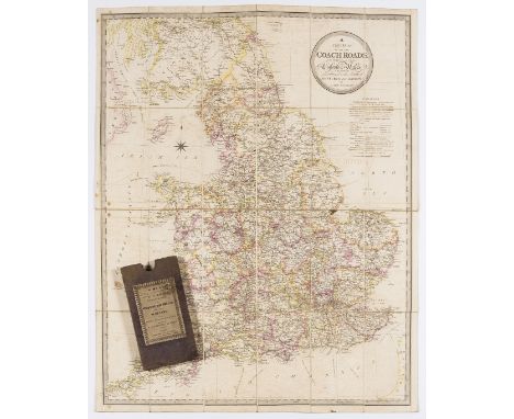
Lot 81
NO RESERVE Coach Roads.- Coltman (Nathaniel) A New Map of all the Coach Roads...of England & Wales..., folding hand-coloured engraved map, c.810 x 665mm., contemporary ink signatures of James Aitken to verso, light offsetting, one or two small ink stains, original cloth slip-case with printer's label, ink inscription to label, R.H.Laurie, 1832; and 2 others on coaching, 8vo (3)
Lot 85
Post Roads.- Cary (John, publisher) Cary's Actual Survey of the Great Post Roads between London and Falmouth...ascertained by A.Arrowsmith Land Surveyor. 1782, engraved throughout with general map frontispiece, vignette title and 50 road strip maps with partial hand-colouring, some light offsetting or soiling, contemporary signature of Wm. Osbaldeston to front free endpaper, modern morocco-backed marbled boards, 12mo, J.Cary, 1784.⁂ Rare; we can trace only 2 copies at auction, one being the Wardington copy in 2007, the other in 2013. Library Hub lists 4 copies (BL, Cambridge, Oxford and National Library of Scotland).
![NO RESERVE Americas.- [Weld (Isaac)] Plan of the City of Washington, Carl Jattnig's reduced version of the 1792 L'Enfant-Elli](https://cdn.globalauctionplatform.com/ee63881f-2d9b-48be-884b-abd001161691/0287643d-ebdc-4dbe-acef-abd001262c4c/468x382.jpg)
Lot 91
NO RESERVE Americas.- [Weld (Isaac)] Plan of the City of Washington, Carl Jattnig's reduced version of the 1792 L'Enfant-Ellicott plan of the city, based on Stockdale's engraving of 1798, engraving on laid paper without watermark, sheet 205 x 245 mm (8 x 9 5/8 in), old folds as issued, some text offsetting from another sheet in the upper right quadrant, unframed, Berlin, [circa 1798-1800]; together with 8 other maps, including Jattnig's A New Map of Upper & Lower Canada, three variant maps of North America by Neele and published by Wilkes, Emanuel Bowen's A New and Accurate Map of Virginia & Maryland, and three of the Caribbean, including Bowen's A New and Accurate Map of the Island of Antigua or Antego, John Hinton's Guadeloupe one of the Caribbee Islands in the West Indies from the latest discovery, and An exact Plan of the City, Fortifications & Harbour of Havana in the Island of Cuba, engravings, various sizes, unframed, 18th century and slightly later (9)
![NO RESERVE Atlantic.- [Bowen (Emanuel)] A New Map or Chart of the Western or Atlantic Ocean, with Part of Europe Africa &](https://cdn.globalauctionplatform.com/ee63881f-2d9b-48be-884b-abd001161691/b2c1868a-92a2-4454-a4da-abd00126adf2/468x382.jpg)
Lot 92
NO RESERVE Atlantic.- [Bowen (Emanuel)] A New Map or Chart of the Western or Atlantic Ocean, with Part of Europe Africa & America: Shewing the Course of the Galleons, Flota &c. to and from the West Indies, map of the Atlantic, illustrating the trade routes between Europe, Africa and America, centred on the Azores, published in The Gentleman's Magazine, engraving on laid paper with small armorial watermark within a circle, sheet 365 x 305 mm (14 1/4 x 12 in), old folds with some splitting, small marginal loss to lower left corner, some offsetting, surface dirt and light browning, unframed, E. Cave, 1740; together with a Plan of Dieppe with New Fortifications, for the Geographical Dictionary, and two others, various sizes, all unframed, 18th century and later (4)

Lot 93
NO RESERVE Caribbean.- Battle of St. Lucia.- Faden (William) Sketch of Part of the Island of Ste. Lucie, map by Lt. G.V. Hart, assistant engineer while in North America, showing the northwestern coast of Saint Lucia, specifically Grande Cul De Sac Bay to Castries, with details of British troops and fleets, and a letterpress extract from General Grant's Letter to Lord Germain printed below the map, engraving and letterpress on laid paper with large watermark of Strasbourg lily, an early state before full letters of GV Hart in lower right, map 405 x 495 mm. (16 x 19 in), sheet 570 x 770 mm. (22 1/2 x 30 1/4 in), full sheet with damp-stains, browning, handling creases and surface dirt, unframed, 1781; together with four other duplicate impressions of the same map, variant states, significant damp-stains, surface dirt, losses to sheets, handling creases, all unframed, 1781 (5)
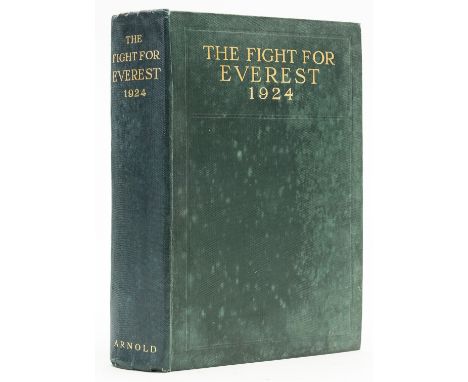
Lot 98
NO RESERVE Mountaineering.- Norton (Lt.-Col. Edward Felix) The Fight for Everest: 1924, first edition, plates, some colour, folding panorama, folding colour map at end, ink inscription to front free endpaper, foxed, original cloth, a little damp-stained, 1925; and another on Lhasa, 8vo (2)⁂ Including a description of the fatal summit attempt by Mallory and Irvine.


-
109198 item(s)/page