We found 109182 price guide item(s) matching your search
There are 109182 lots that match your search criteria. Subscribe now to get instant access to the full price guide service.
Click here to subscribe- List
- Grid
-
109182 item(s)/page


Lot 290
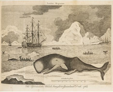
London Magazine (The): and Monthly Chronologer, vol.VIII-X & XXV-XLIV, 23 vol., vol.8-10 with engraved title vignette, the rest engraved frontispieces and vignette titles and woodcut vignette at beginning of each issue, numerous engraved plates and maps, many folding, a few maps hand-coloured (Cuba, North America, Philippines), some a little shaved at fore-edge, occasional spotting or browning but generally clean, hand-coloured map of North America in vol.32 torn with most detached, one leaf in vol.35 torn and repaired, vol.34 with ?additional folding engraved map of Africa loosely inserted (torn and defective, not apparently called for), contemporary half calf (all but vol.8 mottled calf), red roan labels, rubbed, some spine ends a little worn or chipped but a handsome run, 8vo, for T.Astley, 1739-41 & 1756-75; sold as a periodical, not subject to return ⁂ Originally a political magazine founded in 1732 as an alternative to the Tory-based Gentleman's Magazine this also included contemporary events at home and abroad, literary reviews, articles on scientific and medical discoveries, births, marriages, deaths and stock prices. Of particular interest in the present run are the years covering the Seven Years War 1756-63 with many maps and plans of North America (including maps of New York, Pennsylvania, Maryland, Connecticut, Montreal, New Orleans etc., plates of the taking of Quebec and views of New York, Philadelphia and Charleston), as well as Pondicherry, Bengal and the East Indies. There are also several maps of Britain and Ireland, many by Thomas Kitchin, plans of London and campaigns in Europe, plus reports and plates of subjects as diverse as the massacre at Glencoe, the Foundling Hospital, the new Blackfriars bridge, the new state coach of George III, the shadows over Britain during the solar eclipse of 1764, a fire engine, discoveries at Herculaneum, and zoological plates of a sperm whale, elephant, an armadillo and the Beast of Gevaudan in France which was rumoured to have devoured over 80 people.
Lot 99
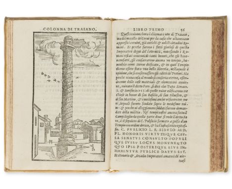
Gamucci (Bernardo) Le Antichita della Citta di Roma, edited by Thomaso Porcacchi, collation: †8 A-Z, Aa8Bb10, second edition, italic type, printer's woodcut device on title and otherwise final blank leaf, woodcut initials, folding map and 38 full-page illustrations, contemporary ink inscription at foot of title, occasional browning, map bound in upside down and with two tears (repaired), hinges split, old engraved book-label on front pastedown, 17th century vellum, yapp edges, red morocco label, a little rubbed and marked, [Adams G204], 8vo, 150 x 100mm., Venice, Giovanni Varisco, 1569. ⁂ Renaissance guide to Rome with charming woodcut views of the antiquities.

Lot 132
London.- Langley (Edward) and Belch (William) Langley & Belch's New Map of London, from Hyde Park to East India Docks in the east, and Vauxhall to Islington, with 24 small vignettes in upper and lower borders, engraved map with hand-colouring, 530 x 795mm. (20 7/8 x 31 1/4 in), dissected and mounted on linen, some pencil annotations, small repaired tears and scuffs, mainly to extremities, otherwise some surface dirt and minor browning, folding into modern red boards, with 12pp New London Guide and reference, [Howgego 256 (2)], 1816. Provenance: Miss Bateman, Chelsea (1914); Presented to Chelsea Public Libraries (bookplate pasted on verso of panel)
Lot 134
London.- Lewis (Samuel) A Plan of London and its Environs, Shewing the Boundaries of the Cities of London and Westminster, showing from Stoke Newington to Dulwich, and from Hammersmith to Greenwich, with some railway lines included, and showing Victoria Park, decoratively lettered title and compass rose upper right, within an ornate border, engraved map by I. Dower, with early hand-colouring, 960 x 1140 mm. (37 3/4 x 44 7/8 in), dissected and mounted on linen, overall light even browning, folding into original red morocco gilt boards, rubbed, spine splitting, worn, [circa 1850].

Lot 13
Bickham (George) The British Monarchy..., engraved throughout with frontispiece after Gravelot, title, 2pp. list of subscribers and 190 numbered leaves on British counties and territories including 2 additional titles (no.39 &164) and a folding table (no.162-3), many with vignettes, maps and illustrations, and an unnumbered folding engraved map, printed on rectos only, some foxing and soiling, no.34 & 106 torn and laid down, several marginal tears or defects, some repaired, contemporary calf, border in gilt and blind, rubbed and stained, rebacked with gilt spine, corners repaired, new endpapers, folio, G.Bickham, 1748. ⁂ The additional titles are: A Description of the several Counties in South Britain, dated 1744, and A Short Description of the American Colonies, dated 1747.
Lot 131
London.- Hunter (Rev. Henry) The History of London, and its Environs, 2 vol. in 3 including volume of maps, first edition in book form, list of subscribers, 28 engraved plates and plans (one aquatint), large folding aquatint panorama & key, 5 folding county maps, folding map of the Thames hand-coloured in outline, large map of environs of London in 4 folding sections and Stockdale's large plan of London in 4 folding sections, some foxing and soiling, plates a little offset, a few ink stains, panorama rather soiled and stained, a little creased and torn at edge and linen-backed, the maps all browned & linen-backed and bound in separate volume, ex-York Subscription Library copy with ink stamp on verso of titles and one or two other leaves, modern half calf, 4to, 1811. ⁂ Complete with the folding panorama & key and Stockdale's plan of London which are often missing.
![Milne (A. A.) [The Christopher Robin books], 4 vol., comprising When We Were Very Young, second issue with roman numerals on](https://cdn.globalauctionplatform.com/dee7acb7-0eba-4924-bdfc-a79000f74b48/51dd191a-973d-450e-ef23-01a69a20a9c2/468x382.jpg)
Lot 471
Milne (A. A.) [The Christopher Robin books], 4 vol., comprising When We Were Very Young, second issue with roman numerals on Contents page, ink ownership inscription and light browning to endpapers, jacket spine chipped and browned, tape repairs to verso, chipping and creasing to extremities, light browning and surface soiling, 1924; Winnie-the-Pooh, map endpapers (a little browned), jacket spine browned, spine ends and corners a little chipped, light rubbing and surface soiling, 1926; Now We Are Six, pictorial endpapers (a little browned), jacket spine a little browned, spine ends and corners a little chipped, light rubbing and surface soiling, 1927; The House at Pooh Corner, pictorial endpapers (a little browned), jacket spine slightly browned, spine ends and corners a little chipped, 1928, first editions, illustrations by Ernest H. Shepard, original pictorial cloth, gilt, dust-jackets, 8vo.
Lot 116
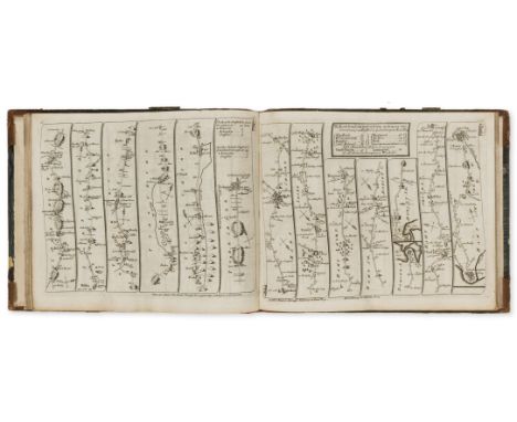
England.- Ogilby (John) and John Senex. The Roads through England Delineated or, Ogilby's Survey, revised by John Senex, engraved calligraphic title, 4 letterpress leaves, engraved general map and 101 strip road maps on 51 leaves, printed on both sides, a little soiled and stained, general map shaved at upper edge, ex-subscription library copy with small ink stamp on title and first leaf of text and label on front pastedown, contemporary half russia, a little worn, rebacked preserving old spine, [Chubb CXL], oblong 8vo, John Bowles, 1757.
Lot 112
British Grand Prix.- Burd & Evans (Chartered Surveyors) Brands Hatch Circuit Ltd., 1964, detailed map of the motor racing circuit and its environs, lithographed map, some outline hand-colouring delineating a perimeter around the track, 1180 x 1175 mm. (46 1/2 x 46 1/4 in), dissected and mounted on linen, folding with marbled board endpapers and manuscript label, 1964. ⁂ The first of the 12 British Grand Prix races that were held at Brands Hatch was in 1964, the last in 1986, and the present map shows the extensions approved by the Kent County Council in 1960. The track was described by Gerhard Berger as "the best circuit in the world".

Lot 249
Sicily.- Geology.- Tata (Domenico) Catalogo di una Raccolta di Pietre Dure native di Sicilia, title with woodcut ornament, woodcut head-pieces, lightly foxed, contemporary Dutch paste-paper wrappers, short split at head of upper joint, a few small stains, rubbed, 8vo, Naples, Raimondi brothers, 1772. ⁂ A rare catalogue of 210 jaspers and agates collected at various sites in Sicily, with each location noted along with a map reference.Tata's reports on volcanic eruptions have become well-known, many of them in the form of letters to the renowned vulcanologist and archaeologist Sir William Hamilton. Tata is also well-known for his pioneering work on meteorites. Provenance: The Feltrineli copy with bookplate; private ownership stamp to foot of title.
![Voyages.- [Henry (David, editor)] An Historical Account of all the Voyages round the World, performed by English Navigators..](https://cdn.globalauctionplatform.com/dee7acb7-0eba-4924-bdfc-a79000f74b48/30ae599f-c45d-4ed8-98a5-ccdef5e6f88e/468x382.jpg)
Lot 160
Voyages.- [Henry (David, editor)] An Historical Account of all the Voyages round the World, performed by English Navigators..., 4 vol., 5 folding engraved maps, 44 engraved plates, list of subscribers, one or two plates shaved or stained, plate of 'Cavendish plunders Paita' in vol.1 with ink stain, folding map in vol.3 laid down, map of 'Icy Sea' in vol.4 torn, for F.Newbery, 1773-74 [vol.1 & 2 1774, vol.3 & 4 1773] [with] [Marra (John)] Journal of the Resolution's Voyage, in 1772, 1773, 1774, and 1775, first edition, folding engraved map, 5 engraved plates, D2 a cancel (as usual), for F.Newbery, 1775 [and] [Rickman (John)] Journal of Captain Cook's last Voyage to the Pacific Ocean, on Discovery; performed in the years 1776, 1777, 1778, 1779, first edition, D4 cancelled as usual, folding engraved map, 5 folding engraved plates, 2 folding, short tear to edge of map, for E.Newbery, 1781, together 6 vol., browning and offsetting, some small spots and stains, a few marginal tears or defects, engraved bookplate of James Perrot, ink signature of Hulbert to front free endpapers of some vol., near uniform contemporary calf, spines gilt with red and blue roan labels, rubbed, small worn patch to upper cover of vol.5, vol.1-4 with spine ends a little worn and joints cracked, 8vo ⁂ Marra's Journal of the Resolution's Voyage was issued as a supplement to Henry's work, intended as vol.5 with Rickman's Journal of Captain Cook's last Voyage to the Pacific Ocean, New Edition [by Henry], 1785, as vol.6. In the present set Rickman's journal has been replaced with the first edition of the work which appeared anonymously before the authorised edition. Rickman (2nd Lieutenant on the Discovery) had managed to smuggle out a copy of his journal instead of handing over all records to the captain as requested. It includes a description of the death of Captain Cook. Marra's work is the first published account of exploration within the Arctic Circle and the earliest authentic account of Cook's second voyage, published eighteen months before the official version. The author was an Irish gunner's mate on the Resolution and accompanied Cook on both his first and second voyages.

Lot 126
London.- Gardner (James) New Plan of the Cities of London & Westminster with the Borough of Southwark, showing from Bayswater to Limehouse, and Kennington Common to Islington, engraved map with hand-colouring, 505 x 755 mm. (19 7/8 x 29 7/8 in), dissected and mounted on linen, some surface dirt, folding into early slipcase, worn, [Howgego 308 (1)], 1827. Provenance: Chelsea Public Library (ink stamp on reverse)

Lot 128
London.- Horwood (Richard) Plan of the Cities of London and Westminster the Borough of Southwark and Parts adjoining Shewing every House, with oval title cartouche in H1, 32 engraved map sheets, joined in 8 vertical strips of 4, each strip approx. 555 x 2,200 mm. (21 7/8 x 87 in), dissected & mounted on linen, occasional minor browning and surface dirt, some repaired tears to extremities, presented loose in later half-morocco portfolio, worn, [Howgego 200 (1)], 1792-99.
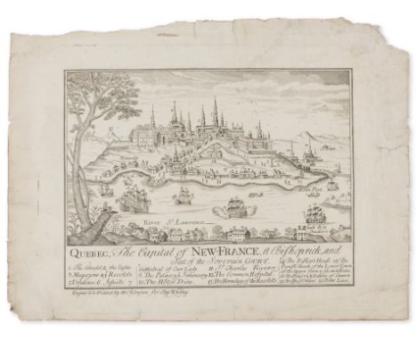
Lot 154
Canada.- Johnston (Thomas) Quebec, The Capital of New-France, a Bishoprick, and Seat of the Soverain Court, engraving, an excellent bold impression, on laid paper with indistinct watermark possibly date '17??', first state before additional lettering, plate mark 212 x 267 mm. (8 3/8 x 10 1/2 in), sheet approx. 240 x 317 mm. (9 1/2 x 12 1/2 in), several repaired nicks and tears with rough edges, one tear going into plate mark upper right, some handling creases, light surface dirt, unframed, [Boston, 1759]. Provenance: Private collection, London Literature: D. McN. Stauffer, American Engravers upon Copper and Steel, 1907, p. 252, no. 1505 I.N. Phelps Stokes and D.C. Haskell, American Historical Prints Early Views of American Cities, etc., 1933, p. 19, no. B-17 G. G. Deak, Picturing America, 1497-1899, 1988, p. 47, no. 78 ⁂ "The most important engraved view of [Quebec], as well as the earliest executed by an American", [G.G. Deak, op. cit., p. 47]. In 1759 Quebec-at the time a French northern settlement-fell to the English following one of the pivotal battles of the Seven Years' War, aptly named The Battle of the Plains of Abraham after the farmer who originally owned the plot. In an effort to capitalise on peaked interest in Quebec, Stephen Whiting, a London-based printseller, commissioned the Boston-based engraver, Thomas Johnston, to produce the present work and 'satisfy the curiosity of American and English audiences about the picturesque city' (G.G. Deak, op. cit., p. 47). Johnston's view is based on another inset view from an earlier map of Quebec by Nicolas de Fer published in 1718, which featured in Chatelain's seven-volume "Atlas Historique" (1705-1720).
Lot 123
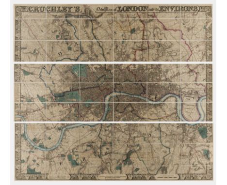
London.- Cruchley (George Frederick) Cruchley's New Plan of London and its Environs Extending Six Miles Round St. Paul's, improved to 1836, showing Hoxton to Walworth and East India Docks to Hammersmith, complete with separately bound General Index, engraved map with decorative border, early hand-colouring, on three horizontal strips, each strip approx. 410 x 1390 mm. (16 1/8 x 54 3/4 in), dissected and mounted on linen, some faint offsetting, otherwise light surface dirt, modern green cloth endpapers folding into modern green cloth slipcase with original publisher's printed label, and with 48pp General Index in limp covers, 8vo, [Howgego 304 C., unrecorded state between (2) and (3)], 1836.


Lot 44
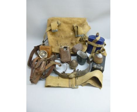
FIRST WORLD WAR MILITARIA COMPRISING A LINEN BACKED MAP DEPICTING THE TRENCH SYSTEMS IN BELGIUM, A CANVAS KITBAG STENCILLED "36874 R GRUNDY, A COY LEATHER UNIFORM STRAPING, CANVAS BELT, BLUE ENAMELLED WATER FLASK WITH CANVAS CARRYING BELT, GREY ENAMELLED CUP "H & C A. - G, 1916", TWO SHELL TOPS, SHRAPNEL DAMAGED ORILUX OFFICER'S SIGNAL AND READING LIGHT IN A LEATHER CASE, GERMAN LEATHER BELT WITH A "GOTT MIT UNS" BUCKLE AND OTHER ITEMS


Lot 579
An impressive early 20th Century walnut map or plan chestOf split construction with a rectangular top above four long drawers each with a pair of brass loop handles and centred with a rectangular brass card holder frame stamped GR, the lower section similarly with four long drawers and raised on a plinth base, 126x92x90cm.
Lot 19
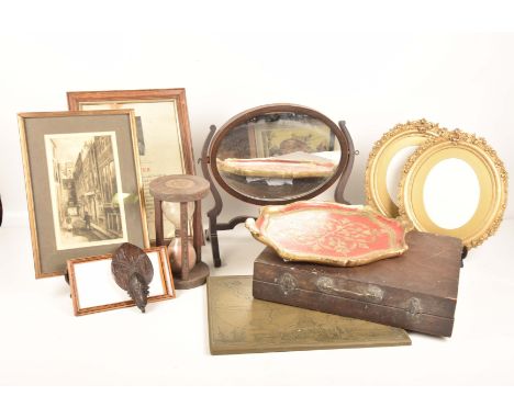
A pair of late 19th Century oval gilt wood picture framesEach with a leaf and fruit moulded frame along with a gilt embellished papier mache tray, a 19th Century oval toilet mirror, after Walter Richards black and white engraving, framed religious verse, a composition tablet, world map, an artists box and an oak framed egg timer.


![[Railway] An Official Railway Map of Scotland, dated 1960 with wooden hanging posts, a London & North Eastern Railway and Con](https://cdn.globalauctionplatform.com/0a797a13-352e-4786-9d16-a7a20096c93a/32df60ed-8ab2-4b7a-fa86-91be6225c5dc/468x382.jpg)
Lot 393
[Railway] An Official Railway Map of Scotland, dated 1960 with wooden hanging posts, a London & North Eastern Railway and Connecting Railways poster, sundry diagrams, and a 2008 Train Timetable poster, together with three vintage 'One-Inch Ordinance Survey Map' advertising posters for Scottish towns with applied 'You Are Here' stickers highlighting stations


Lot 232
AFTER J CROSS "Cross's New Plan of London. 1836", sectional map, mounted on canvas, 64.5 cm x 100 cm CONDITION REPORTS Unknown if stuck down, there are areas of wear to the canvas backing, some small pinholes. There is some wear to the edges of each map section and in some areas the corners are bent over. Discolouration etc throughout, general wear and tear conducive with age and use, frame has knocks, bumps etc - see images for more details


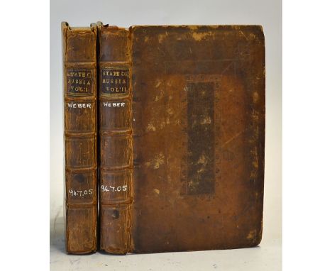
Lot 242
Russia - The Present State Of Russia by Christian Friedrich Weber. London: W. Taylor. 1722. Two volumes, first English edition, 352 & 432 pages. Giving an interesting account regarding Russia during the time of Peter the Great stated on title page thus; "An Account of the Government of that Country, both Civil and Ecclesiastical, of the CZAR's Forces by Sea and Land, the Regulation of his Finances, the several Method she made use of to civilize his People and improve the Country" etc. large folding engraved map, large folding plan of St. Petersburg, some spotting and soiling, contemporary panelled calf, 8vo, Each size 5" × 8", an early book about Russia

Lot 259
New Zealand - An Account Of New Zealand by William Yate, 1835 a 310 page book plus Index and 10 plates and Map. Extensively detailing the Maori native inhabitations, their culture customs way of life etc. At this time there were only a small number of missionaries and the odd explorer there as the country was not opened for colonization until the mid-1840s. In original green cloth board binding. A very early book for New Zealand
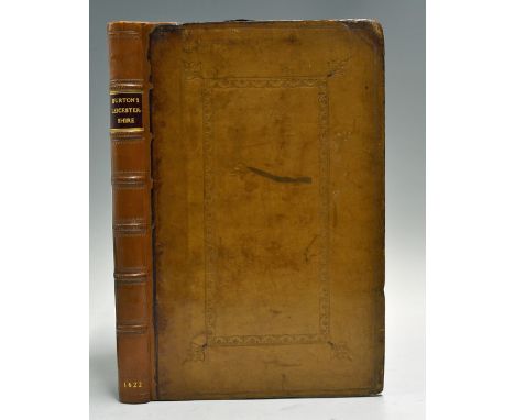
Lot 250
1622 The Description of Leicestershire Book containing Matters of Antiquity, History, Armorye and Genealogy, written by William Burton. London: John White first Edition. Folio, engraved title, engraved portrait frontispiece, folding map by C. Saxton, coats-of-arms in text, 330 pages as called for including index, eighteenth century panelled calf, a little light spotting, professionally re-backed, corners repaired. Size 20 x 30cm approx. (William Burton (24 August 1575 - 6 April 1645) was an English antiquarian, best known as the author of the Description of Leicester Shire (1622). On 29 September 1591 he entered Brasenose College, Oxford (B.A. 22 June 1594). He was admitted, on 20 May 1593, to the Inner Temple. He was one of a group of antiquaries there, including Sir John Ferne, Thomas Gainsford, and Peter Manwood. His county history, the Description of Leicester Shire, was begun by 1597. It appeared in print in October 1622, dedicated to George Villiers, Marquess of Buckingham. It was one of the earliest county histories of that time).


Lot 584
India Through the Sikh War c1890 G. A. Henty an in depth account into the Sikh Wars 1845 and 1849. Chapters include Moodkee, Ferozeshah, Aliwal, Sobraon, and Gujerat. Also has a map of the Punjab and 12 illustrations including an interview with Sher Singh and many more. 384 pages, in good condition.
Lot 468
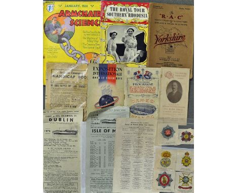
Assorted Publication Selection to include1909 Royal Visit to Birmingham University Programme, The Royal Tour of Southern Rhodesia, The RAC County Road Map & Gazetteer of England & Wales, 1931 Armchair Science, 1948 Sporting Chronicle Handicap Book, 1937 Exposition International Arts et Techniques, plus other ephemera, worth inspecting (10)
Lot 277
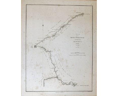
China Map 1793 Sketch of the Pay-Ho or White River and of the road from PEKIN to GEHO taken 1793, engraved by B. Baker, published 12th April 17965 by George Nicol, 'An Authentic Account of An Embassy from the King of Great Britain to the Emperor of China', mounted on card, perfect for framing, overall size 52 x 62cm, with minor stains, but still clear

Lot 533
WWII K3 North Africa H2 Spain Double Sided Rayon Map entitled North Africa containing Morocco, Algeria, Tunisia, Italian Libya and Spanish Rio De Oro scale 1: 6,000,000, the reverse numbered H2 covering Spain, Sardinia and the northern coast of Africa, scale 1:3,000,000, measures 47 x 58cm approx.

Lot 257
Egypt & Ottoman Empire - My Wanderings Being Travels In The East - by John Gadsby 1858 an extensive 594 page book plus Index, foldout Map and many illustrations in the text. Giving a lot of detail regarding the authors travel in Greece, The Ottoman Empire, Constantinople, Smyrna travel in Southern Turkey, Egypt, Slaves, travel down the Nile and across the Sinai Desert of Jerusalem, the Bedouin Arabs etc etc. In original Cloth binding with tooled leather spine. One page illustrated
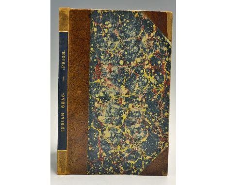
Lot 251
A fine scarce Boys own adventure of the Napoleonic Wars 'Narrative of a Voyage in The Indian Seas in the Nisus Frigate during the years 1810 and 1811 Book by James Prior, first edition 1819. 112 page book, folding engraved map frontis showing Indian Ocean, Africa, the routes; plan of that coast of Isle of France; plan of landing of British army in Mapou Bay at the Isle of France; engraved view of Cape of Good Hope, later marble board with gold tooled leather spine. The ship was commanded by Captain Philip Beaver. Much of the work describes the British attack on the Isle of France (Mauritius), The ship then took Seychelles for Britain and involved in the capture of Java. (Prior was born at Lisburn Ireland in 1790. He entered the navy as a surgeon, served aboard the "Nisus. Later was at the surrender of Helgoland in 1814, he was on the coast of La Vendée, and present at the surrender of Napoleon on 15 July. Later became staff surgeon to the Chatham division of the Royal Marines, & to three of the royal yachts, became Deputy-Inspector of Hospitals in 1843, was knighted in 1858), in good clean condition

Lot 326
Unique Margaret Thatcher Signed Falklands Surrender Documents from 1982 - facsimile documents from the original documents counter-signed by Margaret Thatcher and General Sir Jeremy Moore Commander of the British Forces during the conflict, alongside these signed documents is The Falklands Islands Map signed by Sir Rex Hunt, Civil Commissioner for the Falkland Islands at the time, includes the Instrument of Surrender to the Commander of all Argentine Land from and signed by Major General J. Moore, a further Instrument of Surrender with regards specifically to Argentinian forces occupying South Georgia, signed to the bottom by Margaret Thatcher, the third a document in Spanish issued on HMS Endurance also signed by Margaret Thatcher, all items are framed and glazed, measuring 45 x 55cm and the map framed and glazed measures 72 x 60cm, these are the original copies counter-signed by Margaret Thatcher in original ink and Sir Jeremy Moore. A rare opportunity to purchase documents that are not available to the public. The original surrender documents are in The Archives at Whitehall and will remain there indefinitely secured by the UK Government (4)
Lot 133
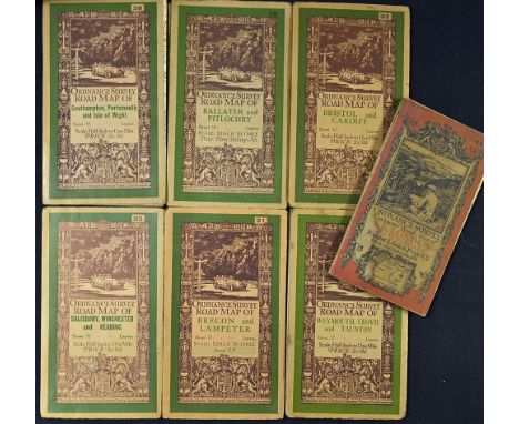
Early 20th Century Ordnance Survey Map Selection to include Brecon and Lampeter, Salisbury, Winchester and Reading, Weymouth, Yeovil and Taunton, Bristol and Cardiff, Ballater and Pitlochry, Southampton, Portsmouth and Isle of Wight and S.E. London and Sevenoaks, some wear throughout, worth inspecting (7)
Lot 244
1831 Inland Navigation and Railways of Great Britain Book by Joseph Priestley a comprehensive account regarding each canal then existing in Britain, its company formation, the shares issued, its construction, any extensions and running etc. A 702 page book, plus 8 pages of index. Also fold out map and a handcoloured elevation plan. The most complete guide to the British canal system of the early 19th century and a most useful reference book. In green cloth board binding with original laid on top

Lot 265
1784 Voyage Dans Les Parties Intérieures de l'Amérique Septentrionale, Pendant les années 1766, 1767 & 1768 Book by Jonathan Carver [Travel In The Inner Parts of North America during the years 1766, 1767 & 1768] in French language translated from the English edition, Paris, Pissot, 451p, complete with fold out map, bound in calf leather, gold gilt decorated spine, hinge appears used and fragile, pages are in good, clean condition, overall a nice example

Lot 618
India - Punjab - Map British Occupied Sikh States With Kashmir Under Gulab Singh C1850s a large rare German map showing the Sikh state of Punjab under British rule after the Anglo Sikh wars. Also shows at the time Gulab Singh Dogras newly acquired Kashmir State which was brought with nanakshah rupees stolen from the Sikhs. Hand coloured. Excellent condition.

Lot 241
Australia - The Land Of Gold "The Narrative Of A Journey Through The West Australian Goldfields In The Autumn Of 1895" by Julius M Price. Published 1896. A very interesting 204 page book with 20 full page illustrations and over 40 illustrations within the text, plus map. Extensively detailing his travels and adventures in the very early days of the Western Australian Gold Rush. With index listing some 30 established mines. In pictorial board covers in Gold and Black.

Lot 252
1830 An Accurate Description of the Liverpool and Manchester Railway Book by James Scott Walker, (The year of its opening). A historic and interesting 52 page book with one plate illustrating the railway in Manchester, also with fold out map and trains on Sankey Viaduct above this map. Detailing the establishing, construction of the line, stations etc. design of Locomotives and Passenger Carriages. Also giving an interesting account of the Grand Opening of the Railway. This book dedicated by the author to George Stevenson Esq., the Engineer. Attractively rebound in Marble Boards with cloth spine and gold tooled title, in good clean condition
![WWII German Publication 'Der Lohn Der Tat' - [The rewards of the action] magazine, c.1944 intending to familiarize German you](https://cdn.globalauctionplatform.com/e1eec8ff-0220-4068-b6d5-a78c010283ba/de21d5c5-2afb-4beb-a2fc-618b92a1c25d/468x382.jpg)
Lot 570
WWII German Publication 'Der Lohn Der Tat' - [The rewards of the action] magazine, c.1944 intending to familiarize German youth with the wards available to soldiers for outstanding bravery and service, together with Europa?isches Russland Map 1941, with tears present, speckled foxing, A condition (2)
-
109182 item(s)/page