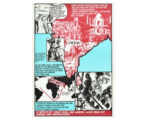
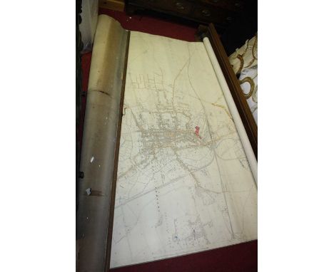
We found 109198 price guide item(s) matching your search

Refine your search

Year

Filter by Price Range
  • List
  • Grid
  • 109198 item(s)
    /page

Lot 119

Thomas Walsh, after Robert William Mylne - 'Geological Map of London and its Environs, Section from Hendon to East Wickham', engraving in 10 sections with period hand-colouring, folding and backed onto linen, published by Edward Stanford 1858, overall 41.5cm x 67.5cm, within cloth covered boards with gilt title.This lot is subject to a Buyer’s Premium of 24.5% (including VAT @ 0%) of the hammer price. Purchased online via the-saleroom.com, this lot will attract an additional premium of 5% (including VAT @ 0%) of the hammer price.

Lot 125

James Wyld (publisher) - 'A Map of Scotland Drawn Chiefly from the Topographical Surveys of Mr. John Ainslie and from those of the Late General Roy &c. & c.', engraving in 54 sections hand-coloured in outline, folding and backed onto linen, published by Wyld circa 1840, overall 117.5cm x 100.5cm, within a cloth covered cardboard case with original paper label.This lot is subject to a Buyer’s Premium of 24.5% (including VAT @ 0%) of the hammer price. Purchased online via the-saleroom.com, this lot will attract an additional premium of 5% (including VAT @ 0%) of the hammer price.

Lot 126

John Andrews - 'Andrews's New and Accurate Map of the Country Thirty Miles Round London…', engraving with hand-colouring in 24 sections, folding and backed onto linen, third edition published by James Heskett, London 1813, overall 70.5cm x 65cm, within a cloth covered cardboard case with original paper label.This lot is subject to a Buyer’s Premium of 24.5% (including VAT @ 0%) of the hammer price. Purchased online via the-saleroom.com, this lot will attract an additional premium of 5% (including VAT @ 0%) of the hammer price.

Lot 69

C. & J. Greenwood - 'Map of the County of Sussex', engraving with later hand-colouring in outline, published 1829, 58.5cm x 70cm, within a gilt frame.Buyer’s Premium 29.4% (including VAT @ 20%) of the hammer price. Lots purchased online via the-saleroom.com will attract an additional premium of 6% (including VAT @ 20%) of the hammer price.

Lot 2480

A MILITARY CAMPAIGN STYLE NEST OF THREE WORLD MAP TABLES

Lot 286

A German Kriegsmarine 3rd E-Boat Flotilla Squadron plaque (Schnellboot Plakette). constructed of aluminium with multi-coloured enamels, with a map of Europe overlaid by an E-Boat and a palm tree, topped by a Kriegsmarine-style national eagle, with an Iron cross at the bottom, unmarked to the reverse, 15.6cm high, 10.2cm wide It is believed that these plaques were produced by the commander of the 3rd Flotilla as a commemorative for men who served in the unit during the campaign in the Mediterranean.

Lot 288

A German Second World War Army Officer's map case, brown leather, indistinctly stamped 'E8'(?) and named.

Lot 345

A German Second World War Army armshield, in bronzed zinc with an eagle and swastika on a shield bearing the dates 1941/42 together with a map of the Crimea, on original green cloth backing. Sold together with a certificate of award to Leutnant Pöschel Fritz, 13. Kp.1 Gr. Rgt. 437 (13 Kompanie, 1 Battalion Grenadier-Regiment 437), dated 16.12.42. This certificate is (facsimle) signed by Generalfeldmarshall Erich von Manstein who was Commander of the 11th Army and oversaw the invasion of the Crimean peninsular. Notes: Grenadier-Regiment 437 was attached to the 132nd Infantry Division. In November 1941, the division advanced on Crimea and later took part in the Siege of Sevastopol, being one of the first to break through the city's defences. By September of 1942, the division had transferred to Leningrad followed by further fighting in Latvia and the Eastern Front. This division was reduced to two regiments in November 1944, before being wiped out during action in the Courland Pocket after being cut off from the remainder of German troops and ultimately surrendering to the Red Army. Sold together with original paperwork of purchase from MilitariaPlaza.NL.

Lot 504

EUROPEAN SCHOOL, 19TH CENTURYA trompe-l'oeil of a sketch, letters and other papers lying on top of a map watercolour and ink 35 x 47.5cm

Lot 116

Militaria - Major McCollum ' 88378 ' of Ireland, Medical Core, WWI effects including a wooden bound leather steamer trunk with period red Cross painted front panel; another steamer trunk of period painted with McCollum; a military pistol brace / belt strap; leather shin guards; buttons; conical formed leather ordnance survey map case, etc

Lot 102

A mixed lot of collectables, including four antique keys, two other keys, three smoking pipes, a papier mache egg, a folding draughts set, a wallet, a glove stretcher, a set of hand painted cards, a bone box and a box with a map, a carved wooden sculpture of a man, and a paper mache box IMPORTANT! REGARDING CONDITION REPORTS: Please note this is an auction with items being sold of behalf of The Alexander Devine Children's Hospice. Whilst we appreciate you would like to receive condition reports we may not have time to do this for you so please try and come and view the items in person as we may not be able to supply you with further information and photographs

Lot 42

After Alice Tait : Map of London and Map of New York, a pair of colour prints, each 39 cm x 49 cm, framed. (2)

Lot 76

A box of Sheaffer pens, further pens including Parker, pocket compass/map measurer, pair of cufflinks and smart phone ring hook

Lot 162

WW2 RAF- Suitcase containing the personal effects of Flight Sergeant (Navigator) A.J Airey 1594307. To include three aircraft identification posters and cards, elementary flying training textbook, folding map of Europe with annotations i.e. flight path etc

Lot 163

WW2 RAF- Double sided silk escape / survey map of Burma & China scale 1:1,000,000. Property of Flight Sergeant (Navigator) A.J Airey 1594307.

Lot 206

Official Railway Map Of Scotland 1941. 

Lot 2099

WWII War Dept map of Duisburg, first edition dated 1944. (sheet 37). P&P Group 1 (£14+VAT for the first lot and £1+VAT for subsequent lots)

Lot 2115

DDAC WWII German Nazi map of Europe, these were often used by the Wehracht, France and Dunkirk dated. P&P Group 1 (£14+VAT for the first lot and £1+VAT for subsequent lots)

Lot 364

Raden (Woldemar) Switzerland, Its Mountains and Valleys, folio, illus. by A. Closs, 1878; Gos (Charles) Voyageurs Illustres en Suisse, lge. 4to, cloth, illus., French text, A. Berne, Paris, 1937, bearing the blindstamp of The Alpine Club; and Heim (Dr. A.) Das Santisgebirge: Geological Map of Switzerland, Vol. 2, atlas, illus. with maps and diagrams, lge. 8vo, original printed boards, Berne. (3)

Lot 395

Walcott (Mackenzie E.C.) A Guide to the Coasts of Durham and Northumberland, 16mo, original boards, illus. with fold-out map, 1861: John Murray's A Handbook for Travellers in Durham and Northumberland, 16mo, half-calf, illus. with map, 1873; and four other Guides to Durham, Northumberland and Carlisle. (6)

Lot 429

A collection of Ordnance Survey Maps and other Tourist Maps/Guides, including: Ordnance Survey Tourist Map of the Trossachs in Loch Lomond; Hexham and The Wall Country, by Fred Tait; A Guide To The Roman Wall, by R.G. Collingwood; A Corbridge Roman Station Northumberland Official Guide; Hadrian's Wall, by F.G. Simpson; and others, in one box.

Lot 128

ISAAC BASIRE, A LATE 18TH CENTURY HAND COLOURED MAP OF 'NEAR EAST THE KINGDOMS OF ARMENIA, PONTUS, CAPPADOCIA, MEDIA & C', 8.5" x 12.5" (21 x31cm).

Lot 308

A frosted art glass bowl on stand with ‘face’ pattern to base together with an Iitalla map ash tray designed by Tapio Wirkkala, a bohemian iron and spatter pattern glass shade oil lamp, Tom Philabaum art glass perfume bottle together with other pieces of etched Scandinavian glass and art glass**CONDITION REPORT**PLEASE NOTE:- Prospective buyers are strongly advised to examine personally any goods in which they are interested BEFORE the auction takes place. Whilst every care is taken in the accuracy of condition reports, Gorringes provide no other guarantee to the buyer other than in relation to forgeries. Many items are of an age or nature which precludes their being in perfect condition and some descriptions in the catalogue or given by way of condition report make reference to damage and/or restoration. We provide this information for guidance only and will not be held responsible for oversights concerning defects or restoration, nor does a reference to a particular defect imply the absence of any others. Prospective purchasers must accept these reports as genuine efforts by Gorringes or must take other steps to verify condition of lots. If you are unable to open the image file attached to this report, please let us know as soon as possible and we will re-send your images on a separate e-mail. 

Lot 653

Jan Jansson, coloured engraving, Map of Suthsexia vernacule Sussex, Spanish text verso, 39 x 53cm**CONDITION REPORT**PLEASE NOTE:- Prospective buyers are strongly advised to examine personally any goods in which they are interested BEFORE the auction takes place. Whilst every care is taken in the accuracy of condition reports, Gorringes provide no other guarantee to the buyer other than in relation to forgeries. Many items are of an age or nature which precludes their being in perfect condition and some descriptions in the catalogue or given by way of condition report make reference to damage and/or restoration. We provide this information for guidance only and will not be held responsible for oversights concerning defects or restoration, nor does a reference to a particular defect imply the absence of any others. Prospective purchasers must accept these reports as genuine efforts by Gorringes or must take other steps to verify condition of lots. If you are unable to open the image file attached to this report, please let us know as soon as possible and we will re-send your images on a separate e-mail. 

Lot 655

John Speede, coloured engraving, Map of Cambridgeshire, 1676 issue, English text verso, 39 x 53.5cm**CONDITION REPORT**PLEASE NOTE:- Prospective buyers are strongly advised to examine personally any goods in which they are interested BEFORE the auction takes place. Whilst every care is taken in the accuracy of condition reports, Gorringes provide no other guarantee to the buyer other than in relation to forgeries. Many items are of an age or nature which precludes their being in perfect condition and some descriptions in the catalogue or given by way of condition report make reference to damage and/or restoration. We provide this information for guidance only and will not be held responsible for oversights concerning defects or restoration, nor does a reference to a particular defect imply the absence of any others. Prospective purchasers must accept these reports as genuine efforts by Gorringes or must take other steps to verify condition of lots. If you are unable to open the image file attached to this report, please let us know as soon as possible and we will re-send your images on a separate e-mail. 

Lot 659

Michael Cadman (1920-2012), a folio of assorted watercolours, mostly France, many signed and dated, largest 42 x 60cm, a box of the artist's sketch books and a map of Surrey.**CONDITION REPORT**Thirty-six total, not including the framed 18th century map of ‘Surry’ . Generally fair; many detail the location, France, Spain, Chichester Cathedral, jockeys and racehorses, etc.PLEASE NOTE:- Prospective buyers are strongly advised to examine personally any goods in which they are interested BEFORE the auction takes place. Whilst every care is taken in the accuracy of condition reports, Gorringes provide no other guarantee to the buyer other than in relation to forgeries. Many items are of an age or nature which precludes their being in perfect condition and some descriptions in the catalogue or given by way of condition report make reference to damage and/or restoration. We provide this information for guidance only and will not be held responsible for oversights concerning defects or restoration, nor does a reference to a particular defect imply the absence of any others. Prospective purchasers must accept these reports as genuine efforts by Gorringes or must take other steps to verify condition of lots. If you are unable to open the image file attached to this report, please let us know as soon as possible and we will re-send your images on a separate e-mail. 

Lot 673

Kip after Saxton, coloured reprint, Map of Cornwall 1576, 37 x 50cm**CONDITION REPORT**PLEASE NOTE:- Prospective buyers are strongly advised to examine personally any goods in which they are interested BEFORE the auction takes place. Whilst every care is taken in the accuracy of condition reports, Gorringes provide no other guarantee to the buyer other than in relation to forgeries. Many items are of an age or nature which precludes their being in perfect condition and some descriptions in the catalogue or given by way of condition report make reference to damage and/or restoration. We provide this information for guidance only and will not be held responsible for oversights concerning defects or restoration, nor does a reference to a particular defect imply the absence of any others. Prospective purchasers must accept these reports as genuine efforts by Gorringes or must take other steps to verify condition of lots. If you are unable to open the image file attached to this report, please let us know as soon as possible and we will re-send your images on a separate e-mail. 

Lot 706

Georg Braun and Frans Hogenberg, coloured engraving, Map of Marseilles, from 'Civitates Orbis Terrarum', c.1572, latin text verso, overall 38 x 52cm**CONDITION REPORT**PLEASE NOTE:- Prospective buyers are strongly advised to examine personally any goods in which they are interested BEFORE the auction takes place. Whilst every care is taken in the accuracy of condition reports, Gorringes provide no other guarantee to the buyer other than in relation to forgeries. Many items are of an age or nature which precludes their being in perfect condition and some descriptions in the catalogue or given by way of condition report make reference to damage and/or restoration. We provide this information for guidance only and will not be held responsible for oversights concerning defects or restoration, nor does a reference to a particular defect imply the absence of any others. Prospective purchasers must accept these reports as genuine efforts by Gorringes or must take other steps to verify condition of lots. If you are unable to open the image file attached to this report, please let us know as soon as possible and we will re-send your images on a separate e-mail. 

Lot 538

PICTURES AND PRINTS ETC, to include framed Arthur Rackham illustrations, signed E. H Barlow etching of a cathedral interior, topographical print of Westminster Abbey, Joshua Archer map of Wiltshire, Thomas Condor maps 'A New Map of Oxfordshire' and 'A New Map of Buckinghamshire' published by Alexander Hogg, J. W Ludlow print of poultry, watercolour depicting 'The Swan of Iver' by Ralph Shaw, Sorrento marquetry picture etc

Lot 336

C. G. C. Dickson & Dr. D. M. Kroon (Eds.)Johannesburg: A. D. Donker, 19784to (18,7 x 21,3 x 4,9cm) 670pp. Special quarter-leather hardcover binding, with blue boards. 5 raised bands. Gilt lettering to spine. With 198 fine full-colour plates of the various species of butterflies, fold-out map of Southern Africa at rear of book, and fold-out list of subscribers and collectors at front of book. With fixed lint bookmark as issued.Limited edition of 300 copies, of which this is no. 74 (Subscriber’s copy)Condition: Very good. Light rubbing and slight stains to the boards. Slight soiling and slight wear to rear board. Light scuff marks, superficial war and shelfwear to the spine. One small crease to the side of rear fold-out map. Text and plates are clean and bright, and copy is solidly bound.

Lot 512

A 19th Century hand coloured map print 'A modern map of Sussex' by J Ellis

Lot 551

A map print Todi de L'Etat de L'Eglise, an etching Italian lake views and a print The Cathedral of Orvietos

Lot 161

Exploring Switzerland, a large tourist Map, 48" x 30" approx

Lot 17

Walnut framed large early Map of Ethiopia, a chart of Ethiopic or Southern Ocean, published by W Faden Charing Cross July 1st 1808 engraved by John Roper, Map measures 35-Inches x 22.5-Inches

Lot 171

Original antique map of Peru - Description of the islands of the Estuaries / Descriptio insularum Aestiuarurum from Mercator/Hondius Atlas Minor. This hand coloured map details regions and natural landmarks such as mountains, rivers and lakes. Title appears in an ornate illustrated frame as well as a blue and red decorative compass. The reverse side has a description of the islands of the estuaries written in Latin. Good condition, staining, creasing, small tears, paper loss on bottom right corner, browning, double sided. Country of issue: Netherlands, designer: Mercator Hondius, size (cm): 22x28, year of printing: 1635.

Lot 178

Original antique illustrated map of Boston - The plan is drawn and engraved by J. Rapkin and the illustrations are drawn and engraved by J. Watkins. Illustrations featuring boats in Boston harbour, state house and Bunkers Hill Monument. Issued by John Tallis and Company London and New York. Good condition, creasing, staining, tape on reverse. Country of issue: UK, designer: J Rapkin, J. Watkins, size (cm): 27x37, year of printing: 1851.

Lot 188

Original vintage travel map - The Authentic Map of London with index of streets places of interest, bus, trolleybus & tram routes, railway stations & London Transport Underground Stations all clearly shown in Red. House numbering along the principal thoroughfares. Published by Geographers' Map Co., Ltd., London. Produced by Alexander Cross. Good condition, folds, creasing, staining, tears, paper skimming Country of issue: UK, designer: Alexander Gross, size (cm): Folded 21x12 Unfolded 59x88, year of printing: 1920s.

Lot 193

Original vintage travel poster for Expedition Citroen Centre-Asie 3eme Mission G.-M. Haardt - L. Audouin-Dubreuil / Citroen Central Asia Expedition 3rd Mission G.-M. Haardt - L. Audouin-Dubreuil, featuring a map of Middle East, Central Asia and the Orient, with a red line marking the mission itinerary, red dotted line marking variants or itineraries that are subject to change, profile of the route of the expedition from Beirut to Beijing marking the length of the expedition in kilometres and the height of the mountains in metres, with a note Races and religions - Persia: Very diverse races: Parsis and Guebres, worshipers of fire; Tajiks, often blond or brown with blue eyes, descendants of Iranians (Iran plateau). Afghanistan: Population of very mixed races. The Afghans count for half of it; Tajiks number about 1,000,000, mostly farmers; the Usbeks are of Turcoman origin; trade, finance, are mainly practiced by immigrant Hindus. Islamism dominates there. China: 30 to 50,000,000 Muslims (Islamism is the most widespread of the unofficial religions there). A few tens of thousand Catholics. The rest of the population is Buddhist, Taoist and Confucianist. Horizontal. Printed by Colouma-Publicite, Argenteuil. Good condition, folds, tears, creasing, small paper loss on left edge Country of issue: France, designer: Unknown, size (cm): 40x55, year of printing: 1931.

Lot 198

Original vintage travel poster showing illustrated map of Northern Switzerland – La Suisse Septentrionale – Swiss Tourism Board Country: Switzerland. Year: 1939. Artist: Otto M. Muller. Size (cm): 54x36 Very good condition, faint creases.

Lot 199

Original vintage travel poster showing illustrated map of French Switzerland – La Suisse Romande – Swiss Tourism Board Country: Switzerland. Year: 1939. Artist: Otto M. Muller. Size (cm): 54x36 Very good condition, minor defects in top margin.

Lot 211

Original vintage poster Daily Telegraph World Map. Specially drawn for the Daily Telegraph by Geographia. Published by Hutchinson and Co LTD London and Melbourne. Horizontal. Good condition, folds, creasing, small tears on edges, staining. Country of issue: UK, designer: Unknown, size (cm): 76x101, year of printing: 1940s.

Lot 212

Original vintage travel poster for Birchington - At all Seasons the fine dry air is invigorating beyond any other on our coasts - featuring an illustration with holidaymakers on the beach by the sea wall with white clouds in the blue sky above, with an inset marking Birchington on the map. Printed by Cooper the Printer Ltd., Margate. Fair condition, tears, creasing, paper loss in bottom right corner. Country of issue: UK, designer: D.W. Burley, size (cm): 76x51, year of printing: 1940s.

Lot 220

Original vintage illustrated map poster of Turkey including the surrounding areas of the USSR, Iran, Iraq, Syria, Bulgaria, Greece, the Black sea and the Mediterranean Sea. Illustrations on the pictorial map include factories, industries, foods, drink, animals, crops, boats, planes and other significant points of interest. Blue monochrome photographs of landscapes, factories and architecture appear in the corners of the poster. Bold red lettering appears alongside the national flag above. Issued by the information office. Good condition, creasing, small tears, pinholes, minor staining. Country of issue: USA, designer: Liam Dunne, size (cm): 56x87, year of printing: 1950.

Lot 230

Original vintage travel poster with Midi - Mediterranean - Bassin Aquitain map, marking Bordeaux, Toulouse, Limoges, La Rochell, ANgouleme, Perigueux, Pau, and Tarbes, as well as Charente, Dordogne, Garonne, and Adour rivers. The reverse of the poster features Midi Mediterranean map marking Perpignan, Beziers, Montpellier, Nimes, Arles, Avignon, Aix, Marseille, Toulon, Cannes, Nice, and Corsican Ajaccio, and Bastian, with Aude, Tarn, Gard, Rhone, Golo rivers, with legend marking elevation, basins, ports, industrial or commercial cities, canals, railways and hydroelectric lines. Very good condition, minor staining, double sided. Country of issue: France, designer: Unknown, size (cm): 75x90, year of printing: 1950s.

Lot 236

Original vintage travel poster for Arizona Vacation State of the Nation featuring an illustrated map of Arizona marking routes and towns and showing various sports and activities including horse riding, nature watching, skiing, sailing, golf, sunbathing, camping and fishing as well as trees, cactus plants, animals and famous landmarks including the Grand Canyon National Park, Monument Valley, Window Rock Navajo, Mormon Temple, Joshua Forest and Hoover Dam with a stylised sun above the title text. Printed by Neblo publications. Fair condition, large restored paper losses, backed on linen. Country of issue: USA, designer: Unknown, size (cm): 92x62, year of printing: 1960s.

Lot 259

Original travel poster featuring Transport for London Tube map marking Bakerloo, Central, Circle, District, Hammersmith & City, Jubilee, Metropolitan, Northern, Piccadilly, Victoria, Waterloo & City, DLR, London Overground lines, with an advertising for Ikea below. Published by Transport for London. This diagram is an evolution of the original design conceived in 1931 by Harry Beck. Horizontal. Good condition, folds, creasing, small tears, minor staining. Country of issue: UK, designer: Unknown, size (cm): 101x126, year of printing: 2009.

Lot 314

Original vintage Civil Defence Corps recruitment poster - People with executive ability are needed. Join the Headquarters Section. Civil Defence Corps. Ask at your Council Offices. Issued by H.M. Government. - featuring an illustration of a gentleman in a uniform set over red background, and images of ladies at their desks talking on the telephone, gentleman pinpointing the locations on a map, a man in uniform transmitting locations on the radio. The Civil Defence Corps (CDC) was established in 1949 in Great Britain, the purpose of the organisation was to mobilise and take control over major national emergencies, such as nuclear attack, flood, earthquake, invasion, civil disorder, the organisation existed until 1968. Good condition, small tears, creasing, minor staining. Country of issue: UK, designer: Unknown, size (cm): 37x25, year of printing: 1950s.

Lot 352

Original vintage poster one of the series of twelve posters depicting historical events and describing the basis for the development of Western economic power. The poster depicts and describes how European merchants wanted gold and silver as money for expanding their trade, running shot of gold and silver in the 1400s, Spanish and Portuguese merchants sent people on voyages of exploration, as a result millions of Aztec, Inca and Maya Indians were killed by the Europeans, many more died in the mines as slaves from starvation or from European diseases. The poster features illustrations of Indian artefacts, European merchants, slaves, set over yellow map background. Published by Poster-Film Collective, London. Printed by London Caledonian Press. Excellent condition, minor creasing, laminated. Country of issue: UK, designer: Unknown, size (cm): 72x52, year of printing: 1979.

Lot 355

Original vintage poster India, one of the series of twelve posters depicting historical events and describing the basis for the development of Western economic power. The poster depicts and describes how British conquered India, in the early 1800s the British broke up the Indian cloth industry so that cloth made in England could be sold in India, fine cotton and silk cloth was sent to Europe, the British began to use Indian land and workers to grow food and raw materials cheaply (such as tea and jute) to send to Britain. So Britain got cheap goods and workers, while India got hunger and unemployment. The poster features illustrations of Taj Mahal, tea plantation, a map with arrows marking the movement of goods. Published by Poster-Film Collective, London. Excellent condition, minor creasing, laminated. Country of issue: UK, designer: Unknown, size (cm): 72x52, year of printing: 1979.

Lot 384

Original vintage World War Two poster Daily Telegraph War Map of the Mediterranean and Northern Africa, with British Possessions and Mandates, French territories, and Italian possessions, marking railways, roads, canals, tracks, oilfields, naval bases, steamer routes, demilitarised zones demanded under Armistice Terms, June 1940 thus. Drawn for the Daily Telegraph by Geographia. Published by Hutchinson and Co LTD London and Melbourne. Horizontal. Good condition, folds, creasing, small tears on edges, staining. Country of issue: UK, designer: Unknown, size (cm): 76x101, year of printing: 1940s.

Lot 390

Original vintage propaganda poster depicting World War Two Allied Air Offensive against Germany up to January 1st 1941. The poster features an aerial bombing map of Northern Germany with an enlarged inset of The Ruhr. The Key features information on Munition Works Power Stations / Aerodromes or Seaplane Bases / Aircraft Works / Oil / Railways / Docks & Waterways / German Navy / More than one type of objective bombed. The text in Key reads - Figures show number of major attacks on each area up to January 1st, 1941 Minor bombing raids, leaflet and reconnaissance sorties are not included. - The map was published as a reassurance to the English public that Royal Air Force was striking back at Germany during The Blitz - a German bombing campaign against the UK in 1940 and 1941. Printed for H.M. Stationery Office by J. Weiner, Ltd. London, UK. Fair condition, restored tears, folds, tears, paper loss on image, browning on margins, pin holes. Country of issue: UK, designer: Unknown, size (cm): 76x50.5, year of printing: 1940.

Lot 395

Original vintage World War Two poster Daily Telegraph War Map of the Russian Front, marking United Kingdom and British Empire, countries in British Military Occupation, Soviet Russia (Union of Soviet Socialist Republics), Germany, Countries in German Military Occupation, Italy and Italian Empire, Finland, Vichy France and French Empire, Neutral Countries, oil fields, oil pipe lines, naval bases, railways, canals, shipping routes. Horizontal. Good condition, folds, creasing, small tears on edges, staining. Country of issue: UK, designer: Unknown, size (cm): 76x101, year of printing: 1941.

Lot 48

Original vintage fruit crate label poster for Panama brand lemons and oranges grown in the USA by California Red Ball and packed by Johnston Fruit Co. in Santa Barbara, California - Design features a bunch of lemons next to a map of Panama and the United States of America with delivery routes drawn to Seattle, Portland, San Francisco, Santa Barbara, Los Angeles, Galveston, New Orleans and New York. Horizontal. Excellent condition. Country of issue: USA, designer: Unknown, size (cm): 23x31, year of printing: 1930s.

Lot 77

Original vintage advertising poster for Valdespino Jerez featuring a map of the Jerez - Xeres - Sherry producing district, issued by The Origin Denomination Control Commission, marking proper land for vineyards with chalky soils and clays & sands, and producing zones - Carrascal - Olorosos, Macharnudo - Amontillados, Anina, Balbaina, Los Tercios - Finos and the Pedro Ximenez Sherry, Sanlucar, Mirafloers, Torrebreba - Manzanillas, Chipiona, Rota, Madronales - Muscatels, Sweets, Tehigo - Tintilla (Rota Tent), Colour Wine. Fair condition, several tears, several paper losses, staining, creasing. Country of issue: Spain, designer: F. Sancho, A. Munoz, size (cm): 62x49, year of printing: 1950s.

Lot 299

CHRISTOPHER SAXTON, a 17th century map of Huntingdon, framed and glazed. 35 x 28.5 cm.

Lot 729

An East Bergholt Suffolk map by John French, framed and glazed. 47.5 x 43.5 cm.

Lot 1115

One box of pictures and prints to include map of Suffolk, various prints etc

Lot 1141

A large linen-backed 1920s map of Bury St Edmunds and the surrounding areas, printed and published by The Director General at the Ordnance Survey Office, Southampton, 1926 (some tears to paper and basic repairs), housed on wall mounted roller fixing

Lot 730

Assorted items including a Bakelite tape measure and a cigarette case with part map of Africa

Lot 201

A 18th century later hand coloured map of Jerusalem surrounded by vignettes of Jewish religious activity sold by Richard Ware in slender gilt frame and glazed 35cm x 42cm (image size)

Loading...Loading...
  • 109198 item(s)
    /page

Recently Viewed Lots