We found 109198 price guide item(s) matching your search

Refine your search

Year

Filter by Price Range
  • List
  • Grid
  • 109198 item(s)
    /page

Lot 974

Early 19th Century Period Map of Lancashire, Published by T. L. Murray, 19 Adam Street, Adelphi, May 1st 1830. This Is An Original Map of 1830 - Not a Copy. Mounted and Framed Behind Glass.

Lot 608

"CARY'S TRAVELLERS COMPANION, OR A DELINEATION OF THE TURNPIKE ROADS OF ENGLAND AND WALES …", printed for John Cary, Engraver, London 1817, including a folding map of England, Wales and part of Scotland (12 sheets on linen), rebound with original boards, 7.25" x 5"

Lot 610

CHRISTOPHER SAXTON: "DORCESTRIAE, COMITATUS VICINARUMQUE REGIONUM NOVA VERAQUE DESCRIPTIO ANNO.DM 1575", 15.75" x 21.75". See illustration. This map is illustrated on page 12 and to the front cover of Beaton's Dorset Maps.

Lot 611

"GERARD MERCATOR" CORNUBIA, DEVONIA, SOMERSETUS … " A map of South Wales and South West England, with decorative title by Mercator for his "Mercator Projection" map of the world, circa 1580, 14.5" x 18.25"

Lot 612

WILLIAM KIP FOR CAMDEN'S BRITANNIA, 1607 "DORCESTRIAE COMITATUS VULGO DORSETT …", with description to the reverse, 11" x 15.25". This map is illustrated on page 16 of Beaton's Dorset Maps.

Lot 613

JOHN SPEED: "DORSETSHYRE WITH THE SHYRE TOWNE … ANNO 1610", with inset map of the County Town, with description to the reverse, 15.5" x 20.25". This map is illustrated on page 19 of Beaton's Dorset Maps

Lot 614

MICHAEL DRAYTON: A MAP OF DORSET SHERE, HAMP SHERE AND THE ILE OF WYGHT, for Drayton's Series of Poems "Polly-Albion", 1612", 10.5" x 13". See illustration. This map is illustrated on page 21 of Beaton's Dorset Maps.

Lot 615

JOHN BILL: "DORSETSHIRE" A map of the county from the abridgement of Camden's Britannia, 1627 (unframed), 5.75" x 7.5". This map is illustrated on page 22 of Beaton's Dorset Maps.

Lot 617

WILLIAM WEB: "DORCESTRIAE COMITATUS VICINARUMQUE … ANNO DN. 1642" A revised edition of Saxton's map, the "Civil War Issue". 15.5" x 21". See illustration

Lot 618

JOAN BLAEU: "COMITATUS DORCESTRIA …" 1645 from the Atlas Novus, a New Atlas for the British Isles, 16" x 20", with description to the reverse. This map is illustrated on page 26 of Beaton's Dorset Maps. See illustration

Lot 619

JAN JANSSON: "COMITATUS DORCESTRIA" A hand coloured map published in the French edition of Atlas Novus, 1650, unframed, 19.5" x 23". This map is illustrated on pg 27 of Beaton's Dorset Maps. See illustration

Lot 620

ROBERT MORDEN: "DORSET SH", The Seven of Diamonds from William Redmayne's pack of playing cards of 1676, 3.75" x 2.25". This map is illustrated on pg 32 of Beaton's Dorset Maps.

Lot 622

ROBERT MORDEN: "DORSET SHIRE" The hand-coloured map sold by Able Swale … 1695 The First Time Morden's Map was included in Camden's Britannia, 15" x 16.75". This map is illustrated on pg 35 of Beaton's Dorset Maps.

Lot 623

JOHN SENEX: "THE ROAD FROM LONDON TO THE LANDS-END IN CORNWALL" printed on both sides of a page, 6.5" x 8.5" (unframed) and a map of the county by Jacob Van Langeren, 1657, with mileage chart, 7" x 5" (2). The second example is illustrated on page 25 of Beaton's Dorset Maps.

Lot 625

OWEN & BOWEN: "BRITANNIA DEPICTA" (pages 153 and 154) "The Road from Bristol to Weymouth", 7.5" x 5". This map is illustrated on page 38 of Beaton's Dorset Maps.

Lot 626

HERMANN MOLL: "DORSET SHIRE" 1724 from a new description of England and Wales" with illustrations of antiquities to the margins, 8.5" x 12.75". This map is illustrated on pg 39 of Beaton's Dorset Maps.

Lot 627

THOMAS BADESLADE & WILLIAM TOMS: "A MAP OF DORSET SHIRE", 1742, 6.25" x 6.25", an unframed map of the county by J. Cowley, 1744, and a county map by Emmanuel Bowen 1759 (3). The first two are illustrated on pgs 42 & 43 of Beaton's Dorset Maps

Lot 628

GEORGE BICKHAM: "A MAP OF DORSET SHIRE WEST FROM LONDON" inscribed to Yeo of Shaftesbury, Lord Lieutenant of the County, a landscape map circa 1754 with two pages of descriptions, 14.5" x 9.25" (unframed). See illustration. This map is illustrated on pg 51 of Beaton's Dorset Maps.

Lot 629

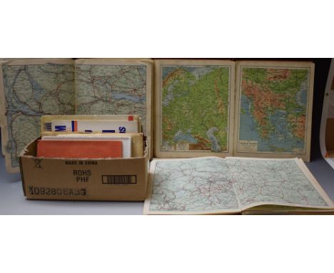
JOHN ROCQUE: "DORSET-SHIRE" from "The Small British Atlas", published from 1753-1769, 6.5" x 7.75", Francis Grose's Map of the County, 8.5" x 6.25", and Thomas Conder's 1784 map of the county from Walpole's New & Complete British Traveller (unframed), 4.25" x 7" (3). These maps are illustrated on pages 49, 34 and 61 of Beaton's Dorset Maps.

Lot 630

THOMAS KITCHIN & EMMANUEL BOWEN: "AN ACCURATE MAP OF DORSET SHIRE …" from R. Martin's The English Atlas", 1794, 17" x 21". This map is illustrated on pg 47 of Beaton's Dorset Maps

Lot 631

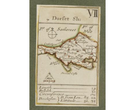
JOHN CARY: "DORSETSHIRE" 1792 from a New Pocket Atlas and Geography of England and Wales, 6" x 4", John Luffman's 1803 Small Circular Map of the County, 6.25" x 4", and Henry Teesdale's County Map from the New British Atlas, 1829 (unframed), 15" x 19" (3). The first and second maps are illustrated on pgs. 62 and 73 of Beaton's Dorset Maps

Lot 632

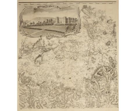
ISAAC TAYLOR: "DORSET SHIRE to the Right Hon. Lord Lieutenant … 1765", a large-scale folding map of the county with vignettes of Maiden Castle, Lulworth Castle and other landmarks, printed on six sheets, each unmounted, each sheet 23.75" x 22.75". See illustration. This remarkable map is probably the first large-scale survey of the county produced as a direct result of the Society of Arts advert of 1759 offering the sum of £100 to any person who shall make an accurate survey of any county on the scale of one inch to one mile. Beaton suggests that fewer than 200 copies will have been produced originally and "only a few are known to be in existence". See illustrations on pages 52-55.

Lot 633

WALLIS AND REID: "A MAP OF THE COUNTY", 1820, 2.75" x 4.5", Aristide Michel Perrot, a decorative map of the county from "L'Angleterre ou Description Historique a Topographique …1823", 4.75" x 3.5", a similar uncoloured example, and a map by Charles Smith, 1822 (4), all unframed. The second of these illustrated on pg. 80 of Beaton's Dorset Maps

Lot 634

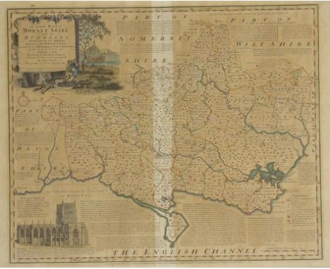
JAMES PIGOT: "A MAP OF THE COUNTY" from "The British Atlas of the Counties of England" 1841, 4.5" x 6.5" (unframed), Reuben Ramble's Map of the County surrounded by illustrations of local agriculture and industry, Samuel Lewis's map from the topographical dictionary of England, 1845, and Thomas Moule's Map of the County from Barclays Dictionary 1850 (4). Three of these are illustrated on pages 88, 89 and 92 of Beaton's Dorset Maps.

Lot 636

JOHN SPEED: "WILSHIRE" A map of the County with detail of Salisbury and Stonehenge, with description to the reverse, 15" x 20". See illustration

Lot 638

JOHN HARRISON: "A MAP OF MIDDLESEX: ENGRAVED FROM AN ACTUAL SURVEY WITH IMPROVEMENTS" from Maps of the English Counties 1781, 14.5" x 18.5"

Lot 639

"A TOPOGRAPHICAL MAP OF THE COUNTY OF SUSSEX" by W. Gardner and the Late T. Yeakell, published by W. Faden, June 4th 1795, 32 panels mounted on linen, 31" x 39.5" (unframed)

Lot 640

A GEOGRAPHICAL AND STATISTICAL MAP OF SCOTLAND FROM LAVOISNE'S GENEALOGICAL, HISTORICAL, CHRONOLOGICAL AND GEOGRAPHICAL ATLAS, revised 1828, 18.5" x 23" (unframed), a map of the Isle of Thanet, a map of Mont Blanc published 1954, and a folded map of Nepal (4)

Lot 642

ROBERT MORDEN: "A HAND COLOURED MAP OF THE COUNTY OF DORSET SHIRE" from "Camden's Britannia 1695", published by Abel Swale Awensham & John Churchil, 14.5" x 17.5"

Lot 647

THOMAS MOULE: "DORSETSHIRE" A hand-coloured map with a vignette of Shaftesbury, 8.5" x 10"

Lot 670

"PLANO DE LA RADA DE ANGRA ... 1788" A hand-coloured map of a section of coastline, unframed, 24.75" x 37.25", and a collection of other similar maps (6)

Lot 671

"A MAP OF SOUTH AMERICA CONTAINING TIERRA FIRMA, GUAYANA ...FROM MR D'ANVILLE WITH SEVERAL IMPROVEMENTS ... LONDON 1779", printed on two sheets, each 21.25" x 47.5" (2) (unframed)

Lot 674

"SOUTHERN PART OF ABERDEEN AND BANFF-SHRS." published by John Thomas, Edinburgh 1826, 21" x 27", and a similar map from the same publication depicting parts of Aberdeenshire (2)

Lot 675

JOHN ARROWSMITH: "THE LONDON ATLAS", 1842. "The London Atlas of Universal Geography, Exhibiting the Physical & Political Divisions of the Various Countries of the World, constructed from Original Materials. Is most respectfully dedicated to his venerable friend John Middleton Esqr. As a Testimony of gratitude and esteem by his much obliged & humble servant. John Arrowsmith, F.R.G.S & R.A.S. 10 Soho Square, London. Published by J.Arrowsmith 10 Soho Square 1842." Containing 50 maps with hand coloured details and borders. Rebound with leather spine, corners and title. The volume 22.25" x 15". Mounted in a Rosewood veneered metamorphic table and stand. The table with a rectangular top with a moulded border resting on a square column with recessed panelled sides, and on a quadriform base with turned feet and recessed castors. The rectangular top opening along its' length to reveal the Atlas in a fitted compartment. The entire top tilting ona pivot with adjustable bolt, the top folding and sliding to support the atlas when open. With a concealed slide below. 29" high x 25" wide x 18.5" deep. PROVENANCE Private collection West Dorset NOTE John Arrowsmith was a member of one of the most important London based families of map makers, eventually taking over the running of the family business and publishing the highly regarded London Atlas. The set of maps in this volume were amongst the best available at the time being compiled from the most up to date information and presented in a pleasing clear manner, the atlas is generally regarded as the first 'modern' Atlas of the Victorian period. A founder member of the Royal Geographical Society he was awarded their gold medal in 1863. This atlas has remained in the same family collection for much of the 20th century. In a remarkable metamorphic library table which was surely commissioned to house the Atlas in a fine gentleman's library, this is one of the most interesting pieces of Victorian Library furniture to have come to the market in many years.

Lot 759

MAJOR DENHAM, CAPTAIN CLAPPERTON AND THE LATE DR. OUDNEY: "Narrative of Travels and Discoveries in Northern and Central Africa", printed by John Murray, 1826; N. D. Anvers "Heroes of North African Discovery", printed by Marcus Ward & Co., 1877; Mungo Park "The Journal of a Mission to the Interior of Africa in the year 1805", printed for John Murray by W. Bulmer & Co., 1815, with a pull-out map and in a tooled leather binding (3)

Lot 795

THOMAS PHILIPOTT: "Villare Cantianum or Kent Surveyed and Illustrated", first edition, 1659 (no map), printed by William Godbid, London

Lot 853

THOMAS HARDY (1840-1928) "The Mayor of Casterbridge", "The Wessex Novels, Vol.III", with an etching by H. MacBeth-Raeburn, and a map of Wessex, printed by Osgood, McIlvaine & Co., 45 Albemarle Street, London 1895, hand inscribed in ink on end papers "To Miss Jean Rosamond Ffooks on her marriage from Mr and Mrs Thomas Hardy, October 1921" Provenance: The vendor's great-aunt's father, E.A. Ffooks was a prominent member of Dorchester Society and was in charge of the Dorset County Council at its' inception, with a staff of six. This is how they came to know the Hardy family.

Lot 255

Interesting collection of 1962 British Lions Rugby tour Maps, Itinerary, and Players Statistics - issued by The Technical Map Services, Johannesburg by kind permission of SARFB - some completed plus 2x Western Mail Newspaper covering the British Lions Tours of 1971 and 1974 (11)

Lot 447A

1962 Gt Britain Rugby League tour to Australia and New Zealand official R.F.L correspondence to players incl 8x page printed document to incl player's agreement ( weekly pay 60/- plus payments to their wives and children while away on tour amounting to nearly £4 10sh per week, and a bonus at the end of the tour from match profits, programme of matches, travelling arrangements, Hotels, map showing the venues and much more

Lot 77

Bahamas, Silver 50 Dollars 1996, commemorating 'Third Millennium Year 2000,' 120mm, 2000g (64.3 troy oz) of .999 silver, rev. world map in shape of a conch shell; with cert, in wooden CofI, matt finish, UNC

Lot 5361

Maps - A Horlick's Malted Milk advertising motorists' map of Scotland; others including Newnes Motorists Touring Maps and Gazetteer, Michelin Guide 1900 reprint, ordnance survey, etc

Lot 245

A silver and blue enamelled cigarette case, engraved map of Michigan on reverse, 6 2/3" high, 7.5oz troy approx

Lot 373

A framed silk escape map of France printed on a silk handkerchief, given to Major Charles Farrell MC before the D-Day landings, 24" x 22"

Lot 413

Visit to Portsmouth, May, 1907. Visit of Colonial Premiers and the Houses of Parliament to Portsmouth, privately printed for publication, time table, text pages of key areas visited, fold-out map of dockyard and Whale Island, fold-out list of ships of home fleet at Portsmouth 1907, seven tissue guarded real photographs of submarines, the 'Dreadnought', etc., bound in full dark-blue calf leather, richly decorated in gilt, silk endpapers, all edges gilt, 19.5cm x 13cm (1)

Lot 425

A canvas map case, a WW2 helmet and a water bottle, together with a folding wooden and canvas campaign chair.

Lot 397

Map size approx 24.5 x 20cm.

Lot 845

Victorian and later letters and invoices, WWI postcards, map of the GWR system, Japanese book of poetry and sundry ephemera.

Lot 826

A late 17th century John Norden map of Sussex, 'Augmented by John Speede' English text verso, 39.5cm by 51cm

Lot 931

Local interest, a 19th century map of the Isle of Wight engraved by B Baker, 18cm by 22.5cm, together with a map of Portsmouth, 20cm by 25cm, and a plan of Portsmouth, 31cm by 20cm

Lot 639

A Chinese shaped rectangular porcelain dish decorated with stylized map and character symbols, on circular foot, marks to base, 32.5cm diameter, together with five assorted blue and white plates including one with decorative symbols

Lot 312

A framed map of the local Gloucester area featuring the GWR railway, roads etc. including Stroud, Dursley, Cirencester etc. marked to lower left corner 'made by Herry Perry finished on the feast of St John at the Latin Gate 1930', Perry designed Art Deco posters and maps for the London Underground circa 1928 to 1937, 34x31cm

Lot 216

Twenty five 18thC maps including road map examples

Lot 310

Collection of ephemera to include circa 1922 photograph album Richmond Park, Rome etc London District railway map on cloth and Chambers Guide to Sussex

Lot 294

Four plans /maps relating to the Gloucester Lunatic Asylum (Horton Road) comprising a 1902 map of the area, a site plan inscribed J C Cooke, Clerk of Works, May 6th 1889, a further drawing with J C Cooke's signature and Secretary of State stamp, and 1900 Gloucester boundaries map (largest 73cm x 104cm)

Lot 217

Framed Cruchley's county map of Gloucester showing railways, stations, roads etc. circa 1880, 58x50cm

Lot 315

A 1939 linen backed road map of India

Lot 127

A Welsh clasp Bible rebound in full leather, 1st January 1819. The Bible dates from the mid to late 18th century and still retains its map of Israel and the surrounding area. Teithlau Plant Israel Yn Yr Anialwch. Rhodd Rhis.t. Morys Est LICC, i'r Cymry

Lot 138

METAL MICHELIN MAP OF UK GARAGE SIGN AND POLLING STATION SIGN

Lot 468

After John Norden. 'SUSSEXIA', a 17th century hand-coloured engraved map of Sussex by William Kip, 23 x 39.5cm, 'DEVONIAE' also by Kip, 'DORSET SHIRE' by Robert Morden, 'CORNWALL from the BEST SUREVYS 1748', 'ENGLAND & WALES with the Islands of Garnsey, Jersey & C.' by Herman Moll, a road map of Salisbury and Southampton, all framed and glazed, together with three unframed maps 'THE INVASIONS OF ENGLAND AND IRELAND' by John Speed, 'BRITANNIA Saxonica' and 'NORTHUMBIAE Comitatus olim sedes OTADINORUM'. (9)

Loading...Loading...
  • 109198 item(s)
    /page

Recently Viewed Lots