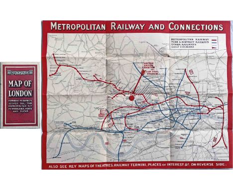
We found 109198 price guide item(s) matching your search

Refine your search

Year

Filter by Price Range
  • List
  • Grid
  • 109198 item(s)
    /page

Lot 280

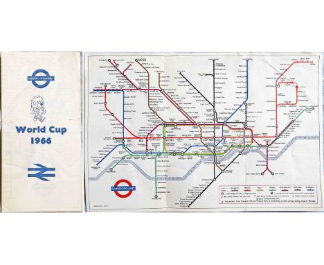
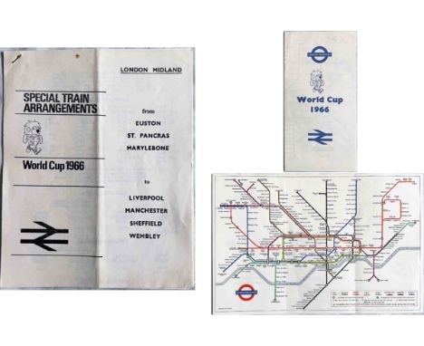
Pair of 1966 football World Cup items, both featuring 'World Cup Willie' on the covers and comprising a special, paper edition of the London Underground POCKET MAP designed by Paul Garbutt and with small maps on the reverse for getting to Wembley and White City stadia, plus a 6-page LEAFLET issued by British Railways, London Midland Region with times of trains from their London terminals to Liverpool, Manchester, Sheffield & Wembley, including special services on match days. The first is in excellent condition, the second is very good with light wear/tiny stains. [2]

Lot 137

Selection (6) of railway CARRIAGE DIAGRAMS etc comprising British Railways 1993 Intercity, modern era GNER ''Principal Rail Routes of Britain' (both laminated board), 1992-93 Network SouthEast network map and 'London Connections', 1993 'Kent Networker' (all thin card) plus c1980s BR(S) '1066 Country' (vinyl). All in good to very good condition. [6]

Lot 339

1927 'General' (LGOC) POSTER MAP of motor bus routes. These were pasted at bus shelters, Underground stations etc. A most uncommon survivor from this early era. Measures 34" x 26" (87cm x 66cm). Edge scuffs and nicks but otherwise in good condition. Folded. [1]

Lot 128

1933 London Underground H C Beck diagrammatic, card POCKET MAP from the first-year series titled 'Underground Railways of London'. Issued c.September 1933 and has print reference 33-2791. Shows the escalator connection between Bank and Monument stations. An excellent example, crisp and firm. [1]

Lot 145

1933 London Underground H C Beck diagrammatic, card POCKET MAP from the first-year series titled 'Underground Railways of London'. This is the edition with no print-code, issued c. August 1933 and has 'LPTB' inside the bullseye logos. Refers to re-naming of Dover St station to Green Park and the merger of Holborn and British Museum stations, all in September that year. Light creasing at one corner, otherwise in very good condition. [1]

Lot 249

1933 MAP of the area under the control of the new LPTB (London Transport) showing the boundaries of the London and Metropolitan Traffic Areas, Metropolitan Police District, roads available to the Board without and with restriction, roads available to Outside Proprietors, Underground and Metropolitan Railways and other railways. Boundaries of other Traffic Areas have been added by hand. Linen-backed inside card covers, opens out to 23" x 28" (59cm x 71cm) and is in very good condition, a little wear to the cover with two names added. [1]

Lot 104

c1902 Central London Railway fold-out POCKET MAP produced to promote its service from Bank to Shepherds Bush. The line is superimposed in red on a street-map background and shows the generating station and depôt at the western end with an inset plan of the subways at Bank at the top right. The reverse has travel and ticket information etc. An excellent copy with only very minor blemishes. [1]

Lot 296

1913 London Underground POCKET MAP 'What to See & How to See it. Stations everywhere' with print-code 487-150M-1.6.13. Opens out to 14 " x 11" (36cm x 28cm). Shows projected extensions to Ealing Broadway, Queens Park and Edgware as well as the LNWR line to Watford in anticipation of the proposed Bakerloo extension. Cover has one of the first printed 'bar & circle' logos, possibly the first such. An excellent example in very good condition indeed with no significant blemishes other than (the first?) owner's name on the cover. [1]

Lot 229

1932 London Underground 'Guide to the New Underground Service' to/from Arnos Grove etc POCKET BOOKLET with card covers dated Sept 1932 and containing a fold-out Underground map of Central London. Most unusually, this comes with the matching pair of complimentary RETURN TICKETS (unused) in their original envelope for use to/from Piccadilly on the opening day of the new service - 19 September 1932. In very good condition, the ticket envelope has a little damage at one corner. [2]

Lot 388

c1932 Metropolitan Railway POCKET MAP, the Met's version of the London Underground map, with its own lines in red and the rest of the system in light blue. This is the green-cover issue with print-code M.1495/100M (no other codes), undated but circa 1932 and shows the Stanmore branch & Piccadilly Line to Cockfosters under construction. Generally in very good, lightly-used condition with light wear. [1]

Lot 473

1937 London Transport quad-royal POSTER MAP of Green Line Coach and Country Bus Routes. These would have been posted on bus shelters, at bus and Underground stations etc. Includes Underground and main-line railways and shows almost the whole LT operating area: Baldock to the north, Horsham to the south, High Wycombe to the west and Tilbury to the east. In excellent condition with only very minor blemishes, the best example of this map that we have seen. Folded. [1]

Lot 18

1925 London Underground MAP of the Electric Railways of London "What to see and how to travel", Summer 1925 edition. Shows the British Empire Exhibition site and nearest stations with red dots. An excellent example with only very minor blemishes. [1]

Lot 389

c1924 Metropolitan Railway POCKET MAP, the Met's version of the London Underground map, with its own lines in red and the rest of the system in blue. This is the dark red-cover issue with print-code G.1608/100,000 (no other codes) and is the version with the overprint at Wembley Park for the British Empire Exhibition and Cup Final Stadium. In very good, lightly-used condition. [1]

Lot 448

1946 London Transport quad-royal POSTER MAP of Green Line Coach Routes. Depicts the now fully-reinstated post-WW2 network, reflecting the return to peacetime standards. A couple of tiny puncture holes, a little weak at one fold-cross but otherwise in very good condition. Folded. [1]

Lot 52

c1931 London Underground linen-card POCKET MAP from the Stingemore-designed series of 1925-32. This is a special edition produced for the London Terminal Coach Station with an overprinted box pointing to Oval Station. A well-used example with wear and stains. [1]

Lot 331

Pair of 1920s Metropolitan Railway thick-card CARRIAGE MAPS from compartment stock comprising "Metropolitan Railway and Connections" and "Map of Extension Lines into Metro-Land". Both are in ex-carriage condition, well-used with damps stains, small losses, cracks etc. [2]

Lot 347

1933 first edition of the H.C. Beck London Underground diagrammatic, card POCKET MAP with the famous cover slogan "A new design for an old map....." and print-code 750M - 1-33. In good, lightly-used condition with small signs of wear and small stains. [1]

Lot 16

1924 London Underground POCKET MAP of the Electric Railways of London "What to see and how to travel". Winter 1924/25 (November 1924) edition. Generally in very good condition, a couple of small stains in the cover. [1]

Lot 9

Selection (5) of misc RAILWAY FLYERS, POSTER, MAP etc comprising Cleobury Mortimer & Ditton Priors Light Railway 'Offences & Penalties' (undated, several inward tears), 1891 & 1894 Flyers for Oxen & Sheep sales at GWR Aynho and Heyford stations (good condition), GWR pillow envelope with hiring charge (very good condition) and 1894 Airey's RCH Railway Map of London and its Suburbs (unfolded, canvas-backed, reasonable, used condition. [5]

Lot 248

c1908/9 London Underground MAP in Simpson's North-West London guidebook. The map is the official, unified issue and one of the first to carry the new UndergrounD logo. It opens out to 14" x 11" (37cm x 29cm), is in near-mint condition and could be carefully removed from the guidebook if so wished. The guidebook is in good condition with some cover wear. [1]

Lot 404

1937 London Underground Metropolitan Line CAR DIAGRAM (map) for compartment stock showing all the branches from Aldgate. The lines are coloured green and the early LT bullseye is featured. Print-code: 37-4309-3,000. Printed on thick card, size: 24.5" x 8.5" (62cm x 21cm). Folded once vertically and a little stained from use but generally in good condition. [1]

Lot 364

1925 London Underground linen-card POCKET MAP from the Stingemore-designed series of 1925-32. This is the first issue, dated 11.5.25, with red cover, in the the smaller-size of the first sub-series, and shows the extensions of the Hampstead & Highgate/CSLR Railway from Charing Cross to Kennington and from Clapham Common to Morden as under construction and also highlights the Wembley Exhibition Grounds. An excellent example in very good condition - crisp, firm and unmarked. [1]

Lot 53

c1928/9 London Underground linen-card POCKET MAP from the Stingemore-designed series of 1925-32. This is one of the two first issues of the larger, second series and is the one with the yellow cover. These were issued before any of the early 1930s line extensions were projected. A very good example, crisp and firm, with just very light use. [1]

Lot 117

c1926 Metropolitan Railway POCKET MAP, the Met's version of the London Underground map, with its own lines in red and the rest of the system in blue. This is the blue-cover issue with print-code G.3285/50.M (no other codes), undated but circa 1926. Generally in very good, lightly-used condition with a couple of very small partings at the fold corners. [1]

Lot 36

1922 London Underground MAP of the Electric Railways of London "What to see & how to travel". Designed by MacDonald Gill with station names in his distinctive style of calligraphy, this is the issue dated 1-3-22. An excellent example in very good condition indeed, barely a blemish. [1]

Lot 362

1927 London Underground linen-card POCKET MAP from the Stingemore-designed series of 1925-32. This is the January 1927 issue, with mustard cover, from the smaller-size first sub-series. An excellent example in very good condition - crisp, firm and unmarked. [1]

Lot 113

May 1929 National Omnibus & Transport Co Ltd TIMETABLE BOOKLET for Luton & District. 96pp with centre-fold map of routes. Cover is loose but otherwise in very good condition. [1]

Lot 447

1946 London Transport quad-royal POSTER by Clodagh Sparrow (1905-1957) 'Some places of interest served by London's Underground' with an inset Beck Underground map still showing the later-abandoned Northern Heights extensions. Features numerous colourful illustrations and lists buildings, museums, theatres, hotels, restaurants, cinemas, sports grounds etc, reflecting the return to long-awaited peacetime conditions. A couple of tiny puncture holes but overall in very good condition. Folded. [1]

Lot 77

1959 (3/59) London Underground Metropolitan Line CAR DIAGRAM from compartment stock, mounted behind acrylic in original-style wooden frame. Size: 25.5" x 9.5" (65cm x 24cm) with frame. Map has vertical creases but is otherwise in very good, ex-use condition. [1]

Lot 479

1946 (7/46) London Underground quad-royal POSTER MAP designed by H C Beck with Art Deco border by 'Shep' (Charles Shepard). Still largely in pre-war style, headed 'London's Underground'. The pre-war planned Central & Northern Line extensions to Ongar, West Ruislip, Bushey Heath and Alexandra Palace are shown as 'under construction' although the Northern Line ones were subsequently abandoned. Some very small edge losses, nicks and scuffs but overall in very good condition. Folded. [1]

Lot 87

1966 World Cup special edition of the London Underground POCKET MAP, the Paul Garbutt version of the diagram. Features 'World Cup Willie' on the cover, the mascot of the England team who became world champions that summer. A paper issue with details and small maps on the reverse for getting to Wembley and White City stadia. In good condition, lightly-used condition, a light crease towards one corner. [1]

Lot 8

Pair of 1920s/30s Great Western Railway POSTER/WALL MAPS comprising a pre-Grouping hanging wall map (lacquered paper with wooden battens) 'Great Western Railway and Connections - order and consign per GWR' measuring 25" x 39" (64cm x 99cm), in very good condition, and a quad-royal poster map 'Great Western Railway', c. mid-late 1930s, in generally very good condition apart from an inward tear repaired with archive tape on the reverse. [2]

Lot 295

1933 London Underground H C Beck diagrammatic, card POCKET MAP from the first-year series titled 'Underground Railways of London'. Issued c.September 1933 and has print reference 33-2791. Shows the escalator connection between Bank and Monument stations. Some small foxing stains visible on both sides but very good in other respects. [1]

Lot 436

Selection (4) of 1930s-50s London Underground Metropolitan Line thin/thick card CARRIAGE MAPS from compartment stock comprising 1937 diagram of all branches with the lines shown in green, 1957 diagram of all branches in the usual purple colour and two copies of the 1948 geographical map of the outer branches to Watford, Chesham and Aylesbury, the lines shown in green. All are in well-used, ex-carriage condition with damp marks, stains, creases, short tears etc. [4]

Lot 279

c1930 London Underground linen-card POCKET MAP from the Stingemore-designed series of 1925-32. This is the blue-cover version that shows the Piccadilly line extensions to Cockfosters, Hounslow and Uxbridge as under construction and is a special version, believed to have been produced for the LMS Railway which highlights Euston and St Pancras stations with boxes and arrows. An excellent example, crisp, firm and unmarked. [1]

Lot 346

1933 London Underground H C Beck diagrammatic, card POCKET MAP from the first-year series titled 'Underground Railways of London'. This is the edition with no print-code, issued c. August 1933 and has 'LPTB' inside the bullseye logos. Refers to re-naming of Dover St station to Green Park and the merger of Holborn and British Museum stations, all in September that year. An excellent example, crisp, firm and unmarked. [1]

Lot 440

1967 London Underground quad-royal POSTER MAP designed by Paul Garbutt with date code 11/67. Shows the Victoria Line as under construction, in other respects the network remains in its settled, post-WW2 state. A couple of short inward tears at the bottom edge and other minor edge-scuffing, otherwise in very good condition. [1]

Lot 213

1970 London Underground quad-royal POSTER MAP designed by Paul Garbutt with date-code 11/70. This issue shows the Piccadilly Line extension from Hounslow West to Heathrow as under construction. The bottom edge evidences some short inward tears, scuffs and stains but the map is otherwise very good. There is the residue of a small sticker at Pimlico. [1]

Lot 430

1945 WW2 London Transport quad-royal POSTER MAP of Central London. Issued in April 1945, shortly before the end of the War, the map lists places of interest including theatres, museums, sports grounds, hospitals, government agencies etc and reflects the confidence that the War was almost over and that leisure travel could once again be encouraged. Some scuffs, nicks and tiny losses at the edges but otherwise in very good condition. Folded. [1]

Lot 118

c1931 Metropolitan Railway POCKET MAP, the Met's version of the London Underground map, with its own lines in red and the rest of the system in light blue. This is the red-cover issue with print-codes M1090/100M and 24139 Met, undated but circa 1931 and shows the Stanmore branch under construction. Generally in very good, lightly-used condition with a short tear at one edge. [1]

Lot 439

1975 London Underground quad-royal POSTER MAP designed by Paul Garbutt with date-code 6/75. This issue shows Hatton Cross station on the Piccadilly Line as open from July and the further extension to Heathrow Central as under construction with the A1 Express Bus in operation. The first stage of the 'Fleet Line' from Baker St to Trafalgar Square is also shown as under construction and the Highbury Branch (Northern City Line) is still shown as part of the Underground. In very good condition with just minor edge-scuffs. [1]

Lot 35

1923 London Underground MAP of the Electric Railways of London "What to see & how to travel". Designed by MacDonald Gill with his distinctive style of calligraphy and map border, this is the issue dated 1/1/23. British Empire Exhibition stations are depicted with red dots. In very good condition with only very minor blemishes. [1]

Lot 164

1921 London Underground MAP OF THE ELECTRIC RAILWAYS OF LONDON 'What to See & How to Travel' with issue date 9-3-21. Designed by MacDonald Gill with a blue decorative border and calligraphed station names. Generally a very good example, just lightly age-darkened. [1]

Lot 469

1924 Metropolitan Railway thick card CARRIAGE MAP 'Metropolitan Railway and Connections'. Shows the British Empire Exhibition at Wembley Park and bears a sticker added in 1925 listing the newly-opened line to Watford. In very good, ex-carriage condition, probably the best we have seen of this seldom-seen map, with just small blemishes at the edges. [1]

Lot 51

1933 first edition of the H.C. Beck London Underground diagrammatic POCKET MAP with the famous cover slogan "A new design for an old map....." and print-code 750M - 1-33. This is the much less common paper version which was produced for inclusion in guidebooks but is otherwise identical to the card issues. An excellent example with only very minor blemishes. [1]

Lot 222

Pair of 1924 British Empire Exhibition-related items comprising Metropolitan Railway 'British Empire Exhibition Number' of their METRO-LAND BOOKLET with fold-out MAP plus the BEE fold-out PLAN & MAP showing its "situation in relation to the railways of London", designed by Kennedy North in a style similar to MacDonald Gill with an Underground map with calligraphed station names and elaborate, colourful illustrations. Both are in very good, lightly-used condition with minor wear to the covers. [2]

Lot 246

Pair of early London Underground MAPS comprising 1911 Underground Map of London (unified system) with places of interest on the reverse (opens out to 10.5 x 8" - 27cm x 20cm) and c1905 District Railway Miniature Map of London showing Uxbridge extension under construction, places of interest etc on the reverse (opens out to 17.5" x 11" - 44cm x 29cm). Both are ex-guidebook copies and have been folded accordingly. Generally in very good condition with small blemishes. [2]

Lot 266

1975 London Underground quad-royal POSTER MAP designed by Paul Garbutt with date-code 9/75. This issue shows both the Piccadilly Line extension from Hatton Cross to Heathrow Central and the first stage of the 'Fleet Line' from Baker St to Trafalgar Square as under construction. It states that the Northern City Line is due to open as part of British Rail in Spring 1976. In very good condition with just minor edge-scuffs. [1]

Lot 163

c1931 London Underground linen-card POCKET MAP from the Stingemore-designed series of 1925-32. This is the blue-cover version that shows the Piccadilly line extension to Sudbury Town (and on to Uxbridge) as open and those to Hounslow and to Cockfosters as still under construction. An excellent example in very good condition - crisp, firm and unmarked. [1]

Lot 474

1934 London Transport quad-royal POSTER MAP 'All Routes, Road & Rail'. Includes bus, tramways, coach, Underground and other railways and shows the whole of the new LT operating area shaded in yellow. A most interesting map. In excellent condition with just minor blemishes, the best of these we have ever seen. Folded. [1]

Lot 247

Pair of 1924 London Underground MAPS specially produced for guidebooks at the time of the British Empire Exhibition (shown on the maps) and complete with their original envelopes. Dated 2/4/24 and printed on thin paper, opening out to 17.5" x 14.5" (45cm x 37cm), these issues were unique versions of the official, contemporary Underground map. The maps are in near-mint condition, envelopes are very good. [2]

Lot 265

1977 London Underground quad-royal POSTER MAP designed by Paul Garbutt with date-code 1/77. This issue shows the Piccadilly Line extension from Hatton Cross to Heathrow Central as opening 'late 1977' with the A1 Express Bus in operation. It also shows the first stage of the 'Fleet Line' from Baker St to Trafalgar Square as under construction. British Rail's North London line is now added to the map as is the Northern City, former Underground, now British Rail Line. In very good condition, a short inward tear at the r/h edge, minor edge-scuffs. [1]

Lot 70

1923 London Underground POCKET MAP of the Electric Railways of London "What to see and how to travel". Designed by MacDonald Gill with his distinctive style of calligraphy and map border, this is the less-common issue dated 1/11/23 and shows the British Empire Exhibition stations with red dots. A very good example in all respects other than a little edge-scuffing in one place and a light trace of adhesive at the spine when folded from where it was probably once tipped into a guidebook. [1]

Lot 359

Selection (9 items) of London Underground ephemera comprising 3 x District Railway TIMETABLE/ALTERATIONS LEAFLETS dated 1910/1914/1915, a 1926 CARD MAP for the opening of the C&SLR extension to Morden, a c1920s Metropolitan Railway single-sided MAP and 4 x rather unusual Beck paper DIAGRAMMATIC MAPS with adverts, likely ex-guidebooks, one is c1940 with the short-lived 60 deg diagonals & duplicated interchange station names, three are different 1947 editions. Items are generally in good to very good condition. [9]

Lot 467

Selection (4) of 1930s panel POSTERS for London Coastal Coaches from the "Travel the King's Highway" series. Each features a route map and colourful illustration of the constituent companies' coaches on a country road. This set is for Maidstone & District/Southdown/East Kent, Royal Blue/Southern & Western National/Greyhound Motors, Black & White/Red & White/South Midland/Aldershot & Distr/Thames Valley and Midland Red/United Counties/Crosville. Size: 9.75" x 14.75" (25cm x 37cm). All are in excellent condition with only very minor storage marks. [4]

Lot 144

1933 London Underground H C Beck diagrammatic, card POCKET MAP from the first-year series titled 'Underground Railways of London'. Issued c.September 1933 and has print reference 33-2791. Shows the escalator connection between Bank and Monument stations. A well-used example with wear, small stains and very short inward fold-partings at the top edge. [1]

Lot 50

1976 London Underground quad-royal POSTER MAP designed by Paul Garbutt with date-code 3/76. This issue shows the Piccadilly Line extension from Hatton Cross to Heathrow Central as under construction with the A1 Express Bus in operation. It also shows the first stage of the 'Fleet Line' from Baker St to Trafalgar Square as under construction and the Northern City Line as due to open under British Rail that year. In very good condition, a short inward tear at the l/h edge but otherwise only minor blemishes. [1]

Lot 193

1933 London Underground H C Beck diagrammatic, card POCKET MAP from the first-year series titled 'Underground Railways of London'. Issued c.December 1933 and has print reference 33-3636. Shows the escalator connection between Bank and Monument stations. Overall in very good condition, just very lightly-used. [1]

Lot 162

c1931 London Underground linen-card POCKET MAP from the Stingemore-designed series of 1925-32. This is the red-cover version that shows the Piccadilly line extensions to Sudbury Town, Hounslow and to Cockfosters as under construction. In very good, unmarked condition. [1]

Lot 476

Complete run (33 issues) of 1920s TBR (Travel by Road) Motor Omnibus TIMETABLE BOOKLETS from issue 1 in June 1921 to issue 33 in February 1924. Many contain the LGOC pocket bus map. One has a missing cover but otherwise they are in good to very good condition. [33]

Loading...Loading...
  • 109198 item(s)
    /page

Recently Viewed Lots