We found 109198 price guide item(s) matching your search

Refine your search

Year

Filter by Price Range
  • List
  • Grid
  • 109198 item(s)
    /page

Lot 12

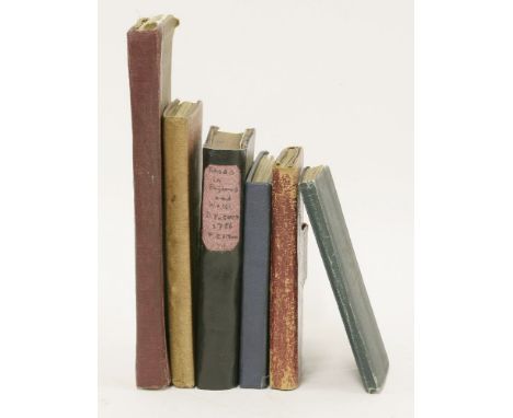
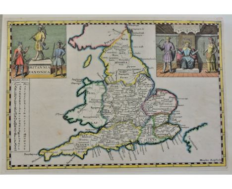
1- Cary's Traveller's Companion, or a Delineation of the Turnpike Roads of England and Wales. Printed for John Cary, 1791, first edition. With 42 of 43 coloured maps (lacking the folding map of Yorkshire). Contemporary full leather wallet binding; Hinges weak, o/w VG; 2- Paterson, Daniel: A new and accurate description of all the direct and principal cross roads in England and Wales. T. Carnan, 1786, 7th. edn. (price two shillings sewed); With a double-page map; PP: xxiv, 293, (i)ad. BOUND WITH: A travelling dictionary or, alphabetical tables of the distance of all the principal cities.. 1781, 4th. edn. PP: iv, 180. Home made crude leather binding; internally vg; 3- Kelly: Post Office Directory Map of London for 1913. Large coloured folding linen backed in original cloth covers and with the index. 36 sections, 4 inches to one mile; Light wear; 4- Post, Reise und Eisenbahnkarte von Deutschland, der Schweiz, den Niederlanden und Belgien. Glogau, Flemming, 1853, new revised edition. Large coloured folding linen backed in original buckram covers and with the index. 36 sections (87X106 cms.); Light wear; 5- Cruchley's Reduced Ordnance Map of England & Wales. Sheet 40. no date, c1880. Large coloured folding linen backed in original cloth covers; 2 miles to an inch; 36 sections; with tears to folds; covers worn; 6- W.H.Smith & Son’s MAP OF YORKSHIRE. 2/- Folding coloured linen backed in original cloth covers; Vg. (6)

Lot 9

John Speede GLOUCESTERSHIRE hand-coloured map, and double glazed, 38 x 51cm

Lot 158

1- Murray, J F: A Picturesque Tour of the River Thames. Bohn, 1845. Illustrated; bound by Riviere in full morocco with gilt decoration and aeg; slightly rubbed; 2- Davies' Map of the Environs of London. 1868. Coloured folding linen backed, in original covers. (2)

Lot 20

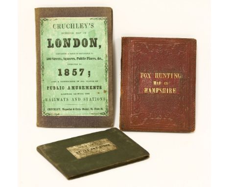
1- Cruchley's Superior Map of London, improved to 1857. Folding coloured linen backed in original covers; G; 2- Walker, J & C: Fox-Hunting Map of Hampshire and Isle of Wight. N.d. 15 sections, linen backed coloured folding, in original covers; vg; 3- Brown, J B: New Pap of the Drives & Rides in Windsor great Park. 8 small sections, coloured linen backed folding, in original covers. N.d. c1843. G. (3)

Lot 27

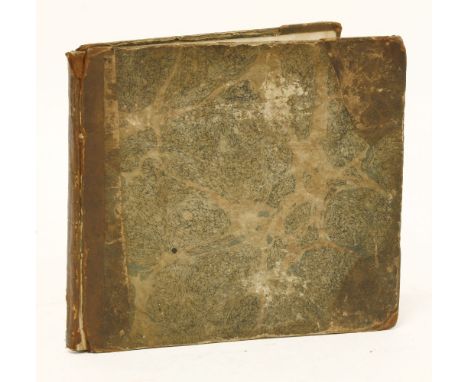
Taylor & Skinner's Survey and Maps of the Roads of North Britain or Scotland to His Grace John Duke of Argyll, Commander in Chief of His Majesty's Forces in North Britain &c. &c. For the authors as the act directs, the 20th March, 1776, and sold by D. Wilson… price 12 shillings, 1st. edn. Folding title page, folding index, fold map of Scotland, Plus 61 folding maps, engraved by Barber, .. and dated 1775-1776. Cont. full leather, later spine; some of the maps are dusty and little torn on folds.

Lot 24

Seller, John: Scripture Geography.. Lacking Title page; c1690. A collection of 27 hand coloured maps. Upper cover detached; first map torn and repaired, one with small tear to foredge and the last map with soiled verso.

Lot 7

John Speede THE COUNTIE WESTMORLAND hand-coloured map, and double glazed, 38 x 50cm

Lot 6

John Speede THE COUNTIE PALLATINE OF LANCASTER DESCRIBED AND DIVIDED INTO HUNDREDS, 1610 hand-coloured map, double glazed, 38 x 50cm

Lot 63

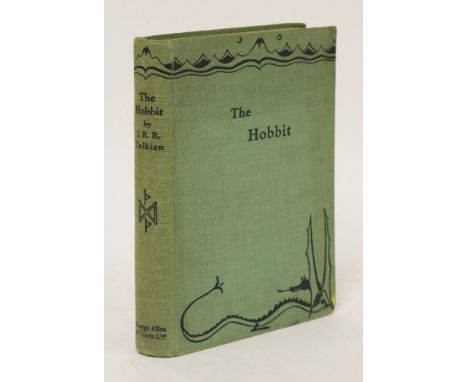
Tolkien, J. R. R.: The Hobbit or There and Back Again. George Allen and Unwin Ltd, London, 1937, First Edition, First Impression. With frontispiece and 9 plates or illustrations (all but one full-page), map endpapers in red and black by the author. PP310, (ii)publisher’s advertisements. Original Publisher's green cloth, lettered and decorated in dark blue. CONDITION: (Original un-restored condition). Covers little rubbed; inscription to front blank endpaper dated 1937; the frontis has been crudely coloured which has resulted in light offsetting to title page; otherwise a very good and firm copy. (Only 1500 copies were printed of this first edition, first impression).

Lot 443

The Fisherman's Map of the North Tyne River, by W N Bewick, colour print, the margin with watercolour drawing of an angler signed 'Ginty', together with an engraving of Edinburgh from Calton hill and another print (3)

Lot 20

A 20th CENTURY OAK TWO PART PLAN/MAP CHEST of six drawers, 83 cms high, 119 cms wide, 83 cms deep

Lot 728

17th century Saxton-Kip hand-coloured map of Essex, 30cm x 38cm, in glazed Hogarth frame

Lot 601

Regency embroidered sampler map of England and Wales, by Hester Saniger 1812, 68cm x 51cm, in glazed frame

Lot 256

William Kip, After Christopher Saxton, Lecestriae Comitatus Sive,coloured County map, 29 x 36cm, unframed, together with a Indenture, concerning a parcel of land between Inkerman Lodge and Quenby Lodge, document signed and sealed by Lady Henry Grosvenor, mounted and framed, (2).

Lot 269

Vellum hand drawn and coloured map, Berwick in Holderness, 1627.

Lot 268

Robert Malden, 'Leicester Shire', hand-coloured county map; William Kipp, 'Rutlandiae', hand-coloured county map; another county map of Rutland, and a map of Lincolnshire.(4)

Lot 299

John Speed, Leicester both Countye and Citie described, a hand coloured County map with the plan of the City, 38 x 51cm.

Lot 254

A Reproduction Framed World Map by Peter Schenk

Lot 54

Four folio albums of cigarette cards on topographical themes, including Famous Buildings, Maps, etc.' mainly full sets, including: (1) Adcock, 'Ancient Norwich'; Ardath, 'Real Photographs of Famous Landmarks'' Cohen, 'Interesting Buildings and Views'; Hill, 'Crystal Palace Souvenir Cards' (B); Millhoff, 'England Historic and Picturesque'; Moustafa 'Real Photographs', etc.; (2) Anstie, 'Wiltshire Downs' (Sectional); Ardath, 'Modern School Atlas'; C.W.S., 'Beauty Spots of Britain'; Carreras, 'Round the World Scenic Models'; Wills, 'Seaside Resorts' (mixed backs), etc; and (3) Gallaher, 'Interesting Views' (colour); Millhoff, 'Geographia Map Series' (London and the Home Counties); Ogdens, 'Picturesque Views'; 'Guinea Gold London Street Scenes' (78S); Phillips, 'Beauty Spots of the Homeland (PC), etc. (approx 43 sets)

Lot 327

Six 19th century engravings, 'A view of Bradford from Cliff Quarry', 'The Visit of the Prince of Wales to Newcastle-on-Tyne', 'The Queen's visit to Leed's', 'The Yorkshire Agriculture Society at Halifax', 'Birmingham 1858' and a map of Birmingham. Various sizes.

Lot 30

A 1974 Map of the County of Westmorland Commissioned by Paul N Wilson and executed by A Wainwright

Lot 8

A London underground map in the form of a mirror

Lot 512

Antique Maps - 1759 Miniature map from 'New and Accurate Maps of Countries of England and Wales',12cmx8cm,very fine, scarce.

Lot 245

Map - Bacons Norfolk County Map and Guide for Cyclists and Tourists, in waterproof cover. Well used.

Lot 295

(7) Propaganda WWII-1950's printed -Daily Mail-We want your kitchen waste, Keep mum she's not so dumb!-Coughs and sneezes spread diseases, Europe of the height of Axis Power Oct 1742, Is your journey really necessary!-Come help with the victory harvest-Campaign map Barbarossa 22nd June to 26th Sept 1941

Lot 525

Map-Surrey Circa 1834 by Archibald Fullertan Glasgow

Lot 529

Antique Maps - 1769 map from 'England Displayed'(Previously small British Atlas)20cmx16cm, very fine.

Lot 501

Antique Maps - 1828 Map from 'Encyclopaedia Londinensis' with many misspellings e.g. Hawkstead/Harkstead, Nedham/Needham, Eastrohoel/East Bergholt, Cradbrook/Craftfield, 25cmx20cm, very fine.

Lot 522

A Map of East Anglia-Mill aria Angelica Magna-Sumptibus Henrici Hondy-Written in Latin - on vellum and water coloured 1800 early

Lot 521

A Map of Isola Dimcelta Early 1800's-very detailed - ny Apud John. It-Cornel Blasu on Vellum

Lot 505

Antique Maps - 1810 Map from Wallis 'New Edition of the English Counties' miniature, 12cmx14cm,very fine, with excessive misspelling for the period.

Lot 519

A Map of Northamptonshire Engraved from an actual survey with improvements

Lot 532

Antique Maps - 1719 Road Map - Kings Lynn to Harwich from 'Principle Roads of England and Wales' reduced from Ogiby, 22cm x 15cm uncoloured, edge toning, very fine.

Lot 341

London: Geographic's London Maps & Guide, Bus map Central London 1935: how to get there by London Transport: London Transport Railway Track Map: London's Tramway Subway: Paddington Station 1854-79: London before the Blitz 1906-40

Lot 531

Antique Maps - 1759 Map from 'General magazines of Arts and Science/The Natural History of England, Hundreds inset, Borough Towns, Market Towns and Post stages shown,19cmx17cm, very fine

Lot 509

Antique Maps - 1834 Map from the 'New British Atlas' very fine. 24cmx19cm.

Lot 514

Antique Map - Yorkshire - West Riding 1610 John Speede. The West Ridinge of Yorkshire with the most famous and fayre Citie Yorke described 1610. City arms and insert map. Some imperfections but a wonderful map. Approx 20¼" x 15¾".

Lot 528

Antique Maps - 1966 Map from Elliss English Atlas(copied from Kitchins map of 1764)25cmx19cm, very fine.

Lot 503

Antique Maps - 1787 Map from English Atlas or Concise View of England and Wales, 13cmx12cm, very fine(page 37)

Lot 223

Canadian Pacific-The Short Seaway to Europe-printed 1932-Advertising brochure for Cruises to Europe- includes route map.

Lot 513

Antique Map - Yorkshire John Ogilby - the road from York to Lancaster, evenly toned, edges worn at right but intact for framing. Approx 19" x 14½".

Lot 507

Antique Maps - 1818 Map from 'Excursions through Suffolk' very fine, folding crease.

Lot 524

Antique Map-Denbighshire drawn & engraved by J Archer -Pentonville London

Lot 502

Suffolk 1787-A map of Suffolk by John Cary, from the 'New and Correct Atlas' (26cmx22cm) very fine.

Lot 506

Antique Maps - 1812 map from 'New and Improved County Atlas, 26x18mm, very fine, hundreds listed inset.

Lot 526

Antique Maps - England, Hermannides,1661 Map and Cartouches 'Britannia Saxonica' from Britannia Magna(Amsterdam) engraved by M Burghers. A rare colourful, beautiful and scarce map,28cmx20cm.

Lot 504

Antique Maps - 1807 Map from 'Universal Magazine' the Laurie and Whittles New and Improved Atlas 24cmx18cm very fine, some edge paper toned.

Lot 530

Antique Maps - 1764 map from 'England Illustrated'26mm x 19mm, very fine.

Lot 534

Antique Maps - Suffolk,Taylor-Blome,1715 map from 'England Exactly Described' decorative with Lord Cornwallis Arms and Hundreds in Suffolk inset.24cm x 17cm.Very Fine.

Lot 508

Antique Maps - 1817 Map Ipswich Town, from Excursions in Suffolk' folding crease, very fine.

Lot 520

Second Map of Northamptonshire Engraved from an actual survey with improvements

Lot 527

Antique Maps - 1769 map from New British Traveller(1784)embellished surrounds, published by Alexander Hogg, 21cmx16cm, very fine, some page edge toning.

Lot 515

Antique Map - Yorkshire - West Riding 1607-1610 C.Saxton/W.Hole copper plate coloured, 'Edoracensis comitatus pas orientalis', vulgo West Riding. A scarce map. Approx 14¼" x 12½".

Lot 233

Vintage AA Map of England & Wales 1950's-60's With some routes marked in blue crayon.

Lot 533

Antique Maps - 1719 Road Map - Kings Lynn to Harwich from 'Principle Roads of England and Wales' reduced from Ogiby, 22cm x 15cm uncoloured, edge toning, very fine.

Lot 535

Antique Maps - Suffolk Blome, R1693 Map from ' Cosmography' decorative, dedicated to Charles, Lord Cornwallis, Baron of Eyr (Arm Inset) Hundred of Suffolk also inset 25cmx17cm Very fine.

Lot 510

Antique Maps - 1846 Map from 'parliamentary Gazetteer of England and Wales'24cmx19cm, very fine, some toning.

Lot 509

LOW TABLE, of substantial proportions, the glazed top lined with a map of London in the reign of William IV (circa 1830), 134cm D x 197cm L x 42cm H.

Lot 1502

A framed and glazed map of Lincolnshire

Lot 18

A 17thC coloured map of Devon Shire by Robert Morden in modern frame.

Loading...Loading...
  • 109198 item(s)
    /page

Recently Viewed Lots