We found 109182 price guide item(s) matching your search
There are 109182 lots that match your search criteria. Subscribe now to get instant access to the full price guide service.
Click here to subscribe- List
- Grid
-
109182 item(s)/page


Lot 842
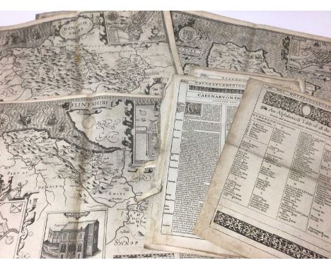
Collection of John Speed Welsh maps, all circa 1627, Anglesey, Denbighshire, Flintshire, Montgomeryshire, Caernarvon, Cardiganshire, Radnor, Breknoke, Monmouthshire, Glamorganshire, Merionethshire, Penbrokshyre, and a map of Wales, all with English text verso (condition various).Anglesey, losses to margins, particularly lower corners, stains Denbighshire, tears to margins, creases, some staining Flintshire, staining, small losses to marginsCaernarfon, losses to lower corners and margins, vertical split centrally from bottom edge, some staining Cardiganshire, poor condition, losses and tears particularly to lower corners and marginsmontgomeryshire, tears to marins and staining particularly to lower corners, creases Radnor, quite damaged to lower corners and tears to margins, tear from top centrally, further small tear centrallyBreknoke, poor condition, large tear centrally, losses to corners and margins, mostly outside the plate markMonmouthshire, losses to lower corners and margins, staining Glamorganshire, damage to margins particularly lower corners, staining, vertical tear from lower edge centrallyMerionethshire, losses to margins and corners, extends to some elements inside plate, staining Pembroke, damage to margins and lower corners, staining map of Wales, poor condition losses to margins and print


Lot 844
John Speed - 17th century engraved Map of America, dated 1626 (but 1676), sold by Baskett and Chiswell, pen inscriptions to margin, English text verso, plate 40 x 51cmNot repaired. A little staining particularly centrally, a few very small tears in the margins, overall condition is mostly good and original

Lot 845
John Ogilby - rare engraved Map of Carolina, 1672 - "A New Discription of Carolina By Order of the Lords Proprietors" from Ogliby's, America; uncolored engraving on laid paper with watermark, engraved by James Moxon, 43 x 53cmMap is trimmed approximately to the margins. A few small tears to outer edge, grubby marks and creases. No holes, no restoration and no severe damages


Lot 382
EDWARDS, RINGER & BIGG: A Tour Round The World, 1909, part set 11/50; STEPHEN MITCHELL: Clan Tartans, circa 1927, second series, Full set of 25; GODFREY PHILLIPS: Statues & Monuments, 1907, fifteen cards; BDV/GODFREY PHILLIPS: Semaphore Signalling & Morse, 1916, two cards; GALLAHER: Boy Scout series, 1911, part set 60/100; HIGNETT: Greetings of The World, 1907, Full set of 25; STEPHEN MITCHELL: Statues & Monuments, 1914, part set 10/25; OGDENS: Boy Scouts (blueback, 1st series), part set 30/50; OGDENS: Boy Scouts (part sets of 2nd, 3rd, & 4th series); OGDENS: Sectional Cycling Map, 1931, part set 14/50; PLAYERS: Gilbert & Sullivan, 1925, part set 14/50; PLAYERS: Gilbert & Sullivan, 2nd series, 1927, Full set of 50; OLAYERS: Celebrated Bridges, circa 1903, part set 13/50; PLAYERS: Highland Clans, 1908, Full set of 25; Boy Scout & Girl Guides, 1933, part set 13/50; SENIOR SERVICE: Beautiful Scotland, 1939, part set 22/48; WILLS: Musical Celebrities, 1912, Full set of 50; WILLS: Musical Celebrities, 2nd series, 1916, part set 40/50; WILLS: Gems of Belgian Architecture, 1915, Full set of 50; WILLS: Gems of French Architecture, 1916, Full set of 50; WILLS: Gems of Russian Architecture, 1917(?), Full set of 50; FRY’S: Scout Series, 1912, six cards only; Various other part sets & odd cards.

Lot 395
BRITISH AMERICAN TOBACCO : Britain's Defenders, 1914, part set: 16/50; BEANO BUBBLE GUM: This Age of Speed, 1954, Nos 6, 7, 17, 18, 28, 32, 40 & 46; CHURCHMAN: The Navy at Work (large), 1937, part set: 21/48; CHURCHMAN: The RAF at Work (large), 1938, part set: 14/48; CHURCHMAN: Kings of Speed, 1939, Full Set of 50; EDWARDS, RINGER & BIGG: War Map, Western Front, 1916, Nos 43 & 49 only; EDWARDS, RINGER & BIGG (New York Mixture): War Map of The Western front, Nos 3 & 28 only; GODFREY PHILIPS: Speed Champions, 1930, Full Set of 30; LAMBERT & BUTLER: Naval Portraits, 1915, part set: 46/50; LAMBERT BUTLER : Naval Portraits, 1914, part set: 20/25; MAJOR DRAPKIN: Clebrities of The Great War, 1916, seventeen cards; OGDENS (Guinea Gold): Boer War black & white portraits, 26 cards; OGDENS (Tabs): Leading Generals of The War, circa 1900, nineteen Cards; OGDENS (Tabs): Prominent British Officers, 1901, fifteen cards; OGDENS (Tabs): Imperial/International Interest, circa 1901, thirty four cards; OGDENS: Marvels of Motion, 1928, Full Set of 25; OGDENS: Records of The World, 1908, part set: 20/25; ARDATH (STATE EXPRESS) Speed - Land, Sea, & Air, 1935, Full Set of 50; SMITHS: Battlefields of Great Britain, 1913, part set: 13/50; SMITHS: War Incidents, 1st series, 1914, part set: 13/25; SMITHS: War Incidents, 2nd series, 1915, part set: 5/25; WILLS: Russo-Japanese series, circa 1905, Full Set of 50; WILLS: Transvaal series, 1900, sixty seven cards, with Nos 1-30 inclusive; WILLS (Scissors, slanting packet): Britain's Defenders, 1915, part set: 44/50; WILLS (Scissors, upright packet): Britain's Defenders, 1915, part set: 19/50; WILLS: Britain's Part in The War, 1917, Full Set of 24; WILLS: Speed, 1930, Full Set of 50; WILLS: Speed, 1938, Full Set of 50; WIZARD (Comics): Speed, 1959, Full Set of 48.


Lot 119
A collection of Adam & Charles Black colour illustrated books, many with decorative boards: Steel (Flora Annie) & Menpes (Mortimer, Illus.), India, 1905, 1st edition, 75 colour plates with captioned tissue guards; Talbot Kelly (R) [illus.], Burma Painted and Described, 1905, 1st edition, 75 colour plates with captioned tissue guards, fold-out map; Bagot (Richard) & Du Cane (Ella, Illus.), The Italian Lakes, 1912 reprint, 68 colour plates with captioned tissue guards; Goff (Clarissa) & Goff Colonel R.C, Illus.), Florence & Some Tuscan Cities, c.1905, 1st edition, 75 colour plates with captioned tissue guards; Jungman (Beatrix) & Jungman Nico, Illus.), Holland, 1904, 1st edition, 75 colour plates with captioned tissue guards; Austin (Mary) & Palmer (Sutton, Illus.), California, The Land of The Sun, 1914, 1st edition, 32 colour plates with captioned tissue guards; Musson (Spencer C.) & Hardwicke Lewis (J, Illus.), Cote d'Emeraude, 1912, 1st edition, 20 colour plates with captioned tissue guards and fold-out map; Home (Gordon) & Menpes (Mortimer & others, Illus.), France, 1918 re-issued with 64 colour plates with captioned tissue guards and map pg.212; Wigram (Edgar T.A. described & Illus.), Northern Spain, 1906, 1st edition, 75 colour plates with captioned tissue guards and fold-out map; Fedden (Katherine) & Fedden (Romily, Illus.), The Basque Country, 1921, 1st edition, 24 colour plates with captioned tissue guards and fold-out map; Kelman (John) & Fulleylove (John, Illus.), The Holy Land, 1912 reprint, 93 colour plates with captioned tissue guards; Du Cane (Florence) & Du Cane Ella, Illus.), The Canary Islands, 1911, 1st edition, 20 colour plates with captioned tissue guards and fold-out map; MacKenzie (W.M.) & Pisa (Alberto, Illus.), Pompeii, 1910, 1st edition, 20 colour plates with captioned tissue guards; Grove (Henry M) & De Haenen (F, Illus.), Moscow, 1912, 1st edition, 32 colour plates with captioned tissue guards; Munro (Neil) & Houston (George, Illus.), Ayrshire Idylls, 1912, 1st edition, 20 colour plates; Moncreiff (A.R. Hope) & Palmer (Sutton, Illus.), The Heart of Scotland, 1912, 1st edition, 24 colour plates with captioned tissue guards and fold-out map. (condition varies). (16)
Lot 466
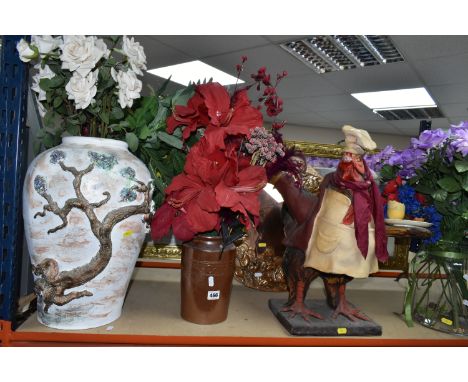
VASES AND DECORATIVE MIRROR FIRE SCREENS ETC, comprising a circular copper covered mirror with a rose coloured centre, a fire screen mirror with a hunting scene print to the middle, large earthenware floor vase with applied tree motif, approximate height 45cm, a glass vase approximate height 25cm, a fiberglass chicken sculpture, a salt glazed storage jar, and a fire screen with a reproduction Johannes Blau map of the world
Lot 517
SIX BOXES OF BOOKS AND EPHEMERA, to include a school exercise book belonging to a George Picker, who went to Leadenham School, dated October 26th 1846, with a short note about George inside, three photographs of an Edwardian gentleman, two Shakespeare Memorial Theatre/ The Royal Shakespeare Theatre season programmes from the early 1960s, an Ordnance Survey map of Ruthin and surrounding areas dated 1879, approximately one hundred and forty books in hardback and paperback formats, mainly fiction including antiquarian and vintage titles, authors to include Kathy Reichs, Lynda La Plante, Terry Pratchett and Patricia Cornwell, with some history and other titles (6 boxes) (sd)
Lot 475
A QUANTITY OF 17TH, 18TH AND 19TH CENTURY WELSH AND ENGLISH MAPS, to include a John Speed map of Wales with counties either side circa 1610, John Speed Denbighshire map, Denbigh map by William Kip and Christopher Saxton, Denbigh and Flintshire by Saxton and Philip Lea, North Wales by H. Moll, London to Holy Head road map by John Ogilby - poor condition, various other maps of Wales and Denbighshire including road maps, Thomas Moule map of Darbyshire (Derbyshire) and a Dutch map of Staffordshire by Emanuel Bowen etc., to include framed and loose maps


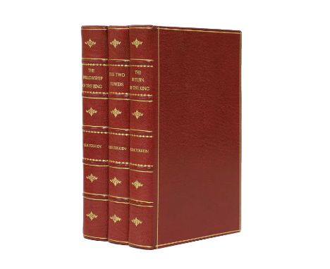
Lot 103
TOLKIEN. J R R: THE LORD OF THE RINGS. The Fellowship of the Ring. - The Two Towers. - The Return of the King. 3 Volumes. George Allen & Unwin. London. 1954-1955, First Editions, Vols. 1 and 2 are 2nd Impression; Vol. 3 1st. Impression. Recent full red morocco with raised bands, original spines bound-in, marbled endpapers and all edges gilt. Fold-out map present in all three volumes. A Very Good set (3)

Lot 50
Visscher: Hemisphere world map. Surrounded by landscapes of the world and how they were divided and inhabited by Noah’s descendants. Dutch text to verso. c.1700, Hand-coloured, 30 x 44cm; Plus: Homann: Geographica Nova ex Oriente gratiosissima. Mare Caspium & Kamtzadaliam seu Terram. [Nuremberg], c.1730. Hand-coloured, 48 x 58cm (2)


Lot 185
NORFOLK: Taylor, William: The Antiquities of King's Lynn. Norfolk. Lynn, J Thew, 1844, 1st. Edn. Complete with 30 plates. PP: viii (including Subscribers' list), 158, (ii). Original cloth; rubbed; Goulburn, E M & H Symonds: The Ancient Sculptures in the Roof of Norwich Cathedral. 1876, with numerous plates. Folio, Ex-Libra, with the usual stamps. Original board and later leather spine. G+; Blomefield, Francis: An Essay Towards a Topographical History of the County of Norfolk. First two volumes only. 1805, new edn. with Frontis, 6 plates and 7 folding tables. Cont. half leather; rubbed; A General History of the County of Norfolk, in two volumes. Norwich, 1829. lacking the map in vol.1; Martin, T: The History of the Town of Thetford.. 1779, 1st. Edn. 4to. Frontis plus 9 plates. Defective/restored copy: [The Frontis, two plates, the first 3 leaves and last page of index are supplied in facsimile. The edges of two leaves professional restored). Recent half leather; Plus one other, A/F (8) Provenance: Anne F Sutton's collection, most with her bookplate.

Lot 150
FINE BINDING: Ireland: New and complete history of the county of Kent, in 4 vols. Virtue, 1828-30. Folding map and plates. Half leather, VG; Molière: Oeuvres Complètes, 8 vols. Paris, 1829. Cont. half leather; VG; Addison: The Spectator, 6 vols. 1766. Cont. full calf; rubbed; Goldsmith: History of the Earth and animated nature. 1817, with hand-coloured plates. Half leather; rubbed; Wraxall: Historical memoirs of my own time, 2 vols. 1815; and Bunyan: Pilgrim's progress, 1809 (22)
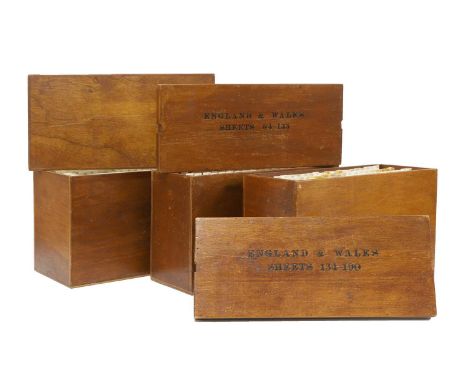
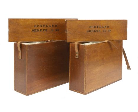
Lot 42
Ordnance Survey of England and Wales: Complete set of the 7th Series. 190 one-inch colour maps, each dissected into 6 sections laid on linen, with numbering tabs, preserved in the publisher’s three original purpose-made wooden map chests, each with the relevant index sheet pasted to the inside of the lid. Plus 3 index maps, plus a loosely inserted letter on 'Ordnance Survey' headed paper, dated 8 July 1959 and addressed to General R L Brown, CB. CBE. This set and the following set for Scotland, being retirement presents. A VERY GOOD/FINE SET (3)

Lot 53
Jan Huygen Van & Hendrik Floris Van Langren: LINSCHOTEN, Deliniantur in hac tabula, Orae Maritimae Abexiae, freti Mecani; al Maris Rubri; Arabiae, Ormi, Persiae... [Amsterdam: 1596] or later. Engraved hand-coloured map of Arabia, Persia and India from Linschoten's Itinerario. Title in Latin and Dutch. Hand-coloured, mounted, framed and glazed, 39 x 53cm
Lot 227
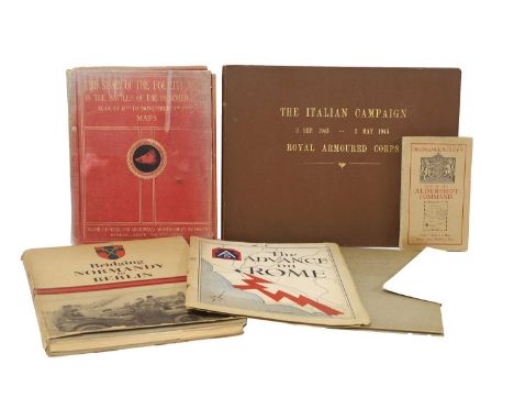
MILITARY, WW2: Bridging Normandy to Berlin, 1945, folio, DW, fully illustrated; Montgomery, Major General: The Story of the Fourth Army in the battles of the hundred days, August 8th to November 11th.1918. Map volume only, with 19 folding maps Plus 5 out of 7 folding Panoramic views; Letter from R L Brown, Brigadier director of Survey Allied forces Headquarters US Army, 16 Feb 1945. Presentation copy: enclosed, and present, a copy of 'the Advance on Rome'; A collection of General Montgomery’s personal messages to the Eight Army, 1944, in plain card boards; The Italian campaign 3 Sept 1943 – 2 May 1945 Royal Armoured Corps; Two ordnance survey maps: Aldershot Command; and Syria, Beirut section; 'Utah Beach to Cherbourg'. 1 October 1947, with the maps; 'Beachheads and Mountains'. Mediterranean Theatre of Operations, U.S. Army. June 1945; 'Fifteenth Air Force A Summary of its Operations and Results'. 1 November 1943 – 8 May 19. Classified Restricted; 'Goodbye to All This' 518 Field Survey Company. Royal Engineers. Inscribed by the men to Brigadier R.Ll.Brown OBE [Our client's Grandfather, he was head of survey for the 8th Army, and at AFHQ in Italy]; & 'History of AFHQ'. 9 paperback volumes. Volume 1 classified Confidential; remaining volumes classified Restricted (qty.)

Lot 165
BINDING, including: Parish, Woodbine: Buenos Ayres and the Provinces of the Rio de la Plata. From their Discovery and Conquest by the Spaniards to the Establishment of their Political Independence. Murray, 1852, 2nd Edn. With a frontis, tinted plates, coloured folding linen-backed map, etc. Cont. half leather (qty.)Provenance: From an important English private collection.
![Hughes, Griffith: The Natural History of Barbados. In Ten Books. [Printed for the Author, London, 1750, 1st. Edn.]. Lacking t](https://cdn.globalauctionplatform.com/34704cd5-4b5a-4275-9164-b15600fff628/0653d8f9-3e46-40c2-a990-b15a00ef4c0c/468x382.jpg)
Lot 198
Hughes, Griffith: The Natural History of Barbados. In Ten Books. [Printed for the Author, London, 1750, 1st. Edn.]. Lacking the title page; PP: ii-vii, (I) Errata, (x) Subscribers' list, (ii) Contents, etc., 317, (xix). All plates are present: Large folding map Plus 30 Plates by EHRET. 4to. Cont. full leather, rubbed and upper cover detached. Tears and repairs with small loss to a number of pages. SOLD AS A COLLECTION OF PLATES, NOT SUBJECT TO RETURN
Lot 127
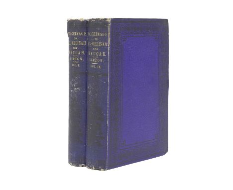
Burton, Richard: Personal Narrative of a Pilgrimage to El Medinah and Meccah. Longman, Brown, Green & Longmans 1855, First edition, [volumes one and two only of three volumes]. PP: V1- xiv, (i) Errata, (i) blank, 388, 24 (publisher's catalogue, dated Nov. 1855), Plus: Tinted frontis, folding Map and two colour plates; V2- iv, 426, Plus: colour frontis, folding map and three tinted plates. Original boards with the publisher’s catalogue as endpapers in volume two. Good copies (2)

Lot 242
TOLKIEN, J R R: The Hobbit, or There and Back Again. George Allen & Unwin, 1955, 7th Impression. Colour frontis and 8 illustrations (7 are full page), and endpaper maps. Original pictorial cloth, rubbed and tears to spine; The Lord of The Rings, 3 vols. George Allen & Unwin: The Fellowship of the Ring, 1954, 2nd. Impression (same year as 1st Impression); The two Towers, 1955, 2nd. Impression (Two copies); and The Return of The King, 1955, 1st. Impression, Covers rubbed and with tears; Lacking the map in the first volume, but present in the others (5)

Lot 11
SCOTLAND (2 Maps): DE WIT, F: Novissima prae caeteris aliis accuratissima Regnorum Angliae, Scotiae, Hiberniae, Amsterdam, c.1690. Hand-coloured engraved map, 58 x 49cm; Visscher, N: Exactissima Regni Scotiae Tabula tam in Septentrionalem et Meridionalem quam in minores earumdem Provincias. Amsterdam, c.1680, hand-coloured engraved map, 58 x 49cm (2)

Lot 50A
MAPPA MUNDI: The Hereford World Map, The Folio Society, 2010, Limited edition Facsimile of 1000 copies, this being number 502. The map is mounted, framed and glazed. It is accompanied with two books: an Introduction by P D A Harvey and a Commentary by Scott D Westram. The map's overall measurements: 125 x 150cm. The two volumes with slipcases. Inscription to the half titles of the two volumes. Plus the map box (4)

Lot 183
YORKSHIRE: Whitaker, T D: The History and Antiquities of the Deanery of Craven in the County of York. 1812, 2nd. Edn. 4to. Map and all plates present (one hand-coloured). Cont. half leather; rubbed; offsetting; The Victoria History of the Counties of England, Yorkshire North Riding, 2 vols. c.1920s. Maps and plates. Cont. half leather, not matching; Hunter, J: South Yorkshire (2 Volume Set). 1974, DWS, FINE COPIES; An Old York Church, All Hallows in North Street. Its Mediaeval Stained Glass and Architecture, York, 1908 Numbered Limited Edition number 248/500. Folio (6)Provenance: Anne F Sutton's collection, most with her bookplate.


Lot 43
FOLIO SOCIETY, Limited Edition: QUEEN MARY ATLAS. Two Volumes. Folio Society, 2005. Limited Edition No. 581 of 1000. Folio, Bound in full calf leather. Binding design by David Eccles, featuring the conjoined arms of England and Spain. 12 double-page maps and charts. Each map mounted on a guard, so that it opens absolutely flat. Commentary volume by Peter Barber, bound in full buckram with inset leather spine label. Both volumes housed in the original buckram clamshell box. FINE

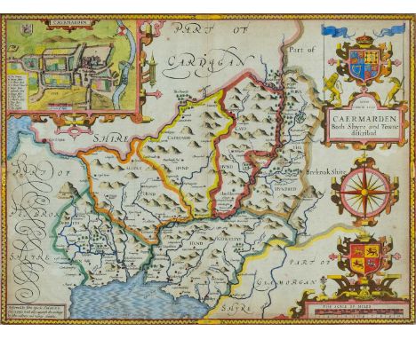
Lot 89
JOHN SPEED coloured 1610 copper engraved map - entitled in cartouche 'Caermarden, Both Shyre and Town described', with inset plan of Carmarthen town, scale of miles, compass and other illustrations, 39 x 52cmsProvenance: the Welsh art collection of award-winning television producer, the late Pat Llewellyn (1962-2017), by descentComments: framed and glazed, ready to hang


-
109182 item(s)/page