We found 109182 price guide item(s) matching your search
There are 109182 lots that match your search criteria. Subscribe now to get instant access to the full price guide service.
Click here to subscribe- List
- Grid
-
109182 item(s)/page


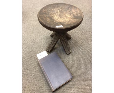
Lot 11
A Nigerian Niger Ibos carved wooden chieftain stool, with carved underside to the circular seat above a carved four-way support, overall height 29 cm, overall diameter of seat 28 cm, offered together with a copy of the volume "Niger Ibos" by G. T. Basden, with 70 illustrations & a sketch map, published by Seeley, Service & Co. Ltd., hardbound in blue cloth, 448 pages including index. (2)


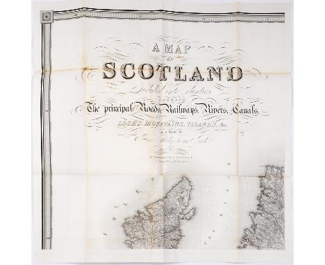
Lot 975
Lewis (Samuel) publisher - A Topographical Dictionary of Scotland comprising the several Counties, Island, Cities, Burgh and Market Towns, Parishes and Principal Villages...embellished with a large map of Scotland...supplementary volume: Map of Scotland Scale 10miles:1 inch, engravings on six folded sheets, slightly separating in the cross folds, title and contents leaf, contemporary cloth, 4to, London: S Lewis & Co 1846 Condition


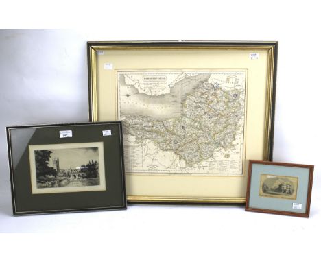
Lot 414
TWO COPPERCRAFT ETCHINGS AND TWO NOVELTY GOLF AND FISHING DISPLAYS, to include a CopperCraft etching of 'Dorsetshyre' and 'A New Accvrat Map of the World', length 40cm x width 32cm, a novelty display case of early golf clubs and balls, length 80cm x width 23.5cm, together with a novelty display case of fishing equipment, length 80cm x width 23.5cm (s.d) (4)


Lot 102
LAWRENCE (T.E) - SEVEN PILLARS OF WISDOM AND OTHERS Comprising: Seven Pillars of Wisdom, Jonathan Cape, London 1935, First general circulation edition; Oriental Assembly, Williams & Norgate, 1939, First Edition, with dust jacket; The Mint, by 352087 A/c Ross, Jonathan Cape, 1955, First Edition, with dust jacket; together with Thomas (Bertram), Arabia Felix, with introduction by T E Lawrence, 1936 re-issue, with dust jacket, numerous black and white photographic illustrations and fold out map (4) Condition: Condition Report Seven Pillars with significant foxing throughout and wear to binding; the other two examples with discolouration to dust jackets, and some foxing in places This is an auction of preowned and antique items. Many items are of an age or nature which precludes their being in perfect condition and you should expect general wear and tear commensurate with age and use. We strongly advise you to examine items before you bid. Condition reports are provided as a goodwill gesture and are our general assessment of damage and restoration. Whilst care is taken in their drafting, they are for guidance only. We will not be held responsible for oversights concerning damage or restoration.
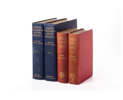
Lot 97
SAVAGE-LANDOR (A. HENRY) - ACROSS UNKNOWN SOUTH AMERICA Hodder and Stoughton, 1913, First edition, 2 vol, portrait frontispiece, numerous illustrations, two maps to Vol I, blue cloth boards with gilt decoration; and Across Coveted Lands, Macmillan & Co, London 1902, 2 vol, black and white photographic illustrations and folding maps, red cloth binding (4) Condition: Condition Report Unknown South America: Wear to covers and cover edges on both volumes, some fading and staining to cover of vol I, pages a little browned but generally clean. Across Coveted Lands: Binding to Vol I detached at spine, fading and staining to covers on both vols, folding map tend of vol I and vol II present, some browning to pages, particularly endpapers, general signs of age and wear This is an auction of preowned and antique items. Many items are of an age or nature which precludes their being in perfect condition and you should expect general wear and tear commensurate with age and use. We strongly advise you to examine items before you bid. Condition reports are provided as a goodwill gesture and are our general assessment of damage and restoration. Whilst care is taken in their drafting, they are for guidance only. We will not be held responsible for oversights concerning damage or restoration.


Lot 261
Henry Schenck Tanner (1786-1858) - Folding engraved map with hand colouring in outline - "United States of America: by H. S. Tanner, 1836", in thirty two sections with linen backing, "Engraved by H. S. Tanner: assisted by E. B. Dawson, W. Allen and J. Knight," with title vignette after James W. Steel, sheet size 46.75ins x 61.75ins

Lot 331
Assorted Cotton and Silk Souvenir and Commemorative Handkerchiefs, including linen Coronation tea towel, Union Jack handkerchiefs, lace trimmed and embroidered examples etc, various sizes; Souvenir of the Great War cotton printed handkerchief, AAF Cloth Map, no32 Asiatic Series; gentlemen's cream silk examples, some with embroidery, gents evening scarves etc (one box)

Lot 6539
Benjamin Cole (British1697-1783): 'Porsoken Ward with its Division into Parishes according to a New Survey' 'Cripplegate Ward with its Division into Parishes' 'Baynards castle Ward and Faringdon Wardand' and 'New and Accurate Survey of the the Parishes of (London)' Holbourne etc., five 18th century engraved maps two with hand colouring; Robert Morden (British 1650-1703): 'Sussex', engraved map with hand colouring; Richard Phillips (British 1767-1840): 'Asia' 'South America' 'North America' 'Africa' 'Europe' and 'British Isles', six engraved maps pub c.1808; Thomas Bowen (British d.1790): 'View of the Coast of Japan When We First Saw It', 18th century engraved map with hand colouring together with large collection of maps (25+)

Lot 268
IDES (EVERT YSBRANTS) IDES (EVERT YSBRANTS), Three years Travel from Moscow overland to China, 1 volume, 1706, new quarter leather, very scarce this copy lacks the foldout map of China and only has the frontispiece and 14 of the single page plates so it has 8 single and 8 folding plates missing. Also in this lot is another scarcity, Maundrell, Henry, - A Journey from Aleppo to Jerusalem, 1 volume, later edition, 1749, similarly scarce, but this copy has only 9 folding plates, including the frontispiece which is bound further in the book, as required but is missing 4 out of the 8 usually present single page plates.


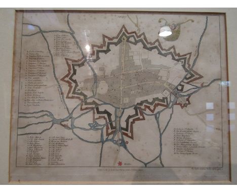
![[Johannes Blaeu] A 17th Century framed map of 'Cumbria vulgo Cumberland', having French text verso, hand coloured engraving,](https://cdn.globalauctionplatform.com/79135fcc-78b8-4348-bb70-aedf00d9e324/cc7b3d0c-329c-4e29-95c1-aee101000f65/468x382.jpg)
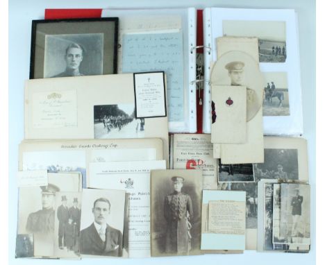
Lot 14
A large group of documents pertaining to Lieutenant Frederic William Joseph MacDonald Miller, Grenadier Guards, killed in action October 23rd 1914, aged 22, the eldest son of Sir William Miller Baronet, of Glenlee, educated at Sandhurst and gazetted to the Grenadier Guards in February of 1912, the group includes a very large volume of personal correspondence largely from Miller to his parents, written from a very young age up until October 18th, 1914, including approximately 17 letters written during the War, the group also includes a number of civilian and military photographs, including group and other portraits, depictions of society life, horse racing, military training and life in the field, also his military commission, a map entitled "Lieut F W J M MIller's (Grenadier Guards) Grave", In Memoria, research notes etc. [Ponsonby's "Grenadier Guards in the Great War" records Miller embarked with 2nd Battalion on 12 August 1914 and was killed by a high explosive shell whilst commanding Number 2 Company, likely during the Battle of Langermark (Zonnebeke-Langermark Road), he is remembered at Menin Gate Memorial, panel 9 and 11.]
Lot 2177
MICHAEL (20TH CENTURY) (16)A castle on a hillsigned 'MICHAEL' (lower left)oil on board40 x 32cmtogether with a Japanese print of women, 34 x 73cm; a Christopher Saxton map of Cheshire, 25 x 30cm; a Robert Morden map of Madagascar, 11 x 13cm; and twelve other prints and watercolours of various subjects by various hands of various sizes(16)

Lot 1367
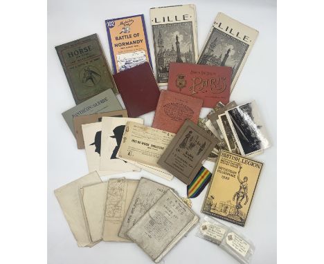
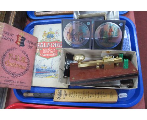
Morse Code Machine, a set of eight Victorian lantern slides 'Sweep' and 'Whitewasher', a small commemorative cricket bat for the 1938 Australian Touring team, a 1901 book of the N.U.T. Conference in Great Yarmouth (many fascinating adverts) and a 1924 Salford guide book with coloured g=drawing and pull-out map. (5 items)


Lot 1577
A very large group of general ephemera comprising a selection of Victorian photo albums with some photography, many 1930's Birthday cards with a good amount unused. Interesting Danish greeting cards on very fragile paper, copyright L. Levison Jr plus other interesting items including cigarette cards, old Street Map of Harpenden and more. Autograph album not included.


![[MISCELLANEOUS] Nine assorted works, comprising Eyles, Desmond. The Doulton Lambeth Wares, first edition, Hutchinson, London](https://cdn.globalauctionplatform.com/49e76f8a-bf28-4f92-aa5f-aea000a70864/df27484d-664e-467f-b362-aedf011b657a/468x382.jpg)
Lot 383
[MISCELLANEOUS] Nine assorted works, comprising Eyles, Desmond. The Doulton Lambeth Wares, first edition, Hutchinson, London, 1975, cloth, dustjacket, illustrations, quarto; Metz, Katharina et al., European Textile Design of the 1920s, Edition Stemmle, Zurich, 1999, boards, dustjacket, illustrations, quarto; and seven others; together with a folding map, (10).

-
109182 item(s)/page