We found 109182 price guide item(s) matching your search
There are 109182 lots that match your search criteria. Subscribe now to get instant access to the full price guide service.
Click here to subscribe- List
- Grid
-
109182 item(s)/page


Lot 530
A collection of S.A.S and Paratrooper items, owned by Charles Thomas Williams, comprising ties, handkerchiefs, wooden wall plaque, plastic plaque, framed items and more (parcel)Announcement - this lot also comes with an inert 1.5'' Anti Riot rubber round L2A2 and a double sided 'New Frontier' Belgium & Germany Silk map,


Lot 217
A collection of ephemera - Image of bridge construction 1800's, Retro Argument Settler for Prime Ministers, various prints of various engravings. Pages for newspapers (French and English) Virtue and Co map of surrey, Illustrated London news pages. The Graphic magazine from 1911 Christmas numbers, Special aviation section of The Sphere, amateur radio prefixes for commonwealth areas, 1708 title page.
Lot 315
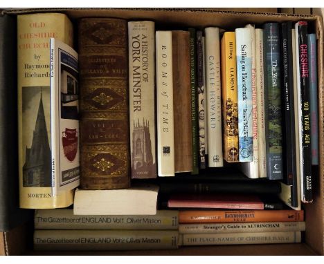
Topography to include:-Worsfold, W Basil "Twenty Centuries of England being the annals of Bishop's Stortford ...", plates, illustrations in the text and maps, printed and produced by Cheltenham Press Limited, Cheltenham & London, publishers Ed J Burrow & Co, No.1 signed by the author, errata slip, blue ep, blue cloth with gilt titles, some fading from shelf wear Dearn, T D W"An Historical Topographical and Descriptive Accounts of the Wield of Kent ...", Cranbrook, printed for and sold by S Reader 1814, map present, no indication of engravings, contemporary boards, backstrip missing, stitching coming throughWilson, John Marius "The Imperial Gazetteer of England and Wales ...", A Fullarton & Co 1874Richards, Raymond"Old Cheshire Churches"Brindley, W H (ed) "Soul of Manchester", Manchester University Press 1929, dj and various other related volumes (3 boxes)
Lot 367
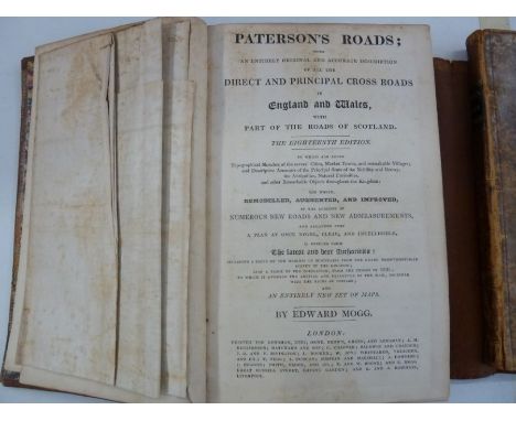
Mogg, Edward"Paterson's Roads ... Direct and Principal Cross Roads in England and Wales with part of the Roads in Scotland ... the 18th edition ...", printed for Longman Reece Orme Brown Green & Longman, etc, folding map, frontis, creased but no loss, all maps present and the Holyhead Road plate, contemporary binding, full leather, some foxing, marbled boards, leather wallet style"Cary's Survey of the High Roads from London to Hampton Court ...", printed for J Cary engraver and map seller, no.181 Strand, July 1st 1810, coloured strip maps, some offsetting to free ep and a piece cut out of the top of the second ep, contemporary marbled calf, front hinge cracked, gilt title on pastedown to backstrip and backstrip splitting slightly, corners bumped (2)

Lot 397
Wallis's New Geographical Game, Exhibiting a Tour Through England and Wales", London, published John Wallis 1802, engraved map with contemporary hand-colouring, sectionalised and laid on linen, two columns of rules and town descriptions, 51cm x 66cm, in contemporary card slip case with the publishers printed label, both with worn and split, with small tear on the publishers label Condition ReportPlease see additional image

Lot 405
MOUNTAINEERING - Harrer Heinrich " The White Spider, The History of the Eiger's North Face" Rupert Hart-Davis 1959, photographic plates, one folding with details of the North Face, ex libris plate ffep, d-j, Herrligkoffer Karl M. " Nanga Parbat...." Elek Books 1954, photographic col frontis, other col and black and whilte photo ills, maps, turquoise cloth, Clark Simon " The Puma's Claw" The Adventurers Club 1959, folding map, photographic ills. pale blue cloth, d-j, chipped and with some loss, Desio Ardito " Ascent of K2..." Elek Books 1955, photographic ills, turquoise cloth, doj, chipped, Younghusband Sir Francis " The epic of Mount Everest" Edward Arnold and Co. 1926, photographic ills. inked inscription ffep darted 1926, cloth with black titles, Whymper Edward " Scrambles Amongst the Alps..." John Murray, 6th edition 1936. ills, five folding maps, bookplate ffep, cloth with gilt snowflakes top right hand of front board, backstrip faded, and other related volumes ( 2 boxes

Lot 430
Rainsford, Marcus "An Historical Account of the Black Empire of Hayti; Comprehending a view of the principal transactions in the revolution of Saint Domingo with its ancient and modern state", Albion Press, published by James Cundee, Ivy Lane, Paternoster Row, 1805, folding map 'Map of the Island of St Domingo', some toning, creased but no loss, offsetting, plan of the city of Cape Francoise as it existed before the revolution 1785, toned, torn but with slight loss, could be repaired, the appendix comprising documents, etc, the whole rather toned and stained, towards the rear of the book there are some circular damp stains which fade after a while through the pages, please see image of worst case, contemporary marble boards, half-leather but the backstrip and front board are detaching and there is a duct tape repair to the front hinge by the ep - 8 platesand frontisCondition Report8 plates as required and the frontis

Lot 753
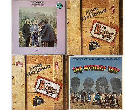
THE BEATLES - LP/ CD BOX SETS. An excellent collection of 9 LP/ CD box sets by The Beatles. Titles include The Mystery Box (Not a CD set, includes booklet, tour bus number plate sticker, route map etc), From Liverpool: The Beatles Box (8 LP set), From Liverpool: The Beatles Box (8 cassette set), The Beatles (CID 10), The Revolver Sessions (Contains CD and book of photographs by Robbert Freeman) A One Way Ticket To Ride (Contains a copy of Help and a book of images by Robert Freeman), The 1967 Sessions, The 1993 World Tour Rehearsal Session & The Complete BBC Sessions (8013013932628, 9 CD set).


Lot 600
FOUR BOXES AND LOOSE METALWARES, GLASSWARE AND CERAMICS, including a plastic sunburst quartz clock retailed by H Samuel, a metallic colour print of a map of Britannia, cottage ware biscuit barrel, teapot and sugar bowl, Continental porcelain pierced rim plates, small blown glass animals and birds, modern silver plate, etc (4 boxes)
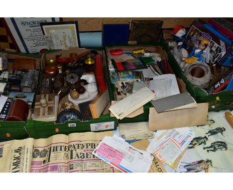
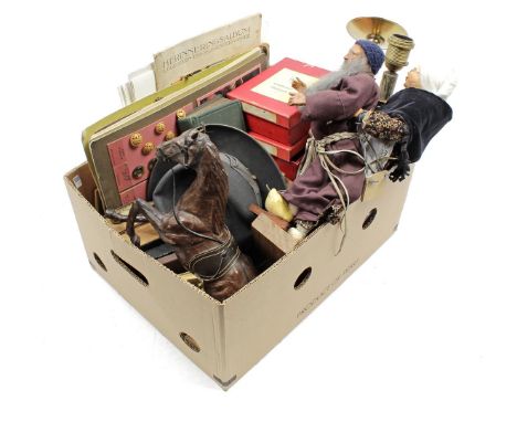
Lot 530
FOUR BOXES AND LOOSE EPHEMERA, GAMES, RUSSIAN INTEREST AND SUNDRY ITEMS, to include painted Russian wooden pots and spoons, a marble eagle dish, decorative wooden clogs, a small marble ashtray, Russian newspapers from the 1980s and early 1990s, guidebooks, souvenirs, tickets and postcards, a sealed 2012 Queen Elizabeth II Diamond Jubilee Waddington's jigsaw, games to include Rummikub, Triominoes, chess, Computachess II, dominoes and darts, a cased leather clothes brush set, two M Hohner harmonicas, a wooden easel with a laminated map of Western Europe etc (sd) (4 BOXES + LOOSE)


Lot 526
° Wilson, The Rev. John Marius - The Imperial Gazetteer of Scotland; or Dictionary of Scottish Topography… 2 vols, each with an illustrated title page, complete with 58 illustrated plates ( many are coloured and some double page ) plus a folding coloured map of Scotland. Half morocco and calf with gilt panelled spines and letters direct. Sprinkled edge papers. 4to. A. Fullarton & Co., London and Edinburgh, [c.1870].

Lot 533
° Grote, George - A History of Greece; from the Earliest Period to the close of the Generation Contemporary with Alexander the Great. A new edition. 10 vols. Complete with an illustrated plate, a folding map and 12 plans (of which 9 are folding). Gilt panelled calf with large gilt armorial to upper, gilt panelled spines with 2 morocco labels. Marbled edge and end papers. 8vo. John Murray, London, 1888.


Lot 626
Travel. Asia. Yule, Capt. Henry - A Narrative of the Mission... To the Court of Ava in 1855. London: Smith, Elder & Co. 1858. With frontispiece, 23 plates and 3 maps plus a folding map loosely inserted. Together with; three titles from the 'Oxford in Asia Historical Reprints' series, and a selection of Hakluyt Society volumes. From the collection of Prof. Hugh Russell Tinker.(10) Condition report: This copy of Yule with 27 of 29 plates, maps, etc. This copy lacking plates number 15 & 17. Hakluyt Peter Mundy Travels volumes are Volume III parts 1 & 2 (Series II, vols. XLV & XLVI)
Lot 644
Railways. Bradshaw's Guides and Companions. Includes; Railway Companion (1846); Monthly Railway and Steam Navigation Guide (1843); Railway Manual (1868); Continental Railway Guide (1890); and a bound Bradshaw's Railway Map (c.1892) with a 1906 edition inserted in pocket. (5) Details: Railway Companion (1846) - Two folidng maps, one folding gradient chart, 13 double page and 2 single page maps (numbered 40-54) Monthly Guide (1843) - linen backed folding map Railway Manual (1868) - no maps Continental Railway Guide (1890) - no maps


![Antiquarian Map. Magni Mogolis Imperium [Mughal Empire]. F. De Witt - Amsterdam - no date, originally published circa 1740. O](https://cdn.globalauctionplatform.com/09233e4f-74ef-454d-a48c-ae1400ccb8aa/86c7f12b-5e5e-4cbd-b491-ae210132102a/468x382.jpg)
![Antiquarian Map. [Richard Blome] - Westmorland. Outline colour. Framed and glazed. (1)](https://cdn.globalauctionplatform.com/09233e4f-74ef-454d-a48c-ae1400ccb8aa/6394a81c-c8e5-46a7-bae2-ae21013211f8/468x382.jpg)

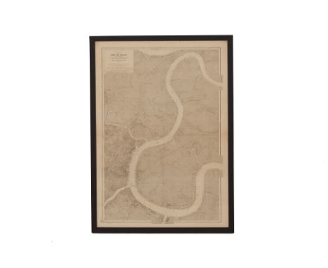
Lot 153
A LARGE FRENCH MAP OF SAIGON PORT, 1936 "Cochinchine, Port De Saigon" Collected from 1931 - 1934 under the successive direction of M.M. A. Gougenheim, P. Gerson, A.Brunel and H.Legrand, hydrographic engineers, 1:7500 scale 105cm x 74cm; with frame 111cm x 80.5cm Condition: Minor signs of wear commensurate with age and use Provenance: Property from an Emerald Hill shophouse, the home of the interior designer behind ‘Galerie Cho Lon'


-
109182 item(s)/page