We found 109182 price guide item(s) matching your search
There are 109182 lots that match your search criteria. Subscribe now to get instant access to the full price guide service.
Click here to subscribe- List
- Grid
-
109182 item(s)/page


Lot 1328
Robert ROWE - A New Map of England and Wales . . . coloured & folded on linen, 66 x 54cms., engraved key, in original slipcase. 1821. * turnpike & other roads, canals etc.; sold with a large-scale plan of Brighton & Hove, cut & mounted on 13 folded leaves within cloth covers. (no title or publisher's name etc. retained, ca. 1880)


Lot 1438
BIBLE - The Holy Bible, Containing the Old Testament, and the New . . . 1613 / 1614, Authorised Version. engraved pictorial general & NT. titles (with the heart-shaped printed centres), head & tailpiece decorations & some initial letters, black-letter & d-column; earlier 19th cent. half calf & marbled boards, gilt-decorated spine, 4to. imprinted at London by Robert Barker . . . 1613 & (NT.) 1614. * with the 'Two Right Profitable and Fruitfull Concordances . . . collected by R.F.H.' (1615) as issued with this edition; the Genealogies & Map (sometime found with this edition) are not here present; the work is preceded by a Book of Common Prayer (1615) & has a Sternhold & Hopkins Psalmes (1621) at end; Darlow & Moule 331A. Illustrated

Lot 1445
BIBLE - The Newe Testament of our Saviour Iesus Christe, faithfully translated out of the Greke, with the Notes and Expositions of the darke places therein . . . (1566 revised Coverdale version). title printed in red & black & woodcut portrait (Edw. VI) within decorative surround, a map, num. engraved text illus. & decorated initial letters, black-letter text; old blind-ruled calf with later gilt-decorated & lettered panelled spine, 4to. (imprinted at London . . . by Richard Jugge . . . 1566) * the third Jugge edition; booklabel of the Baptist College, Bristol & the armorial bookplate their great benefactor, Dr. Andrew Gifford ; Darlow & Moule 121. Illustrated

Lot 167
Walters (Stephen), (Intro), The Voyage of the Bounty Launch, John Fryer's Narrative, signed, no.92 of ltd edn of 500, fldg map, hf mor gt, 4to, slip case, 1979; Bligh (William), Bligh's Narrative of the Mutiny Aboard HM Ship Bounty, no.396 of 1000, 2nd vol of Australiana Facsimiles and other volumes on the Mutiny on the Bounty and Pitcairn Island.

Lot 170
Camden's Britannia - an extract, pp199-208 'Denshire' with dp hd col map by William Kip, rebound cf gt, fo, nd, (1610), together with two other bound extracts: Moule (Thomas), The English Counties, pp 281-340, 3 engr plts, re-backed cf gt, 4to and Grose (Francis), The Antiquities of England and Wales, pp61-70, 51-52, 4plts, mor gt, 4to, [1787], (3).

Lot 173
Izacke (Richard), Remarkable Antiquities of the City of Exeter, 2nd Edn Now Very Much Enlarged and Continued to the Year 1723 by Samuel Izacke, engr frontis, fldg map, replaced view of Exeter Cathedral, armorials in text, re-backed, cf gt, 8vo, 1724 and Prince (John), Danmonii Orientales: or The Worthies of Devon, engr port frontis, plts, cf gt, 4to, 1810, (2).


Lot 182
Paterson (Daniel), A New and Accurate Description of all the Direct and Principal Cross Roads in Great Britain, fldg engr map, 12mo, 1772 and Cary (John), Cary's New Itinerary: or An Accurate Delineation of the Great Roads.... England and Wales, 5 fldg engr maps, re-backed, hf cf gt, orig bds, 12mo, 1810, (2).

Lot 183
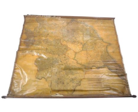
Cary (John), Cary's New Map of England and Wales with Part of Scotland on which are carefully laid down all the Direct and Principal Cross Roads, The Course of the Rivers and Navigable Canals, ........ 1st Edn 1794, engr map with hd col outline, sectionalised and laid on three linen sheets, each sheet with hd col key plate to verso and in 27 sections, overall size approximately 228 x 180cm, contained in modern cloth-covered slip case with facsimile tp, 4to, 1794.


Lot 761
A John Speed county map engraving, Cumberland, showing Carlile (sic) and 'Many Memorable Antiquities', including The Picts Wall (Hadrian's Wall), in double-glazed frame showing text on reverse, impression size 39 x 51 cm, framed and glazed Condition Report Light foxing and age discolouration, no tears


Lot 763
A 17th Map engraving by Herman Moll, 'Great Tartary/with the Tract of the Moscovite Ambassador's travels from Moscow to Pekin in China/Above 4,600 Eng.Mi./By H.Moll Geographer.1732', 20 x 27cm, mounted, framed and glazed Condition Report light foxing, principally at edges, crease top right areas of foxing and paper deterioration; it has not been possible to take this map from the frame.


Lot 124
Le Rallye A‚rien et les Canots - Automobiles. Organised by the International Sporting-Club of Monaco, this is a programme of the 1914 event held on the 1-20 April in Monaco, square-backed with card covers, 72pp, 8vo. The booklet includes a good number of photogravure style photographs of speeding boats, flying aircraft, personalities, list of prizes, list of competitors and a fold-out list of boats and a map of Europe showing flight paths. The cover in good condition, albeit a little scratched and rubbed, the pages tight to the spine, editorial very good (1)
Lot 132
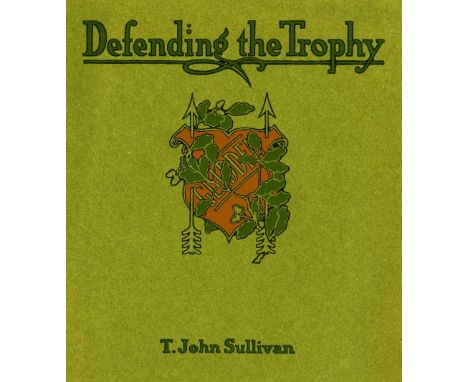
Pierce-Arrow. A circa 1907 promotional booklet, 'Defending the Trophy', by T. John Sullivan, effectively describing the success of the Pierce-Arrow winning the Glidden Trophy (400 ounces of sterling silver) for the second year running. A saddle-stitched 46pp book with good photographs of the competing cars, map of the 1906 event, detailed text, predicaments and troubles and a picture of the trophy. Sound condition, the cover with edge bumps, a company rubber stamp on the front free end-paper (1)

Lot 352
Ford Motor Company Exports. A presentation photograph album relating to Ford Motors in Portugal, circa 1936, a total of 11 gelatin silver print photographs, each mounted to album leaf rectos with captions printed in gilt, photographs signed by the Portuguese photographer to lower margins, each 15.5 x 22 cm, captions include 'Interior of Ford stand', 'Exhibition of 1936 and Lincoln Zephyr', 'General view of Workshop and Super Service Station, Property of Messrs. Manuel Alves De Freitas & Ca', 'Tool and Appliances at Ford Super Service Station', 'Car Washing and Lubricating Department', folding plan pasted to rear inside cover, contemporary boards, lower board detached, spine worn and upper cover deficient, together with a second album relating to Ford Motors in Istanbul, Turkey, circa 1930s, containing 30 mounted photographs (including map), showing Ford Motor Company Export Inc., Istanbul, and related photographs of assembly line and works, etc., embossed stamp 'Femina' to corners, most with neat English white china ink captions to mounts, images 17 x 22.5 cm, mounted to rectos and some versos of stiff card leaves, contemporary cloth-covered boards, upper cover detached and lower cover split, both oblong folio (2)
Lot 116
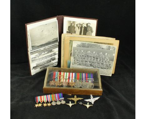
A good WWII Parachute Regiment medal group awarded to 14397885 Private L H Wood of the Army Air Corps Comprising 1939-40 star, Africa star with 8th Army bar, Italy star, France and Germany star, Defence medal, 1939-45 medal, General service medal with Palestine 1945-48 bar together with matching miniature group, together with a photograph of the first Independent Parachute Platoon Parachute Regiment, around the edge Private Wood stated where he served, England December 1942, April 1943 North Africa, June 1943 Sicily, September 1943 Italy, August 1944 Southern France, October 1944 Greece, 1944 Ugos and Cairo, July 1949 Blighty then onto Palestine, also in this lot photograph of Private Wood in his uniform, campaign clasps and medal list, Parachute Regiment old comrades association card, further photograph of the First Independent Pathfinder Platoon with note 'More actual parachute operation than anyone in the Parachute Regiment', map of France, photo album with inscription 21st Independent Parachute Pathfinder Platoon 2nd Independent Brigade, First Division, containing approx 59 photographs, scenes to include parachutists preparing to take off, scene of a parachutists exiting an aircraft, in the air, landing, scenes of preparing to invade Greece, Greek prisoners, pictures of General Alexander, General Mark Clark in Italy, Liberation of Athens, preparing to jump into Baghdad, a group of gentleman believed to be the committee who signed the peace, bombed buildings, gruesome scenes of bodies being pulled out of a well, also National Identity card, Soldiers pay book, release book and release certificate, also additional photographs, also with this lot four parachute regiment badges one in white metal, a lapel parachute badge
Lot 118
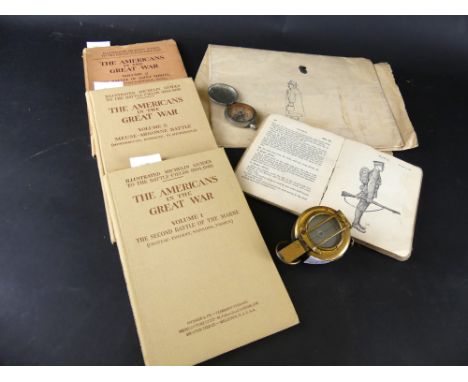
A WWI United States of America white metal compass dated 1917Further British Mk 3a compass dated 1940, the Americans in the Great War in three volumes to include 'The Second Battle of the Marne', 'The Battle of St Mihiel and Meuse-Argonne Battle' published by Michelin & Son 1919, A British Infantry training book dated 1914, large fold out Chinese map circa 1940, verso with sketches of man cleaning a floor, standing man etc

Lot 127
^Two suitcases containing numerous WWII period officers accoutrements To include leather Sam Browne belt with sword attachment, revolver holster, cartridge case, three pairs of spurs and attachment chains, camper bed, leather covered swagger stick, boots, water bottle, balaclava, gaters, kit bags, leather map case, leather gaters etc, also a copy of 'Gliding into War' by Ian & Celia Toler, signed by the author, also three pages of facsimile photographs of soldiers in training dated 1941

Lot 175
A Royal Fusiliers burr maple cigarette box, with hinged lid to decorated interior with three emblems of the regiment, cat, eagle and four leaf clover, a WWII map case, a red canvas belt and a leather sword case and a leather and canvas travel bag for Major John Oliver-Bellasis Royal Fusiliers


Lot 200
An RAF Benevolent Fund bell cast from a German aircraft, sundry WWII and later printed ephemera, ARP tunic buttons, etc., the bell cast from metal from a German aircraft shot down over Britain 1939-1945, together with a Home Guard service certificate, Prince Edward's Farewell to the Nation speech, Ministry of Information leaflets, National Service guide, Daily Express War Map of the Western Front, Ration and Clothing Books, postal history, photographs, 'Thumbs Up' pop-up card, etc.


Lot 561
Johannes Blaeu (Dutch, 1596-1673): a map of Rutlandia, dated 1647, with hand colouring, and decorative coats of arms and cartouches, with text verso, 47 by 57cm, together with a framed bookplate, circa 1600, hand coloured, with The Arms of the Town of Okeham, and Roman coins depicted, 30 by 37cm. (2)

Lot 569
Christopher Saxton / William Kip: 18th century Huntingdon map, uncoloured, 28 by 34cm, together with Robert Morden, (1650-1703) a 'Darbyshire' map, hand coloured, published by Swale, Awnsham and Churchill, 37 by 42cm. (2)Provenance: The Estate of Mr Joseph B. Hay, son of Major-General Arthur K. Hay DSO OBE - 100 years of a military family.
Lot 632
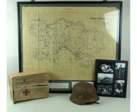
WWII Jersey Occupation: an unusual map of Jersey with handwritten notes pertaining to parishes for the German Army priest, glazed and framed, 95 by 85cm high, together with a WWII German helmet from Jersey, 23 by 28 by 18cm high, and a Canadian Red Cross cardboard box, from the 'Vega', a Red Cross humanitarian vessel which visited Jersey during the end on WWII to deliver much needed aid, 23 by 32 by 13cm high, and photographs of the Red Cross ship Vega, 28.5 by 34cm. (4)


Lot 120
Canadian Forces Navy Air Force hat box, carved wooden crest mounted on wood frame 'Royal Canadian Mounted Police' with name plaque M D Jones 16 Troop 1977/78, two mounted plaques 'Canadiam Forces Exchange' and one other and mounted map of Germany on wood plinth with name plate 'Auf Wiedersehen Mr Jones Mar 77 - Sept 90' and old camera case


Lot 507
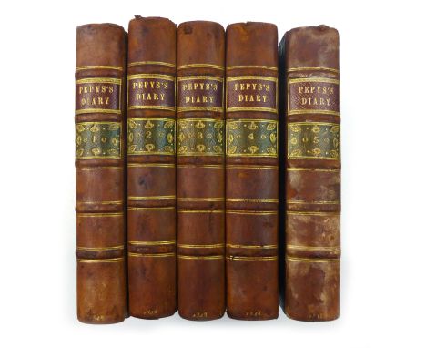
Diary and Correspondence of Samuel Pepys, F.R.S., Secretary to the Admiralty in the Reigns of Charles II and James II. With a Life and Notes by Richard Lord Braybrooke. Third Edition. 1848. Vols 1 - 5 ( Complete ). 8vo. Hb. Full panelled calf with, ribbed spines with maroon & olive labels, gilt. Vol. 1 has frontispiece portrait of Pepys & a fold-out illustration of Pepys handwriting and code for his diary. Vol. 2 has frontispiece portrait of Elizabeth Pepys. Volume 3 has fold-out frontispiece view 'View of the Interior of Mr. Pepys Library in York Buildings.' Volume 5 has a fold-out map of 'scheme of the Dutch fleet'. CONDITION REPORT: Bindings have been professionally re-backed and are a little worn and rubbed at the ext. but sound. Some minor sporadic foxing.
Lot 584
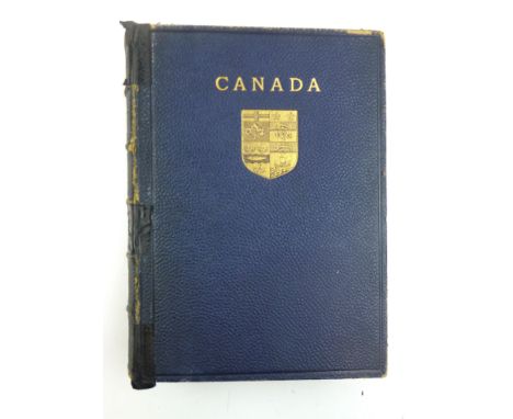
Canada ( A & C Black 'Beautiful Britain' Series - a Colonial edition! ). 1907.'Royal Canadian' Limited edition of 1000. Qto. Hb. Colour frontis & 76 full page colour plates with titled tissue guards, rear folding map, original full blue morocco leather, teg, gilt titles, raised bands, decorations in the panels and front board. CONDITION REPORT: Front hinge splitting o/w vg.
-
109182 item(s)/page