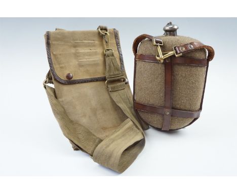
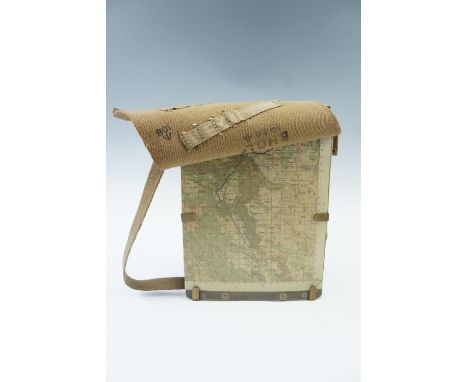
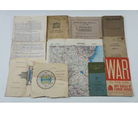
We found 108737 price guide item(s) matching your search

Refine your search

Year

Filter by Price Range
  • List
  • Grid
  • 108737 item(s)
    /page

Lot 51

CLASSIC MALTS 6 MINIATURE SETLagavulin 16 Year Old White Horse - 43% ABV / 5clGlenkinchie 10 Year Old - 43% ABV / 5clOban 14 Year Old - 43% ABV / 5clTalisker 10 Year Old Map Label - 45.8% ABV / 5cl Dalwhinnie 15 Year Old - 43% ABV / 5clCragganmore 12 Year Old - 40% ABV / 5cl"A QUALITY GIFT FROM SCOTLAND" 3 MINIATURE SETBlair Athol 8 Year Old - 70° Proof - Approximately 5clBell's Extra Special - 70° Proof - Approximately 5clDufftown-Glenlivet 8 Year Old - 80° Proof - Approximately 5clPlease note the Classic Malt set fill levels are all below shoulder, as is the Blair Athol. General wear and tear to packaging.

Lot 1283

34 book plates of English country houses, castles, etc., and map of England, taken from "The Modern Universal Traveller 1789"

Lot 597

A Great War period army officer's Sam Browne water bottle together with a similar map case and shoulder strap

Lot 601

A 1944 dated British army webbing map case

Lot 641

Sundry items of military ephemera including a programme of the Pickering War memorial 1914 - 1918 Unveiling Ceremony, HMS Raleigh handbook, an Identity Card cover, 1929 Army Notes on Map Reading etc

Lot 643

A group of Great War ephemera including a Waterproof Carrier Envelope, a map of Lens, a trench map etc

Lot 675

W [William] Wallace, Alston Moor, Its Pastoral People, its Mines and Miners, from the earliest periods to recent times, Mawson Swan and Morgan, Newcastle Upon Tyne, 1890, first edition, 8 plates, folding map (repaired and torn), original cloth gilt boards and spine

Lot 678

Public bills / notices relating to an 1820 election in Westmorland, [including those demonstrating Henry Brougham's, ultimately unsuccessful, struggle to oust the Lowther family], together with later maps relating to Carlisle, a 1940 wartime O.S. map of Hexam, 19th Century hand drawn mine maps, and an 18th Century indenture

Lot 692

T. Donald and J.H. Fryer, "Cumbria County Map", "To the Nobility, Gentry, Clergy and Freeholders of the County of Cumberland, this Map is most Humbly Inscribed by their Most Obedient and Devoted Servant, Joseph Harrison Fryer" Surveyed between 1770 and 1771 by Thomas Donald, made by J.H. Fryer 1818, dissected into panels 30 x 54.5 cm and laid on linen, cloth boards, 58.5 x 32 cm.

Lot 335

AN AIR NAVIGATORS LOG BOOK AND CLOTH MAP, A ROTARY BOOKCASE OF SHAKESPEARE PLAYS, A BRONZE FIGURE AND A MR PUNCH TERRESTIAL GLOBE

Lot 562

AN INTERESTING GROUP OF UNFRAMED WORKS INCLUDING AN EARLY MAP AFTER JOHN SPEED OF THE WELSH COAST. TOGETHER WITH A FRAMED INDENTURE AND VARIOUS PRINTS

Lot 565

AFTER J BLAEU. AN ANTIQUE HAND COLOURED MAP OF DORSET. 41 x 53cms TOGETHER WITH A LATER MAP OF NORTHAMPTONSHIRE BY J. CARY (2)

Lot 585

AFTER J. CARY. ANTIQUE HAND COLOURED MAP WARWICKSHIRE. 54 x 42cms. TOGETHER WITH A PAIR OF LANDSCAPE WATERCOLOURS AND OTHER DECORATIVE PICTURES

Lot 595

FW. ELTON (19th/20th C. ENGLISH SCHOOL) A COUNTRY PARK, SIGNED, WATERCOLOUR. 16 x 26cms. TOGETHER WITH AN ANTIQUE HAND COLOURED MAP OF IRELAND AFTER S. HALL (2)

Lot 391

Jacob van Meurs (Dutch, 1619/20-1680), Africae Accurata Tabula, coloured map of the African continent with illustrations of wild animals, 43 by 54cm, framed

Lot 17

A Large England and South West map from St Ives to Dorman point in wooden frame. W:123cm x H:73cm

Lot 1058

A desk globe together with a laminated wall map of Europe, 110cm x 100cm

Lot 300

SELECTION OF MILITARY MEMORABILIAincluding British, German, American and Russian items such as German First Day Covers; a map of Leningrad; small autograph/scrap book; The 2nd Battalion Gordon Highlanders 1914 Cairo photographic book; 'Glasgow A City at War' by Brian D Osborne and Ronald Armstrong; 'Ten Chapters' journal; 'Aircraft of the Royal Air Force' and 'R.A.F Badges' John Players cigarette card albums; 'Flying Simply Explained' by Malcolm Logan; The War Illustrated No.110, 111and 112; The Scottish Soldier's Hymnal; a Soviet Union Communist Party Membership card; letters and postcards, etc.

Lot 305

WWII GERMAN PISTOL HOLSTERin black leather with a belt loop and stamped with the Reichsadler and bdr41 to the back, a German black leather map holder with two adjustable belt straps with two internal divisions and four pen pockets, stamped to the back 42/6, with two other worn stamps, and a brown leather belt and shoulder webbing (3)

Lot 1008

Ordnance Survey Map of Sheffield Centre 1935, cutlery 'Bezique;' card game etc:- One Box.Lot 1008 - complete but dog eared edges, no ink or pen marks, Yorkshire (West Riding) Sheet CCXCIV, 8 scale 1 to 2500.

Lot 1014

John Speed XX Century Reprint Map 'The Counties of Nottingham', two others. (3)

Lot 1594

An Early XX Century Oak Arts and Crafts Mantel Clock, with a circular dial, Arabic numbers, copper mounts, brass plaque, 32cm high; R, Martin 81, watercolour of Fishing Boats, framed handkerchief, The Absent-Minded Beggar, music by A Sullivan, Queen Victoria, map of South Africa. (3)

Lot 343

An Early Framed Indenture together with a pair of architectural prints and a coloured map

Lot 90

A Robert Morden map of Monmouthshire, hand coloured

Lot 36

Railwayana - A vintage London, Midland And Scottish Railways scroll map, Diagram Shewing Collieries Connected Therewith.

Lot 1053

A framed map of the Dordogne 69cm x 59cm

Lot 77

A collection of 8 finely framed Wine, Maps and Whisky prints and posters including a set of Four prints by Marcel Jeanjean comprising : Framed (glass missing) ‘Wines from Spain’ Map of Denominations of Origin 94 x 79 cms.Framed Ponder Estate Wines ‘French Oak’ Print 65 x 91 cms.Framed Limited Edition (271 of 500) The 1985 Taylors Port Vintage at Quinta de Vargellas signed by Willie Rushton 67 x 38 cms.Framed ‘Classic Malts of Scotland’ Six of Scotland’s Finest Malt WhiskiesFramed Set of Four prints by Marcel Jeanjean (i) ‘La Plantation de la Vigne’ (ii) ‘La Vendange’ (iii) ‘Le Pressoir’ (iv) ‘Le Cellier’ £80 – 100

Lot 171

map of the Territory of Frankfurt dedicated by Joan and Cornelis Blaeu to (translated) "The most noble, most magnificent and most prudent lords, the sheriff, burgomasters, aldermen and councillors of this famous city and republic of Frankfurt, most distinguished, most friendly and most incorruptible men, to these their lord protectors, with humble reverence.", the map with 34 coats of arms of the magistrates of Frankfurt depicted around the edge, above the map are personifications of justice (Justicia), Counsel (Consilium), Unity (Concordia) and Peace (Pax), the first with the arms of the Holy Roman Empire and the last with the arms of the city of Frankfurt, From: Theatrum Orbis Terrarum.. J. Blaeu, 1649-55

Lot 173

John Speede Engraved Map of Surrey Described and Divided into Hundreds, pub. 1611, with hand-coloured armorial crests and borders, 38.5 cm x 51 cm, framed & glazed.

Lot 174

Noorthouck (John). A New PLan of London Westminster & Southwark Engraved for the Noorthoucks History of London 1772, 42.5 cm x 71 cm, framed & glazed; plus Kitchen (Thomas) A Map of Countries Thirty-Miles Round London - Drawn and Engraved from Accurate Surveys by Thos Kitchin Hydrographer to His Majesty 1773, handcoloured 53.5 cm x 49 cm, framed and glazed (2)

Lot 193

Mandela (Nelson) Long Walk to Freedom, one of 250 copies signed by the author to limitation page, pictorial map endpapers, original green morocco, gilt, slip-case, 8vo, 1994.

Lot 196

Milne (A. A.) [The Christopher Robin Books], 4 vol., comprising When We Were Very Young, fifth edition, light browning to endpapers, spine ends and corners a little bumped, jacket spine a little browned, foxing and light surface soiling, light creasing and a few nicks and teas to head and foot, 1924; Winnie-the-Pooh, second edition, light browning to endpapers, jacket with very light toning to spine, short tear to foot of upper panel, some light creasing to head, 1926; Now We Are Six, first edition, light browning to half-title and imprimatur, jacket with light toning to spine, short nick to head of upper joint and corner, 1927; The House at Pooh Corner, first edition, light browning to endpapers, jacket with light sunning to spine, light creasing to spine head, 1928, pictorial or map endpapers, original pictorial cloth, gilt, some slight shelf-lean, light rubbing to spine tips and corners, t.e.g., dust-jackets, an excellent set, 8vo.⁂ An attractive set, the first two titles with dust-jackets matching those usually found on the first editions.

Lot 212

Tolkien (J.R.R.) The Hobbit, or There and Back Again, first edition, first impression, frontispiece, one plate and 8 illustrations, including 7 full-page, map endpapers printed in red and black, all by the author, 2pp. advertisements, Time Book Club book label to rear pastedown, some light spotting to half-titles and endpapers, light spotting to fore-edge, original pictorial cloth, shelf-lean, light toning and faint spotting to spine, spine ends and corners a little bumped, very small patch of fraying to lower edge, but a bright and excellent example overall, 8vo, 1937.⁂ An unusually bright example of this landmark children's fantasy novel.

Lot 213

Tolkien (J.R.R.) [The Lord of the Rings], 3 vol., first editions, first impressions, folding map at end of each volume, "signed" J.R.R. Tolkien in an unknown hand, not that of the author, modern red calf, gilt, spines gilt in compartments with orange morocco labels, some light toning to spines, but generally excellent, 8vo, 1954-55.⁂ Return of the King with signature mark '4' and text block sagging.

Lot 249

Canada.- [Maseres (Francis)] Additional papers concerning the Province of Quebeck, first edition, engraved hand-coloured map "Quebec and its Environs" dated 1813 laid onto title verso, 2 other Quebec plates loosely inserted, lacking final blank f., title with some show-through from glue on verso with contemporary ink ownership inscription and ink stamp, occasional light browning, modern morocco-backed boards, [Sabin 45411], 8vo, W. White, 1776.

Lot 258

Crete.- Pashley (Robert) Travels in Crete, 2 vol., first edition, half-titles, 10 lithographed plates, folding map and plate of inscriptions, wood-engraved illustrations, some full-page, occasional ink and pencil notes to margins, 1 or 2 additional illustrations laid onto blank margins, vol. 1 title remains of adhesive strip to inner margin, bookplate and ink ownership inscriptions to pastedown and endpapers, original cloth, light sunning to spines, spine ends and corners a little bumped and frayed but a good set overall, [Blackmer 1263; Not in Abbey], 8vo, Cambridge & London, 1837.⁂ "First edition of this important work... Pashley spent most of 1834 in Crete, exploring it in detail. He was accompanied by Antonio Schranz, a member of the Maltese family of artists, who did the drawings... Pasley and Schranz visited practically every village, monasteries, ancient sites, etc. and have produced a detailed account of the island." - Blackmer.

Lot 263

Mediterranean.- Arabic inscribed maritime pilot.- Colom (Jacob Aertsz) [Colomne Ardante de la mer Méditerranée], 9 double-page maps only, 8 by Colom, numbered in the plates from '2' to '9', plate '1' replaced with Johannes de Ram's map of the Mediterranean 'Paskaart vande Middelandsche Zee In twee deelen vertoont...', charts 2 to 9 cover the Straits of Gibraltar, the Barbary Coast, Majorca, the coastline around Barcelona, Nice, Corsica, Sardinia, Southern Italy, Sicily, and Croatia, engraved charts, each sheet approx. 440 x 550 mm (17 1/4 x 21 3/4 in), each mounted on stiff paper with maps back-to-back, with thick red and black ink borderlines, Arabic inscriptions translating location names throughout, heavy spotting and browning throughout, some cockling and losses to sheets, old repaired tears, creases and signs of heavy use, contemporary stiff paper covers, worn with losses, maunscript label to lower cover pasted upside down that reads 'Carta Marinaresca/ del Mar Mediterraneo', folio, [Amsterdam, circa 1670-1680]⁂ Unusual working copy of Colom's rare pilot, owned by a mariner fluent in Arabic. Koeman highlights the rarity of Colom's pilot books and notes that despite 'thousands of copies [being] circulated [...] only a score have survived'. [Koeman IV, p. 120]

Lot 271

Voyages.- Schouten (Willem Corneliszoon) Journal ou Description du Merveilleux Voyage...en circum-navigeant le Gobe terrestre..., second Amsterdam edition in French, engraved title-vignette, double-page engraved twin-hemisphere world map supplied from another edition with Dutch text to verso, 3 other folding engraved maps (one with a few small repaired holes at old fold), 5 engraved double-page or folding plates (at least 3 from another edition with Dutch text on verso), C3-D1 with very slight worming in text, later calf, gilt, corners and spine ends worn, rubbed, [Sabin 77948; Hill pp269-270], 4to, Amsterdam, Chez Harman Ianson, 1619.⁂ A good, albeit sophisticated, copy. "This is the account of Schouten's voyage around the world, during which Cape Horn, named after Schouten's native town [Hoorn], was discovered, and first rounded. The leading citizens of Hoorn had helped finance the expedition by joining together under Isaac Le Maire to found the Compagnie Australe. The newly-discovered passage to the Pacific Ocean was named the Strait of Le Maire. Although published under Schouten's name, it is not certain that he was the true author of this journal, which was edited and compiled by the mapmaker, Willem Jansz Blaeu. It is probably compiled from one or more of the log books of the voyage and perhaps mainly from one kept by the commissary Aris Claezoom. The ship Eendracht, while crossing the Pacific, discovered some of the Tuamotu Islands, the northern Tonga Islands, the Hoorn Islands, the Schouten Islands, and visited New Guinea, the Moluccas, and Batavia... Several of the maps are of great importance for the history of Pacific cartography. The northern coast of New Guinea was revealed and charted for the first time with some definiteness of detail." (Hill).Provenance: Anselme de Bonnaire (ink name on title and verso, dated 1631); Thomas Philip Earl de Grey, Wrest Park (bookplate); "B.L." (unidentified 20th century bookplate)

Lot 272

British Isles.- Ortelius (Abraham) Britannicarum Insularum Vetus Descriptio, two-sheet map of ancient Britain, probably engraved by Jan Wierix, with four ornate strap-work cartouches, a naval battle in the upper left, and a number of other vessels around the coast, engravings on laid paper with full hand-coloured, two sheets expertly joined, total platemark approx. 725 x 485 mm (28 1/2 x 19 1/4 in), Latin text visible verso, central vertical folds as issued, minor printer's creases, framed and glazed, Antwerp, 1590Literature:VdB 190-191⁂ Excellent example of this two-part map, which only appeared in the early editions, being replaced by a single plate in 1595.

Lot 274

Gloucestershire.- Atkyns (Sir Robert) The Ancient and Present State of Gloucestershire, second edition, large paper copy, double-page engraved map, 8 plates of coats-of-arms and 64 double-page views by Kip, with Author's Epitaph and Directions to Binder f. following preface and advertisement, occasional light spotting or finger-soiling, mostly marginal, some leaves or plates with short marginal tears, some plates creased, otherwise a generally crisp and clean copy, contemporary panelled calf, spine gilt in compartments, lightly rubbed, folio, T. Spilsbury, for W. Herbert [&c.], 1768.⁂ An excellent large paper copy of the second edition. Thomas Kip's views of country seats, first published in 1712, make this one of the best known topographical works of the eighteenth century.

Lot 277

Scotland & Ireland.- Blaeu (Willem Jansz. and Joan) Novus Atlas, Das ist, Weld-beschreibung, Mit schönen newen außführlichen Land-Taffeln in Kupffer gestochen [Volume V. Scotland and Ireland], engraved title with Scottish coat of arms and architectural facade containing letterpress title on overslip, 52 double-page and one single-page engraved maps, all with early hand-colouring, title and maps mounted on stubs, browning, off-setting, spotting and staining throughout, sometimes very heavy to both text and maps, title with heavy surface dirt and browning, marginal tears and rough edges, the overslip with ink inscription from previous owner and area of abrasion to lower right, 'Scotia Antiqua' map trimmed at the right side and lacking panel with cartouche, several maps with splitting to central vertical folds, numerous marginal nicks and small losses throughout, some heavy handling creases, original publisher's vellum panelled in gilt, lacking green silk ties, covers soiled, warped, corners bumped, worn, folio, Amsterdam Joan Blaeu, 1654.⁂ The 'first printed county atlas' of Scotland [Koeman]. German edition of Blaeu's atlas of Scotland and Ireland, comprising volume V of the Novus Atlas.

Lot 296

Birds.- Babington (Churchill) Catalogue of the Birds of Suffolk, first edition in book form, presentation copy inscribed by the author, map frontispiece, 7 plates, occasional foxing, original cloth, John Van Voorst, 1884-86 § Ticehurst (Claud B.) A History of the Birds of Suffolk, first edition, folding map, original cloth, dust-jacket chipped and with piece missing from lower panel, 1932 § Glegg (William E.) A History of the Birds of Essex, first edition, plates, folding map, original cloth, dust-jacket, slightly frayed at spine ends, 1929 § Tuck (Rev. Julian G.) Ornithology of Suffolk, offprint, author's own copy with his ink ownership inscription and numerous ink annotations on interleaves, original cloth, Sheffield, William White, 1891; and 4 others, birds and botany, 8vo (8)

Lot 299

Birds.- Delacour (Jean) The Waterfowl of the World, 4 vol., first edition, 66 colour plates by Peter Scott, 155 map illustrations, vol. 1-3 signed by the artist on front free endpaper, vol. 4 with signed presentation inscription from the author and Peter Scott on front free endpaper, each with an original ornithological illustration by Scott, contemporary blue half morocco by Sangorski & Sutcliffe, gilt, lightly rubbed, spines slightly sunned, t.e.g., [Nissen ZBI 1065], 4to, 1954-64.⁂ The original illustrations are in fountain pen in vol. 1 and 2, and watercolour in vol. 3 and 4.

Lot 3

Solinus (Caius Julius) Polyhistor, Rerum Toto Orbe Memorabilium Thesaurus Locupletissimus, second edition, collation: a6 B4 a-z4 Aa-Ff4, 2 folding woodcut maps by Sebastian Munster (one of which browned, with small tear at fold foot and small hole to blank margin), numerous woodcut illustrations (some whole page), printer's woodcut device to title and final f. verso, book label laid down to title (obscuring previous ink ownership inscription), bookplates, some cracking to gutter (worst at 1C and hinges), several ff. browned, some light marginal browning and damp-staining, contemporary vellum with morocco label to spine, repair to spine head, small amount of worming to spine, [Adams S-1394; Burden 11], folio (c.300 x 194mm.), Basel, Michael Isingrin, 1543.⁂ Munster's double-page map entitled Asia Minor, which appears here as it did in his first edition of Solinus' Polyhistor in 1538, is the earliest printed map focusing on the continent of Asia, and also contains the first printed representation of the Pacific coast of America.

Lot 345

Hills (Robert) Etchings of Red Deer, etched title and 62 plates on 46 sheets, 1812; Fallow Deer Drawn from Nature, etched title and 79 plates on 52 sheets, 2pp. autograph letter from the author to Lady Jackson pasted to front free endpaper, 1813, bookplate of Lord Gwydyr, some scattered foxing, affecting many but not all plates, uniform contemporary diced calf, gilt, rebacked, with original spine laid-down, quite rubbed, a few scuffs and chips at extremities, folio (2)⁂ In his undated letter, Hills discusses the deer in Kensington Gardens, with a sketched map and pencil drawing of a deer beneath trees.

Lot 383

Eiffel (Gustave) La Tour de Trois Cents Mètres, 2 vol., one of 500 copies (numbering not uniform), signed presentation copy from the author inscribed "A l'Institution of Engineers and Shipbuilders in Scotland de Glasgow. Hommage de G.Eiffel" on half-title of vol.1, etched portrait (spotted), titles in red & black with vignette, text with illustrations, 2 leaves of facsimile signatures and appendix at end, plate vol. with 53 double-page lithographed or chromolithographed plates numbered I-XLVII as called for (with 8 additional plates but XXVI & XXVII never printed), a few with folding leaf of explanatory text, 13 photogravure plates, 11 double-page, double-page colour map of environs of Paris, all mounted on stubs, text volume lacking pp.181-185, library stamp to titles but an excellent copy, contemporary half morocco, t.e.g., rubbed, particularly joints, spine ends repaired, preserved in modern cloth slip-cases, folio, Paris, 1900.⁂ Magnificent account of the construction of the famous Eiffel Tower, built in 1887-89 for the Universal Exposition in Paris of 1889, and one of the earliest monographs dedicated to a modern building. It was produced at Eiffel's expense for presentation to libraries, institutions etc.

Lot 89

Sale (George, translator) The Koran, Commonly called the Alcoran of Mohammed, first edition of this translation, title in red and black, folding engraved map of Arabia and plate & plan of Mecca, 3 engraved genealogical tables (2 folding), signature cut away from head of title, map torn and neatly repaired, slight worming (mostly single wormhole but developing into a track towards end, generally a good clean copy, book-label and bookplate of E.Lloyd of Rhagatt, contemporary panelled calf, a little rubbed and marked, rebacked with gilt spine, [Rothschild 1811], 4to, C.Ackers, for J.Wilcox, 1734.⁂ The first translation into English directly from Arabic, and a landmark in Quranic studies.

Lot 602

A 1935 London bus map, Central Area no.4

Lot 21

COLLECTION OF MAINLT BRITISH ANTARTIC TERRITORY COVERS and stamps including two South Georgia set as originally issued on cover (no £1 black), BAT 1963 set as originally issued to £1 map x 3 and set to £1 ship (less £1 map) x 2. highly catalogued and unusual

Lot 47

A BOX CONTAINING VARIOUS MILITARY RELATED ITEMS, to include a small pair of binoculars dated 1915, brass napkin ring with five pointed Star applied, brass tray with Monistir design with mosque and Russian double headed eagle on base, six bags of miscellaneous buttons, Cap badges, Industrial Badges, etc and a copy of the Daily Express War Map of the Western Front

Lot 55

A T.G. & CO LTD LONDON MILITARY COMPASS, this example is in good condition for its age, bears the No.B number 13091, MKII dated 1939, the oil filling still present and appears to be fully working etc, together with a Notes On Map Reading 1929 (reprinted with amendments Nos 1 to 4 1939) (edges of pamphlet worn) (2)

Lot 149

Luftwaffe pilots jacket with zip breast pockets and two flat pockets, inside map pocket, epaulet buttons with authentic 1942 label

Lot 290

Booklets,postcards and ephemera relating to WWII inc. a maintenance manual for Ford Model 2G8T Truck, colored dated events war map c.1944,etc.

Lot 368

Moneybox cannon model, makers name Banthrico Inc. USA, brass US military crest wall plaque and a carved yew wood propeller with map of Australia crest (the Desert Hanna tree)

Lot 71

Two trench art matchbox holders and a trench art snuff box, and a WW1 matchbox embossed with Indian map and script 'Farewell from the Womens Branch Bombay Presidency War and Relief Fund 1914-1918'

Lot 215

After JOHN SPEED (1552-1629) and JOHN NORDEN, a map of Middlesex titled 'Middle-Sex described with the Most Famous Cities of London and Westminster', vignette to lower right reads: 'Solde in Popes head alley againft the Exchange by George Humble', held within double glazed frame with book plate index visible on the reverse, frame size 56cm x 69cm.  Creased vertically down middle of the map. Some small areas of wear. Unusual white strip to the right edge.

Lot 216

After JOHN SPEED (1552-1629), a map of Britain titled 'Britain As It was Devided in the tyme of the Enghfhe Saxons efpecially during their Heptarchy', vignette to middle right reads: 'to be fold by John Sudbury and Georg Humble in Popes head alley at London', held within double glazed frame with book plate index visible on the reverse, frame size 57cm x 69cm.  We believe this to be an original. Please see additional images to answer any further questions regarding authenticity

Lot 218

After JOHN OGILBY, a map of the road from Crookhorn to Plymouth titled 'The Continuation of the Road from London to the Lands-End', plate 3, coloured engraving, frame size 49cm x 63cm.

Lot 219

After TIMOTHY PONT, a map of Edinburgh and the Lothians titled 'A New Description of the Shyres Lothian and Linlitqvo', bears the arms of James I, held within double glazed frame with book plate index visible on the reverse, frame size 55cm x 72cm.

Lot 220

After JOHAN BLEAU, map of the East Neuk of Fife titled 'Fifae Pars Orientalis', frame size 58cm x 70cm and After TIMOTHY PONT, map of the Scottish Borders titled 'Lidalia vel Lidisdalia Regio Lidisdail', held within double glazed frame with book plate index visible on the reverse, frame size 50cm x 61cm, (2).

Loading...Loading...
  • 108737 item(s)
    /page

Recently Viewed Lots