We found 109198 price guide item(s) matching your search
There are 109198 lots that match your search criteria. Subscribe now to get instant access to the full price guide service.
Click here to subscribe- List
- Grid
-
109198 item(s)/page


Lot 551
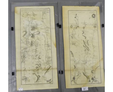
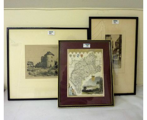
Emanuel Bowen (British, 1694-1767): A map of Lincolnshire, printed by 'Rob Sayers and John Bennett, no 53 Fleet St, et John Bowles, no 13 Cornhill and Barrington Bowles, No 69 St Paul's Church Yard', dated 1777, with title 'An Accurate Map of Lincoln Shire divided into Wapontakes', 51 by 41cm.


Lot 699
(Freeling A. ) : Railroadiana - A New History of England : London and Birmingham Railway, 1838. Small 8vo. Hb. original green cloth, gilt. Folding coloured frontis and other coloured and monochrome plates. Coloured folding map in front pocket. CONDITION REPORT: Binding a little worn at ext. o/w sound. Minor sporadic foxing o/w vg.

Lot 613
Collection of 50+ Manuals of Map Reading, Photo Reading and Field Sketching, early 20th.C. onwards, mainly 8vo Hb. Together with some other Handbooks. Various formats, HMSO Publications CONDITION REPORT: This Lot is part of a substantial collection of books and ephemera consigned to auction by the Imperial War Museum which represent duplicates of items already in their collection. The material covers the 1st. & 2nd. World Wars, other areas of 20th.C. Military History and more general, related subjects. It will therefore bear evidence of this fact to varying degrees in the form of library stamps, booking sheets etc. Evidence of this provenance varies considerably. A number of books have a standard library binding. A substantial number retain the original binding. In the context of its status as an ex-library collection the condition of individual Lots varies - some might be considered 'poor' (though scarce), most are 'good' to 'very good'. Interested buyers/bidders are advised to make their own physical checks on Lots prior to submitting or making bids well before the day of the sale.


Lot 650
Plan of London, W. H. Smith and Son, nd. C. 1878. Folding linen-backed map, hand coloured. 32.5 x 23.5 inches. Map folded into green cloth covers, gilt, with publisher's advertisements on verso of front cover. The map has a colour key to show the river, parks, railway (over and underground lines), tramway and omnibus routes and the postal districts. An early edition of this map which was published over three decades C. 1875 - 1910. CONDITION REPORT: Cover a little worn at the edges but overall very sound. Map with one closed fold tear on upper section o/w generally clean and bright.

Lot 544
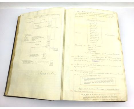
Coal Mining Archive. A substantial and varied collection of items relating to coal mining in various locations including : South Staffordshire Mines Drainage Commission - An original large folio ledger with manuscript and pasted-in printed entries dated between 1901 and 1910; A landscape folio ledger recording General Drainage Rate entries for South Staffordshire Mines Drainage, 1944 -1951; A large folding glazed linen coloured plan of Ketley, Standhills, Tiled-House and Corbyn's Hall Colleries ( Dudley ) dated 1871; Large scale folding map of Sandwich Flats relating to the Kent coalfields and associated railway dated 1907; A large elephant folio folder containing small scale geological and other maps and plans; Sets of mining related volumes including : Coal Mining Series - Surveying, 1953, Vols 1&2, Deputies Manual, 1954, Vols. 1&2, Modern Mining Practice, C.1920, Vols. 1-5, Practical Coal-Mining, 1913. Vols.1,2,3,4 & 6. CONDITION REPORT: Most items in reasonably good condition but inspection is recommended.

Lot 651
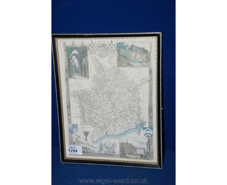
Northamtoniae Comitatus Descriptio in quo Coritani Olim Insederunt . This is an early map of the county of Northamptonshire engraved by William Kip and based upon the famous survey by Christopher Saxton and published in Camden's Britannia. It is fully engraved to illustrate all the salient features of the county including market towns, rivers, castles, forests, parks, hills, and bridges. The map features a strapwork title and scale cartouches, with the names of the county`s hundreds in a key beneath the title. Hand coloured in outline. Nd. C. 1635. Mounted, framed and glazed CONDITION REPORT: Generally vg.

Lot 585
( Hotten J.C. ) : A Dictionary of Modern Slang, Cant and Vulgar Words used at the present day in the streets of London; the Universities of Oxford and Cambridge; the Houses of Parliament; the Dens of St.Giles and the Palaces of St.James. Preceded by a History of Cant and Vulgar Language from the time of Henry VIII and showing its connection with the Gipsey Tongue. Together with Glossaries of Two Secret Languages spoken by the wandering tribes of London, the Costermongers and Patterers. 1859. 1st. Ed. Small 8vo. Hb. Original blind-stamped cloth. Frontis depicting 'A Cadger's Map of a Begging District'. Scarce. CONDITION REPORT: Binding a little worn with slight loss at the head of the spine. Minor and slight sporadic foxing ( particularly noticeable on eps,frontis & tp ) o/w generally vg.
Lot 717
George Philip : The Allies Map of the Western Front - A Detailed Reference Map of Paris to the Rhine. With the Armistice Terms. Nd. C. 1919. Folding,coloured, shaded and annotated map housed within original card covers. CONDITION REPORT: Small tears with slight loss to margins and hinge of cover o/w vg.


Lot 233
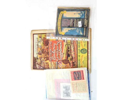
Railway Related Paperwork including LNER 'On Either Side' booklet with map, Southern Railway Fare London-Paris leaflet, SE&CR London Paris Fares leaflet, LNWR Menu card, Metropolitan Railway Debenture dated 1888 and various other items (mostly pre-grouping) including some Continental items and a copy of Northern Echo Railway Centenary Suppliment 1925


Lot 500
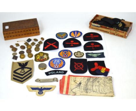
A quantity of military badges to include Naval badges, German badges and a Naval hat ribbon for the Schlachtschiff Scharnhorst ship, a quantity of military buttons to include examples form the king's regiment, a small brass compass, and a small linen map 'Mapa de la Region Amazonica Del Peru'.
Lot 487
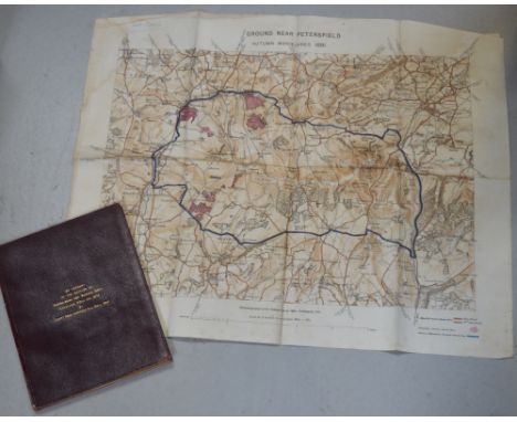
A leather bound account of the battles of Isandlwana and Rorke's Drift, Zululand, 22nd January 1879, by Captn. Penn Symons, 2nd 24th Regt. The account details the battles of Isandlwana and Rorke's Drift from a first hand perspective and subsequently from the few remaining survivors of both battles who are included in the list of survivors of 1/24th Regt; Pte. Williams, groom to Col. Glynn, Pte. Bickley, band member, Pte. Wilson, band member, Pte. Trainer, rocket battery, Pte. Johnson, rocket battery, Pte. Grant, mounted infantry and officers who escaped to include; Capt. Essex 75 Regt., Capt. Gardener, 14th Hussars, Lieut. Cachrane 32 Regt. Lieut. Smith Dorrien, 95th Regt and Lieut. Curling R.A. William Penn Symons (July 1843- October 1899) was a British army officer who lost his life at the battle of Talana Hill during the second Boer war. His first combat was in South Africa during the 9th Xhosa war (1877-78). In 1879 he took part in the Zulu wars which this book documents, the merest chance saved him form death at Isandlwana, also a linen map 'Ground near Petersfield Autumn Maneuvers 1891'. As photozincographed at the Ordnance Survey Office Southampton, 1891. CONDITION REPORT This is a private publication, there are 63 pages.


Lot 1434
PATERSON'S BRITISH ITINERARY . . . the Direct and Principal Cross Roads of Great Britain. 2nd edition improved, 2 vols. double-page general map & 87 leaves of strip road maps (in 386 numbered columns), engraved titles & explanatory letter-press; contemp. calf (distressed). Bowles & Carver, 1807.


Lot 1471
James WYLD - A Map to Illustrate the War in China: compiled from surveys & sketches of British officers . . . 2nd edition. outline colour, 33 x 73cms., 5 insets, folded & mounted on linen, & in original patterned cloth slipcase. (1842). * a detailed map; insets include attacks on Canton & Amoy by British forces - & at the latter, names & stations of warships. Illustrated

Lot 1469
DINSMORE'S Complete Map of the Railroads & Canals in the United States & Canada . . . 65 x 79cms., coloured in outline, engraved title, inset area map, folded on paper into decorated cloth covers. New York, 1856; sold with Wm. Darton's small map of South America (1820), in slipcase; & 3 others. (5)


Lot 1478
Don Thomas LOPEZ - Map of Spain & Portugal . . . 43 x 54cms., hand-coloured in outline, engraved title, folded & mounted on linen, in original slipcase with printed paper label. John Stockdale, 1808; sold with A New Map of Europe (folded, Wm. Darton, 1829, in slipcase); & 2 later maps of Crete. (4)

Lot 1468A
WRIGHT (T.) The Universal Pronouncing Dictionary . . . 5 vols. with num. engraved portraits, plates, & the series of 79 d-page Tallis maps (outline colour); half calf & marbled boards, 4to. (?1850). * the map by Rapkin, with the attractive engraved vignette border illustrations, & 'forming a complete atlas of the world'.

Lot 1482
Thomas HAM - A Map of Australia Felix . . . 48 x 73cms., outline colour, engraved title & references, inset area map, folded on linen into old covers. Melbourne, 1847. * includes the very rare 15pp. key (with numbered squatting districts); 'compiled & carefully revised from the Colonial Government Surveys, Crown Lands Commissioner's & Explorers Maps, Private Surveys, &c.' Illustrated


Lot 1476
James WYLD - Map of the country between Odessa, and Constantinople, embracing the present Seat of War, between the Russians & Turks. 77 x 50cms., hand-coloured, engraved title, insets of Bosphorus, Dardanelles, & another, folded & mounted on linen, within cloth covers. (ca. 1855); John ARROWSMITH The Crimea . . . 52 x 67cms., outline colour, some engraved text, insets of Sebastopol & Black Sea, folded & mounted on linen in cloth slipcase with paper label. 1854.
Lot 1345
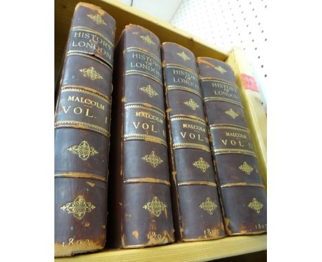
MALCOLM (J.P.) Londinium Redivivum; or, an Antient History and Modern Description of London . . . First Edition, 4 vols. 46 engraved plates; early 20th cent. half calf & cloth, gilt spine, 4to. 1802-07. * EXTRA-ILLUSTRATED with addition of some 380 plates, num. folded & a few hand-coloured (see internet details); also Stockdale's large-scale 'A New Map of the Country Round London' (1796), hand-coloured & folded.Add 255
-
109198 item(s)/page