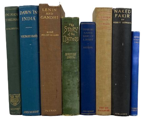

Fourteen works on the history of India. C. F. Andrews (ed). 'Mahatma Gandhi: his Own Story,' first edition, original cloth, some spotting, George Allen & Unwin, London, 1930; Prithwis Chandra Ray. 'Life & Times of C. R. Das. The Story of Bengal's Self-Expression,' first edition, original cloth, unclipped dj, slight spotting to edge of textblock, frontis and plates, Oxford University Press, 1927; Edward Thompson. 'The Reconstruction of India,' first edition, light staining to original cloth, Faber & Faber, London, 1930; C. H. Payne (ed). 'Tod's Annal's of Rajasthan. The Annals of Mewar,' original cloth, fold out map to rear, George Routledge & Sons, London, n.d; Nicol MacNicol, J. N. Farquhar (ed) and H. D. Griswold (ed). 'Indian Thesim. The Religious Quest of India,' review copy stamp to titlepage, original cloth, Humphrey Milford, Oxford University Press, 1915; Sir Francis Younghusband. 'Dawn in India. British Purpose and Indian Aspiration,' first edition, mould spots to original cloth, John Murray, London, 1930; With eight other works on India including 'Lenin and Gandhi', 'Thakore Sahib Shri Sir Daulat Singh of Limbdi, Kathiawar. A Biography', and 'The Indian Chaos'. (14)From the library of Joseph Herbert Thorniley, former editor of ‘The Pioneer’ Allahabad.
We found 109182 price guide item(s) matching your search
There are 109182 lots that match your search criteria. Subscribe now to get instant access to the full price guide service.
Click here to subscribe- List
- Grid
-
109182 item(s)/page

'Field Notes Mesopotamia' General Staff, India. February, 1917. Catalogue No. M. 3, for official use only, faded original envelope wrap, vg folded map to pocket of front pastedown, graphite signature to titlepage off Joseph Herbert Thorniley the former editor of ‘The Pioneer’ Allahabad, good to very good textblock, Superintendent Government Printing, Calcutta, 1917.

(India) Road Map and Government Report. Road Map of the United Provinces of Agra & Oudh, folded map backed onto linen, printed boards, 16 miles to 1 inch, H. J. A. Moore personal assistant to Chief Engineer, Government Press, Allahabad,1927; 'Report of the Committee appointed by the United Provinces Legislative Council to co-operate with the Indian Statutory Commission,' cloth backed printed boards, some spotting to an otherwise vg copy, Government Press, Allahabad, 1929. (2)From the library of Joseph Herbert Thorniley, former editor of ‘The Pioneer’ Allahabad.


Collection of Great Western Railway Books and Journals (16), GWR Railway of England 1837-1927 Quickest Route New York-London via Plymouth Souvenir Booklet, Cheltenham Flyer by Street, The 'King' of Railway Locomotives by Chapman, GWR Railway Engines published by GWR Magazine 1923, GWR Engines (GWR,1938), Track Topics by Chapman, Brunel and After by Williams, Caerphilly Castle by Chapman, Locos of the GWR Part One by RCTS, Part Two Broad Gauge, GWR Progress 1935-1935, Swindon Works and it's place in GW History (GWR 1935), Next Station (Railway plans for the future) by Barman 1947, GWR Magazine Sept 1935, British Empire Exhibition Wembley 1925 GWR Souvenir Book and repro map of GWR Railway , G-VG (16)

A Proliferation of collectable booklets pamphlets and other railway-related paraphernalia (qty), assorted original (marked) and later repro Ian Allan 'ABC' volumes, various repro Hornby and Hornby-Dublo leaflets, Tony Oakes H-D Collector's guides, a modest collection of GWR/Western Region b/w photographs, four LT 'cantrail' line diagrams on paper for Northern (2) and Central (2) Lines, a later Bakerloo version on self-adhesive plastic, several rolled posters including 1974-repro 'Underground - Winter's discontent made glorious', a repro Hornby 'Princess' showcard, tin-printed GWR system map, 3 shets of 0 Gauge advert posters and many other items (qty)

A selection of hardback book and other books, primarily relating to Canada, titles including: A Summer on the Canadian Prairie, by Georgina Binnie-Clark; The Long Labrador Trail, by Dillon Wallace; Canada, by T, Mower Martin and Wilfred Campbell; Canada As It Is, by John Foster Fraser; Canadian Pictures, by the Marquis of Lorne, with map; and others, one box.

A collection of books relating to Scotland, titles including: Rampini (Charles), Shetland and the Shetlanders: Two Lectures, 12vo., full calf, Kirkwall, 1884; Campbell (J. F.), Popular Tales of the West Highlands, vol 4, 12vo., gilt cloth, Edinburgh, 1862; Stark (John), A Picture of Edinburgh, 32mo., gold tooled calf, Edinburgh, 1836; Stark (John), Gazetteer of Scotland, 32mo., cloth and board, Edinburgh, 1805; The Picture of Glasgow, 12mo., half calf with marbled boards, with map, Glasgow, 1812; and others; together with Chambers' Edinburgh Journal, February 4, 1832, unbound. (15)

A selection of hardback and other books, primarily relating to the North East and Scotland, titles including: The Berwickshire Naturalist Club, several volumes; An Old-Time Fishing Town: Eyemouth, by Daniel McIver; Lindisfarne, by Magnus Magnusson; Historic Sites of Northumberland, by Glen Lyndon Dodds; The Scottish Border and Northumberland, by John Talbot White; The Mediaeval Defences of Berwick upon Tweed, by The Border Archaeological Society; The Border Angler, with map, 1858; and others, one box.

A selection of hardback books, primarily relating to Britain, titles including: The English Year: Spring, by Beech Thomas and Collett; The English Year: Autumn and Winter, by Beech Thomas and Collett; The English Year: Summer, by Beech Thomas and Collett; A Yorkshire Suburb, by W. Riley; Pigot and Deans' Manchester and Salford Directory 1817; The Stranger in Liverpool; The Lancashire Gazetteer, by Joseph Aston, with fold out map, 1808; England, Their England, by A. G. Macdonnell; An English Forest, by Arthur O. Cooke; A Picturesque History of Yorkshire, by J. S. Fletcher; and others, one box.


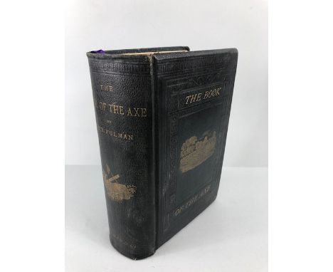
The Book of the Axe by George P. R. Pulman, Local interest, containing a Piscatorial Description of that Stream and Historical Sketches of all the Parishes and Remarkable Places upon its Banks Illustrated with a folding map to frontispiece, linen-backed, as well as fifteen full page plates and numerous woodcuts in text. Fourth edition rewritten and greatly enlarged
![[MAP] ROBERT MORDEN; a map of Devonshire, 37 x 43cm, framed and glazed.](https://cdn.globalauctionplatform.com/4cdb5984-a5bf-4e81-be24-afee00d77448/018f870e-87b6-47d7-a8e1-b0a400abb7ec/468x382.jpg)
![[MAPS] Geographia Antiqua: Being a complete set of maps of Antient Geography, beautifully engraved from Cellarius on thirty-t](https://cdn.globalauctionplatform.com/4cdb5984-a5bf-4e81-be24-afee00d77448/bcf098bc-3d92-4485-aed7-b0a400abcf0c/468x382.jpg)
[MAPS] Geographia Antiqua: Being a complete set of maps of Antient Geography, beautifully engraved from Cellarius on thirty-three copper plates [all present as called for], 1809, New Edition, together with CARY, John, Reduction of his large map of England and Wales, with part of Scotland, 1805, folded, linen backed, and housed in its orignial case (2)
![[TOPOGRAPHY] The New, Complete and Universal History, Description, and Survey, The Cities of London and Weftminster [Westmini](https://cdn.globalauctionplatform.com/4cdb5984-a5bf-4e81-be24-afee00d77448/9726bed0-7473-4793-9e3f-b0a400ab95f4/468x382.jpg)
[TOPOGRAPHY] The New, Complete and Universal History, Description, and Survey, The Cities of London and Weftminster [Westminister], The Borough of Southwark, and the parts adjacent, 1787, printed for Alex Hogg, with maps and numerous illustrations, folio Condition Report:Both boards present but loose, lacking spine. Map at the beginning showing the plan of Cheap Ward present, but loose. The title page has some loss and is dirty. The book is collated as per the main description. Please view the photographs to satisfy yourself of the condition, sold as seen.

![[MAP] ROBERT MORDEN, a map of Staffordshire, 47cm x 42cm, also by the same cartographer, a map of Surrey, 36 x 42cm, each fra](https://cdn.globalauctionplatform.com/4cdb5984-a5bf-4e81-be24-afee00d77448/9724b665-73c5-4ec8-a8fb-b0a400abc168/468x382.jpg)


A SELECTION OF ANTIQUE MAPS OF STAFFORD AND STAFFORDSHIRE ETC, to include Pieter Van Den Keere - Staffordshire circa 1647, approximate size 8cm x 12cm, Rutger Hermannides Stafford town plan circa 1661, Badeslades & Toms county map with details panel published 1742, Thomas Osborne county map circa 1748, Thomas Kitchen county map circa 1786, A & C Black Great Western Railway map, Index Map to the Canals, Rivers and Roads by John Stockdale published 1794, other cartographers and publishers include F.P Becker, John Archer, C Cole & J Roper, Samuel Lewis, R. K Dawson, A. Fullerton Railway map, etc largest approximate size including frame 66cm x 55cm (36)

Liverpool Champions League 2005 Fully Signed Framed Football Shirt: Red shirt with Champions League Winners badging signed by 18 including Gerrard Carragher Benitez Dudek Cisse Baros Kewell Alonsa and more. Signature map and COA available to view with online pictures. Professionally framed with pictures of the team and plaque. Measures 42 x 35 inches and is not for framing. This shirt still has price tag of 1295 pounds on it.

1966 World Cup Workers Pass + Memorabilia: Very interesting lot collected by vendor as he worked as an information officer at Paddington Station for the World Cup Committee. Includes his official pass, luggage label, guides including WC tube map, Programme of matches, 12 World Cup Information Centre unused headed pages, letters to worker on FA headed paper with World Cup logo and more. Some one off items indeed.
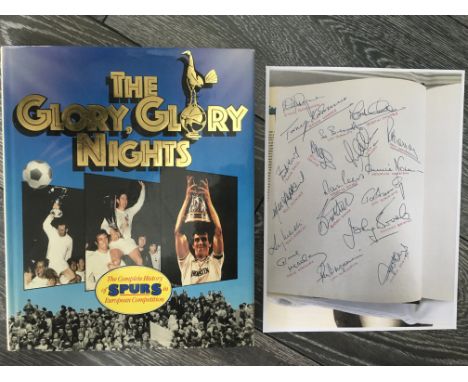
Tottenham Signed Glory Glory Nights Football Book: Inside blank white page is hand signed in blue biro by 18 players and personally collected by a trusted source that knew them. A separate signature map is included. Signatures include Marchi Pratt Jennings Henry Chivers Harmer Perryman Smith Peters and others.


Geschmackvolle Sammlung "Die Fahnen der vereinten Nationen" in Sterlingsilber im Holzkasten. Gesamtgewicht Silber fein ca. 2700 g; ca. 138 Flaggen, Vorderseite geprägt die Nationalflagge, rückseitig die geografische Karte des Staates sowie der Name in der Nationalsprache. Feingehalt 925/1000, punziert und gestempelt, 'JP' und 'P', sowie je mit Seriennummer versehen. Erhaltungen überwiegend vz aus Stgl., teilweise fleckig und Tönungen. Mit Buch!| Tasteful collection "The flags of the united nations" in sterling silver in a wooden box. Total weight of fine silver approx. 2700 g; Approx. 138 flags, the national flag embossed on the front, the geographical map of the state and the name in the national language on the reverse. Fineness 925/1000, punched and stamped 'JP' and 'P', and each provided with a serial number. Conditions mostly XF from BU, partly stained and toned. With book!


Selection (5) of 1930s onwards railway/Underground CARRIAGE NOTICES & MAPS comprising a WW2 Blackout notice, a 1930s Southern Electric map of the suburban area, a 1930s London Underground Season Ticket advertisement by O'Keefe, a 1970s Northern City Line 'Suspension of Service' notice and a c1950s British Railways Southern Region map of suburban services. All are in well-used condition with wear, small losses, short tears etc. [5]

Good quantity (31) of 1922-1934 London General/London Transport POCKET BUS MAPS plus a c1920 folded double-sided WALL POSTER, one side is a map of Roads served by Motor-Buses and the other a List of Motor-Bus Routes with times of first/last buses, fares, intervals and total journey times. Many of the items are well-used and condition ranges from worn to good. [32]

1946 London Underground quad-royal POSTER MAP printed 2/46, designed by H C Beck with a decorative border by 'Shep' (Charles Shepard). Largely in pre-war style, headed 'London's Underground', with the pre-war planned Central & Northern Line extensions to Ongar, West Ruislip, Bushey Heath, Mill Hill (The Hale) and Alexandra Palace shown as "under construction". In reasonably good condition with edge-scuffs and nicks and has been long-term folded with a resulting fragility to the centre horizontal fold. Folded. [1]

1926 London Underground linen-card POCKET MAP from the Stingemore-designed series of 1925-32. This is the April 1926 issue, with green cover, from the smaller-size first sub-series. In very good condition in all respects other than a small mark at the top, l/h corner of the cover and tiny edge-scuffs in a couple of places. [1]

Assortment of 13 GUIDEBOOKS & MAPS, mainly London, from the early 1900s onwards, including Philips' Tube, Bus & Tramway Map, Bacon's Portable Railway, Tube & Tramway Map, Muirhead's Blue Guide, Handbook for South Africans visiting London 1931, LMS maps x 2, Doan's London Street Guide, District Railway Map 5th edition, District Railway Greater London Map 1st edition etc. Condition ranges from heavily used/very worn to very good. [13]
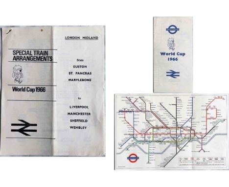
Pair of 1966 football World Cup items, both featuring 'World Cup Willie' on the covers and comprising a special, paper edition of the London Underground POCKET MAP designed by Paul Garbutt and with small maps on the reverse for getting to Wembley and White City stadia, plus a 6-page LEAFLET issued by British Railways, London Midland Region with times of trains from their London terminals to Liverpool, Manchester, Sheffield & Wembley, including special services on match days. The first is in excellent condition, the second is very good with light wear/tiny stains. [2]

Selection (6) of railway CARRIAGE DIAGRAMS etc comprising British Railways 1993 Intercity, modern era GNER ''Principal Rail Routes of Britain' (both laminated board), 1992-93 Network SouthEast network map and 'London Connections', 1993 'Kent Networker' (all thin card) plus c1980s BR(S) '1066 Country' (vinyl). All in good to very good condition. [6]


1933 London Underground H C Beck diagrammatic, card POCKET MAP from the first-year series titled 'Underground Railways of London'. Issued c.September 1933 and has print reference 33-2791. Shows the escalator connection between Bank and Monument stations. An excellent example, crisp and firm. [1]
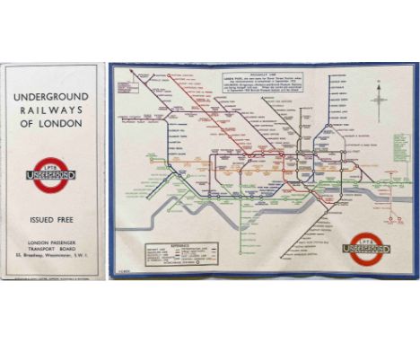
1933 London Underground H C Beck diagrammatic, card POCKET MAP from the first-year series titled 'Underground Railways of London'. This is the edition with no print-code, issued c. August 1933 and has 'LPTB' inside the bullseye logos. Refers to re-naming of Dover St station to Green Park and the merger of Holborn and British Museum stations, all in September that year. Light creasing at one corner, otherwise in very good condition. [1]

1933 MAP of the area under the control of the new LPTB (London Transport) showing the boundaries of the London and Metropolitan Traffic Areas, Metropolitan Police District, roads available to the Board without and with restriction, roads available to Outside Proprietors, Underground and Metropolitan Railways and other railways. Boundaries of other Traffic Areas have been added by hand. Linen-backed inside card covers, opens out to 23" x 28" (59cm x 71cm) and is in very good condition, a little wear to the cover with two names added. [1]

c1902 Central London Railway fold-out POCKET MAP produced to promote its service from Bank to Shepherds Bush. The line is superimposed in red on a street-map background and shows the generating station and depôt at the western end with an inset plan of the subways at Bank at the top right. The reverse has travel and ticket information etc. An excellent copy with only very minor blemishes. [1]
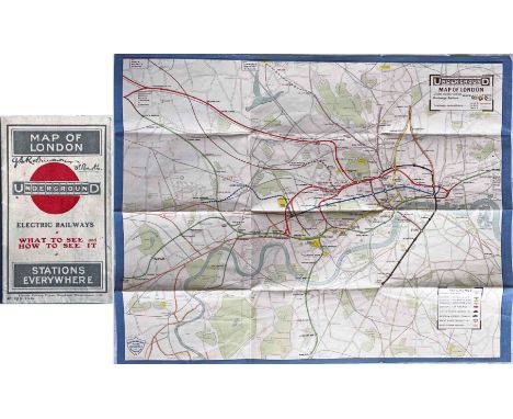
1913 London Underground POCKET MAP 'What to See & How to See it. Stations everywhere' with print-code 487-150M-1.6.13. Opens out to 14 " x 11" (36cm x 28cm). Shows projected extensions to Ealing Broadway, Queens Park and Edgware as well as the LNWR line to Watford in anticipation of the proposed Bakerloo extension. Cover has one of the first printed 'bar & circle' logos, possibly the first such. An excellent example in very good condition indeed with no significant blemishes other than (the first?) owner's name on the cover. [1]
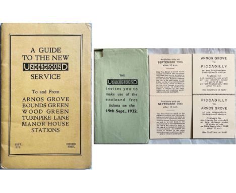
1932 London Underground 'Guide to the New Underground Service' to/from Arnos Grove etc POCKET BOOKLET with card covers dated Sept 1932 and containing a fold-out Underground map of Central London. Most unusually, this comes with the matching pair of complimentary RETURN TICKETS (unused) in their original envelope for use to/from Piccadilly on the opening day of the new service - 19 September 1932. In very good condition, the ticket envelope has a little damage at one corner. [2]
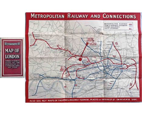
c1932 Metropolitan Railway POCKET MAP, the Met's version of the London Underground map, with its own lines in red and the rest of the system in light blue. This is the green-cover issue with print-code M.1495/100M (no other codes), undated but circa 1932 and shows the Stanmore branch & Piccadilly Line to Cockfosters under construction. Generally in very good, lightly-used condition with light wear. [1]

1937 London Transport quad-royal POSTER MAP of Green Line Coach and Country Bus Routes. These would have been posted on bus shelters, at bus and Underground stations etc. Includes Underground and main-line railways and shows almost the whole LT operating area: Baldock to the north, Horsham to the south, High Wycombe to the west and Tilbury to the east. In excellent condition with only very minor blemishes, the best example of this map that we have seen. Folded. [1]

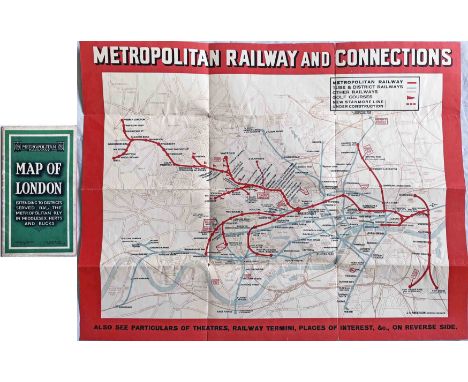
c1924 Metropolitan Railway POCKET MAP, the Met's version of the London Underground map, with its own lines in red and the rest of the system in blue. This is the dark red-cover issue with print-code G.1608/100,000 (no other codes) and is the version with the overprint at Wembley Park for the British Empire Exhibition and Cup Final Stadium. In very good, lightly-used condition. [1]


-
109182 item(s)/page