We found 108737 price guide item(s) matching your search
There are 108737 lots that match your search criteria. Subscribe now to get instant access to the full price guide service.
Click here to subscribe- List
- Grid
-
108737 item(s)/page


Lot 164
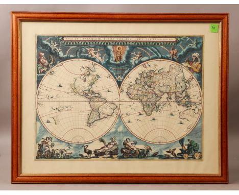
Horsley (John) Britannia Romana, 3 vols. in 1, folio, gilt-cloth, facsimile edition, Frank Graham, Newcastle, 1974, limited edition of 700 numbered copies; Moule (Thomas) The County Map of Old England, folio, cloth, illus., facsimile edition, 1990, with d.w; and Blaeu (Joan) Atlas Major, Vol. 1, Anglia and Vol. 2 Scotia Hibernia, facsimile edition, published by Taschen, in d.s.

Lot 74
Nepos (Cornelius) and Arrol (Robert) (Trans.) Vitae Excellentium Imperatorem: or The Lives of The Excellent Commanders, sml. 8vo, full-calf, fifth edition, Edinburgh, 1775; and Rufi, Q. Curtii (Quintus Curtius Rufus) De Rebus Gestis Alexandri Magni: The Deeds of Alexander The Great, 10 vols. in 1, 12mo, full-calf, illus. with engraved plates, frontispiece and fold-out map, n.d.

Lot 334
Forster (Robert) A History of Corbridge, 8vo, boards, illus., Newcastle, 1881; Mitchell (W. Cranmer) A History of Sunderland, 8vo, boards, illus., Sunderland, 1919; Tomlinson (W.W.) and Charlton (R.J.) A Comprehensive Guide to the County of Northumberland, sml. 4to, boards, illus. with map, revised edition, n.d; and other books and pamphlets relating to Newcastle and Northumberland. (40)

Lot 329
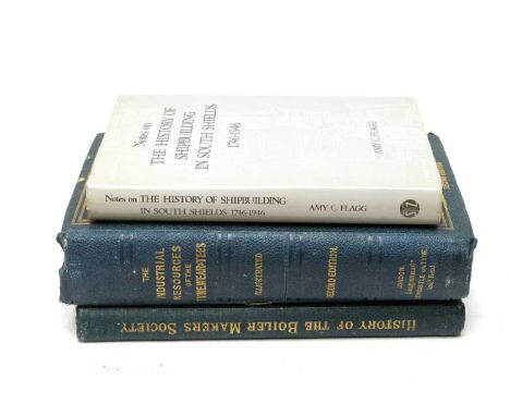
Cummings (C.C.) A Historical Survey of the Boiler Makers' and Iron and Steel Shipbuilders' Society, 1834-1904, 4to, gilt-cloth, illus., Newcastle, 1905, presentation copy, signed by the Chairman and other members of the Society; Armstrong (Sir W.G.), Taylor (John), and Bell (I. Lowthian) (Editors) The Industrial Resources of the Tyne, Wear and Tees, 4to, illus. with double-page frontispiece, fold-out map, other maps and plates, Newcastle, 1864; and Flagg (Amy C.) Notes on the History of Shipbuilding in South Shields, 1746-1946, 8vo, cloth, first edition, 1979, with d.w. (3)

Lot 191
The Industrial Resources of the Tyne, Wear and Tees, including reports on the local manufacturers read before the British Association in 1863, 8vo, original printed boards, illus. with map, plans and wood engravings, second edition, Newcastle 1864; Mandl (G.T.) Three Hundred Years In Paper, 4to, cloth, illus., 1985; A Scientific Survey of North-Eastern England, 4to, original printed paper covs., published for the British Association for the Advancement of Science, Newcastle, 1949; and other books and publications relating to Industry and Commerce in the North of England. (9)
Lot 220
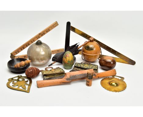
A BOX OF 19TH AND 20TH CENTURY TREEN, METALWARES AND GLASS, including a wooden shaped egg with papered world map decoration and fitted with a ceramic inkwell, height 7cm, s.d., a Mauchline ware string ball printed with St David's cathedral, an advertising Mauchline ware bodkin case printed with Ballochmyle Creamery, Mauchline and 'SEAFOAM FOR BEST CAKES', height 5.2cm, a coquilla nut carved as an egg, an olive wood Jerusalem egg, two horse brasses, a silvered bauble with trailed decoration, height 10cm, two chuckmuck flint purses, possibly Tibetan, widths 11.5cm and 9.8cm, a miniature wooden and fabric parasol, height 21cm, a J. Rabone & Sons no.1499 folding brass 24 inch ruler and a vegetable ivory needle case with acorn shaped screw ends, length 7cm, etc ( 17) (Condition report: in mixed condition overall, most items have some faults including the map inkwell has a chipped section below the word 'PACIFIC', two splits and ink stained interior, Mauchline ware has surface scuffs, coquilla nut has a split in the rim of the lower half and smaller chuckmuck has worn leather and fabric to the flap)

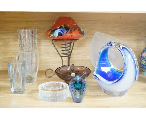
Lot 290
STAFFORDSHIRE, CHRISTOPHER SAXTON & PHILIP LEA, a 17th Century map with plans of Stafford and Lichfield to the right hand side, hand coloured outlines, in card mount, framed and glazed, map 41.2cm x 52cm (Condition report: the centre fold is overlapping down the majority of the map, some areas of discolouration)


Lot 292
STAFFORDSHIRE, PLOT (ROBERT), '....This Map of Staffordshire newly delineated after a new manner with all imaginable Submission is humbly dedicated by RP LLD', engraved by Joseph Browne 1682, hand coloured, borders decorated with heraldic shields, card mount, framed and glazed, map 63.5cm x 54cm (Condition report: the map has slipped in the mount, there is a large stain in the centre line in the bottom half of the map which could be Sellotape stains from the reverse side, there are other stains below the head of the figure in the bottom right hand corner and below cartouche in the top right hand corner)

Lot 293
AFTER HENRICUS HONDIUS 'HAEMISPHAERI GRAPHICUM COELI TI ET UM SCENO AUSTRALE STELLA TERRAE', a hand coloured celestial map, bears name and dated 1661, in a card mount, framed and glazed, map 43.5cm x 50.5cm (Condition report: areas of creasing, foxing and staining, slight tear to the bottom edge just off centre)


Lot 381
Henry Cliffe,Abstract,signed and dated '64, artist's proof screen print,57x78cm,and other reproductive prints.Condition report:The Henry Cliffe is a bit grubby and mark around the outside of the picuture there are what looks like grubby thumb marks to the bottom edges. There is some dirst and insect under the glaze. The other prints are not by Henry Cliffe are all framed and galzed, mostly of churches, buildings, one map, a water colour of chickens and others.


Lot 1222
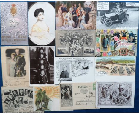
Postcards, Military, a good collection of approx. 48 Boer War cards with early coloured vignettes published by Tuck in the Empire series inc. Gen Clery, Gen Redvers Buller, Gen Lyttleton, maxim gun etc. Also illustrated Manchester Regt., various other Generals, Boer Personalities, Transvaal coin card, firing practice, Gruss Aus Johannesburg, chromo map of Transvaal with inset Kruger and Joubert, chromo of Kruger, many cards featuring Boers etc. Nice mix (mixed condition)


Lot 139
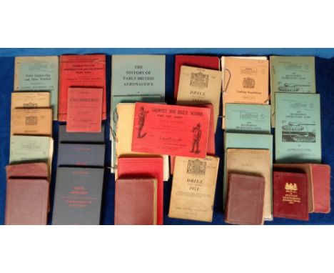
Military Instruction Manuals, 30+ books and booklets most dating from 1900- 1950 to include Royal Tournament Field Gun Display Competition Rules, 1901 Manual of Military Engineering, 1912 Yeomanry and Mounted Rifle Training, 1914 Infantry Training, 1912 Musketry Training, 1905 Gale & Polden Hints on Stable Management, 1910 Manual of Military Cooking, 1912 Manual of Map Reading and Field Sketching, Gale & Polden Trumpet & Bugle Sounds etc. (fair/gd) (30+)
Lot 1583
Postcards, Royalty, a mix of 14 early cards, mainly European Royalty, inc. Gruss Aus style President McKinley and Queen of Spain, also inset map of Cuba 1898, RP of Czar's children, miniature Cadillac purchased by Queen Alexandra for Crown Prince Olav, Gruss Aus Berlin 1897, Gruss Aus Prussian F315Royal Family, portrait of Princess Helene of Greece, Kaiser military parade 1897, stamp card (Austria), rotating wheel for Kaiser's family, embossed portraits of Alfonso XIII and Victoria Eugenia of Battenburg 1905 etc (mainly gd)


Lot 953
John Speed/Map of Gloucestershire/published by Roger Rea 1665/colour engraved map, 41.5cm x 53.5cm CONDITION REPORT: Condition information is not usually provided in the description of the lot but is available upon request; the absence of a condition report does not imply that a lot is without imperfection

Lot 954
A map of Cornwall from the Best Authorities, engraved by John Cary, published by John Stockdale, Piccadilly 26th March 1805, 41cm x 53cm CONDITION REPORT: Condition information is not usually provided in the description of the lot but is available upon request; the absence of a condition report does not imply that a lot is without imperfection


Lot 352
A frosted art glass bowl on stand with ‘face’ pattern to base together with an Iitalla map ash tray designed by Tapio Wirkkala, a bohemian iron and spatter pattern glass shade oil lamp, Tom Philabaum art glass perfume bottle together with other pieces of etched Scandinavian glass and art glass


Lot 139
1974 BMW 2002 Baur Convertible Transmission: manualMileage:98000The BMW 2002 series is important in the history of BMW for several reasons; not least of which being that it brought the company out of near bankruptcy in the 1960s and put BMW on the map in the United States. It was the ancestral grandfather to the BMW 3 Series and was produced from 1968 to 1976. German BMW importer Max Hoffman is credited with the car's creation. He had suggested to BMW's engineering director that a 2.0 litre engine should be installed into the small two-door 1602 to improve performance and emissions. The resulting 2002 (named after the new motor's displacement) was popular in its first year on sale. This BMW 2002 is one of only 354 examples manufactured in right hand drive format. Conversions on these outstanding vehicles were carried out by coachbuilder Karosserie Baur in Stuttgart. Baur retained a 'T' bar in the roof design helping to dramatically reduce any scuttle shake.This 2002 convertible by Baur is presented in an individual bronze metallic with the original houndstooth trim. With just three previous owners, the last for 33 years, it has been sympathetically restored over its life including new wings - a rolling restoration some may say. A real car for the enthusiast offered with a new MoT test certificate and long-term low ownership.Guide Price £12,000 - £16,000

Lot 279
1993 Mazda MX5 Transmission: manualMileage:85000There is little doubt that the MX5 re-invigorated the sportscar market on a global scale. Spirited performance combined with good looks, reliability and price put this incredible package firmly on the map. This Mazda MX5 is a genuine UK supplied car and is the desirable 1.8 iS model which benefitted from the more powerful 1.8 litre 130bhp engine as well as a driver's airbag, ABS, bracing bars to stiffen the body, electric door mirrors and a factory fitted immobiliser. Originally registered in Japan and imported to the UK in 2002, this 1.8 litre Mk. I MX5 is presented in red with black trim. Supplied with limited slip diff, electric windows, and air conditioning, much has been spent on this little gem. Recent works include a major service which encompassed a new water pump, thermostat, and belts. Also boasting new shocks and springs from the original specification coupled to new battery, wheels, and tyres. Recently, the seats have been re-upholstered in Italian leather with classic headrests and the bodywork has recently been rustproofed and attended to by MX5 restorers. Described by the vendor as in near perfect condition, he has gone to great lengths to ensure that every detail has been attended to. An excellent driving car with an MOT test certificate valid until March 2023, this is a fabulous genuine example. Guide Price £6,000 - £8,000


Lot 592
Three small 17th/18th century map engravings - Hamp Shire by Herman Moll, 22 x 26 cm, Asie par (Eustache) Hérisson, 25 x 21 cm (unframed) and 'Indiae Orientalis...', by Philip Cluver, 27 x 22 cm to/w seven 19th century steel engraved maps and four topographical engravings - two of Winchester and two Oriental subjects (14)
Lot 245
EDWIN THOMAS DOLBY watercolour - view of Tenby harbour with castle, signed and dated 1856 (together with an 1832 ordnance survey map of town)Dimensions: 16.5 x 23.5cmsProvenance:private collection Cardiff, consigned via our Cardiff officeCondition Report:slight blemish(es), framed and glazed

Lot 429
JOHN SPEED antiquarian map of Wales, titled 'Wales' and flanked by twelve oval vignettes of the principal towns and with four inset views of the cities of St Davids, Llandaff, St Asaph and Bangor, Thomas Bassett & Richard Chiswell 1676 Dimensions: 38 x 50cmsProvenance:private collection Cardiff, consigned via our Cardiff officeCondition Report:old Baxter-type frame, glazed, uncoloured, without notable tears, holes or creases


Lot 288
Six large decorative pictures and prints:Richard Beer, 'Hotel de la Gare', 41 of 70 (38 x 46cm);Richard Beer, 'Boulangerie', 11 of 70 (54 x 40cm);Richard Beer, 'Trying Out Watercolour - Ribola July 5' (56 x 37cm);Continental landscape (35 x 44cm);acrylic on card still life (57 x 76cm);a laminated Ordnance Survey map centred on Weybridge (60 cm square);
-
108737 item(s)/page