We found 109182 price guide item(s) matching your search
There are 109182 lots that match your search criteria. Subscribe now to get instant access to the full price guide service.
Click here to subscribe- List
- Grid
-
109182 item(s)/page


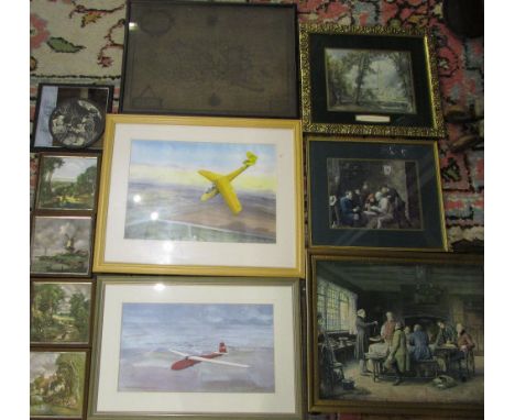
Lot 316
Three plans of London Docks to include tow linen examples, "Plan of East and West India Docks 1886", "Port of London, Sharing Sufferance Wharves and Up-Town Warehouses" and a map of Thames Wharves compiled by Temple Thompson and Clark, Steam Ship Owners and Brokers Colliery Agent London 1912" (3). CONDITION REPORT "Plan of East and West India Docks 1886" - 37 x 53cm (af) "Port of London, Sharing Sufferance Wharves and Up-Town Warehouses" - 38 x 67cm Thames Wharves - 68 x 103cm


Lot 584
Assorted Railwayana including a limited issue commemorative plaque for Warship Class 2200 no 1711/3000 to/w a Piccadily Line underground carriage line map, a Golden Arrow to Paris Pullman coach poster (framed ex carriage); an oak framed GWR route map; a BR SR line double sided map, a London-Southampton-Bournemouth line electrification advertising board

Lot 22
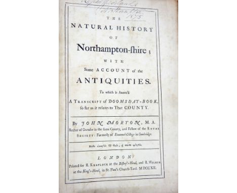
Whellan, William & Co "History, Gazetteer and Directory of Northamptonshire; comprising a general survey of the county and the history of the diocese of Peterborough...", Whittaker & Co 1849, map missing, inscription on ffep named then Wellingborough 1849, hinges cracked, backstrip separating, bumped and worn Baker, Ann Elizabeth "Glossary of Northamptonshire, words and phrases...", John Russell Smith 1854, two volumes, purple blind stamped cloth with gilt titles, backstrips faded "Northamptonshire notes and queries 1888-89, 1892-93 and 1894-95" Morton, John "The Natural History of Northamptonshire...", London, R Knaplock 1712, two volumes, plates, maps missing, various loose maps and geographical plans, fossil plates included, marbled boards, half-leather, volume one backstrip separated, boards separated, condition poor and other related volumes (15)

Lot 41
Stanley, Henry M "In Darkest Africa or the Quest and Retreat of Emin, Governor of Equatoria", two volumes, Sampson Lowe, Marston, Searle & Rivington 1890, numerous illustrations, folding map in both volumes, end papers with map of coastal Africa, name and inscription dated 1932 inside front cover volume two, red pictorial cloth, gilt titles, backstrips a little worn, binding tight

Lot 44
Constable's Miscellany of Original and Selected Publications in the Various Departments of Literature, Science and the Arts Volume XL "The Ottoman Empire volume 1", Edinburgh 1829, "The Ottoman Empire volume 2" Edinburgh 1829 and "The Conquest of Peru" 1830, bookplate inside front cover of each book, small 8vo, folding map in volume 2 of the Ottoman empire, engraved vignette of Constantinople, title page volume 1, contemporary marbled boards and half-leather but worn and rubbed
Lot 53
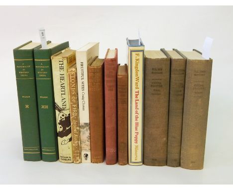
"China Proper, Volume I, Physical Geography, History and Peoples July 1944" Naval Intelligence Division, B.R.530 (restricted) geographical handbook series for official use only, various illustrations, photographic and other, folding map in pocket on back board, "Volume II - Modern History and Administration June 1945", "Volume III - Economic Geography, Ports and Communications July 1945", green cloth, gilt titles Wilson, Ernest Henry "A Naturalist in Western China with Vasculum, Camera and Gun", Methuen & Co 1913, in two volumes, green cloth, gilt titles, numerous photographic illustrations Cox, E H M "Plant - Hunting in China - a history of botanical exploration in China and the Tibetan Marches", Collins 1945, photographic illustrations, colour frontis, red cloth worn Gutzlaff, Rev. Charles "The Life of Taou-Kwang, Late Emperor of China: with memoirs of the court of Peking...", Smith, Elder & Co 1852 and various other related volumes (12)


Lot 450
JAMES BOND 1:8 SCALE ASTON MARTIN; A large and heavy quality 1:8 scale Eaglemoss diecast precision model of James Bond's Aston Martin DB5. Highly detailed, the original spec for the model includes; working rear and front lights, working horn, ejector seat, accelerator sound effects, brake lights, light up map to interior, machine guns in lights, movable bullet proof rear screen, key ignition, rubber tyres etc. This particular model is well made. Just one or two of the features are not working (accelerator, no guns to rear lights), but on the whole this is in fantastic condition. Comes with a custom made glass and wooden display case and plinth, and original magazines 56cm long, approx 8.5kg. CAN BE POSTED WORLDWIDE CONTACT US FOR A QUOTE, OR VIEW www.eastbristol.co.uk.


Lot 283
"THE PICTURE OF BIRMINGHAM" (an historical and descriptive account), printed for James Drake 1825, with fold-out map and illustrations, together with "DAME WIGGINS OF LEE" by John Ruskin, 1926, Garton, "GLOWING EMBERS FROM A SOMERSET HEARTH", 1937, a nd "THE INTELLIGENT WOMAN'S GUIDE TO SOCIALISM AND CAPITALISM" by Bernard Shaw, 1928 (4)


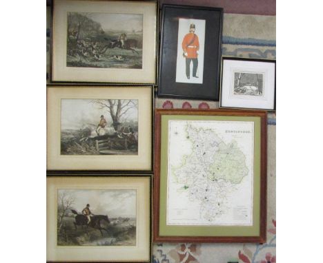
Lot 224
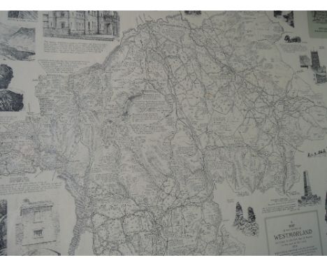
INTERESTING HARDBOUND SCRAPBOOK OF SCOTTISH HISTORY probably compiled mid 20th century, documenting notable characters including Sir William Wallace, Robert the Bruce, 1st Duke of Gordon, Viscount Dundee and Lieutenant General Hugh Mackay of Scowry, episodes and battles through the ages Bell O' the Brae, Stirling Bridge, Bannockburn, Sherriffmuir, Largs, Flodden, Glencoe Massacre, Drumclog, Bothwell Bridge and Killiekrankie, partial map of 'North East Part of Perthshire' published 1827, period engravings and later images, newspaper and magazine clippings, Clans and weaponry, viewing required
Lot 225
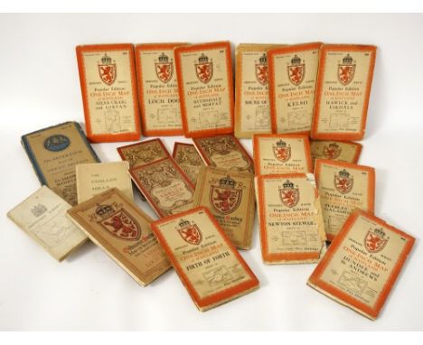
SELECTION OF ORDNANCE SURVEY MAPS OF SCOTLAND including thirty one from the National Grid Popular Edition One Inch Map of Scotland series in cloth, two cloth editions of the Tourist Map of The Trossach and Loch Lomond, and Lower Strath Spey, two quarter inch maps of The Eastern Highlands, and Glasgow and the Middle West, two Popular Edition maps of Thurso and Reay, and Lairg and Loch Shin, a cloth edition of Berwick, four Coloured Editions of Loch Eil and district, Cluanie and district, Tongue and District and Loch Carron and district, and a cloth edition of The Cuillin Hills Skye from the Scottish Mountaineering Club


Lot 347
A BING O Gauge Flying Scotsman C/W Train Set comprising a LNER Green 4-6-0 Flying Fox and no 4472 3 axle Tender ( minor age crazing to Paint work otherwise Excellent), 2 Bing LMS Maroon Coaches with opening Lids revealing Tables and Chairs (age crazing to Paint work otherwise Excellent) and an oval of Bing wooden sleepered C/W Track. The Set is housed in an Excellent Blue Box with a Map of the 'Flying Scotsman route on the inside of the Lid. A rare Boxed find in this condition.
-
109182 item(s)/page