India – Punjab – Forster’s Travels in India A fine copy of Travels in the Northern Part of India^ Kashmir^ Afghanistan^ and Persia and into the Caspian Sea in the yeas 1782^ 1783 & 1784 by George Forster^ 1813^ with pull out map of Hindoostan^ and several plates one of which is folding. Forster describes crossing the Rawee [sic] to the city of Lahor [sic] and refers to the local population as ‘Sicques’ [Sikhs]. Front cover loose^ bound in contemporary half calf with marbled boards and new gilt label.
We found 109198 price guide item(s) matching your search
There are 109198 lots that match your search criteria. Subscribe now to get instant access to the full price guide service.
Click here to subscribe- List
- Grid
-
109198 item(s)/page
India – The Punjab^ Northwest Frontier Province And Kashmir By Sir James Douie. Cambridge University Press^ Cambridge^ 1916. First. 8vo^ 373 pp^ 150 illustrations^ Geography^ people^ history^ natural history of Northern India. Profuse ill. Pull-out map^ Patiala Sate^ Punjab Princes^ Amritsar^ Lahore^ Punjab Coinage etc. from photos. VG+ in orig map stamped front cover.
India Punjab – Important Sikh War map Theatre of war map. A rare Wyld’s ‘Theatre of War in the Punjaub Map’^ inscribed ‘To The Right Hon. Sir Henry Hardinge Lieut Gen^ Governor General of India – This Map of the Routes through the Punjaub and the Adjoining States’. London^ 2nd March 1846. Approx 23” x 202 backed in buckram^ folds into a hard back cover book. Original brown binding^ with old paper label to front. The James Wyld map of the Punjaub in the original hard cover is most scarce and desirable as it was published during the First Anglo Sikh War. Hand coloured in outline.
MAUCHLINE WARE BLACK LACQUER CYLINDRICAL BOBBIN BOX, the top with `Anchor Calendar 1878`, the whole spinning on its integral base for game of chance, 4 1/4" (10.8cm) diameter and a BLACK LACQUER ROCKER BLOTTER advertising `The Western Telegraph system and connections with South America` with map, 5 1/4" (13.3cm) wide (2)
MISCELLANEOUS COLLECTION OF PRE AND POST WAR EPHEMERA mainly RELATING TO MANCHESTER AND SALFORD, inlcudes circa 1920s large scale folded linen map Manchester and Salford showing tram, bus and rail routes, Palace Theatre programme 1949, pack of six Guinness Postcards, promotional booklet `Salford the Gateway to South East Lancashire` 1924 to coincide with British Empire Exhibition, two Coronation programmes 1937 and 1953 and a SMALL COLLECTION OF GB and WORLD POSTAGE STAMPS, used and mint examples, predominantly 20th Century in the Gay Venture and Trusty albums
A collection of approximately thirty printed handkerchiefs, subjects comprise the Royal family Princess Elizabeth, Coronation of Edward VIII, Queen Victoria Jubilee, Boer War, Coronation of George VI, Ypres, Winston Churchill, etc., also a scrapbook with numerous little flags to commemorate Flag Day, Regiments, Worcester City Council Nursing Association, early Haig Fund Poppies, also a Berrow's Coronation Souvenir and a map
A collection of five maps to include a mid 16th century Michael Drayton hand tinted map of the county of Denbighshyre, showing the various mythical figures, 25x33cm, framed and glazed, a late 17th century hand tinted map of the county of Staffordshire by William Kip, 27x37cm, framed and glazed, 18th century hand tinted map of the road from York to Lancaster, 18x11cm, framed and glazed, 18th century hand tinted map of the road to London to Oakham, 18x12cm, framed and a 19th century coloured map of the county of Cheshire (5)
Collection of world war one military magazines relating to aircraft and other related books. together with misc. world war one ephemeral incl. postcards, Kreta arm band, miniature photo album with black and white photos of biplanes, officers on horseback together with Militarpaak German book to Sgt. Heinrich and a German war map and other related items.
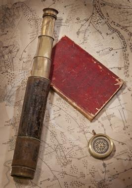
A COLLECTION OF ARTEFACTS PERTAINING TO WILLIAM COLLINGWOOD`S INDIAN SURVEYING EXPEDITION, 1846, comprising a passage journal kept aboard the Oriental from London to Bombay between 6th January and 30th May 1846, written over sixty-nine pages in a neat and clear hand with occasional coloured ink sketches, varied content including weather observations, poetry, and day-to-day commentary - March 31st 1846 Tuesday: A large shoal of porpoises playing about the bows the mate went out on the dolphin striker to harpoon one but was unsuccessful.. bound in red morocco with inscribed cover -- 7¼ x 4¾in. (18.5 x 12cm.); together with a presentation leather-cased 1½in. three-draw leather-covered surveying telescope and compass compendium signed and inscribed A. Ross, London / From Comr. Selby, Surveyor in Mesopotamia to Lieut. W. Collingwood, Asst. Surveyor, in kind remembrance of Services together in Babylonia & Irak Arabia, contained in leather carry case with lid enclosing a lacquered-brass compass, closed length -- 11½in. (29cm.); three 7 x 9in. (18 x 23cm.) watercolour and ink ship profiles by Collingwood of the Tigris; Coromandel and Georgiana each inscribed, signed and dated between 1856-8 and attached to ?album leaves; a printed service record for Collingwood (`H.M. late I.N.); and a map printed by J & C Walker, London of a Trigonmetrical Survey of a part of Mesopotamia by Selby and Collingwood , (7), Please see back cover image, Provenance: The family and thence by decent, Commander W.B. Selby, late Royal Indian Navy, began his distinguished surveying career in 1837 when, as a midshipman, he embarked on the expedition first to lay navigation buoys in the mouths of the Indus River and thence to chart some coastal areas in the `Horn of Africa`. By 1846 he was back working off the mouths of the Indus, having made his reputation in Mesopotamia (in 1840-41), and thereafter achieved considerable acclaim for his numerous other surveys, including those during the military expedition to Persia in 1856, before returning home (to England) at the end of 1862. He was succeeded as Surveyor of Mesopotamia by his protege, Lieutenant William Collingwood (a distant cousin of the Admiral), who had already done much valuable work in the region, including the large-scale, though surreptitious, mapping of Baghdad in 1855 and described by him as follows:-, "The survey of the city of Baghdad was completed entirely by myself and under very unpleasant restrictions....... The Turkish Government were not to know anything about it....... and I was left to survey the town as best I could, and under such difficulties that at times I had to note bearings and paces all over my white shirt, where best I could get the pencil at the time.....", During this same expedition, Collingwood also surveyed the Shatt-ul-Arab, the city of Bussorah (also by stealth) and much of the country between the Tigris and Euphrates Rivers, and was undoubtedly one of the most gifted and productive R.I.N. surveyors of his day.
Model Railway News magazines, Modern Catalogues and Railwayana: consisting of Model Railway new 1920s and 1930s (55), undated GWR map, BR map, Train register for Caton signal box 1963/64, GWR Debenture stock Certificate stamped 1947, Modern Photographs, Postcards and modern 00 gauge product catalogues, F-G (Qty)
18th century tinted engraved map - `The River Avon From the Severn to the Citty of Bristoll` surveyed by G. Collins, dedicatory panel lower left `To the Right Worshipfull Robert Yate Esqr Mayor of Bristoll and Master of the Merchants Hall in that City This Mapp is Dedicated and Presented by Capt Greenvile Collins`, in a late 20th century frame, 41cm x 92.5cm
An 18c plan of the cities of London, Westminster and Borough of Suffolk with the new additional buildings and described as `a new map of London most humbly inscribed to the Right Worshipful Sir Peter Deline KT and Alderman of London 1720`, with references to London, Westminster and Suffolk, with scale, framed and glazed, 19" x 23"
-
109198 item(s)/page