
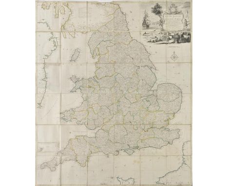
Warwickshire. The History of the Town and School of Rugby, by Nicholas Harris Nicolas, 1826, six engraved plates, folding pedigree, original part wrappers bound in, top edge gilt remainder untrimmed, late 19th/early 20th century calf, title label deficient, joints rubbed, 8vo, together with Warwick Castle and its Earls from Saxon Times to the Present Day, by the Countess of Warwick, 2 volumes, 1903, black & white illustrations, folding pedigree, top edges gilt, remainder untrimmed, original green cloth gilt, torn at foot of spine to volume 1 , 8vo, with The Visitors' New Guide to the Spa of Leamington Priors, and its Vicinity..., by W.T. Moncrieff, 3rd edition, Leamington Priors, 1824, lithograph frontispiece, folding plan and map, twelve plates, occasional spotting, edges untrimmed, original printed boards, joints cracked, marked and some wear, 8vo, and The Governing Charter of the Borough of Warwick, 5 William and Mary, 18 March, 1694..., by Joseph Parkes, 1827, occasional spotting and dust-soiling, later endpapers, contemporary cloth-backed boards, 8vo, and Warwickshire: being a concise Topographical Description of the Different Towns and Villages in the County of Warwick, by William Dugdale, Coventry, [1830], folding map and 6 only (of 7) engraved plates, 19th century half-calf gilt, 8vo, plus other Warwickshire related, 19th & 20th century publications (40)
We found 109198 price guide item(s) matching your search
There are 109198 lots that match your search criteria. Subscribe now to get instant access to the full price guide service.
Click here to subscribe- List
- Grid
-
109198 item(s)/page
Willis (Nathanial Parker & Coyne, Joseph Stirling). The Scenery and Antiquities of Ireland, Illustrated from Drawings by W.H. Bartlett, 2 volumes, George Virtue, [1841], engraved portrait frontispiece, additional engraved titles, 118 engraved views, and an engraved map of Ireland, complete as list, plates generally toned, with some light spotting and occasional marginal water-staining, all edges gilt, original green embossed morocco, rubbed, rebacked preserving original gilt decorated spines (faded), 4to (2)
![Adriatic and Mediterranean. Magini (Giovanni Antonio), Marca Anconae olim Picenum, [1598 or later], uncoloured engraved map o](https://cdn.globalauctionplatform.com/6f06c57b-9702-4210-a2e3-a7400109952d/17538c95-8f28-4e4f-bbb3-5fec3933a820/468x382.jpg)
Adriatic and Mediterranean. Magini (Giovanni Antonio), Marca Anconae olim Picenum, [1598 or later], uncoloured engraved map of the Italian Marches around Ancona, 125 x 175 mm, Italian text below and on verso of map, together with Gastaldi (Giacomo), March de Ancona Nova, published Venice, circa 1548, uncoloured engraved map, 130 x 175 mm, Italian text on verso, with another copy similar with sparse hand colouring, with Bertius (Pieter), Marcha Anconae olim Picenum, circa 1616, hand coloured engraved map, 85 x 125 mm, Dutch text on verso, plus Ortelius (Abraham), Marca Anconitana, circa 1600, hand coloured engraved map, 75 x 110 mm, French text on verso (5)


Australia. Bellin (Jacques Nicolas), Carte R‚duite des Terres Australes, 1753, uncoloured engraved map, old folds, 210 x 285 mm Originally published in Prevost's 'Histoire Generale des Voyages'. A geographically naive 'pre Cook' map showing the Eastern coastline of Australia running unbroken from Tasmania up to New Guinea. (1)
![Australia. Coronelli (Vincenzo), Het Niew Hollandt. Nuova Guinea, published Venice, [1697], uncoloured engraved globe gore of](https://cdn.globalauctionplatform.com/6f06c57b-9702-4210-a2e3-a7400109952d/ff9dbfb5-1574-425c-8fe6-3581b40c8ecc/468x382.jpg)
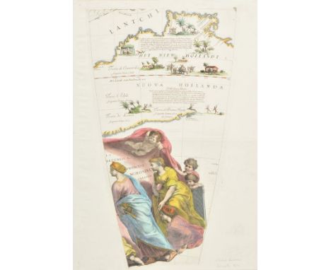
Australia. Coronelli (Vincenzo), Het Niew Hollandt. Nuova Guinea, published Venice, [1697], uncoloured engraved globe gore of the Dutch discoveries in the Spice Islands, Papua New Guinea and Australia from the northwest Cape to the Gulf of Carpentaria around Weipa, one small hole to lower margin, map size 230 x 290 mm, Italian text below and on verso of map Uncommon. (1)
Australia. Coronelli ( Vicenzo), Het Niew Hollandt, circa 1690, hand coloured engraved globe gore, 480 x 290 mm Uncommon. Coronelli's gore includes an important map of Australia, one of the earliest obtainable maps to focus on the north western coast of Australia in some detail. The gore is famous for the fanciful depiction of inland Australia, complete with palm trees, reindeer and elephants. (1)
Azores. Ortelius (Abraham), A‡ores Insulae, [1584], engraved map with contemporary hand colouring, large strapwork cartouche, some water staining causing some 'bleeding' to watercolour, strengthened on verso with archival tissue, 330 x 470 mm, Latin text on verso Marcel van den Broecke, Ortelius Atlas Maps, no.24. (1)


BRADSHAW (George, pub.). G.Bradshaw's Map of Canals Situated in the Counties of Lancaster, York, Derby & Chester; Shewing the Heights of their Pools from a level of 6ft. 10in. under the Old Dock Sill at Liverpool, from levels taken by William Johnson and Son, Manchester, circa 1830, engraved map with contemporary outline colouring, sectionalised and laid on linen, calligraphic title, table of reference & explanation, 875 x 1250 mm, edged in green silk, marbled endpapers with manuscript title to upper cover, contained in a contemporary gilt calf book box, contrasting morocco label to spine, ink annotation to upper board, marbled edges, rubbed and frayed at extremities (1)

British Isles. Waldseemuller (Martin & Fries Lorenz), Untitled map of the British Isles (Europae Regionum Traditio Recens on verso), published Lyons, [1535], hand coloured Ptolemaic woodblock map of the British Isles on a trapezoidal projection, Scotland orientated to the east, central fold professionally repaired on verso, 300 x 440 mm, Latin text on verso A re-issue of the Lorenz Fries edition of 1522. This state edited by Melchior and Gaspar Treschel. R.W.Shirley. Early Printed Maps of the British Isles 1477 - 1650, no.24. (1)
![British Isles. Waldseemuller (Martin), Tabula Moderna Hiber, published Strasbourg, [1525], uncoloured woodblock map, title in](https://cdn.globalauctionplatform.com/6f06c57b-9702-4210-a2e3-a7400109952d/2e6317d1-1d33-4f1b-f7e1-b50f5f98ec08/468x382.jpg)
British Isles. Waldseemuller (Martin), Tabula Moderna Hiber, published Strasbourg, [1525], uncoloured woodblock map, title in a decorative scroll above map, some worming, professionally restored and largely confined to lower margin, slight thinning to paper at top of central fold, slight browning to central fold, 320 x 420 mm, Latin text (with title Tabula Nova) set into decorative columns to verso R.W.Shirley, Early Printed Maps of the British Isles 1477 - 1650, no 18. (1)
![British Isles. Ortelius (Abraham), Britannicarum Insularum Typus, [1603], hand coloured engraved map, originally published in](https://cdn.globalauctionplatform.com/6f06c57b-9702-4210-a2e3-a7400109952d/087b4b7b-e2d7-48ef-9b80-7bc812224d00/468x382.jpg)
![British Isles. Blaeu (Willem Janszoon), Magnae Britanniae et Hiberniae Tabula, published Amsterdam, [1631 or later], engrave](https://cdn.globalauctionplatform.com/6f06c57b-9702-4210-a2e3-a7400109952d/51d7bf38-75d4-414e-8c5d-62c3e9ef4582/468x382.jpg)
British Isles. Blaeu (Willem Janszoon), Magnae Britanniae et Hiberniae Tabula, published Amsterdam, [1631 or later], engraved map with contemporary outline colouring, inset map of the Orkney Islands, strapwork cartouche and mileage scale, some spotting largely confined to margins, 390 x 505 mm, Latin text on verso R.W.Shirley. Early Printed Maps of the British Isles 1477 - 1650, no.423. (1)

British Isles. Munster (Sebastian), Engellandt mit dem anstossenden Reich Schottlandt so vor Zeiten Albion und Britannia haben geheissen, published Basle, [1588 or later], hand coloured woodcut map, orientated to the west, published in the 'Cosmographia' by Sebastian Petri, 320 x 360 mm, German text on verso R.W.Shirley. Early Printed Maps of the British Isles, 1477 - 1650, no. 148. (1)

British Isles. Blaeu (Johannes), Britannia prout divisa suit temporibis Anglo-Saxonum praesertim durante illorum Heptarchia, published Amsterdam, [1645 or later], engraved map with contemporary hand colouring, vertical margins decorated with fourteen scenes of Saxon figures and events, slight staining to margins, 415 x 535 mm, Latin text on verso R.W.Shirley. Early Printed Maps of the British Isles 1477 - 1650, no. 549. (1)
![British Isles. Ortelius (Abraham), Angliae, Scotiae et Hiberniae sive Britannicar Insularum descriptio, [1592], hand coloured](https://cdn.globalauctionplatform.com/6f06c57b-9702-4210-a2e3-a7400109952d/8be93e80-a3ae-4975-c834-488f30d4e52e/468x382.jpg)
British Isles. Ortelius (Abraham), Angliae, Scotiae et Hiberniae sive Britannicar Insularum descriptio, [1592], hand coloured engraved map, orientated to the west, large strapwork cartouche, 350 x 500 mm, Latin text on verso Marcel van den Broecke. Ortelius Atlas Maps, no.16. R.W.Shirley. Early Printed Maps of the British Isles, 1477 - 1650, no. 86. (1)

British Isles. Quad (Matthias), Angliae regni florentissimi nova descriptio auctore Humeredo Lhuyd Denbygiense, published Cologne, [1592 or later], hand coloured engraved map, large strapwork cartouche, repaired marginal closed tear not affecting image, 185 x 270 mm, German text on verso, together with Cloppenburgh (H. Jan Evertsz), Anglis Scotia et Hibernia, published Amsterdam, [1630], hand coloured engraved map, old folds, 190 x 260 mm, with Cluver (Philip), Veteris et Novae Britanniae Descriptio, published Amsterdam circa 1696, hand coloured engraved map, inset map of the Orkney Islands, 215 x 265 mm, plus Mercator (Gerard & Hondius Henricus),Anglia, Scotia et Hibernia [and] Anglia, circa 1621, two hand coloured engraved maps, each approximately 135 x 180 mm, Latin text on verso, and Bertius (Pieter),Anglia Scotia et Hibernia, circa 1618, hand coloured engraved map, 95 x 135 mm, French text on verso, with another two maps similar (8)
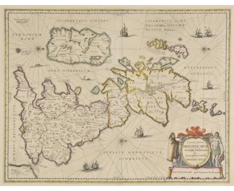
British Isles. Jansson (Jan), Insularum Britannicarum Acurata Delineatio ex Geographicis Conatibus Abrahami Ortelii, published Amsterdam, circa 1650, engraved map by Pieter van den Keere after Abraham Ortelius, contemporary outline colouring, orientated to the west, large decorative cartouche, compass rose and numerous rhumb lines, central fold strengthened on verso, 395 x 515 mm, French text on verso, mounted (1)

Buckinghamshire & Bedfordshire. Jansson (Jan), Buckingamiae comitatus cum Bedfordiensi vulgo Buckingamshire and Bedfordshire, published Amsterdam, circa 1650, engraved map with contemporary outline colouring, some offsetting and staining, 410 x 510 mm, Latin text on verso, mounted, together with Wiltonia sive comitatus Wiltoniensis Anglis Wilshire, published Amsterdam, circa 1650, engraved map with contemporary outline colouring, some staining and offsetting, 405 x 505 mm, Latin text on verso, mounted, with Huntingdonensis comitatus Huntingtonshire, published Amsterdam, circa 1650, engraved map with contemporary outline colouring, some staining and offsetting, one very small hole affecting image, oxidisation of old watercolour causing slight splitting, 400 x 500 mm, Latin text on verso, mounted (3)

Cornwall. Jansson (Jan and Schenk Pieter & Valk Gerard), Cornubia sive Cornwallia, circa 1720, engraved map with contemporary hand colouring, uncoloured decorative cartouche and mileage scale, slight staining and offsetting, some oxidisation to old watercolour causing slight cracking and splitting to image, repaired on verso, slight mount staining, 385 x 505 mm (1)

Cornwall. A mixed collection of twenty-nine maps, mostly 18th & 19th century, engraved county maps, including examples by Adlard, Emslie, Lewis, Bingley, Fullarton, Neele, Moule, Walpoole, Aiken, Phillips, Wallis, Perrot, Cobbett, 'The Children's Friend' hieroglyphical map, Archer, Orr, J & C Walker and Weller, occasional duplicates, various sizes and codition (29)

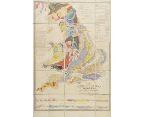
England & Wales. Greenough (George Bellas), A Physical and Geological Map of England & Wales by G.B.Greenough Esq. F.R.S., (on the basis of the original Map of Wm. Smith 1815) revised and improved under the superintendence of a committee of the Geological Society of London from the maps of the Geological Survey of Great Britain 1836 - 63..., published by The Geological Society, July 1865, engraved map with bright contemporary hand colouring, sectionalised and laid on linen on four sheets, calligraphic title and table of explanation, marbled endpapers, each sheet approximately 950 x 810 mm, contained in a modern purpose made marbled card slipcase with printed labels to spine and upper board This is the third state of Grennough's map and the first to acknowledge William Smith. Scarce. (1)
England & Wales. Walker (J. & C.), A Geological Map of England, Wales and part of Scotland, showing also the Inland Navigation with the Railroads & Principal Roads, published March 15th, 1838, engraved map with contemporary hand colouring, sectionalised and laid on linen, inset table of explanation, two horizontal geological profiles at base of map, 935 x 640 mm, contained in a contemporary cloth slip case with publisher's black and gilt label to upper board (1)

England & Wales. Saxton (Christopher & Lea Philip), Anglia, The Kingdome of England and Principality of Wales exactly described, circa 1693, hand coloured engraved map, elaborate strapwork cartouche, with a statistical table of the counties, some creasing and marginal closed tears, largely confined to lower left corner of map, this portion strengthened on verso, two small holes to upper margin but not affecting image, some dust soiling to margins, 390 x 490 mm Uncommon. (1)
![England & Wales. Ortelius (Abraham), Angliae Regni florentissimi nova descriptio auctore Humfredo Lhuyd Denbygiense, [1588],](https://cdn.globalauctionplatform.com/6f06c57b-9702-4210-a2e3-a7400109952d/c2321d23-44c5-48b3-855b-4be93ccac135/468x382.jpg)
England & Wales. Ortelius (Abraham), Angliae Regni florentissimi nova descriptio auctore Humfredo Lhuyd Denbygiense, [1588], hand coloured engraved map, large strapwork cartouche and mileage scale, central fold strengthened on verso, 380 x 465 mm, Spanish text on verso Marcel van den Broecke. Ortelius Atlas Maps, no.19. (1)

*England & Wales. Gillray (James), A New Map of England & France. The French Invasion; - or - John Bull bombarding the Bum-Boats, published H.Humphrey, 1793, [but H.G.Bohn impression, circa 1849], hand coloured etched caricature map, 345 x 250 mm, mounted, framed and glazed with Jonathan Potter Gallery label of authenticity to verso (1)
England & Wales. Walker (John), Map of the Inland Navigation, Canals, and Rail Roads, with the Situations of the various Mineral Productions throughout Great Britain, from actual surveys projected on the basis of the trigonometrical Survey made by order of The Honourable The Board of Ordnance..., published Richard Nichols, Wakefield, 1830, very large engraved map with contemporary hand colouring, sectionalised and laid on linen, inset map of Scotland, calligraphic title and dedication, table of explanation, edged in green silk, marbled endpapers, 1885 x 1540 mm A large and impressive map giving the location of mineral and rock deposits with each mine identified by the mineral it produces. It probably owes much to William Smith's ground breaking geological map of 1815. (1)
*England & Wales. Rocque (John), England and Wales drawn from the most accurate Surveys containing all the Cities, Boroughs, Market Towns & Villages..., published Laurie & Whittle, 1794, engraved map with contemporary outline colouring on four conjoined sheets, large uncoloured decorative cartouche, inset map of the Scilly Isles, old folds, 1180 x 1000 mm, framed and glazed (1)
England & Wales. Kitchin (Thomas), South Britain or England & Wales, Drawn from several surveys &c. on a new projection corrected from astronomical observations & the places marked where the observat.ns were made, 1769, engraved map with contemporary outline colouring, sectionalised and laid on linen, inset map of the Scilly Isles, large uncoloured decorative cartouche, compass rose and table of remarks, slight dust soiling and fraying to margins, ink manuscript ownership inscription (dated 1776 & 1811) to verso, 1275 x 1090 mm Uncommon. The large pictorial cartouche incorporates a coastal scene with a ship, a soldier and a sailor and a spread of artifacts representing British trades, including sheep, wheat and cannonballs. (1)
Ghana. The Gold Coast Handbook, 2nd edition, Accra: C. Fairweather, Government Printing Department, 1924, black & white plates, folding tables, numerous advertisement at rear, seven folding maps in rear pocket, original cloth, dust-soiled and extremities slightly marked, 8vo, together with Duse Mohamed (Duse, & Hutchison, W.F.), The West African Directory and Year Book 1920-21, London: Africa & Orient Review, [1921], black & white portrait frontispiece, advertisements at rear, original cloth, lower joint cracked, dust-soiled, 8vo, with four others including Chandler (Alfred D. & Sharp, Captain John C.), A Bicycle Tour in England and Wales, made in 1879 by the President of the Suffolk Bicycle Club, of Boston, Mass., published by A. Williams & Co., Boston, 1881, 4 folding maps and 17 photographic illustrations, original cloth gilt, 8vo and Jones (Rev. Harry), The Regular Swiss Round in Three Trips, 1865, double-page sketch map, 21 engravings, original cloth gilt; Defauconpret, Auguste-Jean-Baptiste, and Six Mois a Londres en 1816, Paris, 1817, modern half-cloth gilt, 8vo (6)

Essex. Speed (John & Norden John), Essex devided into Hundreds with the most antient and fayre towne Colchester described and other memorable monuments observed, published G.Humble, circa 1627, hand coloured engraved map, inset town plan of Colchester, two very small holes affecting image, 390 x 510 mm, English text on verso (1)

Europe. Lehmann-Dumont (Karl), Humoristische Karte von Europa im Jahre 1914, published Dresden, 1914, colour printed photolithographic allegorical map, inset map of Japan, old folds with small holes where folds cross, 350 x 490 mm An uncommon allegorical depiction of Europe, with the bias on Germany and Prussia. Undoubtedly published for amusement it concentrates on the national characteristics and the foibles of each nation, but there is also a more disturbing element of propoganda. The date of publication and the depiction of national stereotypes will prove to be highly prophetic of the carnage that was shortly to engulf the continent. (1)
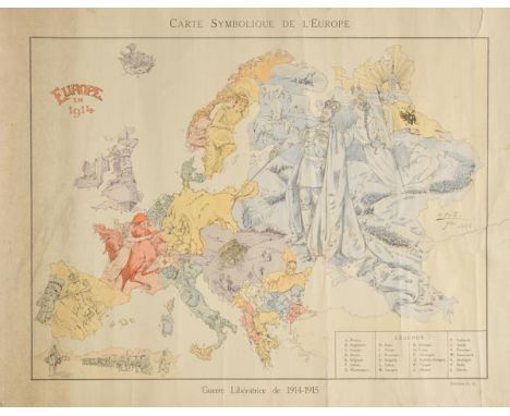
Europe. Cret‚ (B.), Carte Symbolique de L'Europe, Guerre Lib‚ratrice 1914 - 1915, published Paris, 1914, colour lithograph, old folds, slight fraying to margins, repaired closed tears affecting image, some splits to old folds, strengthened on verso, some dust soiling, slight creasing, 455 x 570 A satirical French map showing the state of Europe at the outbreak of World War I. Great Britain is represented by a dreadnought whilst Ireland sails a dinghy in the battleship's wake. An enraged German bull charges at the French cockerel and Marianne pokes at the bull with a short sword. At the same time the German bull is poked in its rump by an imperious Tsar Nicholas II of Russia. The representation of Austria-Hungary as a fallen crown and a series of graves is deeply prophetic, suggesting the impending end of that empire. Poland is a young girl pleading to Russia whilst Italy turns its back on the continent and plays a lute. Sweden and Norway are shown as beautiful young girls in an almost sapphic embrace. The map is a relatively gentle depiction of European national characteristics before the continent descended into chaos. Uncommon. (1)
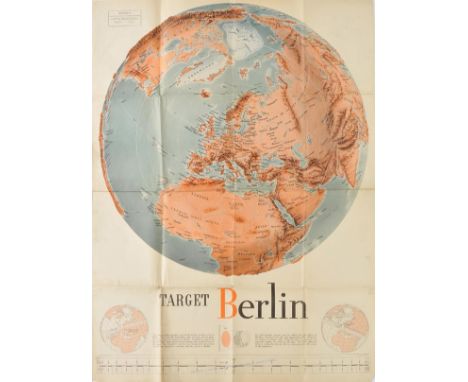
Europe. Manning (F.E.), Target Berlin, 'Newsmap', Prepared and Distributed by the Army Orientation Course. Special Service Division Army Service Forces, War Dept., 2E581 Pentagon Bldg., Washington D.C. U.S. Government, October 25, 1943, large photolithographic poster with detachable scale at base of map, old folds, slight dust soiling, 1190 x 890 mm, together with Lee (Kerry), London Town, Travel by Southern Region...., circa 1955, pictorial monochrome map published by Southern Railways, old folds, some tape staining to margins, 425 x 570 mm Kerry Lee produced two colour pictorial maps for British Railways in the 1930s which were revised up until the 1950s. These railway posters, very much in the style of Macdonald Gill were very popular and this folding monochrome example appears to be a re-issue of these earlier maps. (2)
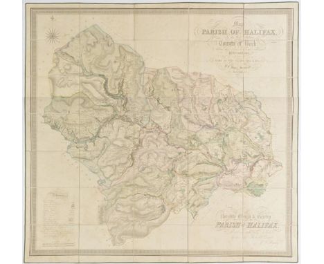
Halifax. Bryars (J.F.), Map of the Parish of Halifax in the West Riding of the County of York, shewing the Township, Borough and Manorial Boundaries from an actual Survey made in the Years 1834 & 1835 by J.F.Myars, Surveyor, Halifax, circa 1835, large scale engraved map with contemporary hand colouring, sectionalised and laid on linen, calligraphic title and dedication, compass rose and a table of references, some spotting, 1110 x 1160 mm, contained in a contemporary blue calf book box with gilt decorated spine, a little worn and bumped at extremities (1)

*Hampshire. Blaeu (Johannes), Hantonia sive Southantonensis comitatus vulgo Hant-Shire, published Amsterdam, circa 1650, engraved map with contemporary hand colouring, some water staining affecting image, toned overall, occasional marginal repaired closed tears, 425 x 510 mm, framed and glazed Not examined out of frame. (1)
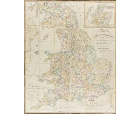
*Ireland. Wyld (James), A Map of Ireland divided into Provinces and Counties shewing the Great and the Cross Roads with the distances of the Principal Towns from Dublin. Also the Steam communications from the Out Ports and the average time of passage, 1854, engraved map with contemporary outline colouring, slight creasing, slight abrasion in margins, 720 x 550 mm, mounted, framed and glazed in a modern inlaid wood and gilt frame (1)

Guthrie (William). A New System of Modern Geography: or a Geographical, Historical and Commercial Grammar and present state of the several Kingdoms of the World, 4th edition, published C. Dilly and G. G. J. and J. Robinson, 1788, folding hemispheral map of the world frontispiece, engraved plate of an armillary sphere, and twenty-three (complete as list) engraved folding maps, all with contemporary outline colouring, some maps with closed handling tears, occasional spotting, hinges and joints weak, contemporary calf, heavily worn and frayed, large 4to Sold as a collection of maps, not subject to return. (1)

Japan. Bowen (Emanuel), A New and Accurate Map of the Empire of Japan laid down from the memoirs of the Portuguese and Dutch and particularly from the Jesuit Missionaries as published by the Sr. Bellin at Paris, circa 1750, uncoloured engraved map, decorative cartouche supported by oriental figures, 360 x 440 mm (1)
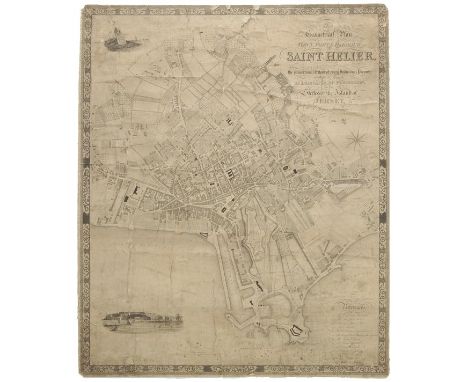
Jersey. Cobley (C., engraver), This Geometrical Plan of the Town, Fort & Harbour of Saint Helier exhibiting at sight the proportional extent of every individual property within its limits, is dedicated by permission to the States of the Island of Jersey by Elias Le Gros, Civil Surveyor, 1834, uncoloured engraved town plan, vignette of a view of the Harbour and Fort Regent, compass rose and calligraphic title, laid on linen, heavily creased, some spotting, dust soiling and staining, some marginal fraying and closed tears, small areas of loss, 820 x 690 mm Although in poor condition this is a scarce plan of Saint Helier and is probably the first large-scale map of the town. Only two copies found on COPAC. (1)
Leeds. Thorp (Joshua, surveyor), Map of the Town of Leeds and the country circumjacent, including Wakefield, Aberford & Castleford, shewing all the Townships, Foot Roads &c. made from actual Admeasurements during 1819, 1820 & 1821, published circa 1822, engraved map with contemporary outline colouring, sectionalised and laid on linen on four sheets, calligraphic title, table of explanation and uncoloured vignette of Kirkstall Abbey, overall size 1140 x 1210 mm, contained in contemporary card slipcase, worn and frayed (1)
Leicestershire & Rutland. Jansson (Jan), Leicestrensis comitatus cum Rutlandiae vulgo Leicester & Rutland Shire, published Amsterdam, circa 1650, engraved map with contemporary outline colouring, decorative cartouche and mileage scale, slight offsetting and staining, 445 x 555 mm, Latin text on verso, mounted, together with Comitatus Nottinghamiensis sive Nottinghamshire, published Amsterdam, circa 1650, engraved map with contemporary outline colouring, slight staining and offsetting, 385 x 485 mm, Latin text on verso, mounted (2)

London. Mylne (R.W.), Geological Map of London and its Environs, 3rd. edition, published Thomas Letts, circa 1871, engraved map with contemporary hand colouring, sectionalised and laid on linen, geological cross-section at base of map, 410 x 670 mm, bound in publisher's cloth gilt boards Uncommon. (1)


Minorca. Armstrong (John), A Correct Map of the Island of Minorca by John Armstrong Esqr. Engineer in Ordinary to his Majesty with many Additions and Improvements from the Late Surveys, Published R.H.Laurie, circa 1780, hand coloured engraved map, four inset maps of a general map of the Western Mediterranean, a map of Mahon harbour, a view of Mahon and a North East Prospect of St. Philips Castle, slight staining and dust soiling to margins, 445 x 555 mm (1)

Minorca. Basire (J.), Plan of the Town and Harbour of Mahon, St. Philip's Castle and its Fortifications, circa 1760, uncoloured engraved map, old folds, 370 x 625 mm Originally published in Nicholas Tindal's continuation of Rapin De Thoyras' "History Of England" (1744-1777). The atlas primarily contains maps depicting the military actions fought by the English during the campaigns of the War of the Spanish Succession, notably in the Low Countries, but also in Spain. (1)

Minorca. Valdes (Antonio), Carta Esferica de la Isla de Menorca presentada al Rey Nuestro Senor..., 1786, two uncoloured sea charts, engraved by J.Joacquin Fabregat and Moreno Texada, the first map with inset maps of the northern port of Fornells and the port and city of Ciutadella de Menorca, the first map with some spotting, creasing and slight dust soiling, each approximately 570 x 810 mm Uncommon sea charts. Vincente Tofi¤o de San Miguel surveyed the Balearic Islands between 1783 and 1788 under the command of Antonio Valdes. The charts appear to have been issued independently and then bound into various composite nautical atlases from about 1788. (2)

Hasselquist (Frederick). Voyages and Travels in the Levant; in the Years 1749, 50, 51, 52. Containing Observations in Natural History, Physick, Agriculture, and Commerce: Particularly on the Holy Land, and the Natural History of the Scriptures... Published, by Order of her present Majesty the Queen of Sweden, by Charles Linnaeus, 1st English edition, 1766, half title, folding engraved map (soiled along one fold), erratic pagination, a few later manuscript cartoons to endpapers and map verso, contemporary calf, a little rubbed, 8vo Blackmer 792: "The first systematic natural history of the Holy Land". Hasselquist was a student of Linnaeus, and after his early death, his old teacher edited and published this account, with a short biography. Hasselquist travelled in Syria, Palestine, Egypt and Cyprus, and describes the fauna and flora he found there; the final part made up of his letters to Linnaeus, written 1749-51 from Cairo and from Smyrna, where he died in 1752. (1)

New Zealand. Benard (Robert), Carte de la Nle. Zelande visit‚e en 1769 et 1770 par le Lieutenant J.Cook Commandant de L'Endeavour Vaisseau de sa Majest‚, published Paris, [1774], uncoloured enrgaved map, old folds, small stain to lower right of map, 390 x 385 mm Originally published in Hawksworth's 'An Account of the Voyages..., in the Southern Hemisphere'. (1)
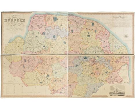
Norfolk. Bryant (Andrew), Map of the County of Norfolk from Actual Survey by A.Bryant in the Years 1824, 1825 and 1826, Respectfully dedicated to the Nobility, Clergy & Gentry of the County, published A.Bryant, Dec. 1st. 1826, large scale engraved folding map on two sheets, bright contemporary hand colouring, sectionalised and laid on linen, calligraphic cartouche, list of the ecclesiastical divisions, compass rose, table of explanation and uncoloured engraved vignette of Norwich Cathedral, bordered with green silk, each sheet approximately 740 x 2270 mm, contained in contemporary gilt calf solander box, rubbed, bumped and worn T.Chubb. A Descriptive List of the Printed Maps of Norfolk 1574 - 1916, page 106. (1)
Reference. A mixed collection of approximately 120 map reference books, dealers and auction catalogues, mostly 20th century including reference books and facsimile atlases with examples by Batten & Bennett, Tooley, Skelton, Worms & Baynton- Williams, Foxell, King, Moreland & Bannister and Arlott, together with approximately forty dealer catalogues, including examples by Peter Harrington, Bernard Shapero, Daniel Crouch, Jonathan Potter and Philip Burden and approximately forty auction catalogues on maps, atlases and natural history from Bonhams and Sothebys, various sizes, mostly in very good condition, plus twenty-three Archive CD books on maps and atlases (approx.140)
Scotland & Wales. Jansson (Jan), Orcadum et Schetlandiae Insularum accuratissima descriptio, published Amsterdam, circa 1650, engraved map with contemporary outline colouring, some offsetting and staining, 380 x 495 mm, Latin text on verso, mounted, together with Ceretica sive Cardiganensis comitatus Anglis Cardigan Shire, published Amsterdam, circa 1650, engraved map with contemporary outline colouring, some offsetting and staining, central fold partially split and strengthened on verso, 385 x 505 mm, Latin text on verso, mounted (2)
![Scotland. Ortelius (Abraham), Scotiae Tabula, [1584], hand coloured engraved map orientated to the west, 360 x 485 mm, Latin](https://cdn.globalauctionplatform.com/6f06c57b-9702-4210-a2e3-a7400109952d/e04e2190-b247-4d35-ceed-5c5acc7d90da/468x382.jpg)
Shropshire & Staffordshire. Jansson (Jan), Salopiensis comitatus cum Staffordiensi. Shropshire & Staffordshire, published Amsterdam, circa 1650, engraved map with contemporary outline colouring, decorative cartouche and mileage scale, slight offsetting and staining, 430 x 535 mm, Latin text on verso, mounted, together with Herefordia comitatus vernacule Hereford Shire, published Amsterdam, circa 1650, engraved map with contemporary outline colouring, slight staining and offsetting, 385 x 505 mm, Latin text on verso, mounted (2)

Spain. Nolin (Jean Baptisite), Les Royaumes de Valence et Murcie tirez de Cantel..., published Paris, 1762, engraved map of South-eastern Spain, contemporary outline colouring, inset map of the Balearic Islands, title repeated in Spanish, 575 x 440 mm, together with Homann (Johann Baptist), Portugalliae et Algarbiae..., published Nuremberg, circa 1730, engraved map with contemporary outline colouring and some later enhancement, inset map of Brazil, slight dust soiling, margins and central fold strengthened on verso, 495 x 570 mm, with Seale (R.W.), A Map of the Kingdoms of Spain and Portugal from the latest and best observations for Mr Tindal's Continuation of Mr Rapin's History, circa 1770, uncoloured engraved map, old folds, 385 x 470 mm (3)
-
109198 item(s)/page