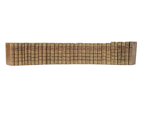

JESUIT MISSIONSLettres édifiantes et curieuses écrites des missions étrangères, par quelques missionnaires de la Compagnie de Jésus, 34 vol. bound in 32, engraved title vignettes, 36 mostly folding engraved plates and maps (of 38, without portrait of Antoine Verjus, and map of Paraguay, 2 hand-coloured, a few old repairs at folds, some loss to map of 'Nouvelles Phillipies' in volume 6, and plate of Chinese inscriptions in volume 10), occasional light foxing or browning, volume 1 with title shaved at lower margin touching imprint, and final leaf repaired with some loss of text, volume 5 with small loss to blank corners on 2 leaves, volume 15 title with small hole touching imprint, volumes 1-28 uniform contemporary calf, spines gilt in compartments with two lettering-pieces, red edges, volumes 29-34 (slightly taller) in similar mottled calf, some rubbing and abrasions, minor worm trails to a few sides and joints, a few spine ends chipped, but generally attractive [Sabin 40697, 'a set comprising the first edition of each volume is of uncommon rarity'; Sommervogel III, 1514, IV, 34-35, V, 536, VI, 353-354; cf. Hill 1024, second edition only], 8vo, Paris, Jean Cusson [and others], 1702-1776Footnotes:RARE COMPLETE SET OF 'THE MOST VALUABLE 18TH-CENTURY SOURCE ON JESUIT ACTIVITIES IN FRONTIER REGIONS THROUGHOUT THE WORLD' (Hill, Collection of Pacific Voyages).This monumental series, began under the editorship of Charles le Gobien, was intended to provide a history of Jesuit missions and news from China. Subsequently accounts of many Company of Jesuits missionary missives from all the regions of their activities were added, with information on science, medicine, natural history, technology and geography as well as theological matters. Following le Gobain the editorship passed to Jean-Baptiste du Halde, a great proponent of Jesuit science as a means to winning imperial favour in China, and thereafter under several other editors until the final volume was published in 1776.Provenance: 'Domus probationis Parisiensis Societatis Jesu ad usum novit', contemporary inscription on the title of volume 1, and and similar inscriptions to titles of volumes 2-28, placing these volumes formerly in the library of the Parisian Jesuit novitiate.This lot is subject to the following lot symbols: •• Zero rated for VAT, no VAT will be added to the Hammer Price or the Buyer's Premium.For further information on this lot please visit Bonhams.com
We found 108737 price guide item(s) matching your search
There are 108737 lots that match your search criteria. Subscribe now to get instant access to the full price guide service.
Click here to subscribe- List
- Grid
-
108737 item(s)/page


After James Cochrane Junior - Print map of the Island of Guernsey, 20th cenntury, likewise all of the Adjacent Rocks, Shoals & Passages, with the Tides, Soundings, Anchorages &c.', dedicated to Lord de Saumarez, Vice Admiral of Great Britain, with vignette of the Royal College of Elizabeth, 15½ x 18½in. (39.4 x 47cm.), framed, glazed and mounted.


A collection of Channel Islands books, comprising of Ewen & De Carteret - The Fief of Sark; Warburton - L'Histoire, Les Lois et Institutions; Inglis - The Channel Islands - 1834, 2 vols, lacks one map; Carey, Laurent - Essai sur les Institutions, Lois et Coûtumes de I'lle de Guernesey, 1899, together with many others to include Michael Marshall - criminal Law of the Bailiwick of Guernsey etc. (large quantity)


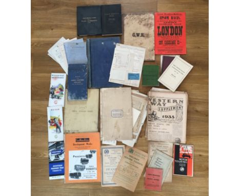
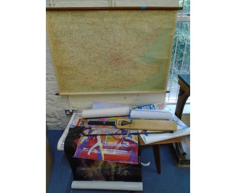
Railwayana - GWR Great Western Railway - a collection of ephemera, embossed binders, books, maps, receipts etc., Weymouth & Channel Islands Steam Packet Company' receipts, dating 1860s onwards; a G.W.R Special Centenary Number binder, dating 30th August 1935; various other binders; a Great Western Railway - Road Interests map; a G.W.R Analysis Book with map, 1926; a Map of this Great Western Railway and its Connections, early 20th century; a Telegraph Message Code book, 1st July, 1939; a Great Western Railway Deed Dept. folder with quantity of receipts, 1930s onwards; a Great Western Railway 'Epsom Races' poster, May 1968(?); various other ephemera; newspapers etc. (very large quantity)
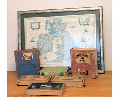
Railwayana - Chad Valley GWR Great Western Railway - boxed jig-saw puzzles, comprising Glorious Devon; The Streamlined Way; Brasenose Collage Oxford; Drake Goes West; St. Julien; and The Cornish Riviera Express; together with a framed puzzle map of the Great Britain, boxes a/f, unknown if complete. (7)
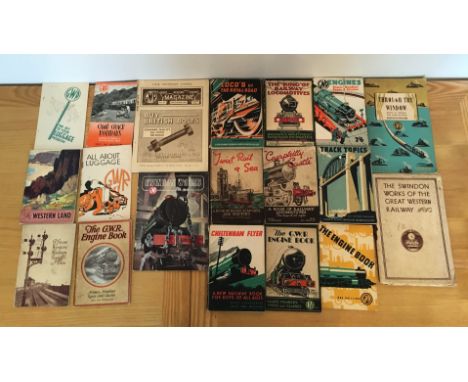
Railwayana - GWR Great Western Railway - Books, comprising Track Topics; The 'King' of Railway Locomotives; Locos of 'The Royal Road'; Caerphilly Castle; Twixt Rail & Sea; Cheltenham Flyer; Engines, Names Numbers Types & Classes; Through the Window; A Great Western Railway Signal-Box, with fold out map; The G.W.R Engine Book x 3 etc. (quantity)

Second World War Guernsey interest - A large collection of Red Cross Letters (142) - " Interniertenpost " letters - Ephemera etc - some Biberach, A large collection of various ephemera mostly related to Mrs Jeremie, being sent to various Guernsey residents etc, to include 142 Red Cross letters dating 1940-1945; Interniertenpost letters and various other letters and telegrams, some stamped Biberach; Prisoner of War Camps map; War Organisation of the British Red Cross Society and Order of St. John of Jerusalem, Prisoners of War Department - Information about letters for Civilians interned in Germany or German-Occupied Countries information sheets; ration books etc. (very large quantity, mostly in very good condition)


Escape to Persia hardback book by Katherine Hull and Pamela Whitlock. With dust jacket 1941 second impression. Inscribed 1943 inside map page, some age signs but reasonable condition. Sold on behalf of the Michael Sobell Cancer Charity. We ship worldwide and combine shipping on multiple lots to keep costs as low as we can.

The Far Distant Oxus hardback book by Katherine Hull and Pamela Whitlock. With dust jacket, which has some paper loos on top of spine. Inscribed 1942 inside map page, some age signs but reasonable condition. Sold on behalf of the Michael Sobell Cancer Charity. We ship worldwide and combine shipping on multiple lots to keep costs as low as we can.

A History of the Reigning Family of Lahore, with some account of the Jummoo Rajahs, the Seik soldiers, and their Sirdars, by Major G. C. Smyth W. Thacker & Co., Calcutta, 1847with five plates, folding lithographed map of Lahore and family tree of Maharajah Ranjit Singh, dedication inscription by the author, 19th Century calf and marbled boards 8vo. (225 x 145 mm.)This lot is subject to the following lot symbols: •• Zero rated for VAT, no VAT will be added to the Hammer Price or the Buyer's Premium.For further information on this lot please visit Bonhams.com

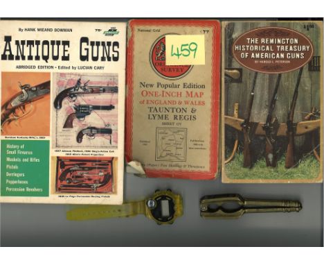
Glory bag collection includes Metal Nutcracker, Digital watch with compass, Vintage Map Taunton and Lyme Regis, The Remington Historical of American Guns book and Antique Guns by Hank Bowman softback book. Good condition We combine postage on multiple winning lots and can ship worldwide. UK postage from £4.99, EU from £6.99, Rest of World from £8.99


A pair of German boots, dated 1941, together with a selection of other items to include a British map case, German belt and buckle, WWII period equipment suspenders, 2 x Mosin ammo pouches, British Binoculars, Browning holster, brown leather holster, Webley Holster with cleaning rod and a MG42 sling (parcel) possible reproduction, please form own opinion before bidding


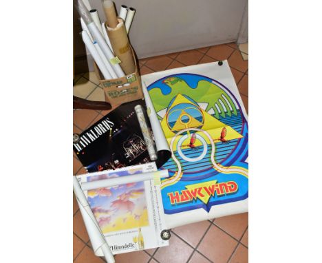
POSTERS, MUSIC AND MISCELLANEOUS, fifteen poster to include Motorhead - Overkill Rush - Permanent Waves, Barclay James Harvest - Eyes of the Universe, Steeleye Span - Storm Force Ten, HAWKWIND - Love & Peace, a Pauline Baynes Map of Middle-Earth and a palestinian Liberation Organization (PLO) poster

A GEORGE III OVAL NEEDLEWORK SAMPLER OF A MAP OF THE COUNTIES OF 'ENGLAND AND WALES', fine linen worked with silk, the bottom edge stitched 'THE WORK OF ELIZA BRAWN 1792' 51cm x 44cm in a gilt frame and glazed, frame s.d., the sampler has areas of staining and age discolouration, some splits around the edges

A SILVER COMPACT AND ONE OTHER, the silver compact of a square form, engine turn design, opens to reveal powder compartment and a square mirror, hallmarked London, approximate dimensions 62.8mm x 62.4mm x 9.8mm, approximate gross weight 90.6 grams, together with a round compact engraved with a map of India, opens to reveal a mirror, stamped 'Sterling silver', approximate gross weight 95.5 grams

Bartholomews Football History Map: Very large map with the club badges to one side and team kits on the actual map of England and Wales. Produced in the early 70s and 50 years on still in very good condition. Folds very small and opens up to 39 x 30 inches. Kids used to put these on the wall. Instructions to sell.

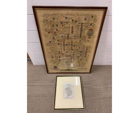
John Cary (1754-1835) British, an outline hand colouring county map of Staffordshire, published by John Cary, London c.1820, for his "Traveller's Companion" or " A Delineation of the Turnpike Roads of England & Wales", acording label verso. Features include a compass rose surmounting the title plate, Rivers and Navigable Canals, Turnpike roads, the Seats of Nobility & Gentry coloured green with the routes of the Mail Coaches in blue, beneath the map are the distances in miles of Central London from the main towns of the county, framed and glazed, (15.5x10.5 cm), together with a French print, "Arbre Genealogique des capetiens", also framed and glazed. (64x45.5 cm). (2)


2 handkolorierte Kuperstichlandkarten - 1 x "Oldenburg Comitatus", Landkarte Oldenburgs im Oldenburger Land. Original im Atlantenwerk "Theatrum Orbis Terrarum sive Atlas Novus" 1. Hälfte 17.Jh., Amsterdam, zu finden. Maße mit Rahmen 74 cm x 60cm. Alters- und Gebrauchsspuren infolge dunkler Verfärbungen, leicht stockfleckig, Flecke, Mittelfalz. 1 x "Le Duché de Cleves", Karte des Herzogtums Kleve. Original einst von Alexis Hubert Jaillot, Beginn 18.Jh. Maße mit Rahmen 74cm x 60cm. Alters- und Gebrauchsspuren durch Verfärbungen, Mittelfalz. | 2 hand coloured copper engraved maps - 1 x "Oldenburg Comitatus", map of Oldenburg in the Oldenburg region. Original in the atlas work "Theatrum Orbis Terrarum sive Atlas Novus" 1st half 17th cent. Amsterdam. Dimensions with frame 74 cm x 60cm. Signs of age and usage due to dark discolouration, light foxing, stains, centrefold. 1 x "Le Duché de Cleves", map of the Duchy of Cleves. Original map from Alexis Hubert Jaillot, beginning of 18th cent. Dimensions with frame 74cm x 60cm. Signs of age and usage due to discolouration, centrefold.


-
108737 item(s)/page