We found 109182 price guide item(s) matching your search

Refine your search

Year

Filter by Price Range
  • List
  • Grid
  • 109182 item(s)
    /page

Lot 329

HODGES, William : Travels in India, During the Years 1780, 1781, 1782, and 1783,large folding map, 14 plates, cont. full calf expertly rebacked, 4to, 1794.

Lot 296

BORLASE, William - Antiquities, Historical and Monumental, of the County of Cornwall,: folding map, another map & 25 engraved plates etc., cf. gt., fo., 2nd edn. 1769.

Lot 693

WHITTAKER, G & W.B - Devonshire : hand coloured map, 180 x 105 mm, framed & glazed, early 19th cent. With - Moule, Devonshire, & Tallis, Environs of Plymouth. (3)

Lot 361D

ROWE, Samuel - The Panorama of Plymouth,: folding map, orig. publs. bds., 8vo., 1821.

Lot 691

VISSCHER, Nicolaus - Magnae Britanniae : hand coloured map, 560 x 465 mm, f & g, c1690.

Lot 583

A FOLDING MAP OF THE CHINA COAST and Rough Sketches of the Provinces lying between Canton & Pekin,: compiled and drawn by J.O.N. James, assistant surveyor and principal draftsman, Surveyor General's Office, Calcutta, on 24 linen-backed panels, 113cm x 104cm, in morocco folder, 1859.

Lot 338

LYSONS,, Rev. Daniel & Samuel - Magna Britannia Volume the Third containing Cornwall,: folding map & 38 plates as listed, cf., 4to., 1814.

Lot 378

TUKE, John - General View of the Agriculture of the North Riding of Yorkshire,: folding hand-tinted map, 14 engraved plates etc., calf, 1800

Lot 473

FAYRER, J. - The Royal Tiger of Bengal his Life and Death,: Illustrated with folding map etc., cl., 8vo., 1875; STEWART, Col. A.E. - Tiger and Other Game, Illustrated with photographs, cl., 8vo., 2nd. edn. 1928 (3)

Lot 300B

CARRINGTON, H.E. - The Plymouth and Devonport Guide,: Ill. folding map & engraved plts., 4th edn. 8vo., n.d.

Lot 644

KITCHEN, Thomas - Devonshire : hand coloured map, 210 x 180 mm, framed and glazed. c1780s.

Lot 648

LEWIS, S : Lewis's Atlas comprising the Counties of Ireland, cloth, eng. title, eng. contents list, fold gen. map, 32 COUNTY MAPS, 4to, 1837

Lot 346

PARKE, Thos. Heazle : My Personal Experiences in Equatorial Africa - 18 plates, fold map in rear pocket, org. cloth, 8vo, [second ed], 1891.

Lot 628

HOLE, William - Hamshire (Hampshire),: hand-coloured map, 320 x 295mm., possibly laid down., c.1607, framed and glazed; with one other facsimile map. (2)

Lot 684

SPEED, John - Devonshire,: a hand-col. map, 51 x 39cm. by John Sudbury & George Humble, f & g, c. 1623,

Lot 685

SPEED, John - Wight Island (Isle-of Wight),: hand-coloured map, 505 x 385mm., English text, c. 1627, framed and glazed.

Lot 686

SPEED, John : The Kingdome of Irland [Ireland], hand coloured map, 505 x 385 mm, Sudbury & Humble, English text on verso, f & g, 1610 [or later].

Lot 380

VALERY, Antoine Claude Pasquin - Historical, Literary, and Artistical Travels in Italy:, vignette title, folding map, vellum, 8vo., 1842; together with a group of 9 other similarly-bound works,

Lot 297

BORLASE, William - The Natural History of Cornwall,: folding map and 28 engraved plates, later hf. cf., fo., 1758.

Lot 678

SELLER, John - Devonshire : hand coloured map, 145 x 110 mm, framed & glazed, c1694.

Lot 537

A group of letters from Irish and other politicians including the Earl of Erme, the Earl of Portsmouth, Walter Limbrick, Alpheus Morton etc.:, Letts Map of the Nile and an Ordnance Survey map.

Lot 288

BARTHOLOMEW, John - Philips' Handy Atlas of the Counties of Ireland,: 33 maps, cloth, 8vo., 1882; Map of England and Wales by The Chart Publishing Co., Oxford, in 2 folding sections with index volume, s.-c.; together with a group of 20th century road and other maps. (16)

Lot 495

Thomas Kitchen, 'A New Map of South Wales', uncoloured. Framed and glazed.

Lot 170

Vintage London map with tram routes

Lot 826

McDOWALL (W.) - HISTORY OF THE BURGH OF DUMFRIES second edition, illustrated with folding map, gilt tooled calf, 1873

Lot 427

A boxed map reader compass with magnifying glass.

Lot 1366

Egypt, Arab Republic (1971-), AV Pound, 1982 / AH1402, commemorating the Liberation of Sinai, dove of peace with outstretched wings above map of Sinai within a 'v', rev. ornamental legend (KM.-; Fr.83)uncirculated Subject to 20% VAT on Buyer’s Premium. For more information please view Terms and Conditions for Buyers.

Lot 157

Falkland Island Dependencies. 1946 1d Thick Map, fine used with Pl. 1 R3/9 extra island. SG G2aa (£200)/CW 34B

Lot 251

A 17th century Speede map of Warwickshire, double sided and hand coloured, 39 x 51 cm, in a Hogarth glazed frame

Lot 250

An 18th century Morden map of Staffordshire, hand coloured, 43 x 37 cm, in a Hogarth glazed frame

Lot 409

A Scrimshaw worked cow horn powder flask, bearing a naive river and fort map, detailing Fort Hunter, Fort Henry and others and the legend 'A Pox on the French Dogs, One and All' with ebony stopper and leather strap, 30cm

Lot 333

LATE NINETEENTH CENTURY BOUND VOLUME OF 521 SMALL SCALE MONOCHROME MAPS. COUNTIES OF ENGLAND AND WALES, paper on linen with reference/index to the numbered maps, showing canals, navigable rivers and railroads, each folding map approx 9 1/2" x 7" (24cm x 18cm) and a COPY OF WHITAKERS ALMANACK 1889 spine tatty (2)

Lot 358

Namiki. A sterling silver Namiki, AD 2000 Iubilaeum (Jubilee) zodiac limited edition fountain pen, featuring the constellations etched into a map of the heavens. 15 cm. Medium inlaid 18 K gold nib. Includes original packaging, papers and inkwell. Limited Edition: 0263/400.

Lot 450

Three maps, an 18th. century Owen and Bowen road strip map through Bruton, Bridgewater and Devizes , an 18th century map by J. Russell of South America and an early 19th. century map of Germany.

Lot 189

RAILWAY INTEREST: A BRITISH RAILWAYS 'SOUTHERN ELECTRIC' POSTER 'Visit Lewes, the Historic County Town of Sussex', depicting a stylised map by John Skelton, 1950, circa 40" high x 25" wide

Lot 400

1916 March 27 long envelope (with advertisement for "Campanilla" honey) to Bermuda, franked with Cuba Map 2c tied by barred oval and Holguin cds alongside, circular HAVANA "T" CUBA and circular CENTIMES 50 h/s's on the front also circular P.C. BERMUDA h/s (CM15) in violet and double ring oval POSTAGE/3D/Due in black, on the reverse if a full advertisement "Honey, Honey - D.W. Millar, Holguin, Cuba and Hamilton Bermuda arrival cds dated 7 April 1916, unusual

Lot 614

1946-49 Map thick and coarse 3d black and blue horizontal pair from the right of the sheet, the first with variety 'Extra Island' (SG G4aa) large part o.g., fine and scarce, cat £225

Lot 643

World War II: Civil Censorship: 1943 September 22, envelope from Suva franked 2½d Map tied by cds with another strike below, addressed to a Fijian serving with the United States Forces at APO 709 based at Guadalcanal in the Solomon's and showing fine strike of the rare framed "NOT CENSORED/IN FIJI" handstamp (Type H4), Ex Prestige (02/09/06, lot 1015). Illustrated by Alford on page 163 and by Little on page 114 although he has serious doubts as to it being genuine. Necessarily offered 'as is'

Lot 683

1938-55 6d black 'Map' (Die I) (SG 260) marginal block of four from the foot of the sheet with complete De La Rue imprint, the upper two large part o.g., the lower two u/m, light overall gum toning as usual otherwise fine, cat £240+

Lot 849

Collection in nine albums with good range of u/m blocks of four and fdcs (not complete) from the Inauguration of Republic in 1950 to 1982 incl 1958-63 'Map' set of 18, mostly fine also a few used throughout (Many Hundreds)

Lot 783

Large etched copper plate depicting 'World map circa 1786' 88cm x 149cm

Lot 615

Fourteen hand painted lead model figures of Rangers, probably Britains, together with an assembly of seventeen First World War Tommys to include figures with Tommy guns, a figure studying a map, etc

Lot 714

A coloured map showing the Bordeaux and Medoc regions of France and the Principality of Bern, Switzerland, inscribed bottom right Pierre Mariette and A Peyrounin, with date 1646, 39 x 49 cm approx together with a reproduction map of Russia after Anthony Jenkenson and a further 17th century map after Christopher Saxton showing the county of Worcestershire, 30 x 34 cm approx, all framed
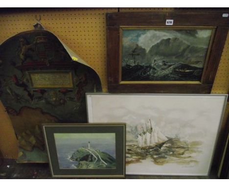
Lot 781

A collection of 19th century auction posters relating to farms, lands and sundry buildings for the Hawksbury Upton Upton district of Gloucestershire, dated between 1889 and 1891 including a map detailing a number of the lots

Lot 670

An oil painting on canvas laid onto board of a 19th century naïve style a stormy scene with lifeboat approaching a stricken vessel, 27 x 43 cm in wooden frame with gilt slip together with an oil painting on canvas in the 16th century manner showing a section of a map with royal coat of arms, sea creatures, etc, 86 x 61 cm approx, unframed, a watercolour of a coastal scene with lighthouse, signed Edward Wood and a signed limited edition print of a sailing vessel at high seas

Lot 700

Rocque's Map of Surrey 1762 (published in facsimile by the Surrey Archaeological Society 1931) together with a quantity of further unframed 18th and 19th century maps including The Lakes of Cumberland, Westmorland and Lancashire, country maps including Huntingdonshire, Brecknockshire, Staffordshire, Worcestershire, etc

Lot 664

A black and white printed map showing The Breweries of Britain, inscribed Arthur L L Hopkin and dated December 1951, 68 x 51 cm approx in simple black frame

Lot 800

A panoramic map of the River Thames from Oxford to London including Bacons birds eye view of the river, 5th edition, laid on canvas

Lot 179

A Framed Map of Lancashire.

Lot 525A

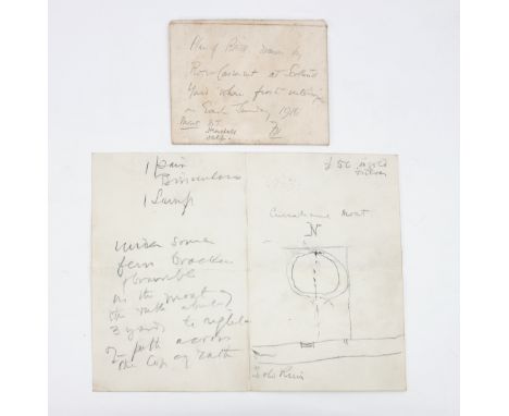
An original sketch-map in Roger Casement's hand, showing the location of items he and his companions had hidden after landing from the German U-boat U-19 on Banna Strand, County Kerry on Good Friday, 1916. Two facing pages 8vo, on blind-stamped paper of the Metropolitan Police Office (Scotland Yard), with Casement's directions to the cache ('Under some fern bracken & bramble in the moat...'). The only things mentioned are '1 pair Binoculars' and '1 Lamp; the words '£50 in gold & silver' may be in a different hand, probably that of one of his interrogators, Major (later Colonel) Frank Hall. With contemporary envelope in Hall's hand; 'Plan of RATH drawn by Roger Casement at Scotland Yard when first interrogated on Easter Sunday 1916. Present B[asil] T[homson]/Herschell/Self. FH'. Accompanying Casement's map is a later note written in ink by Frank Hall on a small slip, which gives details of the distribution of the cache after it had been retrieved. It is known that three Mauser pistols had been discovered when Casement was arrested in Ireland, and F E Smithin his account of the trial of Casement has it that 'Bailey buried there some wepons, some maps of Ireland of foreign origin and three coast, one of which contained Casement's diary', but this documents gives a fuller pictuire. 'His binoculars were given to Basil Thomas/Gold sleeve links to DI Cheesman/'Flag of Irish republic' to R I C mess Phoenix Park/Cash to Sgt. & Constable R I C/3 mauser pistols to me. I gave one to [Major Ivor] Price who used it at Connie Marciewitz [sic] at the Castle & missed her' and a copy of the Easter Rising surrender document given to Frank Hall by E W Pearson/see illustration

Lot 938

A 17th century hand coloured Dutch map of Hampshire by G. Blaeu, 'Hantonia Sive Southantonensis Comitatus Vulgo Hantshire', 42 x 50 cm framed and glazed Condition Report very good, faint centre vertical fold crease, a few other minor creases, no foxing, bright, wide margins all-round

Lot 1219

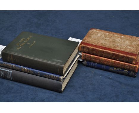
Render (Wilhelm) A Tour through Germany, 2 vols, 8vo, half leather, 1801; Williams (E.A.) The Cruise of the Pearl Round the World, 12mo, cloth, frontispiece, 1859; Clay (J.) My Life on the Range, 8vo, cloth, photographic portrait and plates, Chicago, 1924, presentation copy inscribed by the author; Chapman (F.S.) Northern Lights, 8vo, cloth, photographic frontispiece and plates, map, 1934, and one other. (6)

Lot 2

Thomas Kitchin (1718-1784) "An accurate map of the County Palatine of Durham" engraving from the Large English Atlas with hand-colouring 52.5 x 69.5cms; 20 5/8 x 27 3/8in. (plate size), unframed.

Lot 1154

Ross (M.) Architectural and Picturesque Views in Newcastle upon Tyne, 4to, half morocco, engraved map, additional title and plates, Newcastle upon Tyne, 1841.

Lot 1165

Dixon (David Dippie) Upper Coquetdale, 8vo, cloth, plates & illustrations, Newcastle upon Tyne, 1903; Guthrie (J.) The River Tyne, 8vo, cloth, frontispiece, plates, folding maps, Newcastle upon Tyne, 1880; Palmer (W.J.) The Tyne and its Tributaries, large 8vo, cloth, frontispiece, plates & illustrations, 1882; Johnson (R.W.) The Making of the Tyne, 8vo, cloth, frontispiece, map, plates, illustrations, London & Newcastle upon Tyne, 1895, and one other. (5)

Lot 1188

Crawfurd (George) A General Description of the Shire of Renfrew... Continued to the Present Period, by George Robertson, 4to, half calf, engraved frontispiece and plates, hand-coloured folding map, Appendix at end, Paisley, 1818, bookplate of John Heron Maxwell Shaw Stewart; Lang (A.) Prince Charles Edward, 4to, half morocco, t.e.g., coloured frontispiece portrait, plates, copy no. 354 of 1500 on fine paper, London, Paris, New York & Edinburgh, 1900. (2)

Lot 1

Emanuel Bowen and Thomas Kitchen (1694-1767 and 1718-1784) "An accurate map of Cambridgeshire divided into its hundreds" engraving, published 1753 with hand-colouring 70 x 51cms; 27 1/2 x 20in. (image size).

Lot 1119

Wood (Herbert Maxwell) The Registers of Whitburn, 8vo, half morocco, Sunderland, 1904, with James Patterson's Extracts from Whitburn Parish Registers bound at the end; Eboracum: of, the History... of ... York, vol. 1 only (of 2), 8vo, half roan, folding map, plates, York, 1788. (2)

Lot 1129

Brand (John) The History and Antiquities of the Town and County of the Town of Newcastle upon Tyne, 2 vols, 4to, contemporary calf gilt, engraved portrait, frontispiece, title-pages, map and plates (some folding), 1789, bookplate of Thomas Weld, Lulworth Castle.

Lot 1143

Cox (T.) 'Northumberland', extracted from Magna Britannia et Hibernia, 4to, calf-backed boards, folding engraved map and mileage chart, [1724], bookplate of Gerard F, T. Leather; Warner (Richard) A Tour through the Northern Counties of England, and the Borders of Scotland, vol. II, 8vo, old boards, wood engraved maps, Bath & London, 1802. (2)

Loading...Loading...
  • 109182 item(s)
    /page

Recently Viewed Lots