We found 109198 price guide item(s) matching your search
There are 109198 lots that match your search criteria. Subscribe now to get instant access to the full price guide service.
Click here to subscribe- List
- Grid
-
109198 item(s)/page


![[Hughes, Thomas]. Tom Brown at Oxford, new edition, London & New York: Macmillan and Co., 1871, inscribed by the author '](https://cdn.globalauctionplatform.com/9d88dee8-be88-44ca-9a35-ad3600da6ce4/e285b2a0-2c64-41da-8ca6-ad4900d18b98/468x382.jpg)
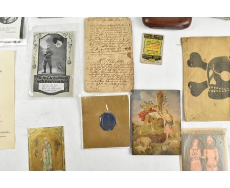
Lot 443
[Hughes, Thomas]. Tom Brown at Oxford, new edition, London & New York: Macmillan and Co., 1871, inscribed by the author 'Sybil Irene Cutler with the best wishes of her Godfather the author 1873' to preliminary blank (with later small ink ownership stamp to upper corner of leaf), half-title, vignette title, black & white plates with minor dampstaining to blank margins, a few scattered spots at front, hinges cracked, all edges gilt, together with: Ibid. Alfred the Great, new edition, London: Macmillan & Co., 1873, inscribed by the author 'Sybil Irene Cutler with the best wishes of her Godfather the author 1873' to preliminary blank (spotted and with later small ink ownership stamp to upper corner of leaf), frontispiece map, black & white plates, front hinge cracked, all edges gilt, both in uniform contemporary red morocco gilt, rubbed with some wear to extremities, spines and board edges darkened, some staining (mainly to spine areas), Alfred somewhat marked, 8voQty: (2)
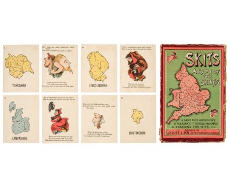
Lot 452
* Anthropomorphic map cards. Skits, A Game of the Shires, London: Jaques & Son, circa 1900, 80 cards (complete), comprising 40 numbered county map cards, and 40 accompanying cards with each county pictured as a person, animal, or object, each with verse, some light spotting and a few marks, and no. 25 (Monmouthsire map) with vertical crease to right-hand side, but edges crisp, pale green versos, 76 x 57mm, lacking 4pp. rule leaflet (supplied in facsimile), contained in original cardboard box with pictorial label on front, some wear to edges, with one hinge splitting, and top edge detached on 3 sidesQty: (1)NOTESExtremely rare. With verses such as: 'Dear Cantabs, old Sambo's our brother,/So every harsh thought we should smother;/Though dark his complexion/He votes at th'election;/Then let us all love one another' and 'What a boon is a notch on the nose/Where the arch of the spectacles goes;/This Staffordshire belle/Its convenience can tell,/For her pince-nez ne'er loses its pose'.
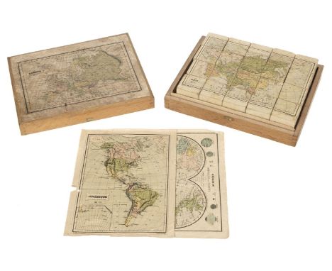
Lot 455
* Victorian Map Block Puzzle. A boxed set of map puzzle blocks, Paris: Charles Verneau, late 19th century, six hand-coloured lithographed maps: Mappemonde, Amerique, Europe, Asie, France, Afrique, dissected and laid on the faces of 20 wooden cubes, dust-soiled and rubbed, some light marks or stains, adhesive starting to fail in places, some edge wear, one section of Amerique with loss, one section of Asie repaired, with two (of 5) loose guide maps (plus Europe map adhered to box lid), dust-soiled and edge-frayed, Amerique map with two longer closed tears, contained in original wooden box, with 'Paris' engraved on the clasp remnant, lacking hinges and clasp, map on lid rubbed and stained, 19 x 24 x 5.5 cmQty: (1)

Lot 456
* World Map Board Game. The Crystal Palace Game, a Voyage Round the World, an Entertaining Excursion in Search of Knowledge, whereby Geography is Made Easy, by H[enry] S[mith] Evans, FRGS, published by Alfred Davis & Co., 58, 59 & 60, Houndsditch, London, [1855?], hand-coloured wood-engraved map of the world, presented as a board game and illustrated with the scenes depicting different activities around the world, sectionalised and laid on linen, some old damp staining with resultant tide lines, 49.5 x 67.5 cm, framed and glazedQty: (1)NOTESScarce. According to Megan A. Norcia, Gaming Empire in Children's British Board Games, 1836-1860, Routledge, 2019, page 23 '... though Evans' Crystal Palace Game seems to be about the 1851 exhibition, itself a display of the Empire's power and benevolence in developing arts and manufactures, the way Evans addresses this topic demonstrates that his game is really promoting British emigration and colonization by presenting opportunities to gain wealth in the colonies'.

Lot 521
Chatwin (Bruce). In Patagonia, 1977; The Viceroy of Ouidah, 1980; On the Black Hill, 1982; The Songlines, 1987; Utz, 1988, 1st editions, Songlines textblock a little toned, map endpapers to In Patagonia and Viceroy, original cloth, dust jackets, some fading to In Patagonia and On the Black Hill spines, 8vo, together with 15 others by Chatwin including The Morality of Things, 1993 (limited edition of 175), The Attractions of France, Colophon Press, 1993 (limited edition 77/175) What Am I Doing Here, 1989, Photographs and Notebooks, 1993, and Anatomy of Restlessness, 1996Qty: (20)

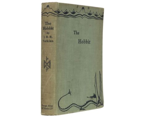
Lot 549
Tolkien (J.R.R.) The Hobbit or There and Back Again, 1st edition, 2nd impression, London: George Allen & Unwin, 1937, colour frontispiece, colour and monochrome plates and illustrations, map endpapers (slightly toned), original green pictorial cloth, spine a little toned and rubbed at ends, slight lean, 8voQty: (1)NOTESThe second impression, published in the same year as the first, and the first with the colour plates.
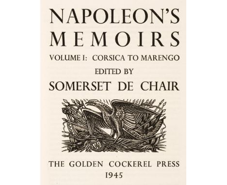
Lot 575
Golden Cockerel Press. Napoleon's Memoirs, edited by Somerset de Chair, 2 volumes, Golden Cockerel Press, 1945, wood-engraved title vignettes by John Buckland-Wright, map endpapers, top edge gilt, original green cloth gilt, a few faded areas, folioQty: (2)NOTESLimited edition 233/500. Presentation inscription to volume I frontispiece verso: "Presented to Dr G.E. Burton, as a token of appreciation and esteem by the Sawbridge A.R.P. First Aid Parties 1939-1946."

Lot 589
Chivers (Cedric). The Sundering Flood, by William Morris, 1st trade edition, Longmans, Green, and Co., 1898, half-title, single-page map, single-page publisher's advertisement leaf at rear, a few light spots, top edge gilt, remainder rough-trimmed, contemporary painted vellucent vellum by Dorothy Carleton Smyth (1880-1933) for Cedric Chivers of Bath, binder's embossed stamp to preliminary blank, artist's monogram DS with dodo motif painted in black to foot of spine, covers very slightly bowed, spine with title lettered in black, gilt flower and seedhead roll to turn-ins, 8voQty: (1)NOTESOf the five women used by Chivers to design, illuminate and colour vellum bindings, Dorothy Smyth was the one 'most frequently employed for this kind of work.' (Tidcombe, Women Bookbinders, 1996, page 86).

Lot 635
Hardy (Thomas). Tess of the D'Urbervilles. A Pure Woman, London: Macmillan and Co., 1926, 41 wood-engravings by Vivien Gribble, folding map of Wessex by Emery Walker, uncut, original vellum-backed boards, dust jacket, 4toQty: (1)NOTESPurdy 77. Limited edition, one of 325 large paper copies, signed by the author. A good copy in the scarce dust jacket.

Lot 660
Nonesuch Press. The Writings of Gilbert White of Selborne, selected and edited with an introduction by H.J. Massingham, 2 volumes, Nonesuch Press, 1938, wood-engraved additional titles and illustrations by Eric Ravilious, folding map, a little minor spotting, top edge gilt, original grey buckram gilt, spines faded, foot of spines a little bumped, 8voQty: (2)NOTESLimited edition 495/850. Provenance: Laurence Frederic Fitzhardinge (1908-1993), Australian author and librarian, his small booklabel.


Lot 824
RUSSIA / NAPOLEONIC WAR DE SEGUR, P. History of the Expedition to Russia… 2 vols. 1825, London, 8vo cont. hf. cf. 3 engrvd. ports. 1 fldng. map (torn, but complete), plus LABAUME, E. A Circumstantial Narrative of the Campaign in Russia… 1815, London, 8vo cont. hf. cf. 2 fldng. maps, plus WILSON, R.T. A Sketchbook of the Military and Political Power of Russia in the Year 1817 1817, London, 8vo cont. fl. cf. recased with new fl. cf. sp. hand cold. fldng. map, plus PORTER, R.K. A Narrative of the Campaign in Russia… 1812 3rd. ed. 1814, London, 8vo cont. hf. cf. lacks map & port. fr. (5)


Lot 658
GORDON (A), THE HISTORY OF PETER THE GREAT, EMPEROR OF RUSSIA, 2 vols, with folding map and three portraits, full tan calf, bookplate for Sir Edward W. Watkin, Aberdeen, Aberdeen, 1755; with two miscellaneous leather bindings (4).Additional InformationThe bindings are heavily rubbed and worn throughout. The edges of the spines are open on both Gordon volumes. One of the spine date tabs is lacking and one of the other tabs is loose. Internally better with general browning and some foxing. The other two volumes are odds from sets, all of the boards are detached and with heavy wear.
Lot 66
A group of militaria items including postcards, an officer's whistle, a hallmarked silver cigarette case with engine turned decoration, a silk map of East Asia, a cloth patch with a skull and crossbones, etc.Additional InformationThe cloth patch with skull and crossbones has tarnishing, stains and possibly mould. It looks as though it may have been pinned at some point with sticker residue to the reverse and there is a large crease down the middle. The silk map is fraying at the edges.
Lot 660
MOORE (T), BRITISH WILD FLOWERS, with 24 hand coloured plates at the back, green cloth, new edition, Reeve & Co, 1867; CORKE (H), WILD FLOWERS AS THEY GROW, five vols, colour plates, green cloths with gilt lettering, Cassell, 1912, with a selection of other botanical books, local interest books and ephemera including an 18th century John Cary map of Cheshire, dated in in 1789 to the lower right (Qty)


![A group of 18th century and later maps comprising 'Gulf of Mexico' [...] by Thomas Kitchin senior, 'Gloucestershire' by Rober](https://cdn.globalauctionplatform.com/7544237a-c5c2-4fd2-8c49-ad3601021d2c/f5403e16-4598-4c4d-bedc-ad3d0109d092/468x382.jpg)
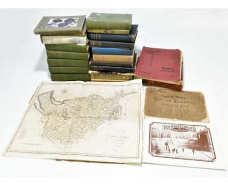
Lot 672
A group of 18th century and later maps comprising 'Gulf of Mexico' [...] by Thomas Kitchin senior, 'Gloucestershire' by Robert Morden, a double sided road map, 'Westmoreland' by Thomas Kitchin and 'A Plan of the Grand Canal from the Trench to the Mersey', also a Replogle World Classic Series 12" globe and four signed etchings by Gertrude Hayes including 'New Buildings Sidney Sussex', 'Sidney Sussex from the Fellows Garden', etc, two frames with crests, all framed and glazed.Additional InformationSome foxing, staining and discolouration, some waviness to paper. Scuffs and general wear to frames. Some stains to globe, as well as further general wear.


Lot 674
JOHN SPEED; a map of Caernarfon, 39.5 x 52.5cm, framed and glazed, and two 19th century rural prints published by Dean & Co, 'Re encounter in a Farmyard' and 'Possession', approx. 23.5 x 30cm, framed (3).Additional InformationWe can confirm that this is an original example, but the piece has an old repair to the right side of the map.
![A 19th century map of Picardia [Picardy], 40.5 x 56cm, framed and glazed.](https://cdn.globalauctionplatform.com/7544237a-c5c2-4fd2-8c49-ad3601021d2c/ba5c2be8-a4df-492b-a44e-ad3d00fd348f/468x382.jpg)


Lot 173
PINKERTON JOHN. An Enquiry into the History of Scotland. 2 vols. Fldg. eng. maps. Laid in manuscript leaves of notes. 1894; also Scotland Delineated or A Geographical Description of Every Shire in Scotland, fldg. eng. map, hand col. in outline, eng. county maps (as called for), rebound qtr. calf, marbled brds., Edinburgh, 1799. (3).


Lot 191
WALLACE JAMES. A Description of the Isles of Orkney. Fldg. eng. map & plate. 16mo. Edinburgh, 1693; bound in calf with An Essay Concerning the Thule of the Ancients, 1693; also Alexander Peterkin, Notes on Orkney & Zetland, vol. 1 (all published), eng. frontis & plate, brown cloth, Edinburgh, 1822. (2).


Lot 26
ANDERSON G. & P. Guide to the Highlands & Islands of Scotland, including Orkney & Zetland. Orig. green cloth in slip case & solander box. 1834; also Scotland Described or A Topographical Description of All the Counties of Scotland, calf, Edinburgh, 1799 & 3 other vols. (5).Condition report:1 - Anderson - Only 2 maps present - Orkney Islands and Zetland Islands, NO MAP OF SCOTLAND.2 - Scotland Described - Yellow staining on fore edge. Some damp staining on pages. NO PLATES OR MAPS.3 - Rebound. Some browning and foxing, splits and tears to folding map. 4 road maps present plus various plates. NO PLATE LIST.4 - Gilpin Vol III - Some foxing and browning. All plates present. 5 - Blacks Guide - Splitting, chipping, wobbly binding, some loose pages, browning, foxing. Various folding maps, plates vignettes etc. but not collated.


Lot 33
MACCULLOCH JOHN. A Description of the Western Islands of Scotland including the Isle of Man. 3 vols. . Calf. 1819; also James Neill (Pubs), Scotland Delineated, hand col. fldg. eng. map, calf, Edinburgh, 1791 & Burton's History of the Kingdom of Scotland with eng. frontis & woodcut ports, small quarto, half green morocco, 1813 & one other. (6). Please note: MACCULLOCH was previously catalogued as as 2 volumes but is now complete with Vol 3 containing plates and maps.Calf bound, has monochrome plates, with hand coloured maps at back (except monochrome Staffa/St. Kilda). 10 maps in total.Maps1. General map of the Western islands2. Sky, Rasay and adjoining islands3. Rum, Egg and Muck4. Mull and the adjoining islands5. Staffa and St Kilda6. The Slate isles etc.7. Isla, Jura, Colonsa and Oransa.8. Arran and Lamlash9. Bute and Gigha10. The Isle Of Man


-
109198 item(s)/page