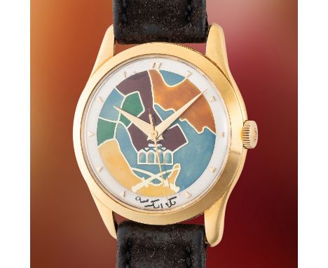

A VERY RARE GENTLEMAN'S SIZE 18K SOLID GOLD OMEGA TRESOR WRIST WATCH DATED 1952, REF. OT 2624 WITH CLOISONNE ENAMEL DIAL DEPICTING A MAP OF SAUDI & THE MECCA, ACCOMPANIED BY AN OMEGA ARCHIVE EXTRACT SHOWING DELIVERY TO SWITZERLANDMovement: 17J, manual wind, cal. 283, signed Omega, numbered 12,4xx,xxx.Case: Diameter approx. 36mm, snap back case, signed Omega Watch Co., numbered 11,0xx,xxx, 18k hallmarks, Omega crown.Strap: Leather strap with Omega gold capped pin buckle. CONDITION REPORTDial: Dial in good condition, showing some signs of age.Movement: Running & functioning at present, timekeeping and accuracy cannot be guaranteed.Case: In very good condition, with some scratches due to general use.Strap/Bracelet: In fair condition.* The dial shows signs of age however it is not possible for us to determine when the dial was made. The archive extract does not reference what dial the watch has.
We found 109198 price guide item(s) matching your search
There are 109198 lots that match your search criteria. Subscribe now to get instant access to the full price guide service.
Click here to subscribe- List
- Grid
-
109198 item(s)/page


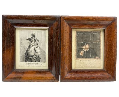
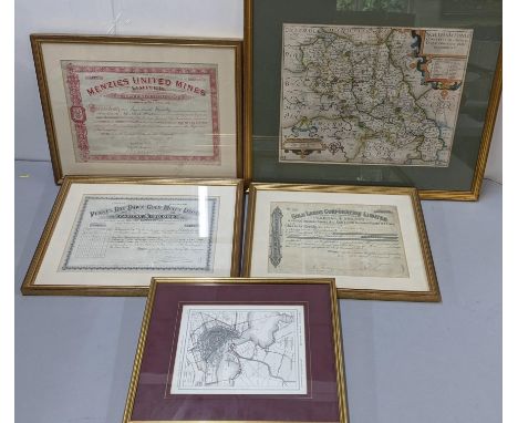
After Francis Nicholson (British 1753-1844): 'Pont Aberglaslyn - North Wales', lithograph pub. Charles Joseph Hullmandel (1789-1850) 28cm x 38cm; 'Christopher Wright' and 'William Sommers', matched pair 19th century engravings 11cm x 16cm in period rosewood frames; After Johannes (Joan) Blaeu (Dutch 1596-1673): 'Lancastria Palatinus' - Lancashire, 20th century reproduction map 40cm x 51cm (4)

THREE DYLAN THOMAS UK 1ST EDITIONS PUBLISHED BY J M DENT & SONS comprising (1) ‘Portrait of the Artist as a Young Dog’, 1940, with d.j (2) ‘The Doctor and the Devils’, 1953, with d.j (3) ‘The Map of Love’, 1939Provenance: from the library of actor David Ponting (1936-2018) who portrayed the poet in 'Dylan Thomas: The Man and The Myth'

FRANCIS GROSE 'The Antiquities of England and Wales', New Edition, 1797, printed for Hooper & Wigstead, Volume VII of an eight volume set of Francis Grose's topographical account of the antiquities of England and Wales, with chapters on Anglesea, Brecknockshire, Caermarthenshire, Caernarvonshire, Cardiganshire, Denbighshire, Flintshire, Glamorganshire, Merionethshire, Montgomeryshire, Pembrokeshire, and Radnorshire, with a large fold-out index map, frontispiece, engraved title page, seventy copper plates, and numerous maps in text, later quality three-quarter polished leather binding, spine with ribs and gilded title and decorationsProvenance: private collection Monmouthshire, title page with stamp for Benjamin F Feinberg Library, State University College, Plattsburgh, New York, withdraw/discard stamps thereafterComments: fine copy, quality binding, pages very good overall

GROUP OF ANTIQUARIAN BOOKS ON WELSH TOPOGRAPHY comprising (1) two volumes GIRALDUS DE BARRI 'Itinerary of Archbishop Baldwin through Wales' 'Translated into English, and Illustrated with Views, Annotations and a Life of Giraldus, by Sir Richard Colt Hoare, for William Miller, London, 1806', both volumes with front boards loose, for restoration or rebinding (2) SAMUEL LEWIS 'A Topographical Dictionary of Wales' 'Comprising the Several Counties, Cities, Boroughs, Corporate and Market Towns, Parishes, Chapelries, and Townships with Historical and Statistical Descriptions, illustrated by Maps of the Different Counties and A Map of Wales, shewing The Principal Towns, Roads, Railways, Navigable Rivers, and Canals for S Lewis & Co, London 1833', binding is loose, for rebinding or restoration, (3) THEOPHILUS JONES Volume 1 & 2 'A History of the County of Brecknock' 'Containing the Chorography, General History, Religion, Laws, Customs, Manners, Language, and System of Agriculture used in that County', London 1805, three-quarter leather bound, marble boards (4) RICHARD FENTON 'A Historical Tour through Pembrokeshire', for Longman, Hurst, Rees & Orme, London, 1810, quarter calf leather bound, gilt title to blue panel upon ribbed spine (6 x volumes total in this lot)Provenance: private collection Monmouthshire


![Speed (John), The Province of Ulster, Thomas Bassett & Richard Chiswell [1676], hand coloured engraved map, inset view of](https://cdn.globalauctionplatform.com/f47dadaf-0544-4966-8660-b0b300d600f8/41edb22e-ed1a-4d2d-a2ea-b0b60054d280/468x382.jpg)


Porcacchi, T. L'isole piu famose del mondo. Venedig, Galignani, 1590. 11 Bll., 201 S. Mit Kupfertitel mit breiter Bordüre, Holzschnitt-Druckermarke am Schluss (datiert 1575) u. 47 kleinen Kupferkarten von G. Porro im Text. 4°. Flex. Pgt. d. Zt. (etw. fleckig, Schließbänder fehlen). Vgl. Phillips 167 (Ausgabe 1576) u. Shirley 127/128 (zur Welt- und Seekarte).- Dritte Ausgabe von Porcacchis Insularium, gegenüber der Erstausgabe von 1572 um 17 Karten sowie textlich nahezu auf den doppelten Umfang erweitert.- Porcacchis Werk steht am Ende einer lang dauernden, nautisch geprägten italienischen Tradition, die Welt in Inseln darzustellen, zugleich ist es das erste Inselbuch mit gestochenen Karten.- 'Pages 157-184 treat of the American islands, embracing a plan of Temistitan (Mexico), a general map of North-America, maps of Hispaniola, Cuba, Jamaica, S. Lorenzo, S. Giovanni; and, besides, pp. 193-201 a general map and a maritime chart of the world with description' (Muller). Außerdem mit Karten von Island, Hebriden, Gotland, Irland, Britannien, Holland, Malta, Rhodos und verschiedenen Inseln der Ägäis etc. sowie Ansichten von Venedig und Konstantinopel.- Die äußerst fein radierten und durch die Punktschraffur des Wassers und die stärkere Tönung der Küstenlinien plastisch wirkenden Karten in guten Abdrucken.- Format der Karten jeweils ca. 11 x 15 cm.- Titel mit rasiertem Stempel.- Nur vereinzelt gering feuchtrandig.

City of Bath, A New and Accurate Plan of the, in the present Year 1803. Kupferstichplan von Hancock nach Chantry bei Savage u. Meyler. London, 1803. In 16 Segmenten auf Leinwand aufgezogen. 47 x 54 cm. Gefaltet in marmor. Pp.-Schuber d. Zt. mit mont. Deckeltitel (schwach berieben). 'A Map of five miles round the City of Bath' (aus dem Druckvermerk).- Mit Titelkartusche, Meilenzeiger, Windrose und umfangreicher Legende.- Exemplar aus der Fürstlich-Starhemberg'schen Familienbibliothek Schloss Eferding (Oberösterreich) mit entsprechendem roten Stempel und Inventarnummer verso.


![Antique Map 'Scotia Regnum'[Frame 63x56cm]](https://cdn.globalauctionplatform.com/70fcd7fb-a797-4b74-aba4-b0b600a8fc48/554038d6-97cd-476f-a221-b0b800bf6763/468x382.jpg)


Set of WWII Medals. (Recipient Unknown), The 1939-45 Star, The Italy Star, The Defence Medal, The War Medal1939-45. Kangol Wear maroon Beret Dated 1945 with original RAMC British Airborne cap badge, associated photograph of Italy and a map of Ravena area in Italy. And an original pair of WW2 1943 dated British Airborne and SOE knee pads


![Japan, collection of woodblock prints [map]](https://cdn.globalauctionplatform.com/2e68002b-789a-4a0d-aaa7-b0a400c62562/a0ed741e-b074-46e6-8b42-b0a500ede88c/468x382.jpg)


SCHOBERL, Frederick, Picturesque Tour from Geneva to Milan, R Ackermann, 1820, large 8vo, with a plan and 36 hand coloured plates. Contemporary calf gilt, all edges gilt. With R Ackermann (publisher) Pictureque Tour Through the Oberland in the Canton of Berne in Switzerland, 1823. With 17 hand coloured plated and a map. In a matching binding (2)Condition:All plates are present in both vols. Plates are very clean and there is very little off-setting.

HARPER, Charles G, The Oxford, Gloucester and Milford Haven Road. 2 vols, 1st edition 1905. With The Manchester and Glasgow Road, 2 vols 1st edition 1905. With BRADLEY, AG, The Rivers & Streams of England. Painted by Sutton Palmer. 1st edition 1909. With 75 colour plates and a map. A volume in the A & C Black 20 shilling series. Pictorial cloth. With other pictorial books (box)


The Churchill Centenary Trust 24 Sterling silver proof medals within capsules and album by John Pinches, limited edition with certificate of authenticity, together withThe Silver Jubilee commemorative stamp edition - a Sterling silver proof Jubilee stamp in fitted case and F.D.C 1977 by Danbury mint, andThe Michaelangelo 500th anniversary medallic F.D.C within folder, andA replica of the Drake silver medal map by Michael Mercator 1589 within fitted case


EAST RIDING OF YORKSHIRE. 3 maps.Eboracensis, Saxton & Hole c 1607. 200 mm by 250 mm. Hand coloured, framed and glazed.BLAEU, Willem & Jan, Ducatus Eboracensis pars Orientalis, The East Riding of Yorkshire. Amsterdam, 1663 or later. 385 mm by 510 mm. Hand colouring to coats of arms. General browning.MORDEN, Robert, map of the East Riding of Yorkshire, c 1695. 360 mm by 420 mm. Hand-coloured, framed and glazed (3)


![Hampshire. Speed (John), Hantshire described and devided, Thomas Bassett & Richard Chiswell, [1676], hand coloured engrav](https://cdn.globalauctionplatform.com/b9199598-926c-41b8-aeda-b0a600f4e350/a2220a71-5efb-4462-bc5f-b0af00bfffd7/468x382.jpg)

Leicestershire. Speed (John), Leicester both Countye and Citie described, The Honorable Famylies that have held the titles of Earls thereof, with other accidents therein observed, John Sudbury & George Humble [1627], hand-coloured engraved map, inset town of Leicester, central fold partially strengthened on verso, occasional repaired marginal closed tears,380 x 510 mm, English text on versoQTY: (1)

Leicestershire. Speed (John), Leicester both Countye and Citie Described, The Honorable Famylies that have had the titles of Earls thereof. With other accidents therein observed, John Sudbury & George Humble [1627], uncoloured engraved map, inset city plan of Leicester, central fold strengthened and repaired on verso, 380 x 505 mm, English text on verso, together with another 24 county maps, including examples by or after Fullarton, Archer, Hall, Smith, Cary, Seller/Grose, Hermannides, Taylor/Blome. Moll, Kitchin, Ellis, Lewis and J & C Walker, some duplicates, various sizes and conditionQTY: (25)
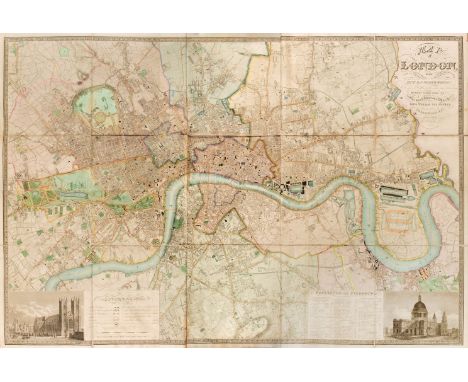
London. Greenwood (C & J), Map of London from an actual survey made in the years 1824, 1825 & 1826..., Extended and Comprising the various improvements to 1830, Greenwood & Co, 31st August 1830, large scale map engraved by Josiah Neele with contemporary wash colouring and some later enhancement, sectionalised and laid on linen, calligraphic title, inset views of St Pauls and Westminster, reference to the parishes and table of explanation, very slight spotting, 1260 x 1855 mm, later manuscript ownership signature to verso, contemporary sheep with gilt title to upper siding, heavily worn and frayed, spine partially detached, binding size 460 x 395 mm QTY: (1)NOTE:Howgego. Printed Maps of London, number 309, state 2.
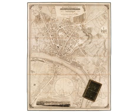
Newcastle Upon Tyne. Oliver (Thomas), Plan of the Town & County of Newcastle Upon Tyne and the Borough of Gateshead with their respective Suburbs..., 1830, uncoloured city map of Newcastle upon Tyne engraved by W.H Lizars, sectionalised and laid on linen, inset vignette of Newcastle upon Tyne from the south, inset circular map of the plan of the Town Moor, compass rose, calligraphic title and dedication, slight staining and offsetting, unobtrusive near contemporary manuscript hatching to the printed surface, edged in green silk, later manuscript ownership signature to verso, contained within a contemporary gilt morocco book box, worn, rubbed and frayed, lacking the containing strips at the head and foot of the boxQTY: (1)
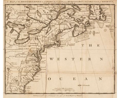
North America. A Map of the British Empire in America, from the Head of Hudson Bay to the Southern Bounds of Georgia, with the intervention of Canada, Owen's Magazine of Magazines, Novr. 1750, rare uncoloured engraved map, old folds, long closed split along one fold, one marginal closed tear affecting the printed image, slight staining, 260 x 305 mm, together with Plan of ye Town of Quebec, Owen's Magazine of Magazines, Novr. 1750, uncoloured engraved map, key plate to the right-hand margin, old folds, trimmed with very slight loss to the text on the right-hand margin, 200 x 255 mm, with A Map of the Isthmus of Darien whereon is traced the Adventurers Expedition, Owen's Magazine of Magazines [1750], uncoloured engraved map, trimmed with very slight loss to the text of the title, 125 x 180 mm, plus Kitchin (Thomas). A Map of Royal or Cape Breton I. from the best Authorities, circa 1780, uncoloured engraved map, slight dust soiling, 170 x 110 mm, and a small unattributed 18th-century map of a plan of Maastricht, 170 x 110 mmQTY: (5)NOTE:The first described map. David C. Jolly, Maps of America in Periodicals before 1800 number 38 (but described as lacking the imprint at the base of the map). Not recorded in R. V. Tooley's The Mapping of America.
![[Dumez (A. & Chaulaire P.G.)]. Précis élémentaire et méthodique de la nouvelle Géographie de la France..., pour servir de](https://cdn.globalauctionplatform.com/b9199598-926c-41b8-aeda-b0a600f4e350/0f7ac59b-689f-4381-a046-b0af00bfcd80/468x382.jpg)
[Dumez (A. & Chaulaire P.G.)]. Précis élémentaire et méthodique de la nouvelle Géographie de la France..., pour servir de Développement à l'Atlas national portatif de la France... par les Auteurs de l'Atlas national de France. Paris: Au Bureau de l'Atlas National, 1791, printed title and introduction, index and tables, contemporary manuscript contents list, additional decorative half-title of an outline map of France with a floriate border and 89 engraved maps of France and its departments, all with contemporary outline colouring, and an uncoloured map of the world on Mercator's projection, a few folding, slight dust soiling, contemporary half calf gilt with contrasting morocco label to the spine, some wear, oblong 4to QTY: (1)
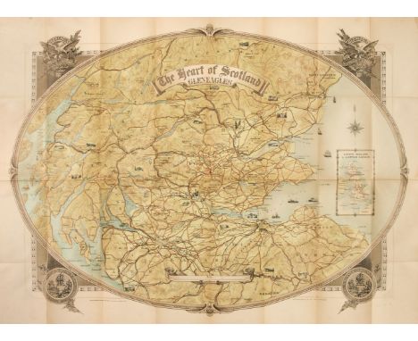
Scotland. Johnston (W. & A.K. printers), The Heart of Scotland, Gleneagles, constructed and printed by W. & A. K. Johnston Ltd. Edinburgh, published McCorquodale & Co. Ltd. Glasgow, circa 1930, large colour lithographic map, inset map of the British Isles showing the extent of the London, Midland & Scottish Railway, old folds, very slight staining, laid on contemporary linen, 800 x 1070 mm, marbled endpapers, bound in publisher's decorative colour printed boardsQTY: (1)
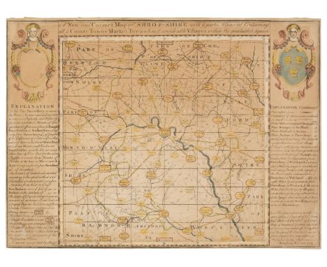
Shropshire. Porter (Benjamin), A New and Correct Map of Shrop-Shire with ye parts Adjacent Containing all ye County Towns, Market Towns & most Considerable Villages within the Graduated Square, 1734, hand-coloured engraved reticulated map with an explanation in both vertical margins, toned overall, trimmed to the plate mark, 310 x 425 mmQTY: (1)NOTE:Rare. No institutional copies were found. Benjamin Porter is not recorded by Worms and Baynton Williams or by Tooley.

-
109198 item(s)/page