We found 109182 price guide item(s) matching your search
There are 109182 lots that match your search criteria. Subscribe now to get instant access to the full price guide service.
Click here to subscribe- List
- Grid
-
109182 item(s)/page


Lot 427
MODERN FRAMED AND GLAZED COLOUR PRINT 'THE NEW MAP OF THE WORLD' published 12th May 1794, 23 1/2" x 35 1/2" (59.5 x 90cm) MODERN FRAMED AND GLAZED HAMMOND MAP OF THE GULF, CARIBBEAN AND ATLANTIC COAST AREA, also a framed and glazed 'The Malt Map' (Scotland's Most Famous Single Malt Whiskys) (3)


![Richard Blome (1660-1705) British. "A General Mapp [sic] of South Wales", Map, 14" x 18.25".](https://cdn.globalauctionplatform.com/44ec7e85-1fdb-4617-9d4c-a8a300a417a6/9d5f0067-e24b-4701-facb-9ab333921670/468x382.jpg)


Lot 137
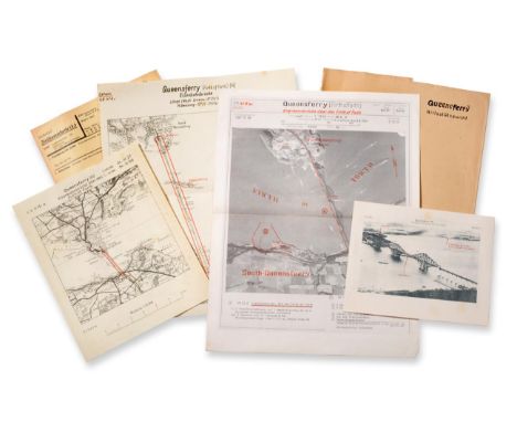
Nine Annotated Folders, Arial Photographs and Maps of Potential German Third Reich Bombing Targets in the Vicinity of the River Forth, all marked ''Secret'' (Geheim) and variously dated March - November 1939, comprising: Queensferry (Forth Bridge and Oil Storage Facilities) - Dossier, two aerial photographs and two maps; Tranent (Macmerry) - Dossier and two maps of the airfield; Donibristle - Dossier, aerial photograph and map of the airfield Edinburgh (Granton Harbour Basin) - Dossier, two aerial photographs and two maps; Turnhouse - Dossier, two aerial photographs and two maps of the airfield; Edinburgh (Leith Gasworks) - Dossier, two aerial photographs and two maps Grangemouth (Fuel Storage) - Dossier, one aerial photograph and one map; Grangemouth (Large Fuel Depot) - Dossier, aerial photograph and two maps; Grangemouth (N) (Fuel Storage) - Dossier, two aerial photographs, one map and three pages of typewritten notes Footnote: These items are accompanied by an Edinburgh Evening News article, dated January 29th 1972, outlining the history of their ''liberation'' from the Luftwaffe Headquarters in Munster by the then 26-year-old R.A.F. Flight Sergeant William Rennie

Lot 294
An Abalam Yam Mask, Papua New Guinea, constructed of woven wicker, 61cm by 29cm; a Papua New Guinea Tapas Cloth, of rectangular form, painted with animals and palm trees in black on a chocolate brown field; 85cm by 108cm; Papua New Guinea Road System 1977, a large colour printed map, 126cm by 182cm (3)


Lot 928
An unusual 17th century black and white anatomical engraving of human legs and feet, inscribed Giacomo Franco, Forma Con Privilegio, 25 x 18 cm sheet size approx, unframed, together with an unframed 18th century black and white road map by John Ogilby, showing the continuation of the road from London to Aberystwyth, 38 x 47 cm approx sheet size

Lot 953
A quantity of pictures and prints including mixed media study of a cockerel in illuminated style surround, a painting on glass of a peacock, an 18th century map of Lincolnshire after Saxton, a set of six late 19th century coloured prints of hunting and interior scenes (in two frames), a large oil painting on canvas, a large oil painting on canvas of fighting cocks in heavy gilt frames, etc

Lot 193A
Hand tinted map of Lancaster by John Speede circa 16509cm high x 12cm wide, further double sided road map from York to Lancaster circa 1700, 19x28cm, further hand tinted map of Lancashire early 18th Century, 14x17.5cm and a facsimile coloured map of Lancashire originally done in 1577, 39x48cm all framed and glazed (4)


Lot 518
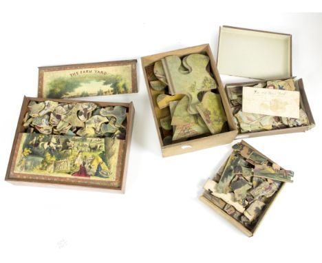
A quantity of Victorian jigsaw puzzles including a Gall & Inglis dissected map of Europe in a W H Cremer box titled 'Cremers Popular Dissections; The Progress of Farming, published by F Green, Holborn with folding plan; Silk and its Manufacture, published Philip, Son & Nephew, London, with folding plan; The Horse and its Uses with folding plan and three others Condition Report: Map - three pieces missing. Norway piece looks broken in half. Some discoloration, some pieces slightly warped, box missing one end, lid a little warped, dirty. Progress of Farming - plan discoloured, some splitting to seams where folded, small tear, a number of small losses, mainly to the 'peg' part of pieces. Some small surface losses particularly behind figure Threshing. Some discolouration, no box. Silk - A few 'peg' parts missing, slight peeling to paper and slight discolouration. Plan folded, torn and repaired, box cover only (discoloured). One female figure snapped in two. Horse - 1 peg part broken, slight losses to paper. Worm damage visible front and back. Paper plan folded and heavily repaired with sellotape. Box cover only, warped, repaired with sellotape. Robin Hood- Missing perhaps three or four pieces, small losses to joins. Box incomplete. Cover broken in two. Unnamed depicting House and Garden - three 'pegs' broken but with item. Discoloured. General scuffs.The Farm Yard, Harvest Evening - A number of 'pegs' broken, some with lot. Slight lifting here and there to paper, scattered discolouration, box complete but lid broken in two.

Lot 72
A presentation box of Ando Hiroshige facsimile images; each one taken from an original in the Tokaido Road series; together with a related, Japanese language, booklet and map, giving notes on each of the Tokaido stations from Nihonbashi in Edo to the Great Bridge at Sanjo in Kyoto. Each image oban yoko-e (lot)The box itself damaged and soiled, but the images themselves, although apparently unopened, may vary in condition slightly.


Lot 222
Memoires complets et authentiques de Charles-Maurice de Talleyrand Prince de Benevent, Paris, Jean de Bonnot, 1967 (five volumes), green binding with gilt decoration of foliage and lions; Lettres de Talleyrand a Napoleon d'apres les orginaux conserves aux archives des Affaires etrangeres, Paris, Jean de Bonnot, 1967, green binding with gilt decoration of foliage and lions; Lettres de Napoleon a Josephine et de Josephine a Napoleon premiere edition integrale etablie par Jacques Haumont, Jean de Bonnot, Paris, 1968, green Morocco with gilt decoration of bees; and Relation Complete du Naufrace de la Fregate La Medue, published by Jean De Bonnot, Paris, 1968, blue binding with gilt decoration of map work

Lot 241
A collection of books relating to Mauritius (Ile-de- France), in all about sixty books including: Charles Giblot Ducray - Histoire de la Ville de Curepipe; S. B. de Burgh Edwardes - L'Histoire de L'ile Maurice; De Maurice A Paris via Natal Lettres de Henri Laval, Port Louis, 1920 (quarter calf binding); Memoires de L'Academie Malgache, Pitot de la Beaujardiere, 1934, 1936 (three), 1937, 1939 (two); Bulletin de L'Academie Malgache, 1934, 1935, 1936, 1937; Mauritius Archives Publications nos 4, 9, 11 and 12; Decisions of The Supreme Court of Mauritius During the Year 1891 index ed. Arthur Thibaul, etc; together with four engravings - After S Milbert and Gossard - Ile-de-France vue des Bambous de la Riviere des Amans, (22.5cm x 30cm); after H Winkles and J. Rapkin - Islands in the Indian Ocean, tinted engraved map published by John Tallis and Company (26cm x 35cm); La Rue Des Forges au Port-Louis (12.5cm x 17cm) and La Grand Riviere (12.5cm x 16.5cm), each framed and glazed [see also lots 172 and 180]


-
109182 item(s)/page