We found 109198 price guide item(s) matching your search

Refine your search

Year

Filter by Price Range
  • List
  • Grid
  • 109198 item(s)
    /page

Lot 58

Rarely offered volumes from Hetzel's French edition Aux Initiales Dorees (without J.V.) from the Voyages Extraordinaires by writer Jules Verne. It includes the novel Nord Contre Sud (Texar's Revenge/North Against South) in two volumes with 85 illustrations by Benett and one map. Includes stamps of owner: Eric Weissenberg. Collection Hetzel, Bibliotheque d'Education et de Recreation, published by Pierre Jules Hetzel et Cie, Paris. Artist: Jules Verne (French 1828-1905)Issued: 1887Dimensions: Each: 7.25"W x 11"H x 0.80"DManufacturer: HetzelCountry of Origin: FranceProvenance: Collection of Marie-Claude Lalique Condition Very Good. Color loss on spines. Vol 1: minor color loss on cover. Vol. 2: minor foxing.

Lot 59

Lot of two volumes from Hetzel's French edition Aux Initiales Argentees, Voyages Extraordinaires by writer Jules Verne. The first book includes the novel Nord contre Sud (North Against South) with 85 illustrations by Leon Benett and one map. The second book includes Keraban-Le-Tetu (Keraban the Inflexible) with illustrations by Bennet. It includes the Ex-Libris: Gaston Janus. Collection Hetzel, Bibliotheque d'Education et de Recreation, published by Pierre Jules Hetzel et Cie, Paris. Artist: Jules Verne (French 1828-1905)Issued: c. 1894Dimensions: Each: 7.50"W x 10.75"H x 0.80"DManufacturer: HetzelCountry of Origin: FranceProvenance: Collection of Marie-Claude Lalique Condition North contre Sud: vibrant cover with slight discoloration on spine. Some foxing and soiling. Keraban-Le-Tetu: Some foxing and tearing on the spine, soiling on back cover.

Lot 6

Excellent volume from Hetzel's French edition Au Portrait Colle Voyages Extraordinaires by writer Jules Verne published between 1892-1895. It includes the novel Famille-Sans-Nom (Family Without a Name) with illustrations by G. Tiret-Bognet and a folding map in color. Includes the new catalogue for 1892-1893. Collection Hetzel, Bibliotheque d'Education et de Recreation, published by Pierre Jules Hetzel et Cie, Paris. Artist: Jules Verne (French 1828-1905)Issued: 1892Dimensions: 7.25"W x 11"H x 1.40"DManufacturer: HetzelCountry of Origin: FranceProvenance: Collection of Marie-Claude Lalique Condition Very good.

Lot 7

Outstanding volume from Hetzel's French edition Au Portrait Colle, Voyages Extraordinaires by writer Jules Verne published between 1892-1895. Polychrome second cover Lenegre type e. It includes the novel Famille-Sans-Nom (Family Without a Name) with 82 illustrations by G. Tiret-Bognet and a map in color. Includes the new catalogue for 1893-1894. Collection Hetzel, Bibliotheque d'Education et de Recreation, published by Pierre Jules Hetzel et Cie, Paris. Artist: Jules Verne (French 1828-1905)Issued: 1894Dimensions: 7.25"W x 11"H x 1.40"DManufacturer: HetzelCountry of Origin: FranceProvenance: Collection of Marie-Claude Lalique Condition Very good.

Lot 9

Beautiful volume from Hetzel's French edition Au Portrait Colle, Voyages Extraordinaires by writer Jules Verne published between 1892-1895. It includes the novel Keraban Le-Tetu (Keraban the Inflexible) with 101 illustrations by Leon Bennet and one map. Includes the new catalogue for 1892-1893. Collection Hetzel, Bibliotheque d'Education et de Recreation, published by Pierre Jules Hetzel et Cie, Paris. Artist: Jules Verne (French 1828-1905)Issued: 1892Dimensions: 7.25"W x 11"H x 1.40"DManufacturer: HetzelCountry of Origin: FranceProvenance: Collection of Marie-Claude Lalique Condition Very good. Minor color loss on spine and front cover. Vibrant gilding.

Lot 1

AMSTERDAMBORMEESTER (JOCHEM) Novissima Amstelodami Tabula, hand-coloured double-page engraved plan of Amsterdam, with inset panoramic view below of numerous ships at sea with the city in the distance, flanked by allegorical scenes, map keys in top corners, slight toning, a little restoration and strengthening on reverse, sheet 500 x 616mm, image 475 x 587mm, Amsterdam, [c.1685]Footnotes:Bormeester's very rare plan of Amsterdam during the Golden Age, issued some 20 years before the better known amended Covens and Mortier version.This lot is subject to the following lot symbols: •• Zero rated for VAT, no VAT will be added to the Hammer Price or the Buyer's Premium.For further information on this lot please visit Bonhams.com

Lot 197

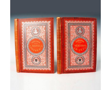
An exceptional late 18th century French gilt and patinated bronze pendule à cercle tournant timepiece dated 1780Lepaute, ParisThe case surmounted by a 5 inch spherical gilt globe engraved with a map of the world and displaying the time at the equator via twin horizontal rotating bands, the uppermost with 12 white enamel five-minute Arabic cartouche numerals, over 24 larger Roman cartouche numerals (12 with black numerals on a white ground to denote daytime, 12 with white numerals on a black ground to denote night-time), the globe draped in a midnight blue metal cloth studded with brass stars, a flying cherub below holding a flaming torch to indicate the time; all supported on a crisply cast Corinthian reeded column on an octagonal base. The rectangular movement set within the column and accessed via a door to the font, with pin-wheel escapement driving a vertical arbor via a contrate wheel up into the globe, the striking via an outside countwheel strike on a bell. Signed along the lower edge LE PAUTE. H.ger DU ROI APARIS 1780. Together with a winding key and Insurance Certificate from J. Kugel, Antiquaires, Paris dated 1996. 16 wide x 16 deep x 42 high (6in wide x 6in deep x 16 1/2in high)Footnotes:The Lepaute family is rightly regarded as one of the foremost horological dynasties working in 18th century France. Perhaps the best known member is Jean-André Lepaute (also spelled Le Paute), born in 1720 in Thonne-la-Long, a small town in north-eastern France. Lepaute was one of nine children, who were supported by their father, a farrier. Lepaute served his horological apprenticeship in the nearby town of Carignan, before moving to Paris in 1740. He immediately established a workshop, which was evidently prosperous as he encouraged one of his younger brothers, Jean-Baptiste, to join him in 1747, around which time the workshop was well known for making turret clocks. Two years Jean-Andre married Nicole-Reine Étable de la Brière, who was a celebrated astronomer and savant. In 1759, she helped to predict the path of Halley's Comet and was described as 'a human calculator'. She was also responsible for any horological calculations needed in the workshop (e.g. pendulum oscillation, etc.). Two years after his marriage, Lepaute invented a clock which worked with only one wheel; he presented this to Louis XV, receiving the commendation of Horologist to the King. He also developed modifications to the double virgule escapement in 1753 although this caused controversy when another horologist, Pierre Augustin Caron, insisted he was the original maker. The Academie Royale des Sciences initially agreed that Caron was the original inventor, though this decision was later reversed and both were deemed to have created the escapement independently of one another. In 1755, the elder Lepaute published his Traité d'Horlogerie, with Nicole-Reine helping with the calculations. He was named maître in 1759, with Jean-Baptiste becoming maître in 1776, and he became increasingly involved with the Galeries du Louvre, where both he and Nicole-Reine had lived since 1756. Around this time, he appears to have left Jean-Baptiste to manage the workshop. Throughout this period Nicole-Reine continued to publish astronomical papers and contribute chapters to astronomical books, including a widely circulated table in 1764 for the calculation of the solar eclipse occurring on 1 April. In 1774, Jean-Andre Lepaute formally retired from the workshop, and both he and Nicole-Reine moved to St. Cloud. He died in 1788, a year after his wife. Jean-Baptiste retired in 1789, leaving the workshop to his two nephews, both of whom were trained horologists. Jean Baptiste died in 1802, though the Lepaute workshop carried on under first the two nephews, and then their descendants, until 1952. The Lepautes supplied clocks to some of the most prestigious sittes, including the Luxembourg Palace in Paris, the Palais Royal and the Military Academy in St. Hubert, among others. In addition to turret clocks, the workshop produced a multitude of mantel clocks, usually with a figural bronze case, often featuring characters from Ancient Greek or Roman mythology. A version of the globe clock was offered for sale from their workshop in 1766 for 2,500 livres; one of the costliest mantel clocks they produced at that time. Literature A Chapiro, La Montre Française. Paris: Éditions de l'Amateur, 1991.Tardy, Dictionnaire des Horlogers Français, 127th edition, Aubenas: Lienhart et Cie, 1972.P. Garcelon, Nicole-Reine Lepaute (1723-1788), 2022. Available at: https://pg-astro.fr/grands-astronomes/le-grand-siecle/nicole-reine-lepaute.htmlUniversity of St. Andrews School of Mathematics and Statistics, Nicole-Reine Etable de Labrière Lepaute, 2008. Available at: https://mathshistory.st-andrews.ac.uk/Biographies/Lepaute/Comparable literature J-D. Augarde, Les Ouvriers du Temps, Antiquorum and the Trustees of the Wallace Collection, p.26, fig.12. A similar case but with patinated column was sold Christies, New York, Dalva Brothers: Parisian Taste in New York, 22 October 2020, lot 171.This lot is subject to the following lot symbols: ** VAT on imported items at a preferential rate of 5% on Hammer Price and the prevailing rate on Buyer's Premium.For further information on this lot please visit Bonhams.com

Lot 2

WORLD MAPVAN DER AA (PIETER) Nova orbis terraquei tabula accuratissime delineata, hand-coloured double-page twin hemisphere engraved map, with allegorical vignettes of the four continents and the creation, cartouche with title in French ('Mappe Monde ou description generale du globe terrestre et aquatique. Selon les nouvelles observations de Messrs. De l'Academie des Sciences etc.'), slight toning, some restoration visible on verso (a few small holes filled, one or two strengthening strips), sheet 550 x 745mm, image 495 x 655mm, Leiden, P. van der Aa, [c.1713]Footnotes:Decorative world map showing California as an island, issued in Pieter van der Aa's Le Nouveau Theatre du Monde [Koeman, Atlantes Aa 6].This lot is subject to the following lot symbols: •• Zero rated for VAT, no VAT will be added to the Hammer Price or the Buyer's Premium.For further information on this lot please visit Bonhams.com

Lot 195

A collection of WWI & WWII service booklets and documents, including a Gallipoli/ Krithia linen backed map, postcards and related ephemera

Lot 229

Operation Sea Lion,1940. A copy of 'Militargeographische Angalen uber England Sudkuste' (Military Geographical Information about England, South Coast) text and picture booklet with map attachment , complied 15th August 1940, published by Army General Staff Army Department of General Maps and Surveying, Berlin 1940, green paper covers, with slip in insert notice.

Lot 561

A Military issue Field Telephone, together with a Board Map G.S No.2 MkI by Holbro, with Sgt's name in ink (SGT ANDREWS No.2 Platoon PO/X 105650), a helmet, a gas mask and more (parcel)

Lot 621

A German Luftwaffe 1940 Target Map of the Midlands, together with a British RAF Edition (War) map of the Midlands, and a Luftwaffe cloth badge (3) Possibly Reproduction, please form own opinion before bidding

Lot 217

King & Country - Imperial China Series, comprising: Set IC039 - General and Map, Set IC051 - Chinese Fort Main Gate, Set IC052 - Left Tower, Set IC053 Right Tower & Set IC066 - Marching Flagbearer. Mint overall, contained in near Mint set boxes. [5]

Lot 347

An Afghan Belouch ‘War’ rug, circa 1980, relating to the Soviet War in Afghanistan and depicting an annotated map of Afghanistan depicting architectural, zoomorphic motifs and machinery of war, 132cm x 79cm, together with another Afghan rug with a madder field depicting an outline map of Afghanistan alongside traditional flowerhead and S motifs interspersed with anti-aircraft vehicles, hand-grenades and Kalachnikov rifles and other weapons, 72cm x 63cm

Lot 349

An Afghan Belouch ‘War’ rug, circa 1980, relating to the Soviet War in Afghanistan and with an ivory field of an annotated map of Afghanistan depicting machinery of war, helicopters, tanks and anti-aircraft vehicles; woven with textual inscriptions76cm x 60cmTogether with a receipt of purchase from Liberty of London

Lot 370

John Speed,Northamptonshire,hand coloured county map,39x51cm,and another similar county map.Qty: 2

Lot 162

A framed map of Warwickshire and Leicestershire after Saxton, together with a brass model cannon on carriage, magazine rack, brass bin

Lot 564

A John Rudkin signed limited edition print of The Yorkshire Dales, hand coloured engraved map of England, watercolour landscape and several other pictures

Lot 8061

A pair of marine chronometers - one an Imhof quartz Swiss with Roman numerals and outer seconds track, other a Millennium year 2000 with world map dial. . 6.5 and 9cm diameter dials respectively

Lot 111

A Framed 19th Century Map of Dorsetshyre by John Speed and Jodocus Hondius Dated 1662 51x38 cms

Lot 439

Mixed collectables to include pens, medals, meerschaum pipe in case, trench art box., Tunbridge Wells map block, whistle, badges etc.

Lot 338

17th century map of Sussex by Robert Morden, c1695. Engraved and hand coloured. Central fold. Framed and glazed. Frame: 63cm x 57cm

Lot 202

WWI officers marching equipment comprising: leather and cloth haversack, 2 map cases, binocular case dated 1915; Sam Browne holster; sword frog and ammunition pouches; pair of anklets and 2 leather pouches. £70-80

Lot 203

A quantity of WWI leather equipment, comprising: officer's haversack, map case, binoculars in 1915 dated case, Sam Browne belt, sword frog and 2 ammunition pouches. H.G gaiters, pouch dated 1918 and other items. GC £70-80

Lot 43

4 Unusual items relating to post war British Occupation Zone: a gilt mounted compact, in its original box of sale; 3 different citgarette cases. Each is emblazoned with an engraved Zone map. GC £40-50

Lot 446

A 20th century Egyptian copper cigar box by Granger, engraved to the top with the map of The Battlefields of Europe during WWII

Lot 580

Four antique engravings, including an old map of British Isles

Lot 893

An oil on canvas of African shanty town - signed DIGZ - together with map of France

Lot 1027

Including map from Leoverdia, 1649, by J. Blaeu with old coloring, 52 x 41 cm. This lot will not be shipped by the auction house.

Lot 196

Artist late 19th Century, map in red velvet with painted wooden cover, in different colours, portrait of a young man reading a book, 40 x 30 cm

Lot 155

Map. "Carte des Gouvernements de Flandre Francoise, d'Artois, de Picardie". Framed and glazed. H.46 W.58 cm.

Lot 1103

Framed drawn map, bottom left description, The Baronnie van Ysselsteyn With all its waterways, mills, etc. formed in the year 1738 by PJ Adan, and copied by me Adm: Landmeeter, deesen 23 October 1770 DWC Hattinga, 61x134 cm, incl. frame total 85x159 cm (origin of contents of a historic house and noble family from the center of the Netherlands)

Lot 1181

Willem Blaeu (1571-1638)Framed topographical map of the province of Utrecht from 1635, marked at the top right Guiljelmus Blaeu, 39 x 50 cm, incl. frame in total 57 x 70 cm (origin of contents of a historic house and noble family from the center of the Netherlands)

Lot 1243

Dutch topographical map by Isaak Tirion with text: 'New map of Switzerland in Amsterdam', engraving 18th century, 35x39 cm

Lot 3222

Map with, among other things, 20 provincial maps, Jacob van Deventer

Lot 398

Two maps and a print to include Willem Jansz Blaeu (1571-1638), 'Orcadum et Schetlandiae', hand coloured engraved map of the Scottish Islands; a map of the Kingdom of Galicia after an original by Fernando Ojea for Abraham Ortelius; and an etching of the Royal Hospital at Chelseathe 'Orcadum et Schetlandiae' map 38cm x 50cm; The Kingdom of Galicia map 36cm x 41cmQty: 3'Orcadum et Schetlandiae' in generally good condition with some creases where the fold of the page would have been and minor toning. The Kingdom of Galicia map with notable toning throughout, some foxing and some discolouration. The print in generally good condition.

Lot 261

A large collection of paintings, prints and a map etc.

Lot 32

A coloured map of Hertfordshire

Lot 35

Nicholas Sanson, antique map of Africa

Lot 519

After S. Bowers, 19th Century coloured print in gilt frame; and a coloured map of Suffolk after Saxton

Lot 538

An Icon style print; a coloured map of St. Albans; various other prints and frames etc.

Lot 31

Reproduction coloured map of Norfolk

Lot 11

Tombleson's panoramic map, Thames and Medway, framed, width including frame 42cm, height 146cm

Lot 691

John Cary (1754-1835), 18th century hand coloured engraving, map of Cumbria and Westmorland, publ. 1st June 1794, 27 x 21cm

Lot 732

John Speed (1552-1629), Map of Jamaica and Barbados, hand coloured engraving, sold by Thomas Bassett and Richard Chiswell, 39 x 51cm

Lot 771

A.F. Zürner, coloured engraving, Map of Africae in Tabula Geographica Delineatio, published by Petrus Schenk, 40 x 47cm

Lot 594

THREE BOXES AND LOOSE DECORATIVE PICTURES AND PRINTS ETC, to include two dry point etchings depicting trees signed Rausen?, map of Chester by Emanuel Bowen circa 1756, approximate size 59cm x 74cm, 18th century road map of the Bishopric of Lichfield and Coventry, 19th century topographical prints, print reproductions of paintings, dried flower pictures, etc

Lot 1179

Diverse herdenkings munten; w.o. 'Ons Vorstenhuis' in cassette. [2 cas + zkj + map]

Lot 1195

Yajoi Kusama voor Louis Vuitton, zijden sjaal met stippen print en LV logo. Collectie van 2012 In doos. Gecompleteerd met inpakpapier van Kusuma. [1 + map]

Lot 482

Cantium Kent Local History 1974 Spring, Summer, Autumn, Winter, County of Kent Register of Electors 1955 - 1956 (signs of ageing), Canterbury Street Map, collection of local interest receipts Ashford, Dover, Folkestone, Margate, Copy / Facsimile of Ashford Working Men's Club and Institute - Our Club: Its Progress and Work 1922 - 1938, local interest, good condition. Good condition. All autographs come with a Certificate of Authenticity. We combine postage on multiple winning lots and can ship worldwide. UK postage from £5.99, EU from £7.99, Rest of World from £9.99

Lot 917

20th Century, coloured print, An illustrated and historical map of Westmorland, number 162, framed and under glass, measuring 48cm x 66cm overall

Lot 905

After Alfred Wainwright MBE (1907-1991), print, 'A Map of the County of Westmorland', illustrated with landmarks around the county including Striding Edge (Helvellyn), Bridge House at Ambleside, and Helm Crag, framed and under glass, 57cm x 64cm overall

Lot 911

*Lake District Interest - After Alfred Wainwright MBE (1907-1991), reproduction print, 'A Map of the County of Westmorland', illustrated with landmarks in the area including Ullswater, Lowther Castle, and Nine Standards Rigg, framed and under glass, 55cm x 63cm overall

Lot 896

Jepson (20th Century), chalk on board, A portrait of a North American Indian, signed and dated '01 to the lower left, 53cm x 60cm, a watercolour of gorilla heads, a still life painting on canvas, and an unframed map of Westmorland and Cumberland (4)

Lot 508

The Story of The Canadian Pacific Railway by Keith Morris 1931 - 208 page book with 26 full page photographs and fold out Map- Extensively detailing the history and development plus accounts about their long distant trains and connecting ships at that time- Printed on semi-gloss paper in pictorial card covers, size 4.75" x 7.25"

Lot 551

Turkey on Horseback Through Asia Minor by Captain Fred Burnaby 1877 Volume I, 3rd edition; xxxiii, 352, 24. Tipped in photograph of author and fold out map- Volume II, 2nd edition; xx, 399 and fold out map. As called for, giving an extensive and interesting account regarding the authors travels across Turkey and the various people he encountered. In cloth board cover with pictorial front cover, each size 6" x 9"

Lot 748

USA - The Glacier National Park (Montana) 1914 - popular guide to its Geology and Scenery by Marius R. Campbell, 54pp, 12x plates, very large folding coloured map in envelope, printed grey paper wrap, rear detached, stapled, published by the US Geological Survey, Washington 1914

Lot 992

Scottish History Books Chambers Gazetteer of Scotland, to include Chalmers Gazetteer of Scotland 1832 both with front piece map Vols 1 (rebound) and II, Edinburgh Vol 1844 (3), plus The Book of the Trotters Club - Volume one and two, both published and printed for the Club by Gordon Wilson, Edinburgh at the Thistle Press, Edinburgh 1909, the Trotting Club was originally a rambling club but also enjoyed bowling skittles and Saturday nights out with photographs - both in original red boards G; and 1802 Pocket Encyclopaedia or a Dictionary of Arts, Sciences, and Polite Literature - Volume IV. Kendal, Edward Augustus: 3 volumes only volume I, III, V, full leather-bound boards, with some signs of wear to spines (8)

Lot 311

Antique Well Framed Early West Riding of Yorkshire Map

Lot 1372

Vintage brass cigarette case decorated with raised relief map of Australia, 11cm x 8.5cm approx

Loading...Loading...
  • 109198 item(s)
    /page

Recently Viewed Lots