We found 109182 price guide item(s) matching your search
There are 109182 lots that match your search criteria. Subscribe now to get instant access to the full price guide service.
Click here to subscribe- List
- Grid
-
109182 item(s)/page


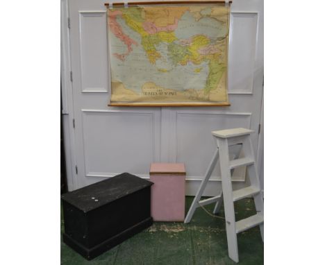
Lot 3505
Automobilia - Ephemera - Wolseley Motors Ltd, Birmingham, Miniature Catalogue of Wolseley Auto Cars, No.715, October 1924; The Motor Specifications and Prices of 1954 Cars; others, 1956, 1958; a motoring map; cigarette cards; Equestrian, Programme of the Tollygunge Club Gymkhana Races Monsoon Meeting, Fourth Day, 16th July 1932 (8)

Lot 3517
A pair of late Victorian printed adverts, for Williams' Perran Foundry Co, Revolving Stamps, Stamps for Crushing Ores and Crushing Mill, illustrated with line engravings, Perranarworthal, Cornwall and London, 25cm x 19cm; a two-fold map of Cornwall, includibng the Scilly Isles, 18cm x 24cm; late 18th/early 19th century Laurie two-fold map, Cumbria, Yorkshire, Westmoreland and Northumberland, hand-coloured engraving, 31cm x 26cm; etc, [5]

Lot 3538
Chalmers (George), Caledonia: or, A Historical and Topographical Account of North Britain from the Most Ancient to the Present Times, with A Dictionary of Places Chronological and Philosophical, eight-volume set, Alexander Gardner, Paisley 1887 - 1902, volume I with six-fold map of the territory, maroon morocco spines and buckram boards, folio; Landscape-Historical Illustrations of Scotland, and the Waverley Novels: From Drawings by J.M.W. Turner [...], Comic Illustrations by G. Cruikshank, Descriptions by The Rev. G.N. Wright, three-volume set bound as one, Fisher, Son, & Co., London [c. 1838], contemporary half-calf and marbled boards, 4to; Modern Athens, Displayed in a Series of Views, or Edinburgh in the Nineteenth Century Exhibiting the whole of the New Buildings, Modern Improvements, Antiquities & Picturesque Scenery of the Scottish Metropolis & Its Environs, from Original Drawings by Mr. Thos. Shepherd, With Historical, Topographical & Critical Illustrations, Jones & Co., London 1829, full-page illustrated plates, quarter-green leather and marbled boards, Pictorial bookplate: D. Chisholm. Simpson, 4to; Beattie (William), Views in Scotland, volume II only, George Virtue, London 1838, 77 engraved plates, contemporary diced and gilt tooled morocco, 4to; Gazetteer of Scotland, volume I only, contemporary quarter-leather, 4to; Provincial Imprint, Succinct Survey of the Famous City of Aberdeen, with its Situation, Description, Antiquity, Fidelity, and Loyalty to their Soveraignes (sic) [...], with a Catalogue Of Them since the City was burn'd for Loyalty, about the year 1330, Together with Epigrams of Arthur Johnstoun [...], John Forbes, Aberdeen 1833, contemporary quarter-maroon straight-grained morocco and buckram, gilt lettered spine, 18mo; etc, [16]
![Cotswolds Topography - Anon [Griffith (Samuel Young)], New Historical Description of Cheltenham And its Vicinity [...], Embel](https://cdn.globalauctionplatform.com/a7c82ab8-1ee6-49c1-8f00-a8d200773c62/158c9c12-c3be-4664-ea04-1d24fb4f2bd2/468x382.jpg)
Lot 3543
Cotswolds Topography - Anon [Griffith (Samuel Young)], New Historical Description of Cheltenham And its Vicinity [...], Embellished with Copperplate Engravings And Maps of the Town and Vicinity, From the latest Surveys, Also a Plan of Pittville, volume I only, S.Y. Grffith & Co., Cheltenham 1826, xii, 124pp, illustrated with full-page engraved plates and advertisements, pull-out map of the homonymous town, contemporary boards with traces of maroon morocco spine and angles (split), 8vo; Griffith (Samuel Young), New Historical Description of Cheltenham and Its Vicinity [...], Printed by S.Y. Griffith, Cheltenham [...], Published by Longman, Rees, Orme, Brown & Green, London 1826, xiv, 289pp, illustrated throughout with full-page engravings, contemporary printed boards (disbound), folio; the third edition, 1838, contemporary quarter-calf and green buckram boards (disbound), folio; Barnard (E.A.B.), Stanton and Snowshill, Gloucestershire, University Press, Cambridge 1927, h/b, d/j (torn), inserted printed presentation slip: With All Good Wishes for Christmas and the New Year from Sir Philip & Lady Stott, Stanton Court, Broadway, Worcs[estershire], 12mo; Gibbs (J. Arthur), A Cotswold Village: Or Country Life and Pursuits in Gloucestershire, sixth impression, third edition, John Murray, London 1909, 8vo, [5]

Lot 3568
Travel - Interesting Views in Turkey, Selected from the Original Drawings, Taken for Sir Robert Ainslie, by Luigi Mayer, F.S.A., With Descriptions Historical and Illustrative, Robert Bowyer, London 1819, 13pp, 14 hand-coloured aquatint plates only, some with accompanying text, embossed buckram boards (disbound), 4to; China, In A Series of Views, Displaying the Scenery, Architecture, and Social Habits, of that Ancient Empire, Drawn, from Original and Authentic Sketches, by Thomas Allom, Esq., with Historical and Descriptive Notices by The Rev. G.N. Wright, M.A., volume I only, illustrated with steel engravings, disbound, 4to; Grant (James), Cassell's History of India, volume I only, disbound, 4to; Lamartine (Alphonse de), Travels in the East, Including a Journey in the Holy Land, William and Robert Chambers, Edinburgh 1839, quarter-calf an marbled boards, 8vo; Syria, The Holy Land, Asia Minor, &c., Illustrated, In A Series of Views Drawn from Nature by W.H. Bartlett, William Purser, &c., With Descriptions of the Plates by John Carne, Esq., first part only, Fisher, Son, & Co., London [c. 1830], steel engravings, disbound, 4to; Thomson (William M.), The Land and The Book; The Holy Land: Southern Palestine and Jerusalem, 1881, Central Palestine and Phœnicia, 1883, and Lebanon, Damascus and Beyond Jordan, 1886, three-volumes, T. Nelson, London, pictorial boards, 8vo; Tristram (H.B.), The Land of Israel; A Journal of Travels in Palestine, Undertaken with Special Reference to Its Physical Character, Society for Promoting Christian Knowledge, London 1865, full-page chromolithographic title-piece, pull-out map, further monochrome full-page plates, contemporary cloth as issued, 8vo; Africa; early 19th century and later; etc


Lot 9
*Norman Ackroyd (British, b.1938)ST MARY’S, SWINBROOKEtching, 1990, from the Windrush folio, signed, titled, dated and numbered 20/45 in pencil, printed by the Penny Press, on 250gsm Lana Pur Fil wove paper, with full margins; together with further pages from the folio including text and map signed verso, within paper folderplate 12 x 16.3cm, sheet 28 x 25.8cm, unframed*Artist's Resale Right may apply to this lot.


Lot 561
Joan Blaeu (Dutch, 1596-1673): 'Huntingdonensis Comitatus' and 'Rutlandia', a pair of 17th century maps, hand coloured copper plate engravings, taken from 'Le Theatre du Monde ou Nouvelle Atlas', published Amsterdam circa 1648, with cartouches and coats of arms and with French text verso, 40 by 50cm, in double sided and glazed Hogarth frames, 49 by 59cm, together with Pieter Shenck (German, 1660-1718): a 17th century map of Northamptonshire, hand coloured, published in Amsterdam with Gerardus Valk, 40 by 50cm, framed, 55 by 65cm. (3)Provenance: from the Officer's Mess at RAF Wittering.


Lot 17
Hay, Edward: History of the Insurrection of the County of Wexford, A.D. 1798: Including an Account of the Transactions preceding that event, with an Appendix. Dublin, John Stockdale for the Author, 1803, 8vo, Embellished with an Elegant Map of the County of Wexford xliv, 304, xxxvi (Appendix), 4 folding pp.


Lot 182
1632 Map of Ireland by Mercator. A pair of maps from the Cloppenburg edition of the Mercator Minor atlas, Antwerp,1632. The Northern half of the Country with a letterpress title Hiberniae III Tabula and page no 39; the Southern half of the Country with a letterpress title at the top Hiberniae III Tabula and page no. 43, Latin text verso. Also Bellin's 1764 Plan de Galloway (3) unframed, each sheet 8.50 by 11in. (21.6 by 27.9cm)

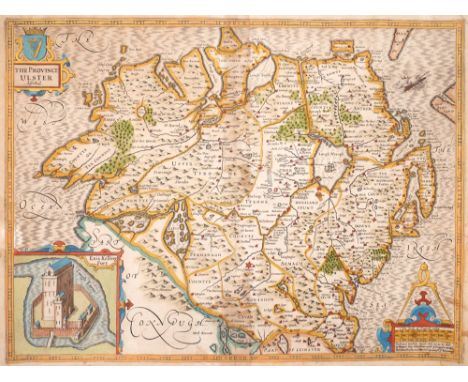
Lot 185
Early 17th century, map of Ulster by John Speed. John Speed 17th Century engraved and hand-coloured map of the province of Ulster with an inset oblique view of 'Enis Kelling fort'. The title, the Arms of Ireland and the scale displayed in decorative strapwork cartouches with the text 'Performed by John Speede and are to be solde by Roger Rae the Elder and younger at the Golden Crosse at Cornhill against ye Exchang'. Unframed. 15 by 19.75in. (38.1 by 50.2cm)


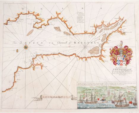
Lot 189
18th century, Map of Ireland by Richard W Seale, two charts and plans of the principle towns, forts and harbours. c1766: Dublin to Londonderry chart by George Grierson; 1744: A Map of the Kingdom of Ireland, by Richard W Seale 'From ye. latest & best Observations, for Mr. Tindal's Continuation of Mr. Rapin's History'; 1759 Plans of the Principal Ports, Towns and Harbours of Ireland for Mr Tindall's Continuation of Mr Rapin's History and c1774: the Severn or Channell of Bristoll - To the Right Honourable Sr. Robt. Southwell Kt. Who attended his Majty. K. William the 3d in his Expedition for Ireland in Quality of Principall Secretary of State for that Kingdom; (4) Unframed, the largest 19.50 by 24in. (49.5 by 61cm)

Lot 190
1777: Taylor, George and Skinner, Andrew. Taylor & Skinner's Maps of the Roads of Ireland, Surveyed. In original traveller's binding. Published for the Authors by G. Nicol London and W. Wilson Dublin 1778, tall 8vo. Pp xvi, 288 engraved maps on144 leaves, folding map of Ireland as frontispiece. 16 page list of subscribers. Early reversed calf on flexible boards showing wear to spine and all edges. The front endpaper inscribed, 'This book belongs to Richard Sutton of Ormond Quay and was used by him on a journey shortly after his marriage, 1777'

Lot 192
1794: Huddart Hydrographical Survey of the West Coast of Ireland A hand-coloured, engraved map, A new hydrographical survey of the West Coast of Ireland, from the Shannon Mouth to Urris Head, with part of the North Coast from Urris Head to Milk Haven being a continuation of the marine surveys made by Capt. J. Huddart. Framed.

Lot 193
1835 Map of Ireland by James Palmer. A hand-coloured, engraved map of Ireland, A New and Improved Map of Ireland Exhibiting the Mail Coach and Turnpike Roads, the Lakes, Rivers and Canals, The Principle Ranges of Mountains also the Borough and Market Towns, with their distances from the Capital, etc. dissected and mounted on linen in relief embossed cloth boards. 31 by 25in. (78.7 by 63.5cm)

Lot 194
1837 Lewis's Atlas and Gems of the Killarney Lakes. Lewis's Atlas Comprising the Counties of Ireland and a General Map of the Kingdom, London, 1837. 4to, brown watered silk covered boards gilt, lacking general map; together with Gems of the Killarney Lakes, The Emerald Isle Album Company, Dublin, c. 1904, 4to, gilt embossed card wrappers. (2)


Lot 210
1860 Map of Pennsylvania, New Jersey, Maryland and Delaware; a city plan of Philadelphia and a view of Philadelphia. A hand-coloured, engraved map by Samuel Augustus Mitchell of Pennsylvania, New Jersey, Maryland and Delaware; a colour lithograph plan of the Central part of Philadelphia published by W & AK Johnston Ltd.; and a hand coloured aquatint view of Philadelphia from Belmont. Unframed. (3) The largest 12.25 by 15.25in. (31.1 by 38.7cm)

Lot 215
Early 19th century map of Mexico and Guatemala. A hand-coloured, engraved map of Mexico before the Republic of Texas, showing the southern United States, Mexico and Central America. New Mexico is shown as a narrow strip of land along the upper Rio Grande River and most of New California is noted as 'Unknown Parts'. Unframed. 18 by 21in. (45.7 by 53.3cm)

Lot 216
Circa 1865. Maps of the Danish Islands in the North Atlantic Ocean. Hand-coloured engraved maps surrounded by pictures of the local people, animals, and impressive sights. The Iceland map includes a list of mountains with their elevations. The Royal Illustrated Atlas, Of Modern Geography, A. Fullarton & Co. London, Edinburgh & Dublin. Unframed. 18.50 by 12.50in. (47 by 31.8cm)

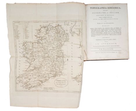
Lot 25
Seward, William W. Topographia Hibernica. Ancient and Modern. Giving a complete view of the Civil and Ecclesiastical State of that Kingdom; With its Antiquities, Natural Curiosities; Trade, Manufacturers, Extent and Population. Its Counties, Baronies, Cities, Burroughs, Parliamentary Representation and Patronage; Ancient Districts and their original Proprietors. Post, Market and Fair Towns; Bishopricks, Abbeys, Monasteries, Castles, Ruins Historical Anecdotes and Remarkable Events. With An Appendix containing some additional places and remarks and several useful tables. Alex Stewart, Dublin, 1795, first edition, 4to., full calf, folding map of Ireland and folding table.

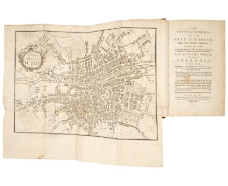
Lot 4
Harris, Walter. The History and Antiquities of the City of Dublin, from the Earliest Accounts: Compiled from Authentic Memoirs, Offices of Record, Manuscript Collections, and Other Unexceptional Vouchers. Published by Flinn & Williams., Dublin, 1766, 8vo, 509pp, folding map, folding table and two folding illustrations, quarter morocco gilt.

Lot 466
1960s Aer Lingus poster, Aasleagh Falls and a Bord Failte poster, Places of Scenic and Historic Interest. An Aer Lingus advertisement poster showing a view of Aasleagh Falls, Co. Mayo. Photograph by P. Tutty (Bord Failte) Irish Tourist Board. Colour lithograph by The Ormond Printing Co; together with an Irish Tourist Board (Bord Failte Eireann) poster of a map of Ireland with many vignettes of places of scenic and historic interest. Colour lithograph by Browne and Nolan, Dublin. Unrestored posters that display signs of use, rolled. Each 40 by 25in. (101.6 by 63.5cm)

-
109182 item(s)/page