We found 109198 price guide item(s) matching your search

Refine your search

Year

Filter by Price Range
  • List
  • Grid
  • 109198 item(s)
    /page

Lot 69

DONN (Benjamin) A Map of the County of Devon with the City and County of Exeter, Engraved by Thomas Jefferys. London: for the Author 1765, folio, hand coloured double page key map of the county and 12 section large scale map, the town plan single sheet uncoloured, light marginal staining and typical offsetting, in 19th century marbled boards and gilt lettered spine

Lot 7

Cambridge interest and others. Map of Cambridgeshire by Christopher Saxton and William Kip, loose uncoloured engraving, 17th century; Trinity College Great Court, engraving by Sparrow; British Railways Combined Excursion to Derby and Dovedale, lithographic poster printed by Stafford (unframed); two etchings by M. Oliver Rae; St Catharine's College, probably by Coronelli after Loggan c.1700; a hand coloured view towards King's College Chapel, 19th century, 13.5 x 22cm; together with various other prints, mostly framed (20)

Lot 70

TEESDALE (Henry, & Co) New Chart of the World on Mercator's Projection, with the Tracks of the Most Celebrated & Recent Navigators, engraved by John Dower, 1846, large hand coloured map in two folding sections, linen backed and dissected, with green fabric edging, both sections 131 x 99cm, in morocco gilt boards

Lot 71

[John Speed] A Map of Virginia and Maryland. London: Thomas Bassett and Richard Chiswell, [1676], engraved map with some outline colour, 39.5 x 53.5cm (sheet), English text verso, in double glazed gilt frame

Lot 72

C & J Greenwood. Map of London from an actual survey made in the years 1824, 1825 & 1826, published in 1827, 127 x 185cm, in tree calf caseA small pink wash smear to left side; tiny area (1cm ) oxidation to left side. A few small edge borders of paper sections folded in slightly and need flattening. Overall good original colour and universal tone. Please see images

Lot 86

[STRYPE (John)] Life of Sir Thomas Smith, 1698, 8vo, all rather browned, map at p.176, lacks portrait and Aa3 of appendix, rebacked calf; Historical Collections of the Life and Acts of the Rt. Rev. John Aylmer, Lord Bishop of London, 1st edition, 1701, 8vo, engraved portrait, panel calf, rebacked; Ecclesiastical Memorials, Relating Chiefly to Religion and its Reformation, under the Reign of King Henry VIII, King Edward VI, and Queen Mary the First..., 7 vols., 1816, 8vo, worn calf, rebacked (9)

Lot 89

[CHRISTYN, Jean-Baptiste] Histoire générale des Pais-Bas, contenant la description des XVII Provinces. Édition nouvelle. Brussells: Foppens, 1743, 4 vols. 8vo, folding map, plans and plates, frontispieces, internally clean, calf a little cracked; PUFENDORF (Samuel) Le Droit de la Nature et des Gens, ou Systeme General des Principes les plus importans de la Morale, de la Jurisprudence, et de la Politique. Translated from the Latin by Jean Barbeyrac, 2nd edition, 2 vols. Amsterdam: Chez Pierre de Coup, 1712, 4to, frontispiece portrait of Pufendorf, vignette titles in black and red, a little toned, contemporary calf (rubbed), chipped and missing labels (6)

Lot 189

RICHARD- YORKSHIRE-1722: REGISTRUM HONORIS DE RICHMOND- LONDON 1722, a rare and extensive large folio work on the early history of Richmondshire, its town and villages. Comprising over 450pp, in sections, appendices and indexes. Complete with all plates, mostly of coats and arms and armorial seals, including a folding map of Richmondshire and a folding view of the town with its castle and church.Printed by R. Gosling, Fleet Street 1722. Text in Latin Ownership signature on title page of Thomas Zouch (1737-1815) Divine and Antiquary (See extensive entry in DNB) Contemporary full leather binding, boards detached Ex. Lib

Lot 43

1904 Russo-Japanese war map 4th edition fold-out cloth map by W & A K Johnston - cover has slight water damage otherwise in virtually unused condition

Lot 44

1904 Russo-Japanese war map 9th edition fold-out paper map by W & A K Johnston - has some repairs t/w book The Russo-Japanese War 1904-1905 by Geoffrey Jukes

Lot 403

A Citizen Eco-Drive Whitehawk World Time gents wrist watch, ref. BJ9122-03A, cal. 6000 quartz movement, silver and white world map dial with rotating inner ring dial, gilt kite markers, lumed hands and date aperture at 4, 40mm. gold plated case, later black leather strap, no box or papers. * Condition: Not currently running - probably simply requires a new battery. Dial VG. Crystal has a tiny deep scratch at 4 o'clock. Light scratching to case from use and scratching to case back. Strap very worn.

Lot 7098

Palitoy Action Man Vintage a pair of British Military figures - both are flock head, Eagle Eye, gripping hands and dynamic body (1) Officer figure in Lancers uniform with field glasses and map; (2) Military Police with sub machine gun, pistol and baton - Fair to Good some powdery residue to caps may improve with cleaning, in white card display boxes. (2)

Lot 7114

Palitoy Action Man Vintage L348 Special Operations Tent "Can be Pitched Indoors or Out" - includes tent, poles, base, guy ropes, table, folding chair, map case and map, also includes instruction leaflet - contents appear generally Excellent in a Good original lift off lid box.

Lot 1485

A Commercial and Political Map of Southern Scotland and Adjacent English Counties, by Alexander Gross FRGS, dissected and laid on cotton, published produced by Geographia Ltd, London, 27.5 x 18 cm

Lot 1487

37 Ordinance Survey map copies relating to Whitley Bridge Exchange in North Yorkshire, including key plan

Lot 1491

A Victorian map of Westmoreland (Westmorland), watercolour tinted engraving, in Hogarth frame under glass, 29 cm x 23 cm overall

Lot 483

A 1940 British army chart / map board together with related maps of Britain

Lot 488

A 1941 British Army Mk III prismatic marching compass together with a map case

Lot 690

A brass chart / map magnifying glass, in a brass bound wooden box, together with another similar, former 7 cm unscrewed

Lot 1151

Two vintage German curvimeters / map measurers

Lot 1154

A Daystate Mk 4 Harper patent pre-charged bolt action air rifle, .177 caliber, MAP compensated technology, removable multi-shot magazine, shaped walnut stock, fitted with a moderator, instructions and charger present, in a slip case

Lot 110

After John Speed (1552-1629), a map of the Turkish Empire, dated 1626, published by George Humble at 'Popshead Alley', the cartouche depicting 'The Armes of Turkie', the border depicting figures and major cities, hand coloured engraving, 40 x 51.5 cm, framed and glazed, frame 64 x 74.5 cm; and a map of Hampshire, after John Norden, hand coloured engraving, 29.5 x 32 cm, framed and glazed, frame 53 x 54.5 cmQty: 2

Lot 114

Christopher Saxton and John Speed, The Kingdome of England, engraved by Jodocus Hondius 1610, hand coloured map, with panels depicting figures in native dress, published by John Sudbury and George Humble, Latin text verso, 39 x 52 cm, framed and glazed on both sides, 62 x 75 cm framed

Lot 91

After Philip Lea (1660? - 1700), Map of the Sea Coast of Europe its Straits, dedicated to Edward Earl of Orford, Admiral of His Majesty's Fleet and Treasurer to His Majesty's Navy, hand coloured engraving, published at the Atlas and Hercules in Cheapside and in Westminster Hall, 62 x 50 cm, framed and glazed, frame 81 x 68 cm

Lot 267

After Jan Jansson, a map of Moscow and nearby, 'Moscoviae Pars Australis, Auctore Isaaco Massa', hand coloured engraving, unglazed. H.59 W.71cm

Lot 62

Lucien Boucher (1889–1971) Air France map lithographic poster, 1948, condition A-; not backed Dimensions:24 x 39 in. (61 x 99cm.)

Lot 21

AFTER JOHN ROCQUE (1709 - 1762)Survey of the County of Dublin Four sheet map, each 560mm x 780mm; 580mm x 780mm (North East Sheet)North East sheet titled 'Chorographer and Topographer to His Majesty, London, Printed Rob(t) Sayer, Map and Printseller No.53 in Fleet Street', lacking cartouche and inset with rectangular box with title 'A Survey of/ The Parishes of Tippervevan/ Ballymore Eustace and Ballybought/ in the Barony of Uppercross and County of/ Dublin Lying very remote from ye rest of the/ said Country', ABL R 4.2(ii) pg. 359; Segment missing from the top left corner of the North West SheetSee ABL R 4.2 (i); (ii); R 4.3(i); R 4.4(i) for all four sheets

Lot 22

AFTER CHARLES BROOKING A Prospect of the City of Dublin from the North and A Map of the City and Suburbs of Dublin Handcoloured engraving, 590 x 900mm

Lot 23

A MAP OF THE STRAND OF THE NORTH SIDE OF CHANNEL OF RIVER ANNA LIFFE, 1811Engraving, 680 x 480mmAs it was granted and set about in Easter Assembly, 1717 by T. Bolton, Lord Mayor and the deeds and this map perfected in the mayoralty of A. Barkey. This is a later edition from 1811 which includes the addition of the Royal Canal. ABL G 5(ii) 

Lot 26

JOANNES JANSSON (1588 - 1664)Province of Ulster Handcoloured engraving, 380 x 480mmAs text is potentially covered by frame or lacking, cannot give exact date of map other than 17th century as there is almost no variation to the map itself. ABL p.29

Lot 32

GERARD MERCATOR (1512 - 1594)'Irlandiae Regnum', North and SouthEngraved map, two sheets, 340 x 470cmFrench text versoc.1628- 1633 French edition of Mercator and Jodocus Hondius's "Atlas" originally published 1595

Lot 33

GERARD MERCATOR (1512 - 1594)'Irlanda Regnum'Engraved map, 330 x 420mm 1621 edition published in Arnheim by Jansson

Lot 35

JOHANN BAPTISTE HOMANN (1664 - 1724)'Hiberniae Regnum'Engraved map, 580 x 480.5mm1726 ABL 63 (ii)

Lot 403

LABORDE, Léon de (1807-1869)Journey through Arabia Petraea to Mount Sinai, 2nd ed., London: (John Murray), 1838 f/o map and plates;OLIPHANT, LaurenceThe Russian Shores of the Black Sea, 3rd ed, London: (William Blackwood & Sons), 1854 f/o map and illustrations in text;CURZON, RobertArmenia, 1st ed., London: (John Murray), 1854 engravings all half morocco over marbled boards with crimson labels on paste downs lettered in gilt 'C.T. McC' (3)

Lot 405

STEPHENS, John L.Incidents of Travel in Central America, Chiapas and Yucatan, 2 vols., new ed., London: (John Murray), 1842, f/o map and plates- Incidents of Travel in Yucatan 2 vols., London: (John Murray), 1843 f/o map and plates in uniform brown pig skin binding with gilt lettering marble bands, crimson morocco labels and front paste-downs lettered in gilt 'C.T. McC'*a good set, there is mis pagination in Vol. I, but otherwise appears to be complete but sold w.a.f. (4)

Lot 406

DU CHAILLU, Paul (1831-1903)Explorations and Adventures in Equatorial Africa, London (John Murphy) 1861, f/o lithograph Map 'Western Equatorial Africa showing the country explored by P.B. du Chaillu 1856, 57, 58 & 59,' with the 73 full-page and in text steel engravings as called for (no. 1 f/o The Gorilla, torn across lower fold), some pages loose, half black morocco, compartmented spine lettered in gilt.

Lot 82

AN EARLY 19TH CENTURY FOLIO / MAP STAND,the adjustable slatted sides on a ratchet supports, collapsing to a flat surface, raised on trestle legs with brass toe caps and castors. 70cm wide x 100cm high

Lot 163

Isle Of Wight. John Speed (1552-1629) Map of 'Wight Island'John Sudbury and George Humblea mid 17th century map with near period sparse outline colouring, inset town plans of Newport Southampton, border with heraldic shields, text verso, framed, double glazed within mount 50.5 x 38cm., overall 57x 68cm.Condition:Colouring bright. Very slight minor tears / creases with repairs on the fold. Old repair to bottom left hand corner

Lot 164

Isle of Wight: Pieter Van Den Keere (1571-c.1646) Map of 'Wight Island'1627, engraving with hand colouring, mounted, framed within mount 8.5x 12cm., overall 21 x 26cm.Condition:Good condition

Lot 14

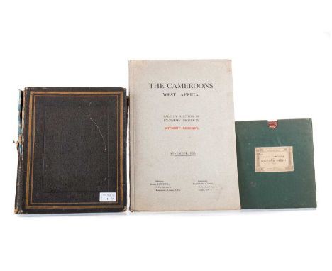
THE CAMEROONS WEST AFRICA, CATALOGUE FOR THE SALE BY AUCTION OF EX-ENEMY PROPERTY NOVEMBER, 1924 in drab boards, Solicitors: Messrs. Burchell, Auctioneers: Hampton & Sons, Without Reserve, No Restriction as to Nationality of Purchasers, By direction of the Custodian of Enemy Properties for H.M. Government... Particulars, Plans and Conditions of sale of the Cacao, Oil Pam & Rubber Plantations of various areas from 200 to 35,000 acres... upon which are Manager's bungalows, Overseers', Artizans' and Labourers houses, Hospitals, Cacao and Rubber curing factories and stores, furniture, tools, etc., banana, sugar and tobacco lands, light railways, rolling stock, locomotices, bridges, machinery and saw mills..., along with a period photograph album and Ordnance Map of Southern Nigeria (1910) (3)Approx. 26 photographs in the album.

Lot 21

ALLEN'S MAP OF INDIA, ALLEN (WILLIAM H.) PUB. WM. H. ALLEN & CO, LONDON 1849 linen backed folding map in gilt tooled cloth boards96cm x 84.5cm

Lot 813

Nigel Houndsworth, a signed fisherman's map of the salmon pools on the River Dee, 33 x 97 cm, framed and mounted.

Lot 15

A Weihrauch HW80K cal 22 break barrel air rifle, fitted with a Hawke Map Pro 3-9 x 50 AO telescopic sight and bag. Serial No. 1518419. WE CANNOT POST AIR GUNS TO PRIVATE ADDRESSES. POSTAGE TO RFD'S ONLY.

Lot 806

Two books, "Swimming Against The Tide, Restoring Salmon To The Tyne" by Peter Grey and Michael Charlston, signed by Peter Grey and "Where To Fish 1957-1958" by Roy Eaton, containing a fold out map of river catchment areas.

Lot 336

World War II German Aeronautical Survey Map 36x32 Wales and Midlands area. All autographs are genuine hand signed and come with a Certificate of Authenticity. We combine postage on multiple winning lots and can ship worldwide. UK postage from £5.99, EU from £7.99, Rest of World from £10.

Lot 290

An album of approx. 114 postcards mainly German photo topo including early street scenes, dog carts, other foreign and a few GB c.1900 – 1905 together with an early folding road map of North London etc

Lot 462

A quantity of unframed posters and prints including Map of the World, glamour models Sam Fox and Lucinda Lusardi c.1980’s and others

Lot 86

Vintage Map of East Anglia 103x77cm

Lot 91

The History of Scotland of George Buchanan by J Aikman in 6 volumes 1827 Blackie with folding colour map

Lot 117

A 20th century diorama map of the battle of Stirling bridge, 74cm high x 181cm wide Condition Report:Available upon request

Lot 1029A

A VINTAGE ORDNANCE SURVEY MAP OF HAYFIELD, HIGH PEAK

Lot 417

Three hardback antiquarian books; Maynard, George Henry, LL.D. 'The Whole Genuine and Complete Works of Flavius Josephus, a learned and authentic Jewish Historian', illustrated, printed for C. Cooke, Pater-noster Row, recently rebound copy in cloth cover, Hamilton Moore, John, 'A New and Complete Collection of voyages and travels', illustrated, printed for Alex Hogg, at no. 16 Pater-noster row, Moroccan leather spine and marbled boards (with hand written date 17?), leather bound volume of 'The Booke of Common Prayer' 1607, imprinted at London by Robert Barker, printer to the King's Most Excellent Majesty. (3) (B.P. 21% + VAT) All have minor foxing and stains to interiors, some with small tears to pages, and wear to edges of pages. Covers all damaged or replaced by a modern cover.The John Hamilton Moore book - has a fold out map at the beginning and two maps in the text, 48 single and 5 double engravings approx. Last page is 592 (may be missing pages)   No manuscript record of the original owning family of the 1607 bible, but stamp and some hand written script.  there is an original owner's signature in 'Voyages'.  Please see additional images.

Lot 254

POSTCARDS, four albums containing approximately 685* modern 'Map' Postcards (mid-late 20th century, most regions of the Great Britain and Ireland represented

Lot 201F

A Michelin Tyres metal advertising sign, featuring the Map of the UK, 87cm x 72cm.

Lot 250

An RAC map of England and Wales and the Lowlands of Scotland, on laminated finish with paper backing, 60cm x 46cm.

Lot 2291

Two volumes of Rayleigh history ,1908 &1932. As well as an excursions in Essex book with map and engravings, 1819. (B)

Lot 302

Groninga, Stratingh, G.A. and Venema, G.A. The Dollard, or historical, geographic and physical description of this bosom of the Eems. With title print and 2 folding lithographed maps and 1 folding map in black and white. Groningen, J. Oomkes, 1855 (newly bound).

Lot 326

Groningenana; A.J. de Sitter. Present state of the United Netherlands; twentieth and twenty-first. Volume: Description of City and Country. Complete in 2 volumes, with 7 folding copper engravings, 1 title print and 1 folding map, Amsterdam () 1793. Orig. Leather with beautifully stamped spine, tot. 3x.

Lot 464

A French patinated spelter and marmo Portoro mounted desk lamp modelled with a figure of Napoleon Bonaparte, early 20th century; the general portrayed as seated at a table, with an opened map and a lantern, with electrical fitment within; the marble base with applied plaque, VEILLE DE BATAILLE; 19cm high, 27cm long, 15cm wide

Lot 9043

A box of mixed militaria including wartime water bottle, 1944 map case etc

Loading...Loading...
  • 109198 item(s)
    /page

Recently Viewed Lots