

SHROPSHIRE INTEREST: Greenwood (C. & J.), "Map Of The County Of Salop From An Actual Survey Made In The Years 1826 & 1827, Published July 2nd", large scale engraved map with contemporary hand colouring, sectionalised and laid on later canvas, calligraphic title, compass rose, table of explanation and a vignette of the south west prospect of Shrewsbury, inset map of part of Shropshire, signed "James Boydell" in brown ink below title, top and bottom stained beech rails, repaired tears to top left and top right panels, the map 149cm x 121cm, overall 105.5cm x 128.5cm (minor faults) Provenance: From the personal collection of Russell Grant. CONDITION REPORT:There are two repaired tears to the top panels as noted in the description above. There are visible joins between the sectional panels, but all are secure on the backing canvas. The canvas is later. The rails appear to have been added with the linen backing. The piece does not hang perfectly flat.
We found 109182 price guide item(s) matching your search
There are 109182 lots that match your search criteria. Subscribe now to get instant access to the full price guide service.
Click here to subscribe- List
- Grid
-
109182 item(s)/page
![Kitchin (Thomas), A NEW IMPROVED MAP OF OXFORDSHIRE From The Best Surveys And Intelligences, Divided Into Hundreds[...], engr](https://cdn.globalauctionplatform.com/909dc926-9be4-4786-9b0d-aeb30096f227/b55546e8-afbf-4c46-97e0-aeb600a0cdba/468x382.jpg)
Kitchin (Thomas), A NEW IMPROVED MAP OF OXFORDSHIRE From The Best Surveys And Intelligences, Divided Into Hundreds[...], engraved and hand-coloured map on laid paper, visible plate mark, title cartouche to lower left corner, dedication cartouche to top right corner, undated but likely circa 1760, unframed, 75.7cm x 53.5cm overall, with a selection of further unframed maps to include SHROPSHYRE after John Speed, EBORACENSIS WEST RIDING after Christopher Saxton, MAP OF THE COUNTY OF STAFFORD by C. & J. Greenwood & Co, and a miscellany of further maps and prints (Qty) (at fault)

After Emanuel Bowen (1694-1767), a hand-coloured map titled "An Accurate Map Of The County Palatine Of Chester, Divided Into Its Hundreds..." hand-coloured title vignette lower left, dedication cartouche lower right, framed and glazed, 59cm x 75cm overall, with two further framed and glazed maps of The County Palatine Of Chester after Blome (32cm x 36.5cm) and Moll (23.5cm x 35.5cm), and a framed and glazed map of Cheshire (29.5cm x 24.5cm) (4)

After Jan Jansson (Dutch, 1588-1664), a hand coloured map titled 'Cestria Comitatus Palatinus. The Countye Palatine Of Chester', hand-coloured coats of arms, title vignette and scale vignette, framed and double glazed with Latin text verso, 38.5cm x 50.5cm overall, with a further framed and glazed map of "The County Palatine Of Chester" published by Overton (45.5cm x 58cm) and "A New Map Of The County Palatine Of Chester" printed for C. Smith and dated 1821 (64cm x 68cm) (3)

After Robert Morden (British, 1650-1703), a hand-coloured map titled "The County Palatine Of Lancaster", framed and glazed, 56cm x 50cm, with a further framed and glazed hand-coloured map after Morden titled "Cumberland" and later dated "1695", 40cm x 46cm, and a framed and glazed map of the Eastern Hemisphere after J. Rapkin published by John Tallis in his Illustrated Atlas, 47.5cm x 54.5cm (3)

After John Speed, a map titled "CAERNARVON BOTH SHYRE AND SHIRE-TOWNE WITH THE ANCIENT CITY OF BANGOR DESCRIBED, laid paper, visible plate mark, later coloured, to be sold by Thomas Bassett and Richard Chiswell, English text verso, central join, in double sided glazed frame, 42cm x 55cm overall, with a further map by Speed titled "HARTFORD SHIRE DESCRIBED", laid paper, visible plate mark, later coloured, to be sold by John Sudbury and George Humbell, English text verso, central join, in double sided glazed frame, 43.5cm x 56.5cm overall, and a further framed map of Caernarvonshire after Christopher Saxton titled "CAERNARVO COMITATUS PARS OLIM ORDOVICUM, 39cm x 44cm overall (3)

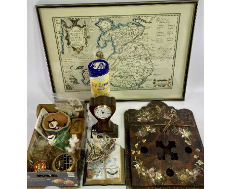
MIXED GROUP OF COLLECTABLES - to include a painted papier mache letter holder, 40 x 30cms, waisted form inlaid mahogany mantel clock with modern Quartz movement, 18cms H, small mauchline ware money box with image titled 'Glasgow from the Clyde', coral and shells, woven cigarette card type silks, vintage postage stamps and other items of interest including a framed reproduction map of Wales, 43 x 57.5cms
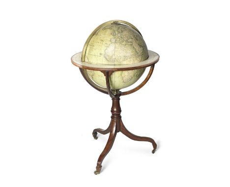
AN 18-INCH CRUCHLEY'S TERRESTRIAL GLOBE ON A STAND Cruchley of London, English, Mid-19th centuryThe sphere with printed and hand coloured gores, mounted in a brass meridian engraved with four quadrants, mounted within horizon ring applied with zodiac and calendar scales, raised on four mahogany brackets above turned column and tripod base, with brass castors, 103cm (40in) high Footnotes:Inscription reads: CRUCHLEY'S / NEW / TERRESTRIAL GLOBE / From the most recent Authorities / EXHIBITING THE DISCOVERIES IN EQUATRORIAL / AFRICA, NORTH POLE / And the new Settlements & Districts of / AUSTRIALIS, NEW ZEALAND, / CALIFORNIA, TEXAS &C. / LONDON / G. F. CRUCHLEY, MAP-SELLER, GLOBE MAKER & PUBLISHER / 81 FLEET STREETThis lot is subject to the following lot symbols: TPTP Lot will be moved to an offsite storage location (Cadogan Tate, Auction House Services, 241 Acton Lane, London NW10 7NP, UK) and will only be available for collection from this location at the date stated in the catalogue. Please note transfer and storage charges will apply to any lots not collected after 14 calendar days from the auction date.For further information on this lot please visit Bonhams.com


Group of 17th / 18th / 19th century maps, including John Ogilby, The Continuation of The Road from Chester to Cardiff, Herman Moll map of Essex, small 17th century map of Essex, The Road from Kings Lynn to Norwich, and South Africa, all in glazed frames. (5)Multiple additional images now published attached to this lot online
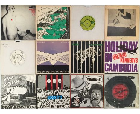
PUNK/ WAVE - 7" COLLECTION. A quality collection of around 80 7" singles. Artists/ titles include Wire inc Mannequin (HAR5144), Map Ref (HAR5192), I Am The Fly, A Question Of Degree, Free EP (PSR 444), Dot Dash, Outdoor Miner. Dead Kennedys inc Holiday In Cambodia, Kill The Poor, Californi Uber Alles, Halloween, Nazi Punks-Fuck Off, Too Drunk To Fuck, Bleed For Me, Buzzbomb (flexi disc). The Boys - I Don't Care. Black Flag - Six Pack, Bauhaus - Telegram Sam, Anti-Pasti - Let Them Free. Boomtown Rats, Bow Wow Wow, Magazine, The Members, New Model Army inc Bittersweet, The Price, Better Than Them. Chumbawamba, East Bay Ray, The Cortinas, Alternative TV, Xray Spex. Condition is generally VG to Ex.

STRACKE LEO WILHELMUS (1897-1963), sign. and dated. 1934-1938, A set of 10 cityview, among which Antwerp, Bruges, and Oudewater, mix. media, div. sizesSTRACKE LEO WILHELMUS (1897-1963), ges. en gedat. 1934-1938, Map met 10 stadsgezichten, w.o. Kuipersstraat Antwerpen, Brugge, kerk te Oudewater, gemeng. tech. , div. maten


DIVERS, signed. Folder with multiple works on paper, incl. woodcut, watercolour, print, diverse artists incl. Gene Egge, Godfried Pieters, Harry Kanoen and more.Map met diverse techniek, w.o. gesigneerd w.o. houtsnede, gouache, zeefdruk. met onder andere werken van Gene Eggen, Godfried Pieters, Harry Kanoen en meer.


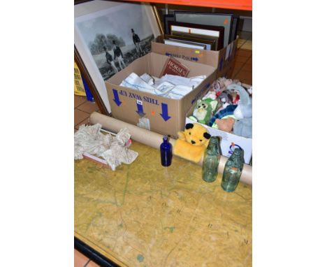
THREE BOXES AND LOOSE PICTURES, MAP, LINENS, SOFT TOYS AND SUNDRY ITEMS, to include a canvas backed copy of a map of Leicestershire and surrounding areas, originally published in 1834, with hanging poles, a box of soft toys including TY Beanie Babies, Bugs Bunny, Sootie and a 1990s/early 2000s Furby, ten framed prints largest approximately 85cm x 68cm, assorted vintage household linens and lace, two Codd bottles, etc (sd) (3 BOXES AND LOOSE)

TWENTY SIX ANTIQUE MAPS, MOSTLY OF STAFFORDSHIRE, to include Jan Johnsson circa 1650, approximate size 43cm x 54cm, Joan Blaeu circa 1655, John Speed 1743 edition, Jan Jansson 1683 edition published by Schenk and Valk, Robert Morden 1722, Christopher Saxton 1637 edition, Emanuel Bowen 1755, Thomas Jenner?? distance calculator circa mid 1700's, three London to Chester coach road maps, John Speed Stafford Town map, Thomas Kitchen 'New Map of Staffordshire', J Ellis 'Modern Map of Staffordshire', etc

TWENTY ANTIQUE MAPS RELATING TO WARWICKSHIRE, to include Christopher Saxton 1576 amended 1603, approximate size 40cm x 48cm, John Speed 1630 later hand colouring, Robert Morden circa 1695, Robert Morden published by T Cox C1730-1739, Thomas Read 1769 issue, Thomas Jefferys from 'The Small English Atlas', 1748/9, John Seller (small) from Anglia Contracta 1695, two Badeslade and Toms 1741, Gibson 1759, Emmanuel and Thomas Bowen, Herman Moll 1724, James Pigot circa 1830, Bowles 'New Medium Map of Warwickshire' 1785, a distance calculator circa 1662, warwick /Warici by Christopher Saxton / William Kip, Joan Blaeu 1645 a small map approximate size 9cm x 5.5cm and two others
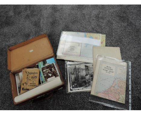
A collection of Ephemera including Military Ordnance Survey Maps small scale 1923, Map Kew Garden 1946, Foreign Bank Notes, WW2 double sided Silk Escape Map for Burma Siam French Indo China, Daily Telegraph War Map of Finland and Scandinavia with the Baltic States, The Popular Wireless Broadcasting Map of the World, Postcards and Photographs along with four large Photographs of the Atomic Energy Research Department 1948, in small leather case

Multi signed blue Premier League referee jersey, season 2021-22, match-issue, Nike, short-sleeved with EA SPORTS sleeve badges, two breast pockets, one bearing Premier League logo, signed on front in black marker pen by 17 Select Group 1 Premier League referees, including Martin Atkinson, Craig Pawson, Peter Bankes, Rob Jones and others, see image for signature map Complete with a Graham Budd Auctions Certificate of Authenticity. All profits will be donated to the Essex & Hertfordshire Air Ambulance.

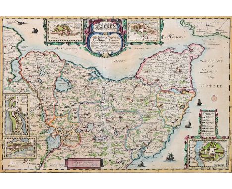
Karte von Ostholstein, um 1650Kupferstichkarte auf Bütten, kol., dekorative Titelkartusche mit gestoch. Bez. "Nordertheill. Von Wageren/ worinnen auch die ämpter Cißmar und Oldenborg/ Anno 1649". A. L. Rothgiesser n. J. Meyer. Hinter Glas mit Pp. gerahmt. PA 42,5 x 61 cm, 56 x 75 cm (Ra.) Dekorative Karte, an Rand Stadtpläne von Lütjenburg, Heiligenhafen u. Neustadt. Am linken Rand 2 weitere Grundrisse von Preetz und Plön. Zeigt das östl. Holstein mit Probstei, Holsteinische Seenplatte und Kreis Oldenburg. Map of Holstein, copper etching, coloured, including maps of five cities. By A. L. Rothgiesser after J. Meyer. Ca. 1650. Framed with glass and passepartout. Frame 56 x 75 cm
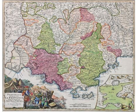
Landkarte von Südfrankreich/ Provence, um 1720Kupferstichkarte auf Bütten, grenz-und flächenkoloriert, li. u. interessante figürl. Kartusche mit einer Illustration der Spanischen Erbfolgekriege: Adlige mit Edelmetall vor General Villars, gestoch. Titel "Provincia Indigenis dicta La Provence". Re. u. Schlachtplan der Schlacht von Toulon 1707. Verlag J. B. Homann Nürnberg. Re. unt. Ecke kl. Ausriss. 48,5 x 57 cm (PA), hinter Glas mit Pp. gerahmt. Ra. 64,5 x 72 cm Die Karte erstreckt sich über die Region von Arles bis Monaco. Map of Southern France, copper etching, coloured, editor: J. B. Homann Nürnberg. Ca. 1720. Slight damage lower right corner. Framed with glass and passepartout. 64,5 x 72 cm (size incl. frame)
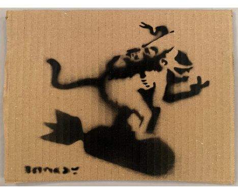
BANKSY DISMALAND BANKSY ORIGINAL DISMALAND Bombe aérosol et pochoir sur carton, signé et numéroté à 50 exemplaires.Art gratuit de la peinture en aérosol au pochoir semé au parc à thème de Banksy "Dismaland" qui s'est tenu pendant deux mois, d'août à septembre 2015. Pendant la période d'exposition, Dismaland a organisé un Art Libre où ils cachent l'œuvre à divers endroits et vous pouvez l'emporter chez vous. (Certains dommages sur le carton en sont la cause.) Livré avec ticket original d’entrée et Map Dismaland. Dimensions 20 x 27,5 cm environ
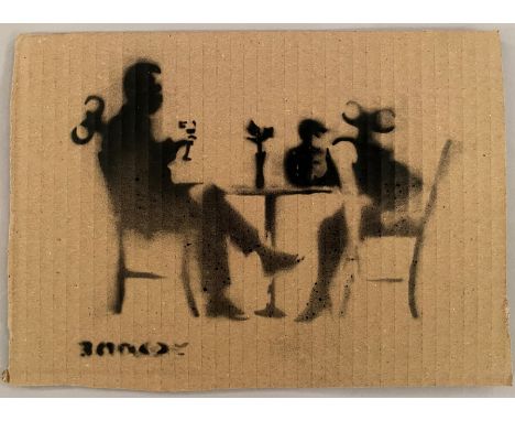
BANKSY DISMALAND BANKSY ORIGINAL DISMALAND Bombe aérosol et pochoir sur carton, signé et numéroté à 50 exemplaires.Art gratuit de la peinture en aérosol au pochoir semé au parc à thème de Banksy "Dismaland" qui s'est tenu pendant deux mois, d'août à septembre 2015. Pendant la période d'exposition, Dismaland a organisé un Art Libre où ils cachent l'œuvre à divers endroits et vous pouvez l'emporter chez vous. (Certains dommages sur le carton en sont la cause.) Livré avec ticket original d’entrée et Map Dismaland. Dimensions 20 x 27,5 cm environ
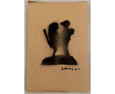
BANKSY DISMALAND BANKSY ORIGINAL DISMALAND Bombe aérosol et pochoir sur carton, signé et numéroté à 50 exemplaires.Art gratuit de la peinture en aérosol au pochoir semé au parc à thème de Banksy "Dismaland" qui s'est tenu pendant deux mois, d'août à septembre 2015. Pendant la période d'exposition, Dismaland a organisé un Art Libre où ils cachent l'œuvre à divers endroits et vous pouvez l'emporter chez vous. (Certains dommages sur le carton en sont la cause.) Livré avec ticket original d’entrée et Map Dismaland. Dimensions 20 x 27,5 cm environ
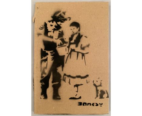
BANKSY DISMALAND BANKSY ORIGINAL DISMALAND Bombe aérosol et pochoir sur carton, signé et numéroté à 50 exemplaires.Art gratuit de la peinture en aérosol au pochoir semé au parc à thème de Banksy "Dismaland" qui s'est tenu pendant deux mois, d'août à septembre 2015. Pendant la période d'exposition, Dismaland a organisé un Art Libre où ils cachent l'œuvre à divers endroits et vous pouvez l'emporter chez vous. (Certains dommages sur le carton en sont la cause.) Livré avec ticket original d’entrée et Map Dismaland. Dimensions 20 x 27,5 cm environ
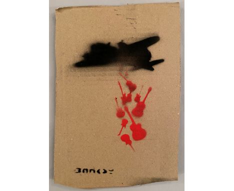
BANKSY DISMALAND BANKSY ORIGINAL DISMALAND Bombe aérosol et pochoir sur carton, signé et numéroté à 50 exemplaires.Art gratuit de la peinture en aérosol au pochoir semé au parc à thème de Banksy "Dismaland" qui s'est tenu pendant deux mois, d'août à septembre 2015. Pendant la période d'exposition, Dismaland a organisé un Art Libre où ils cachent l'œuvre à divers endroits et vous pouvez l'emporter chez vous. (Certains dommages sur le carton en sont la cause.) Livré avec ticket original d’entrée et Map Dismaland. Dimensions 20 x 27,5 cm environ
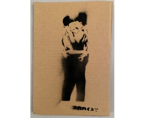
BANKSY DISMALAND BANKSY ORIGINAL DISMALAND Bombe aérosol et pochoir sur carton, signé et numéroté à 50 exemplaires.Art gratuit de la peinture en aérosol au pochoir semé au parc à thème de Banksy "Dismaland" qui s'est tenu pendant deux mois, d'août à septembre 2015. Pendant la période d'exposition, Dismaland a organisé un Art Libre où ils cachent l'œuvre à divers endroits et vous pouvez l'emporter chez vous. (Certains dommages sur le carton en sont la cause.) Livré avec ticket original d’entrée et Map Dismaland. Dimensions 20 x 27,5 cm environ
-
109182 item(s)/page