We found 109182 price guide item(s) matching your search
There are 109182 lots that match your search criteria. Subscribe now to get instant access to the full price guide service.
Click here to subscribe- List
- Grid
-
109182 item(s)/page


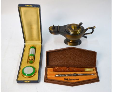
Lot 1039
A 1954 vintage Longchamps leather travel pocket-book, fitted with a Michelin map of France - unused in original box - to/w 19 Adolph Joanne French folding pocket maps published by Libraire Hachette (c 1900), a cased lipstick and powder compact with mother of pearl and green enamel by Lancel, a Dunhill 'Roman Lamp' table lighter and a vintage Waterman's pen-box etc


Lot 1032
BIBLE, Authorized Version, Robert Barker, London 1613, 8vo approx. 11 x 16cm, old embossed calf, rear board detached, lacks main title and all before 3 leaves of genealogies and map and description of Canaan, includes Apocrypha to Maccabees II, Sternhold & Hopkins Whole Book of Psalms at back lacks all after Psalm 131, Genesis i,2 "void and darknesse", x. 16 "Emorite", Ruth iii, 15 "she", Matthew i.23 "foorth" (1) Condition Report / Extra Information Red ruled.Some browning of pages.


Lot 462
William Arnold Bromfield - Flora Vectensis being the Systematic Description of the Phaenogamous or Flowering Plants and Ferns Indigenous to the Isle of Wight, published by William Pamplin 1856, folding map mounted on linenCONDITION REPORTpoor condition, boards completely loose, pages not checked, the Bontico topographical map is original and integral, 15 section map has two tears to right hand side and is separating at folds, tape to left hand side outside margin


Lot 1152
FOOTBALL MISCELLANY Collection of programmes, some signed 3 photos (all signed by Gary Mabbutt), Badge patches, Bristol Rovers, Rosette from the 1950's East German (DDR) Youth tournament pennant 1980, football map etc. Signed programmes Western Australia v England Schoolboys 1970's signed by Mabbutt and Kenny Sansom, Manchester City v QPR 74/75 signed by 16, signed Gary Mabbutt Testimonial Brochure x 2 signed sheet signed by 13 Tottenham players inc Perryman, Steven Falco, Roberts, Hazard etc. Fair-generally good


Lot 1330
'A NEW PLAN OF THE CITY AND LIBERTY OF WESTMINSTER, EXHIBITING ALL THE NEW STREETS AND ROADS WITH THE RESIDENCES OF THE PRINCIPAL NOBILITY, PUBLIC OFFICES ETC', a hand coloured map of the city of London, by Thomas Jefferys 1766, 18.5" x 37". Provenance: A note to the reverse, 'Purchased by me from a street vendor on St. Christopher's pavement, in exchange for one 'Luncheon Voucher', value three shillings in 1962'.


Lot 1141
SAXTON, C and LEA, P; a late 17th century map of Essex, with vignette town plan of Colchester lower right, 43 x 54cm, framed and glazed. CONDITION REPORT: 1cm Margin, section to the centre is white to the sides are brown stained a few small creases to edges. Please refer to additional pictures


Lot 1138
SPEEDE, JOHN; a late 17th century and later hand coloured map of Chester, 39 x 51cm, a further 17th century black and white engraving "Collegium Goneville et Cajus Cantb", 36 x 49cm, two coloured etchings "The United States New Mail Ship" and "Adriatic 1857", framed as one and a further signed example depicting street scene, all framed and glazed (4).

-
109182 item(s)/page