

Original vintage travel poster - Tanganyika becomes a sovereign nation - featuring a small inset marking Tanganyika on the map of Africa. Information on population and political, financial, and technical advance of the country after help from Asia, Europe, and Britain. Photographs below portray Dar es Salaam - the capital, seat of government, chief port and commercial centre, an important outlet for the export trade; pupils by school; sisal production; lady with a baby at a coffee plantation; giraffes on a plain; outside view of the Princess Margaret Hospital and a ward in the hospital with doctors in white and nurses in pink uniforms; vocational and technical education at trade schools; diamond mining; people at a conference agreeing on constitutional proposals; community centre used for adult education classes, socials and sport, with ladies in colourful dresses playing ball in the yard; a man in the field of maize captioned - The European community consists of farmers, businessmen civil servants and missionaries; textile mill factory. Printed in England for H.M. Stationery Office by Clarke & Sherwell Ltd., Northampton. Horizontal. Good condition, creasing, folds, repaired tears, tears, tape on reverse. Country of issue: UK, designer: Central Office of Information, size (cm): 75x100, year of printing: 1961
We found 109198 price guide item(s) matching your search
There are 109198 lots that match your search criteria. Subscribe now to get instant access to the full price guide service.
Click here to subscribe- List
- Grid
-
109198 item(s)/page

Original vintage travel poster - Jamaica becomes a sovereign nation - featuring a small inset map of Caribbean Sea and Atlantic Ocean showing location of Jamaica with USA and South America marked. Information on population, area, production, and exports is accompanied by photographs captioned: Palisadoes airport - Many air and shipping lines serve Jamaica. Kingston, King Street - This is the island's capital and main port. Suburban housing - House-building is aided by the government. Beach-hotels for tourists - Tourists spend some £12 million a year in Jamaica. Facilities are being improved to attract more visitors. Bauxite yields aluminium - Bauxite exports are worth over £30 million a year. Sugar-cane harvest - Sugar, molasses and rum are made from the cane. Blue mountain coffee - Coffee beans are sorted and graded for export. Fruit canning - This is one of a variety of new industries. Children in hospital - Jamaica has 26 hospitals and 134 health centres. Education - British aid to schools and to the West Indies University college exceeds £2 million. Printed in England for H.M. Stationery Office by Clarke & Sherwell Ltd., Northampton. Horizontal. Good condition, folds, creasing, minor foxing, pin holes. Country of issue: UK, designer: Central Office of Information, size (cm): 75x97, year of printing: 1962

Original vintage travel poster advertising Richmond Yorkshire for British Rail, designed by Edward Wesson (1910-1983). The painting depicts Richmond castle on a hillside, with houses beneath, smoke coming from their chimneys, surrounded by trees. The River Swale runs towards the viewer, with a bridge with arches crossing over it, beneath a blue sky with white clouds. Underneath the painting, white text on a yellow background gives information about Richmond, next to a map of Great Britain with Edinburgh, Newcastle, Darlington, Richmond, York and London highlighted on a train route. Richmond Castle is one of Britain's finest Norman castles and was occupied by the northern Non-Combatant Corps during WWI. Published by British Railways North Eastern Region and printed in Great Britain by Stafford & Co LTD, Nottingham. Very good condition, creasing, minor staining. Country of issue: UK, designer: Edward Wesson, size (cm): 102x63.5, year of printing: 1960s
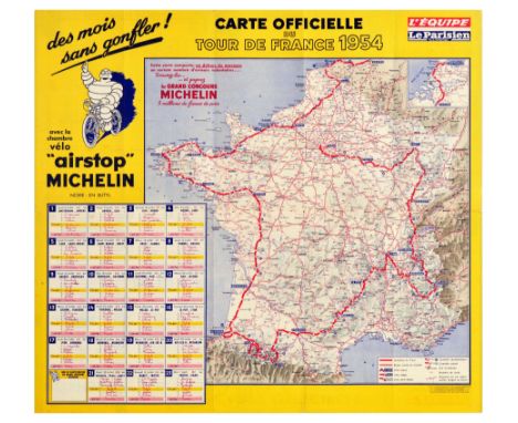
Original vintage official fold-out map of the 1954 Tour de France route, sponsored by Michelin. The map marks the route of the race from Amsterdam to Paris in red - next to the map is a chart showing each stage of the tour, the date and the distance, with spaces to record the winners of each day. The surrounding border is yellow with stylised writing in black, the L’Equipe Le Parisien logo, and an image of Bibendum the Michelin mascot riding a bicycle, advertising ‘airstop’ Michelin. The reverse of the map features information on the stages of the tour and on the teams, a box containing information on the winners of the previous 41 Tours de France (the first of which took place 1903), and advertisements for Michelin products. The 1954 Tour de France was won by French road cyclist Louison Bobet - the second of his three consecutive Tour de France wins. Good condition, folds, tears, small paper loss, stain, calendar filled out in red ink, double sided. Country of issue: France, designer: Unknown, size (cm): 50x55, year of printing: 1954
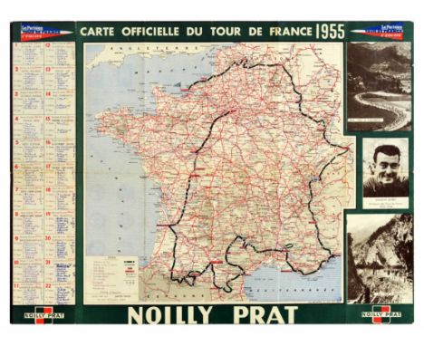
Original vintage sport poster Official map of the Tour de France 1955, with photographs of Tour de France locations - Pau, Cauterets, Briancon, the winner of the 1953-1954 race Louison Bobet, and handwritten marks for each day of the race, and road signs, vehicle registration indicators, and abacus of the kilometric distances between all the prefects on the reverse. 1955 Tour de France was held 7-30 July, and was won by French bicycle racer Louison Bobet, third time in a row, with Belgian Jean Brankart in second, and Charly Gaul of Luxemburg in third. With an advertising of Noilly Prat, a vermouth brand from France owned by Martini & Rossi. Printed by Michard. Good condition, folds, foxing, staining, tears, small paper losses, filled out in blue ink, double sided. Country of issue: France, designer: Unknown, size (cm): 46x61, year of printing: 1955
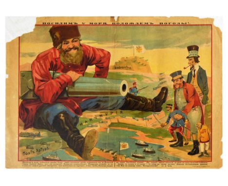
Original vintage propaganda poster from the Russo-Japanese War (1904-5) titled Posidim u Morya, Podozhdom Pogody! / We Will Sit by the Sea and Wait for the Weather! The image shows a large smiling Russian man holding a canon, sat on a map labelled Manchuria. He aims the gun at a group of figures who represent China, Japan, Britain and the US. Port Artur is depicted in the foreground with battleships in the water. The image is surrounded by a red border with a poem by D. Gusev beneath translating to - Let's sit by the sea, wait for the weather! Do you see what terrible freaks are seen from behind the Japanese back, they must be his guardians? Overseas patrons? Gentlemen, would you like a smoke of our Russian makhorka (low grade smoking tobacco) that you can see on the hill! And, Japanese, this toy is for you - our Russian cannon! Well, hurry, get out on land to us! Brother, let's do the honourable deed and get together. But for now I will just sit here! I will prove to the yellow-faced enemies that God will help us! To the intercessors. Horizontal. Poor condition, folds, tears, paper losses, creasing, tape mark, staining. Country of issue: Russia, designer: Unknown, size (cm): 42x60, year of printing: 1904
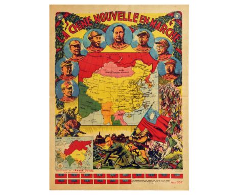
Original vintage propaganda poster featuring a map of China, titled La Chine Nouvelle en Marche - New China on the Move - issued as a supplement to l’Avant-Garde magazine. The map of China is surrounded by portraits of Chinese military leaders: Lin Piao - Nieh Yung Chen - Yen Chieh Ying - Chou Teh - Mao Tse Toung - Peng Teh Huai - Liu Pei Cheng - Ho Lung. Around the portraits are images of armed soldiers in battle, with tanks and lorries in the background - representing the end of the Chinese Civil War with one soldier stabbing a flag into the back of General Chiang Kai-shek. Across the bottom of the poster are small red rectangles which can be cut out and folded into flags to pin to the map and mark the path of the Chinese People’s Army march. Good condition, tears, fold. Country of issue: France, designer: Unknown, size (cm): 51x39, year of printing: 1949
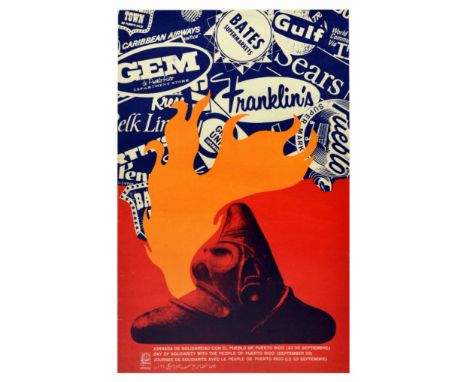
Original vintage propaganda poster issued by OSPAAAL to commemorate Day of Solidarity with the People of Puerto Rico (September 23) in their fight for independence. The poster features a stylised illustration of a fundamental symbol in the Taino religion - a three-point zemi or cemi with a fierce face of the creator god, breathing fire over different USA brands - Caribbean Airways, Bates Supermarkets, Gulf, Gem, Franklin's, Fueblo, forming the outline of the map of the USA. Text in white in Spanish, English, French, and Arabic, next to the OSPAAAL logo, over red background. OSPAAAL - Organization of Solidarity of the People of Asia, Africa & Latin America is a Cuban political movement that was founded in Havana in 1966. Good condition, creasing, tears. Country of issue: Cuba, designer: Faustino Perez, Ernesto Padron, size (cm): 53x34, year of printing: 1968
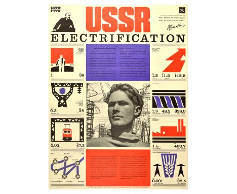
Original vintage Soviet propaganda poster celebrating USSR Electrification developments between 1870 and 1970. The poster is divided into multiple boxes containing graphics and statistics including the per capita consumption of power in industry, power consumption in agriculture and transport, and the total capacity of Soviet hydroelectric stations. Includes a map of the ‘Mir’ power grid. The design is in orange, black and purple, with a black and white photograph of a man in front of a power plant at the centre of the poster, and a drawing of Lenin in the top left corner and a quote by him in the top right corner - Only when the country has been electrified, and industry, agriculture and transport have been placed on the technical basis of modern large-scale industry, only then shall we be fully victorious. Good condition, repaired tears, creasing. Country of issue: Russia, designer: Unknown, size (cm): 89x67, year of printing: 1970
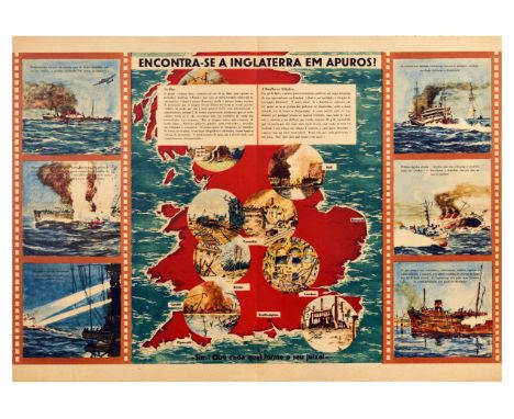
Original vintage World War Two Nazi propaganda poster issued in Portuguese titled Is England in trouble? Yea! Let each one form his judgment! featuring an article citing Sidney Sun and London Times raising concerns on the situation with the daily air attacks destroying cities and doubting the position and ability of the local authorities to take care of the urgent needs - transport, railways, roads, telegraph and telephone services, and water, gas, and electricity supply, supported with a map of England with inserts of Hull, Coventry, Bristol, Cardiff, London, Plymouth, Southampton on fire, in rubble and destruction, with caption illustrations on either side of the map depicting German bombers and submarines destroying English ships. Good condition, folds, foxing, minor tear. Country of issue: Portugal, designer: Unknown, size (cm): 42x59.5, year of printing: 1940s
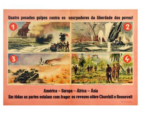
Original vintage World War Two Nazi propaganda poster issued in Potuguese titled Four heavy blows against the usurpers of peoples' freedom! America - Europe - Africa - Asia everywhere the setbacks on Churchill and Roosevelt explode with bang', featuring four illustrations with warships, boats, sailors, soldiers, bombs, missiles, planes, tanks, captioned - Bombing of North American oil refineries by German submarines. German battleships cross the English Channel ahead of Dover. Axis troops under General Rommel take Benghasi. British officers on the occasion of the surrender of Singapore to the victorious Japanese armed force; with a map of the world and text titled The theatres of the victorious dispute of the Pact of the Three Powers with the domination on Anglo-North American gold. Coup after coup against Roosevelt and Churchill. Fate is fair and marches without being held back. Horizontal. Good condition, folds, browning, double sided. Country of issue: Portugal, designer: Unknown, size (cm): 42x59, year of printing: 1942
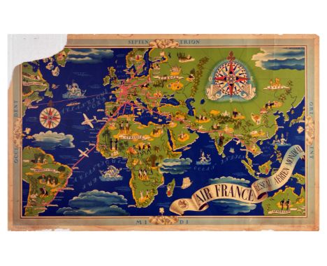
Original vintage illustrated planispere world route map issued by Air France, titled Reseau Aerien Mondial (Global Air Network), designed by Lucien Boucher. Continents and major cities are marked on the map, with travel routes from Paris shown with pink lines. Illustrations decorate the map, including men on camels, the Arc de Triomphe, temples, characters in traditional national dress, an orthodox church, ocean lines, planes, sea monsters, and skyscrapers. The map has a light blue border, with the title in black text on a white banner. Poor condition, large paper losses, tears, staining, creasing. Country of issue: France, designer: Lucien Boucher, size (cm): 64x101, year of printing: 1937
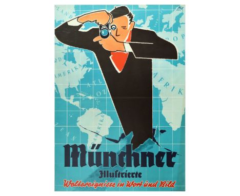
Original vintage advertising poster for the German magazine Munchner Illustrierte - Weltereignisse in Wort und Bild / World events in word and pictures - with artwork by Max Hartl. The image shows a man in a large black coat, red scarf and beret looking into a camera to take a photograph - the man is bursting up through a tear in a blue world map which forms the background of the poster. Good condition, folds, pinholes, creasing, tears, minor staining. Country of issue: Germany, designer: Max Hartl, size (cm): 119x84, year of printing: 1950s
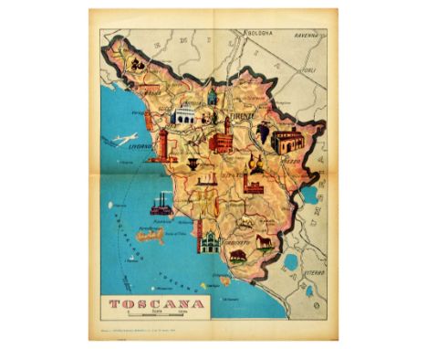
Original vintage poster featuring a map of Toscana / Tuscany in Italy. The map is illustrated with pictures of the region’s architecture, landmarks and wildlife. Tuscany is known for tourism, wine, and its history as the birthplace of the Italian Renaissance. It is home to World Heritage Sites including the Centre of Florence, the Cathedral square of Pisa, San Gimignano, and Val d’Orcia. Published by La Scuola Publishing House as part of an educational magazine for school teachers. Good condition, folds, browning, tears. Country of issue: Italy, designer: Unknown, size (cm): 57x43, year of printing: 1960
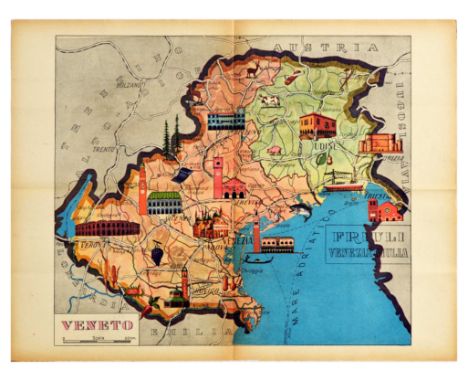
Original vintage poster featuring a map of Veneto and Friuli regions in northeast Italy. The map is illustrated with the landmarks and wildlife of the regions: Verona Arena - Basilica Palladiana in Vicenza - Loggia del Lionello in Udine - Palazzo dei Rettori in Belluno - Gorizia Castle. Published by La Scuola Publishing House as part of an educational magazine for school teachers. Good condition, folds, browning, small paper loss. Country of issue: Italy, designer: Unknown, size (cm): 43x57, year of printing: 1960s
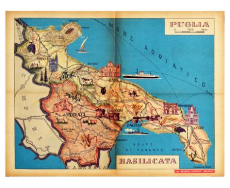
Original vintage poster featuring a map of Puglia / Apulia and Basilicata / Lucania regions in the southern peninsula section of Italy. With coastlines on the Tyrrhenian Sea and the Gulf of Taranto, Basilicata is bordered by Campania, Apulia and Calabria and is known for Pollino, Italy’s largest national park, as well as several archeological and religious sites including Heraclea, the Jewish catacombs of Venosa, Venusia, Acerenza Cathedral and Melfi Castle. Apulia borders Molise, Campania, and Basilicata and its main town is Bari. The map is illustrated with pictures of the regions’ food, wildlife and architecture including forests, grapes, pears, corn, and castle ruins. Place names are marked in black font, including Potenza - Bari - Taranto - Lecce - Brindisi - Foccia. Published by La Scuola Publishing House as part of an educational magazine for school teachers. Good condition, folds, browning, folded as issued. Country of issue: Italy, designer: Unknown, size (cm): 43x57, year of printing: 1960s
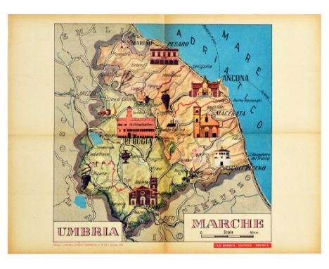
Original vintage poster featuring a map of the Umbria and Marche regions in central Italy. Bordered by Tuscany, Lazio and Marche, Umbria is a mountainous region known for being home to Lake Trasimeno, Marmore Falls, University ton Perugia, and a World Heritage Site associated with St Francis of Assisi. To the East, Marche (Le Marche / The Marches) is a hilly region on the Adriatic Sea coast; it is the birthplace of Raphael and a major centre of Renaissance history. The map is illustrated with the regions’ architecture, food and wildlife, with place names marked in black including: Perugia - Macerata - Ancona - Mare Adriatico / Adriatic Sea - Ascoli Piceno - San Marino - Pesaro. Published by La Scuola Publishing House as part of an educational magazine for school teachers. Good condition, folds, browning, small tear. Country of issue: Italy, designer: Unknown, size (cm): 43x57, year of printing: 1960s


A Kneeling Rolls-Royce 'Spirit of Ecstasy' mascot and four car badges,the pre-war chrome plated mascot signed C Sykes and dated 26.1.35, 9cm high on a wooden display base, the badges comprising: VSCC enamel badge with bar mounting bracket; Cornwall by Renamel (cracked); Great Britain and RAC plastic badges (faded and cracked); together with a Manual for Drivers in Germany, 1948; Esso War Map; The Battle of Britain HMSO booklet, first edition 1941; and a Short Guide to Great Britain by War and Navy Departments, Washington DC. (Qty)For further information on this lot please visit Bonhams.com


ENGLISH RAILWAYS CUP FINAL AT ARSENAL 1928 Joint issue programme 24/3/1928 for Barry (G.W.R.) v Gateshead (N.U.R.) N.U.R. Orphan Fund Cup and the London Combination League match v Southend United, creased. This was the first programme to be issued with the railway map on the back of the red outer cover. Generally good


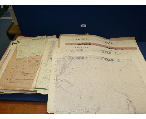
Cartography - a collection of 17th century and later maps of GB, Europe, and World, including Ireland, Gerardus Mercator (1512-1594), Irlandiae Regnum, [n.d., 1616], two-fold engraving, some colouring, 40.5cm x 52cm, (1); Christopher Saxton (c. 1540-c. 1610), Radnorshire, Wales, [London]: John Speed, [n.d.], copperplate engraving, later hand-colouring, 46cm x 52cm, (1); Emanuel Bowen (1694-1767), A New & Accurate Map of the Netherlands or Low Countries [...], No. 13, [London: 1747], two-fold, engraving, 46cm x 56.5cm, (1); Scott (R), Hydrographical Chart of the World on Wright or Mercator's Projection, [Edinburgh: 1814], two-fold hand-coloured engraving, 52cm x 71.5cm, (1); Polar, two maps: John & Charles Walker, Circumjacent of the North [&] South Pole, 19th century, 41cm x 33.5cm, (2); Robert de Vaugondy (1688-1766), [Northern Part] Royaume de Naples, Venice: 1779], copperplate engraving, delineated in colour, 51.5cm x 73cm, (1); Nicolas Bailleul le jeune (fl. 1740 - 1750), L'Italie [...], Lyon: 1762, two-fold engraving with some hand-colouring, 50cm x 70cm, (1); Pierre M. Lapie (19th century), Carte de l'Europe [&] Scandinavie, two-fold engravings, 67.5cm x 51.5cm & 51.5cm x 67.5cm, (2); Turkey, Syria, the Holy land, Italy; 17th century and later book leaves with in-text illustrations of globes, armillary spheres, cartographic and scientific instruments, (7); etc., [folio]

![Cartography, Africa - John Cary (c. 1754 ? 1835), A New Map of Egypt [...], London: 1805, two-fold engraving, contemporary ha](https://cdn.globalauctionplatform.com/d8ce81ee-3057-4298-ac18-ad6b00a5b300/536abdec-03c7-497e-86f1-ad9101418a25/468x382.jpg)
Cartography, Africa - John Cary (c. 1754 ? 1835), A New Map of Egypt [...], London: 1805, two-fold engraving, contemporary hand-colouring, 52cm x 61cm, (1); Joseph Enouy (early 19th century), Egypt with part of Arabia and Palestine [...], London: 1801, two-fold engraving, contemporary hand-colouring, 72cm x 51.5cm, (1); Antonio Zatta (fl. 1757?1797), Le Coste di Barbaria [...] Algeri, di Tunis, di Tripoli, Venice: 1794, two-fold engraving, hand-colouring, 38cm x 51cm, (1); 19th century steel engravings, sub-Saharan and Central Africa, various; etc., [14]

Cartography, Asia - Benjamin Baker (1766-1841), after William Faden (1749-1836), A Map of the Peninsula of India/ from The 19th Degree North Latitude to Cape Comorin, on two sheets, third edition, London: 1800, two-fold engraving, contemporary hand-colouring, each sheet 57cm x 84cm, (2); The Bay of Bengal, London: J.W. Norie & Co., 1831, two-fold monochrome engraving, 96.5cm x 65.5cm, (1); etc., [6]

Cartography, the Americas and the Caribbean - George Washington Boynton (American, fl. c. 1830 - 1850), map of the West Indies, Entered [...] in the Year 1838 by T.G. Bradford [...], Massachusetts, hand-coloured engraving, 40.5cm x 33.5cm, (1); Antigua, Edinburgh: Engraved by Kirkwood & Son, [n.d., c. 1820], hand-tinted engraving, laid on card, 26.5cm x 35.5cm, (1); Moll's Jamaica, restrike, (1); The Bermudas, or Summer Islands, [n.d., c. 1820], hand-tinted engraving, laid on card, 27.5cm x 30cm, (1); others, French, 18th century, various; Cuba; others, Central and South America, 19th century, including J.T. Hammond of New York (19th century), South America, hand-coloured engraving, 28.5cm x 21.5cm, mounted, (1); etc., [17]

![John Ogilby (1600 - 1676), a two page map, The Road from Nottingham to Grimsby in the Count of Lincolne (sic, Lincoln) [...],](https://cdn.globalauctionplatform.com/d8ce81ee-3057-4298-ac18-ad6b00a5b300/aff27f7d-8d22-44ac-b2db-ad910141909d/468x382.jpg)


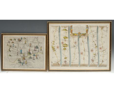
Michael Drayton (1563 - 1631) and William Hole , a two page coloured map, Derbyshire, Nottinghamshire and Leicestershire, plate 115 from Drayton's Poly-Olbion, 26.5cm x 33cm; John Ogilby (1600 - 1676), a coloured strip map. Stony Stafford to Derby, plate 40 from his Britannia Atlas of 1675, 35cm x 45cm (2)
-
109198 item(s)/page