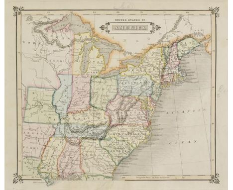

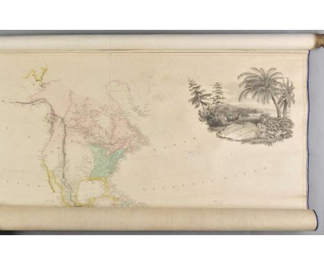
Lizars (W.H.). A Modern and Ancient General Atlas Comprehending all the Empires, Kingdoms, States &c. in the World. Constructed from the most correct Authorities and containing all the recent Discoveries of Parry, Ross, Franklin &c. &c. published Whittaker, Treacher & Co., 1831, calligraphic title with near contemporary manuscript signature partially deleted, title page detached, torn, frayed and spotted, thirty-six (complete as list) engraved maps with contemporary hand colouring, comprising of thirty-three 'modern' maps and three ancient historical maps, each map with a contemporary manuscript title on verso and pencil marginalia and occasional pencil annotations to maps, some finger and dust soiling to margins, index bound at rear, contemporary half calf, lacking upper board and spine, heavily worn and rubbed, 4to An uncommon atlas. Only two institutional copies recorded and no copy appearing in auction for thirty years. (1)
We found 109182 price guide item(s) matching your search
There are 109182 lots that match your search criteria. Subscribe now to get instant access to the full price guide service.
Click here to subscribe- List
- Grid
-
109182 item(s)/page
Greece. Jaillot (Alexis-Hubert), La Mor‚e et les Isles de Zante, Cefalonie, Ste Maure, Cerigo &c. published Paris, 1696, large engraved map of the Peloponnese after N.Sanson, contemporary outline colouring, slight creasing, 565 x 845 mm, together with, D'Anville (Jean Baptiste Bourguignon), Les C“tes de la Gr‚ce et L'Archipel, published Paris, 1756, large uncoloured engraved map, some staining, torn with slight loss to upper margin, small ink library stamp, 540 x 710 mm (2)
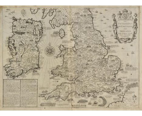
England, Wales & Ireland. Speed (John), The Invasions of England and Ireland with al their Civill Wars since the Conquest, published Roger Rea, [1662], uncoloured engraved map, engraved by Cornelius Danckerts, decorative cartouche, compass rose and numerous rhumb lines, slight fraying and dust soiling to margins, short split at base of central fold, strengthened on verso, one small hole to image, small library blind stamp in margin, 385 x 520 mm, English text on verso Shirley. Early Printed Maps of the British Isles, 1477 - 1650, no.397. (1)
Burchell (William J.). Travels in the Interior of Southern Africa, 2 vols., 1st ed., 1822-24, 20 hand-coloured aquatint and engraved plates, some folding, large engraved folding map at end of vol. I (torn without loss), illustrations, errata slip to vol. I, bound without half titles, occasional light offsetting and spotting, bookplates, contemporary half calf, spines with black labels (vol. I spine with chip and closed tear), a little rubbed and scuffed, 4to Abbey Travel 327; Mendelssohn I, p.224; Tooley 116. "The most valuable and accurate work on South Africa published up to the first quarter of the nineteenth century." (Mendelssohn). (2)

Sussex. Greenwood (C. & J.), Map of the County of Sussex from an actual Survey made in the Years 1823 & 1824..., Greenwood Pringle & Co., 1825, large uncoloured engraved map, sectionalised and laid on linen, in three sections, calligraphic title, engraved vignette of Chichester Cathedral and table of reference to the hundreds, slight staining, 1250 x 2020 mm, marbled endpapers, contained in contemporary cloth slipcase with bookplate of William Houston to upper siding, worn and frayed (1)
Albrizzi (Giovanni Battista). L'Etranger Plainement Instruit des Choses les Plus Rares et Curieuses, Anciennes et Modernes de la Ville de Venise et des Isles A l'Entour, avec la description de ses Eglises, Monasteres, Hopitaux, Tresor de S. Marc, Arsenal, & Batimens publiques: ainsi que des Tableaux les plus excellens, des Moeurs, des Arts & des Sciences, du Commerce..., 1st French edition, Venice, 1771, engraved frontispiece, folding map, and forty-one engraved plates, some folding and with two views, three(?) plates lacking, V1 with short tear in lower blank margin, a clean copy, sprinkled edges, contemporary vellum, gilt titled on spine, with some early manuscript below, 8vo According to the list of plates, there are three lacking: 11/12 - Tour de l'Horloge dans la Place/Eglise de S. Jeminien; 40/41 S. Marie de Nazeret des Carmes dechausses/S. Jeremie y joint le Palais Labia; 68/69 Isle de Burano/Isle de Mazorbo. However, only the first of these has the remains of the stub inside the volume, suggesting that the other two may never have been present in this copy. It would appear that other copies of this work also vary slightly in the number of plates. (1)

Switzerland. Wyher (Ludwig Pfyffer von), Panorama oder Zirhel-Aussicht vom Rigi Berg..., published Lucerne, 1820, engraved circular map with contemporary hand colouring, sectionalised and laid on linen, an oval vignette view to each corner, map edged in later blue tape, 530 x 530 mm, contemporary marbled card slipcase with publisher's labels to verso and recto, rubbed and worn at extremities A circular 'birds-eye' view of Mount Rigi in central Switzerland. Probably published to satisfy a demand from a newly emerging tourist and alpinist market. (1)
Hedin (Sven). Central Asia and Tibet Towards the Holy City of Lassa, 2 vols., 1st English ed., 1903, four folding maps, illustrations, scattered spotting, vol. II front hinge a little tender, top edge gilt, original red cloth gilt, spines and extremities faded, a few light stains, 8vo, together with Stanley (Henry M.), In Darkest Africa or the Quest, Rescue and Retreat of Emin Governor of Equatoria, 2 vols., 1st ed., 1890, four folding maps (vol. I map detached and torn in two without loss), illustrations, some spotting, original red pictorial cloth gilt, a few dampstains, 8vo, with others including J.G. Millais' Newfoundland and its Untrodden Ways, 1907 and Wanderings and Memories, 1919 (13)
![Le Vaillant (Francois). Second Voyage dans l'Int‚rieur de l'Afrique..., 2 volumes, Paris: Jansen, [1796], half-titles, twenty](https://cdn.globalauctionplatform.com/c12840a3-3b4d-4fdb-b160-a59100af72af/78b62d04-5bf7-4558-d309-beb443ad14a8/468x382.jpg)
Le Vaillant (Francois). Second Voyage dans l'Int‚rieur de l'Afrique..., 2 volumes, Paris: Jansen, [1796], half-titles, twenty-one engraved plates (including five folding), all with contemporary hand-colouring, most with original guard sheet, occasional minor mark, partially removed library ink stamps to half-titles and titles, contemporary marbled calf, gilt, spines later varnished, rubbed and scuffed to joints and corners, shelf mark to foot of spines (removed), 4to No precedence has been established between the present work (being the publisher's deluxe 4to) and the 8vo edition issued in three volumes. A folding map was issued separately at a later date. (2)
Howitt (Alfred William). The Native Tribes of South-East Australia, 1st edition, 1904, 9 folding coloured maps (as called for, one detached), one table, illustrations to text, errata slip bound in, occasional spotting, original cloth gilt, a little rubbed and slightly darkened on spine, together with Spencer (Walter Baldwin), The Native Tribes of the Northern Territory of Australia, 1st edition, 1914, photographic plates, folding coloured map, illustrations to text, publisher's advert leaf at rear, hinges slightly cracked, original cloth gilt, rubbed and spine slightly faded, plus The Northern Tribes of Central Australia, 1st edition, 1904, folding map, two colour folding plates and two folding tables, black and white illustrations to text, some heavy spotting, bookplate removed from front pastedown, hinges cracked, original cloth gilt, some fraying and wear, spine faded, plus Frazer (James George), The Belief in Immortality and the Worship of the Dead, 3 volumes, 1st editions (volume 1 2nd impression, volumes 2 & 3 1st impression), 1913-22-24, uncut and largely unopened, original cloth gilt, a little rubbed and minor fraying at foot of volume 2, all 8vo (6)
Stuart (John McDouall). Explorations in Australia. The Journals of John McDouall Stuart During the Years 1858, 1859, 1860, 1861, & 1862, when he Fixed the Centre of the Continent and Successfully Crossed it from Sea to Sea, ed. William Hardman, 1st ed., 1864, half title, mounted oval albumen portrait frontispiece, sketch map, folding engraved map (with repaired tear), 12 wood-engraved illustrations, scattered spotting, hinges reinforced, contemporary calf, neat reback, edges rubbed, 8vo Ferguson 16381. (1)
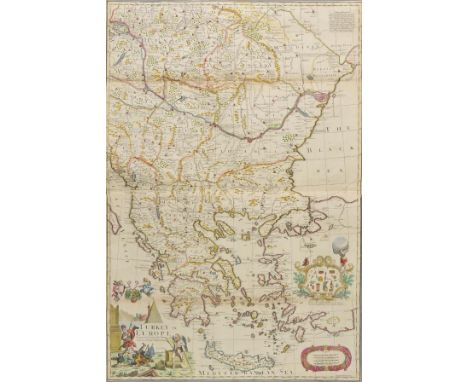
Greece, Turkey & Eastern Europe. Bowen (Emanuel), Turkey in Europe Corrected from the Newest and most Exact Observations, made and sold by G.Willdey, 1715, large engraved map on two conjoined sheets, contemporary outline colouring, decorative cartouche and mileage scale and an inset cartouche advertising items sold in George Willdey's shop, one small repaired marginal closed tear, old folds, slight browning to one fold, thread margins, 925 x 630 mm (1)
Crimean War. Elphinstone (Capt. R.E.), Plan of the Seige of Sevastopol by the Allied Armies in 1854 - 5, published The War Department, circa 1858, folding lithographic map, 650 x 980 mm, together with another eleven (only) folding lithographic maps (including one coloured) showing plans of trenches, batteries, troop positions, redoubts and earth works of British and Russian forces during this period of the Crimean War, various sizes and condition, contained in a later cloth book box, broken and damaged, together with, Forsell (Carl Gustaf A.F.), Karta ”fver S”dra Delen af Sverige och Norrige eller det fordna s† kallade Skandinavien p† hans Majt. Konungens allern†digste befallning..., published Stockholm 1815-1826, large engraved map sectionalised and laid on linen on four sheets (only of eight), each sheet approximately 590 x 820 mm, contained in contemporary marbled card slip case, rubbed and worn at extremities (13)
Lewis (Hardwicke). An Excursion to Margate in the Month of June, 1786, interspersed with a Variety of Anecdotes of well-known Characters, third edition, J. French, 1787, engraved double-page map frontispiece, half-title, publisher's advert to verso of half title, occasional slight spotting, bookplate of Charles Parr Burney to front pastedown, contemporary half calf, rubbed and worn, upper board loose, small 8vo Charles Parr Burney (1785-1864) was the nephew of the authoress Fanny Burney, and the grandson of the composer and music historian Charles Burney. (1)

Spain & Portugal. Moll (Herman), A New and Exact Map of Spain & Portugal Divided into its Kingdoms and Principalities &c..., published D.Midwinter, P.Overton and T.Bowles, 1711, engraved map with contemporary outline colouring, large uncoloured cartouche, slight creasing, old folds, one long closed repaired tear affecting image, some fraying with slight loss to one old fold, slight browning to central fold, 610 x 980 mm, together with, A New Map of Italy Distinguishing all the Sovereignties in it, whether States, Kingdoms, Dutchies, Principalities, Republicks &c..., published D.Midwinter, T.Bowles and Philip Overton, circa 1720, engraved map on two conjoined sheets with contemporary hand colouring, three inset views of Mount Etna, Mount Vesuvius and Mount Aeolius, some creasing, old folds, some fraying and browning to old folds with slight loss, slight staining, repaired closed tears, 605 x 980 mm, with, The Turkish Empire in Europe, Asia and Africa..., published D.Midwinter & T.Bowles, circa 1720, engraved map on two conjoined sheets, contemporary hand colouring, inset views of Constantinople and Smirna, three views of the Holy Sepulchre and a panorama of Jerusalem, slight creasing, some splits along old folds, slight fraying to margins, one long, closed repaired tear affecting image, slight fraying to margins, 615 x 1010 mm, with one other similar (4)
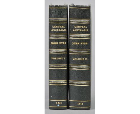
Eyre (Edward John). Journals of Expeditions of Discovery into Central Australia, and Overland from Adelaide to King George's Sound, in the Years 1840-1; Sent by the Colonists of South Australia, with the Sanction and Support of the Government: Including an Account of the Manners and Customs of the Aborigines and the State of their Relations with Europeans, 2 vols., 1st ed., 1845, 22 engraved and lithographed plates, one folding colour map by Arrowsmith at end of vol. II only (of two, repaired to verso), bound without advertisements, p. 143 in vol. II lower corner torn away, circular library inkstamps, some light spotting and offsetting, modern green half morocco, 8vo Ferguson 4031: "This account of Eyre's explorations contains also much valuable information about the aborigines." (2)
Gruisen (N.L. van). A Holiday in Iceland, 1st ed., 1879, five mounted photographs, a few light thumbmarks, endpapers a little toned, original cloth, a little rubbed, 8vo, together with Shepherd (C.W.), The North-West Peninsula of Iceland. Being the Journal of a Tour in Iceland in the Spring and Summer of 1862, 1st ed., 1867, folding map, two colour plates, a few spots, original green cloth, spine a little darkened, 8vo, plus Visit to Iceland and the Scandinavian North. Translated from the German of Madame Ida Pfeiffer, 1st English ed., 1852, additional tinted title and seven tinted plates, scattered spotting, original green cloth, spine a little faded, 8vo, with others related including Pliny Miles' Nordurfari or Rambles in Iceland, 1854, Charles Forbes' Iceland; Its Volcanoes, Geysers and Glaciers, 1860 and Sabine Baring-Gould's Iceland: Its Scenes and Sagas, 1863 (23)
Belgium & Holland. Senex (John), The VII United Provinces Corrected from the Observations communicated to the Royal Society at London and ye Royal Academy at Paris, 1709, engraved map with contemporary outline colouring, old folds strengthened and repaired on verso, 645 x 935, together with, Mercator (Gerard & Hondius J.), Leodiensis Dioecesis Typus, circa 1605, engraved map with contemporary hand colouring, vertical margins partially strengthened on verso, 335 x 485 mm, Latin text on verso, with, Laurie (Robert & Whittle James), A New Map of the Seat of the War in the Netherlands from the best Authorities, 1794, hand coloured engraved map, 490 x 655 mm, plus, Homann (Johann Baptist), Arena Martis in Belgio qua Provinciae X Catholicae Inferioris Germaniae..., published Nuremberg, circa 1730, engraved map with contemporary outline colouring, central fold partially strengthened on verso 490 x 565 mm, with another three maps similar including examples by Sanson, Homann's heirs and Coronelli, various sizes and condition (7)
Davis (John). Tracks of McKinlay and Party Across Australia. Edited from Mr. Davis's Manuscript Journal; with an Introductory View of the Recent Australian Explorations of the McDougall Stuart, Burke and Willis, Landsborough, etc., by William Westgarth, 1st ed., 1863, half title, folding map (repaired), 14 tinted lithographed plates (one or two margins a little frayed), a few light spots, later half calf, spine faded, label renewed, 8vo Ferguson 9005. (1)
Cary (John). Cary's New Itinerary: or an Accurate Delineation of the Great Roads, both Direct and Cross throughout England and Wales, 7th edition, 1817, five folding engraved maps at rear (one creased and slightly edge-frayed), lacking two maps, including the large map of England & Wales, extra-illustrated with five folding engraved ribbon maps, engraved title-page and dedication leaf, 4pp. publisher's advertisements, generally toned, modern half calf gilt, 8vo in 4s, together with Hazlitt (William), A View of the English Stage; or, A Series of Dramatic Criticisms, 1st edition, 1818, preliminary blank leaves water-stained, marbled endpapers, hinges repaired, bookplate (designed by Keith Vaughan) of actor and director Michael Redgrave on front pastedown, contemporary sprinkled calf, somewhat stained and rubbed, rebacked, 8vo in 4s, plus Black (Adam and Charles), New Zealand, Painted by F. and W. Wright, Described by Hon. William Pember Reeves, 1st edition, 1908, numerous colour plates, folding map and publisher's advertisement leaf at rear, faint contemporary inscription to preliminary blank, hinges split, edges spotted, original decorative brown cloth, some minor rubbing to extremities, 4to, plus forty-nine others leather-bound, mostly 19th century, some odd volumes and incomplete sets (52)
Radnorshire. Speed (John), The Countie of Radnor Described and the Shyretownes sittuatione, published Roger Rea, [1662], uncoloured engraved map, strapwork cartouche, mileage scale and compass rose, inset town plan of Radnor, slight creasing, small library blindstamp to margin, 385 x 510 mm, English text on verso (1)
Sturt (Captain Charles). Narrative of an Expedition into Central Australia, Performed under the Authority of Her Majesty's Government, During the Years 1844, 5, and 6. Together with a Notice of the Province of South Australia in 1847, 2 vols., 1st ed., 1849, folding map with outline colour, 20 plates (including 4 colour lithographed plates after John Gould), a few plates trimmed affecting imprint, bound without the advertisements, some light offsetting, spotting and waterstains, contemporary burgundy half morocco, spines faded with a few spots, 8vo Ferguson 5202. Sturt's final expedition into the heart of the continent, where he confirmed the non-existence of an inland sea and discovered Cooper's Creek, the Stony Desert and the Simpson Desert. (2)
Tully (Miss.). Letters Written during a Ten Years' Residence at the Court of Tripoli; Published from the Originals in the Possession of the Family of the Late Richard Tully..., comprising Authentic Memoirs and Anecdotes of the Reigning Bashaw..., also, an Account of the Domestic Manners of the Moors, Arabs and Turks, 2 vols., 3rd edition, 1819, seven hand-coloured aquatint plates and one folding engraved map, some offsetting to text, recent endpapers, contemporary half calf, rebacked retaining morocco title labels, 8vo Abbey Travel 299. (2)

Mediterranean. Sanson (Nicolas), A New Mapp of the Mediterranean Sea Divided into its Principal Parts or Seas..., Rendered into English, Printed and Sold by Hen; Overton..., circa 1680, engraved map with contemporary outline colouring, on two conjoined sheets, slight oxidisation to old watercolour causing slight cracking and splitting, repaired on verso, 485 x 840 mm Uncommon. (1)
Boron (Vittorio, illustrator). Malta, by Frederick W. Ryan, 1st edition, 1910, 20 colour illustrations, plus folding map to rear, bookplate to front pastedown, inscription to title page, some light spotting, original gilt decorated green cloth, 4to, together with Summerville (Frankfort), The Spirit of Paris, 1st edition, 1913, 20 colour illustrations, inscription to front endpaper, original gilt decorated brown cloth, 4to, and Compton (E. Harrison), The Dolomites, King Laurin's Garden by Reginald Farrer, 1st edition, 1913, 20 colour illustrations plus folding map to rear, some minor spotting, original gilt decorated blue cloth, spine slightly rubbed to head and foot, 4to, plus 29 further A&C Black publications, including The Cape Peninsular by W. Westhofen, 1st edition, 1910, Nuremburg by Mrs Bell, 1905, all original cloth, G/VG, 8vo/4to (33)
![Ireland. Speed (John), The Province of Mounster, published Roger Rea, [1662], uncoloured engraved map, inset town plans of Li](https://cdn.globalauctionplatform.com/c12840a3-3b4d-4fdb-b160-a59100af72af/4bda79e1-1b62-4000-9570-d4294404d57f/468x382.jpg)
![Bible [English]. [The Holy Bible, Conteyning the Old Testament, and the New: Newly Translated out of the Originall Tongues an](https://cdn.globalauctionplatform.com/c12840a3-3b4d-4fdb-b160-a59100af72af/52434a45-a3e9-406a-90db-e04c9f2640b3/468x382.jpg)
Bible [English]. [The Holy Bible, Conteyning the Old Testament, and the New: Newly Translated out of the Originall Tongues and with the former Translations diligently compared and revised, by his Maiesties speciall Commandement. Appointed to be read in Churches. Imprinted at London by Robert Barker, 1613,11], Old Testament & Apocrypha portions only (ending at II Maccabees chapter 15, verse 39), lacking general title, double column black letter text, with 59 lines to full column, numerous woodcut decorative intials, ten preliminary leaves only of 18 (comprising Kalendar, lessons for Holy days & list of Books), first leaf of Genesis repaired to margins, bound with Genealogies by John Speed before book of Genesis with woodcut of Adam & Eve (without map), first and last few leaves frayed to margins, initial leaves creased, some dampstaining etc. mostly to leaves at front & rear, large decorative ownership inscription to front blank 'Simon Ruddle his book, given him by his Grandmother Ruddle 1764' and other 18th & 19th century entries to front endpaper (one blank detached), sewing a little weak and some gatherings sprung, late 17th/early 18th century panelled sheep, some wear, folio, leaf size 39 x 26cm Herbert 319, Darlow & Moule 246. Commonly known as the 'Great She Bible' with Ruth iii.15 'she went into the city'. (1)
Americas. Arrowsmith (Aaron), Map of America, 1804, large engraved wall map with contemporary outline colouring, on four conjoined sheets and laid on linen, stained and spotted at base, lower margin a little frayed with slight loss, mounted on a near contemporary 'spring loaded' roller, 1190 x 1450 mm (1)
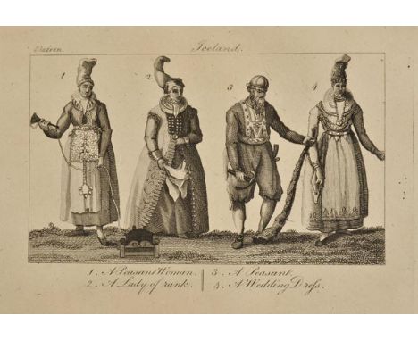
Olafsson (Eggert & Bjarni Palsson). Travels in Iceland: Performed by Order of his Danish Majesty. Containing Observations on the Manners and Customs of the Inhabitants, a Description of the Lakes, Rivers, Glaciers, Hot-Springs, and Volcanoes; of the Various Kinds of Earths, Stones, Fossils and Petrifications; as well as of the Animals, Insects, Fishes &c. Translated from the Danish, 1st English ed., 1805, folding engraved map, six engraved plates including a duplicate plate of Mount Heela and a hand-coloured Birds Eye View of a Volcano in the Island of Bourbon (taken from Bory de St. Vincent's work on Mauritius and the Isle of Bourbon), a few light spots, bookplates and presentation inscription, all edges gilt, later reverse calf, covers with armorial crest stamped in gilt, spine with green labels, some slight fading to margins, 8vo (1)
Ogle (Nathaniel). The Colony of Western Australia: A Manual for Emigrants to that Settlement or its Dependencies: Comprising its Discovery, Settlement, Aborigines, Land-Regulations, Principles of Colonial Emigration; Statistical, Financial, and Agricultural Reports; Also Instructions and Hints to Settlers..., with an Appendix, 1st ed., 1839, folding linen-backed colour map by Arrowsmith (close-trimmed with stains), four outline plates (two folding), four folding tables, lacking last Appendix leaf? (last leaf paginated xvi), blindstamps (including Parliament of Victoria), some spotting and toning, later tan half calf, a little rubbed and faded, 8vo, inscribed by the author to Thomas George Margary to title (trimmed at head), dated 1839, 8vo, together with Stoney (Captain H. Butler), Victoria: with a Description of its Principal Cities Melbourne and Geelong: And Remarks on the Present State of the Colony: Including and Account of the Ballaarat Disturbances, and of the Death of Captain Wise, 40th Regiment, 1st ed., 1856, folding map, wood-engraved illustrations, publisher's catalogue at end, a few spots. closed tear to half title, contemporary presentation inscription, original cloth, morocco reback, marginal fading, 8vo Ferguson 2819 & 16296 respectively. (2)

West Indies. Moll (Herman), A Map of the West-Indies or the Islands of America in the North Sea with ye adjacent Coutries, explaining what belongs to Spain, England, France, Holland &c. also ye Trade Winds and ye Several Tracts made by ye Galeons and Flota from Place to Place, circa 1730, large engraved map on two conjoined sheets, contemporary hand colouring, inset maps of St. Augustine, Havana, Cartagena, Porto Bello and Vera Cruz, inset view of Mexico City, old folds, slight creasing, old folds strengthened on verso, slight browning to one fold, 590 x 1010 mm (1)
Fashion & Costume. La Belle Assemblee, being Bell's Court and Fashionable Magazine, 6 odd volumes, 1810-21, folding map, ninety-eight engraved plates (including some folding), fifty-four coloured fashion plates, small holes where previously sewn, contemporary half calf, rubbed and worn, boards detached, 8vo, together with a volume of plates from the West End Gazette Sold as a collection of plates, not subject to return. (7)
Merioneth. Speed (John), Merionethshire Described, published Roger Rea, [1662], uncoloured engraved map, inset view of Harlech, some creasing, library blind stamp to margin, slight staining, 385 x 505 mm, English text on verso, together with, Denbighshire, published Roger Rea, [1662], uncoloured engraved map, some creasing, small library blind stamp to margin, slight staining, 385 x 505 mm, English text on verso, with, Flint-Shire, published Roger Rea, [1662], uncoloured engraved map, inset town plans of Flint and St. Asaph, some creasing, torn with slight loss at base of central fold, repaired on verso, marginal repaired closed tears, two small holes to image, 390 x 515 mm, English text on verso (3)

British Isles. Speed (John), The Kingdome of Great Britaine and Ireland, 1st edition, published John Sudbury & George Humble, [1611], hand coloured engraved map, inset views of London and Edinburgh, thread margins, two margins strengthened on verso, central fold split, repaired and strengthened on verso, occasional marginal closed tears, slight creasing, 385 x 515 mm, English text on verso R.W.Shirley. Early Printed Maps of the British Isles 1477 -1650, no.316. (1)

Vancouver (George). A Voyage of Discovery to the North Pacific Ocean, and Round the World: in which the Coast of North-West America has been carefully Examined and Accurately Surveyed. Undertaken by His Majesty's Command, Principally with a view to Ascertain the Existence of any Navigable Communication between the North Pacific and North Atlantic Oceans; and Performed in the Years 1790, 1791, 1792, 1793, 1794, and 1795, in the Discovery Sloop of War, and Armed Tender Chatham, Under the Command of Captain George Vancouver, 3 vols., 1st edition, London: G.G. & J. Robinson and J. Edwards, 1798, seventeen engraved plates after W. Alexander by J. Landseer, J. Fittler and others, and one single-page engraved map of Hergest's Islands, upper blank margin of titles with ownership signature William FitzRoy Decr. 1799 in pencil (overwritten in ink to vol. 1), with occasional pencil annotations to margins in the same hand, occasional scattered spotting and marks, some dampstaining mostly to margins of few leaves & plates, bookplates removed, 19th century half calf, gilt and blind decorated spines with morocco labels, extremities slightly rubbed, 4to Howes V-23, Sabin 98443, Hill 1753. George Vancouver (1757-1798) who had travelled with Cook on his second and third voyages, commanded HMS Discovery on the expedition to secure lands for Britain in the Pacific Northwest. He was also charged to explore the coastline between 30 and 60 degrees latitude with the intention of discovering the Northwest Passage connecting the Pacific and Atlantic Oceans. The expedition commenced in England, proceeding around the Cape of Good Hope, continuing to New Zealand, King George's Sound (discovered and named by Vancouver), Tahiti, the Hawaiian Islands, San Diego, Monterey, and San Francisco etc., progressing up the Northwest coast to Nootka Sound and Vancouver island which was named after him. Rear Admiral Lord William FitzRoy KCB (1782-1857), was the third son of Augustus FitzRoy, 3rd Duke of Grafton. He entered the Navy on 21 April 1794 and was later promoted to post-captain in 1804, taking command of the frigate Aeolus. He was present at the battle of Cape Ortegal on 4 November 1805, and at the invasion of Martinique in February 1809. In June 1810 he commissioned the frigate Macedonian to serve on the Lisbon station. On 7 April 1811 FitzRoy was dismissed from the Navy after a court-martial found him guilty of "False Expense of Stores" and "Tyranny & Oppression". FitzRoy was charged with falsifying the ship store report and selling the surplus for personal profit. He had sentenced a seaman to 48 lashes for drunkenness, four times the legal maximum. FitzRoy was declared incapable of serving again as an officer, but his former rank was restored to him by the Prince Regent the following August. He received the promotion of rear admiral in 1837, but received no further employment in the Navy. In addition to his career in the Navy he was elected Member of Parliament for Thetford in 1806, but did not actually sit in Parliament until 1810. (3)
Ballore (D. de Montessus). Les Tremblements de Terre, Geographie Seismologique, Paris: Armand Colin, 1906, three folding plates, black and white illustrations to text, library ink stamps to title, contemporary half morocco, rubbed and worn with slight loss to spine, 8vo, together with Funk (Franz Ernst Theodor), Versuch einer aug Theorie und Erfahrung gegrundeten Darstellung der wichtigsten Lehren der Hydrotechnik, Berlin: August Petsch, 1820, folding map, slight scattered spotting, ownership inscription in red ink to title, contemporary paper-covered boards, 4to, plus other seismology titles, mainly French and German (9)
Milne (John and Burton, W.K.). The Great Earthquake in Japan, 1891, plates by Kazumasa Ogawa, 1st ed., Yokahama, [1891], twenty-nine photogravure plates (22.5 x 28 cm) and line map, scattered minor marginal spotting, original cloth gilt, a little rubbed with little loss to foot of spine, oblong folio (1)
Stephens (John L.). Incidents of Travel In Central America, Chiapas, and Yucatan, volumes 1 & 2, 1841, numerous black and white engravings, black and white folding map to volume 1, map torn along folds and repaired with tape, bookplate to front pastedown of volume 1, some light spotting throughout, uniform contemporary gilt-decorated cloth, spines faded and rubbed to head and foot, 8vo, Incidents of Travel In Yucatan, volume 2 only, 1843, numerous black and white illustrations including folding frontispiece, light spotting throughout, contemporary gilt-decorated cloth, spine slightly faded and rubbed, 8vo, together with Wiggins (Ira L. & Thomas, John Hunter), A Flora of the Alaskan Arctic Slope, 1st edition, Canada, 1962, colour frontispiece, stamp and bookplate to front endpapers, original blue cloth in price-clipped dust jacket, covers slightly rubbed with minor loss to head and foot, 8vo, and other 20th-century South American and North American botanical and travel reference, mostly hardback publications, many original cloth in dust jackets, G/VG, 8vo/4to (3 shelves)

Labillardiere (Jacques Julien Houten de). Voyage in Search of La Perouse, Performed by Order of the Constituent Assembly, During the Years 1791, 1792, 1793, and 1794, Translated from the French, 1st ed., 1800, folding map, 45 engraved plates, advertisement leaf at end, some offsetting and scattered spotting, later brown half morocco, 4to Ferguson 309. Account of the search for the La Perouse expedition, by two French ships in 1791, which sailed via the Cape of Good Hope to Tasmania, then on to New Caledonia, the Solomon Islands, the Admiralty Islands, Tonga, New Britain, New Zealand and southwest coast of Australia, making new discoveries. (1)
Helps (Arthur). The Spanish Conquest in America and its Relation to the History of Slavery and to the Government of Colonies, 5 vols., 1st ed., 1855-61, half titles to vols. I-II & IV only, two folding maps, maps in text, some light spotting and toning, previous owner stamp, bookplates, contemporary mottled calf, covers stamped with gilt arms, spines with red and green labels and gilt decoration, a little rubbed and scuffed, 8vo, together with Squier (E. George), Peru. Incidents of Travel and Exploration in the Land of the Incas, 1st ed., 1877, half title, folding map, illustrations, a few spots, t.e.g., modern black half calf, Mudie's Select Library label to upper cover, 8vo, with others leather bound, including Edward Whymper's Travels Amongst the Great Andse of the Equator, 2nd ed., 1892 and William H. Prescott's History of the Conquest of Peru/Conquest of Mexico, new eds., 1878 (10)
England & Wales. Visscher (Nicolas), A New Mapp of the Kingdome of England, Representing the Princedome of Wales and other Provinces, Cities, Market Towns, with the Roads from Town to Town and the Number of Reputed Miles between them, are given by Inspection without Scale or Compass, published John Overton, circa 1694, engraved map with contemporary outline colouring, large decorative cartouche, 575 x 500 mm, together with, Angliae Regnum Tam in Septem Antiqua Anglo-Saxonum Regna quam in omnes Hodiernas Regiones accuratissime distinctum..., circa 1690, engraved map with contemporary hand colouring, large decorative cartouche, slight worming to central fold, skillfully repaired on verso, 565 x 495 mm, with, Schenk (Peiter), Novissima prae caeteris aliis accuratissima Regnorum Angliae Scotiae Hiberniae..., published Amsterdam, circa 1706, engraved map with contemporary hand colouring, inset map of the Shetland, Orkney and Faroe islands. decorative cartouche with later hand colouring, one small hole to image, 575 x 490 mm R.W.Shirley. Printed Maps of the British Isles 1650 - 1750. Visscher 2 state 4. Visscher 3. unrecorded state with a dedication to George III and Schenk 1. state 2. (3)
Henderson (Ebenezer). Iceland; or the Journal of a Residence in that Island, During the Years 1814 and 1815. Containing Observations on the Natural Phenomena, History, Literature and Antiquities of the Island; and the Religion, Character, Manners, and Customs of its Inhabitants, 2 vols., 1st ed., 1818, folding engraved map (torn in half), 16 engraved plates, occasional spotting and waterstains, modern speckled calf, 8vo (2)
![Spain. Jansson (Jan, Mercator Gerard & Hondius Henricus), Andaluzia continens Sevillam et Cordubam, [1636], engraved map with](https://cdn.globalauctionplatform.com/c12840a3-3b4d-4fdb-b160-a59100af72af/9ca94231-6261-46d4-9a8f-6c8dbee11a5c/468x382.jpg)
Spain. Jansson (Jan, Mercator Gerard & Hondius Henricus), Andaluzia continens Sevillam et Cordubam, [1636], engraved map with contemporary outline colouring, slight soiling to margins, 355 x 500 mm, English text on verso, together with, Blaeu (Johannes), Navarra Regnum, published Amsterdam, circa 1650, engraved map with contemporary hand colouring, some oxidisation to old watercolour, 420 x 500 mm, no text on verso, with, Jansson (Jan), Valentia Regnum Cotestani. Ptol. Edentani. Plin. circa 1650, engraved map with contemporary hand colouring, some oxidisation to old watercolour causing slight cracking and splitting to cartouche, 350 x 475 mm, no text on verso, plus, Blaeu (Johannes), Biscaia Alava et Guipuscoa Cantabriae Veteris partes, circa 1650, engraved map with contemporary hand colouring, heightened with gold, slight creasing, 385 x 495 mm, no text on verso (4)

*Ogilby (John). The Road from Bristol co. Glouc. to Banbury co. Oxo., circa 1680, hand coloured strip road map, a little toned, 330 x 445 mm, mounted, framed and glazed, together with, Bayly (J.), Gloucestreshire Accurately laid down in the Year 1779, hand coloured engraved map, inset vignette of The Cotham Stone, old folds, 380 x 335 mm, mounted, framed and glazed, with Rhodes (Marion, 1907-1988), Bibury, 1937, etching of Arlington Row in the Cotswold village of Bibury, captioned & signed in pencil to lower margin, plate size 17.5 x 22.3cm (7 x 8.75ins), sheet size 22.5 x 27cm (8.75 x 10.5ins), together with Rome, 1937,etching of the obelisk at Piazza del Popolo with St. Peter's Basilica in the distance, captioned, signed & dated in pencil to lower margin, plate size 21.3 x 15cm (6 x 8.25ins), sheet size 26.5 x 19.5cm (10.5 x 7.75ins), plus an etched view by Rhodes of a woodland in Buckinghamshire, plus Bolton Abbey, Wharfedale, North Yorkshire, original pen, ink & watercolour on wove (laid on card), captioned and signed to lower margin, 25.2 x 35.3cm (10 x 14ins) (6)
Halle (Clifford). To Menelek In A Motor-Car, 1st edition, 1913, 72 black and white illustrations including frontispiece, black and white map by B. Bentley, inscription and stamps to front endpapers and title-page, some light toning, original blue cloth, 8vo, together with Reeve (Henry Fenwick), The Gambia, Its History Ancient, Mediaeval, and Modern... , 1st edition, 1912, 63 black and white illustrations including frontispiece, 3 black and white maps, partially removed bookplate to front pastedown, some light spotting, original gilt-decorated maroon cloth, boards slightly rubbed, spine rubbed with minor loss to head, 8vo, and Bartlett (E.J.), In The Land of Sheba, 1st edition, 1934, 31 black and white illustrations including 2 maps, inscription to front endpaper, some minor spotting, original red cloth in dust jacket, covers slightly faded and rubbed with loss to foot of the front cover, 8vo, plus other 20th-century African travel and botanical reference, mostly hardback publications, many original cloth in dust jackets, some odd volumes, G/VG, 8vo/4to (3 shelves)


A Collection of Railway Prints: including Cuneo 'Queen of the Belgians at New Street', 27"x21", David Shepherd's 'East Somerset Railway', three Carriage-style prints, a HR 'Skye Bogie' blueprint, Tuck's Map and Compendium of the Railways of Great Britain (OPC reprint) and one other, overall G-VG


South America. Moll (Herman), To the Right Honourable Charles Earl of Sunderland and Baron Spencer of Wormleighton, One of Her Majesty's Principal Secretaries of State &c. This Map of South America..., published D.Midwinter, T.Bowles and Philip Overton, circa 1720, engraved map on two conjoined sheets, contemporary hand colouring, inset view of Potosi, old folds with some browning to folds, slight creasing, 590 x 965 mm, together with, A New & Exact Map of the Electorate of Brunswick-Lunenburg and ye rest of ye Kings Dominions in Germany..., published Philip Overton, circa 1710, engraved map on two conjoined sheets with contemporary hand colouring, two inset maps of the North Sea and The Duchy of Lauwenburg, old folds, slight creasing, slight fraying to margins, 625 x 1010 mm, with, Les Provinces des Pays-Bas Catholiques ou A Most Exact Map of Flanders or Austrian Netherlands &c., circa 1720, hand coloured engraved map on two conjoined sheets, inset maps of Luxembourg, Northern France and a plan of fortifications, old folds, 605 x 980 mm (3)
Mitchell (Thomas Livingstone). Three Expeditions into the Interior of Eatern Australia; with Descriptions of the Recently Explored Region of Australia Felix, and of the Present Colony of New South Wales, 2 vols., 2nd ed. carefully revised, 1839, title with wood-engraved vignettes, 50 lithographed plates and charts, including seven coloured (one or two close-trimmed affecting imprint), large folding map (neat repairs), single-page colour map, a few minor spots, blindstamps to titles, modern olive half sprinkled calf, spines with red labels, slightly faded, 8vo Ferguson 2811. Account of Surveyor-General Mitchell's three expeditions to determine the courses of the large rivers in Southern Australia and is of ethnographic value with its detailed descriptions of Aboriginal life, as well as geology, topography and natural history. (2)
Hawkesworth (John, ed.). An Account of the Voyages Undertaken by the Order of His Present Majesty for Making Discoveries in the Southern Hemisphere. And Successively Performed by Commodore Byron, Captain Wallis, Captain Carteret, and Captain Cook, 4 vols., 3rd ed., 1785, two folding engraved maps (first map loose), nine folding engraved plates, some scattered spotting and few minor marks, library inkstamps to initial blank and verso of titles, contemporary calf rubbed and worn, rebacked, one or two boards detached, 8vo (4)

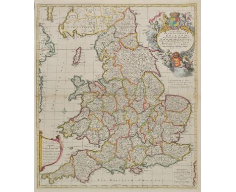
Greenwood (C. & J., publishers). Atlas of the Counties of England from Actual Surveys made from the Years 1817 to 1833, published 1834, calligraphic title with hand coloured map of England & Wales, forty-six (complete) engraved maps with contemporary hand colouring, map of Berkshire with repaired closed tear, maps of Lancashire and Lincolnshire with slight fraying to lower margins, very slight dust soiling, lacking half of marbled front endpaper, contemporary half morocco gilt with morocco label to upper siding, worn at extremities, large oblong folio Chubb CCCCLVIII (b). A good example with unfolded maps in bright condition. (1)

London. Fraser (James), Fraser's Panoramic Plan of London, published James Fraser, 1831, engraved map by James Neele, sectionalised and laid on linen with contemporary outline colouring, eighteen uncoloured vignette views to margins, slight dust soiling, 405 x 560 mm, Estate agents advertisement and map to front pastedown, contemporary cloth boards with printed label to upper siding Howgego 332. State 2. (1)
Worcestershire & Warwickshire. Blaeu (Johannes), Wigorniensis Comitatus et Comitatus Warwicensis nec non Coventrae Libertas. Worcester, Warwick Shire and the Liberty of Coventre, published Amsterdam, circa 1648, engraved map with contemporary hand colouring, slight spotting, confined to margins, 415 x 500 mm, Dutch text on verso (1)
![Ireland. Speed (John), The Province Ulster described, published Roger Rea, [1662], uncoloured engraved map, inset view of Eni](https://cdn.globalauctionplatform.com/c12840a3-3b4d-4fdb-b160-a59100af72af/b2446543-e95d-41e5-d16c-b29a13c8a568/468x382.jpg)
Priestley (Joseph). A Harmony of the Evangelists in English with Critical Dissertations an Occasional Paraphrase and notes for the Use of the Unlearned, J. Johnson, 1780, folding engraved map, scattered spotting throughout, bookplate of Foster L. Coore to upper pastedown, contemporary marbled calf, rubbed and worn, boards detached, 4to (1)
-
109182 item(s)/page