We found 109182 price guide item(s) matching your search
There are 109182 lots that match your search criteria. Subscribe now to get instant access to the full price guide service.
Click here to subscribe- List
- Grid
-
109182 item(s)/page


Lot 909
A collection of Ephemera of Military Interest includes framed 8 silk Victorian Cross Winners, real photo postcards of Drumhead Court Martial, 6 prints of Military Aircraft, framed copy of General Washington Call to Arms poster, black & white print of Balaclava The Return 25th October 1854 (the charge of the six hundred) map Scotland of Old, Lands, Arms & Crests


Lot 1860
Souvenir folder of 6 prints by Rex Whistler (1905-1944) for Rothmans Diamond Jubilee 1890- 1950, celebrating makers of fine cigarettes through the six reigns through humorous Victorian scenes and characters, together with a 1818 framed map of Staffordshire (frame size 30x24cm) and a framed map of Worcestershire


Lot 6531
Matthäus Merian (German 1593-1650): 'Arnheim' and 'Zutpen', pair 17th century engraved maps of Dutch cities together with a hand coloured 17th century map of Woerden by a different hand; George Rollos (British 18th century): 'Circle of Franconia' and 'France', pair engraved maps together with a collection of rare early maps by different hands of 'The Holy Land', 'Sierra Leone', 'Western Coast of Africa' and 'Arda' max 23cm x 35cm (10) (unframed)


![[TRAVEL] Nansen, Fridtjof. Farthest North, being the record of a voyage of exploration of the ship Fram 1893-96 and of fifte](https://cdn.globalauctionplatform.com/28553fd3-c7f3-4f9f-af4e-ae7400e9f39c/4ad4ad79-0295-42d5-8f20-ae8500dd2927/468x382.jpg)
Lot 639
[TRAVEL] Nansen, Fridtjof. Farthest North, being the record of a voyage of exploration of the ship Fram 1893-96 and of fifteen months' sleigh journey, two volumes, Newnes, London, 1898, original bevelled pictorial dark blue-green cloth gilt, colour plate and further black and white plate and text illustrations, octavo. Condition Report : Lacking map; hinges tender. Condition reports are offered as a guide only and we highly recommend inspecting (where possible) any lot to satisfy yourself as to its condition.
![[MAP]. SOMERSET & WILTSHIRE Drayton, Michael (English, 1563-1631), Engraved map, hand-coloured, 25cm x 33cm, framed and](https://cdn.globalauctionplatform.com/28553fd3-c7f3-4f9f-af4e-ae7400e9f39c/695b4113-a966-4d05-a40d-ae8500dd33b4/468x382.jpg)
Lot 649
[MAP]. SOMERSET & WILTSHIRE Drayton, Michael (English, 1563-1631), Engraved map, hand-coloured, 25cm x 33cm, framed and glazed. Condition Report : Generally good condition; closely cropped upper and lower margins; lacking left and right margins; no holes, tears or repairs. Condition reports are offered as a guide only and we highly recommend inspecting (where possible) any lot to satisfy yourself as to its condition.
![[MAP]. SOMERSET Jansson, Jan (Dutch, 1588-1664), 'Somerset Tensis Comitatus Somerset Shire', engraved county map, hand-colou](https://cdn.globalauctionplatform.com/28553fd3-c7f3-4f9f-af4e-ae7400e9f39c/b4c02dbf-29e0-4a61-a344-ae8500dd34cb/468x382.jpg)
Lot 650
[MAP]. SOMERSET Jansson, Jan (Dutch, 1588-1664), 'Somerset Tensis Comitatus Somerset Shire', engraved county map, hand-coloured, 40cm x 52cm, framed and glazed. Condition Report : Some additional outlining surviving as pale brown ghosting; fresh colours. Condition reports are offered as a guide only and we highly recommend inspecting (where possible) any lot to satisfy yourself as to its condition.
![[MAP]. SOUTH-WEST ENGLAND & SOUTH WALES Mercator, Gerardus (Flemish, 1512-1594), 'Cornubia, Devonia, Somersetus, Dorcest](https://cdn.globalauctionplatform.com/28553fd3-c7f3-4f9f-af4e-ae7400e9f39c/fdb72c42-bde3-4f22-a94c-ae8500dd363b/468x382.jpg)
Lot 651
[MAP]. SOUTH-WEST ENGLAND & SOUTH WALES Mercator, Gerardus (Flemish, 1512-1594), 'Cornubia, Devonia, Somersetus, Dorcestria, Wiltonia, Glocestria, Monumetha, Glamorgan, Caermarden, Penbrok, Cardigan, Radnor, Breknoke, Herefordia, & Wigornia', engraved map, hand-coloured, 37cm x 47.5cm, framed and glazed. Condition Report : Generally good condition; light staining across and around title cartouche; no obvious holes, tears or repairs; map has slipped in frame. Condition reports are offered as a guide only and we highly recommend inspecting (where possible) any lot to satisfy yourself as to its condition.

Lot 226
NO RESERVE Golden Cockerel Press.- Chair (Somerset de) The Silver Crescent, one of 500 copies, portrait frontispiece, photographic illustrations, map endpapers, original blue morocco-backed boards by Sangorski & Sutcliffe, a little rubbed, slight bumping to corners, 8vo, Golden Cockerel Press, 1943.
![Britain.- [Norden (John)] [Speculum Britanniae], lacking title, lacking map of City of London, folding woodcut maps of Westmi](https://cdn.globalauctionplatform.com/5df4e191-e94a-4c6d-8d14-ae8200c642eb/50e3e295-ad16-4784-bc77-ae8200f0a5da/468x382.jpg)
Lot 259
Britain.- [Norden (John)] [Speculum Britanniae], lacking title, lacking map of City of London, folding woodcut maps of Westminster and Middlesex both present, the latter trimmed along lower edge with some loss, woodcut of Elizabeth I's coat of arms dedication page verso ([A2]), woodcut head-, tail-pieces and initials, ink markings to text, some slight trimming to upper margin, front endpapers loose, some foxing and browning, eighteenth century calf, covers detached, spine foot chipped, [STC 18635], small 4to, [John Norden], [1593].

Lot 262
Hertfordshire.- Salmon (Nathaniel) The History of Hertfordshire, describing the County and its Antient Monuments ..., list of subscribers, large folding map, scattered faint spotting, occasional faint marginal damp-staining, small loss to top corner of title not affecting text, new endpapers, contemporary calf, rebacked, neat repairs to corners, a little rubbed, folio, 1728.
Lot 263
Ireland.- Stewart (John Watson) The Gentleman & Citizens Almanack... for the Year of our Lord 1819, Dublin, 1819 bound with Wilson's Dublin Directory for the Year 1819, engraved folding map at rear, Dublin, 1819 together 2 works in 1 vol., ink stamps on titles, ink inscriptions to endpapers, some spotting, modern boards § Hall (Mr. & Mrs. S.C.) Ireland: Its Scenery, Character, &c., 3 vol., new edition, engraved plates, maps hand-coloured in outline, some light marginal foxing or light finger-soiling, [c.1850]; and 3 others, Carleton's Traits and Stories of the Irish Peasantry, second series, 8vo (7)
Lot 267
NO RESERVE Northern Ireland.- Portlock (J. E.) Report of the Geology of the County of Londonderry, and of parts of Tyrone and Fermanagh, first edition, large folding hand-coloured map frontispiece, 54 engraved plates and plans, 9 folding, partly unopened, original cloth, rebacked retaining original spine, lightly sunned, bumping to corners and extremities, 8vo, Dublin, 1843.
Lot 269
Southern England.- Greenwood (Christopher) An Epitome of County History ... County of Kent, first edition, short tear to title, lithograph frontispiece, trimmed and laid down, 81 lithograph plates, hand-coloured double-page map, list of subscribers at end, bookplate, scattered spotting, later half-morocco, a little rubbed, 1838 § Jacob (Edward) The History of the Town and Port of Faversham, 23 engraved plates, 4 folding, 1 folding map, faint spotting to endpapers, contemporary calf, a little rubbed, 1774 § [Dunvan (Paul)] Ancient and Modern History of Lewes and Brighthelmston, list of subscribers, one or two neat marginal ink and pencil annotations, corrections inserted by hand, previous owner's ink signatures, bookplate, Lewes, 1795, bound before, The South Downs. a Poem, 1793, scattered spotting, near contemporary half-calf, rebacked and recornered, rubbed,; and 10 others, Kent, Sussex and Surrey, 4to & 8vo (13).
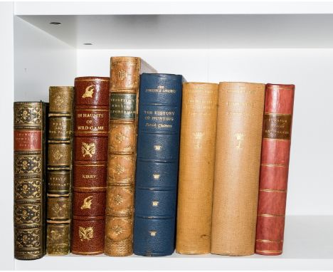
Lot 5
Hunting.- Kirby (Frederick Vaughan) In Haunts of Wild Game, engraved portrait frontispiece, plates and illustrations, folding colour map, dedication & illustration ff. with tears and loss neatly repaired, modern half-morocco, 1896 § Berkeley (Hon. Grantley F.) The English Sportsman in the Western Prairies, frontispiece, vignette title, 8 plates, scattered faint spotting, previous owner's ink inscription, bookplates, contemporary calf, gilt, slight rubbing to corners and extremities, 1861 § Boner (Charles) Chamois Hunting in the Mountains of Bavaria and in the Tyrol, coloured lithograph frontispiece and 6 plates, illustrations, scattered faint spotting, contemporary calf, gilt, 1860; and 5 others similar, 8vo (8)
Lot 85
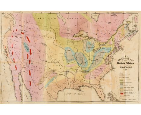
Geology.- Hitchcock (Charles Henry) Outline of the Geology of the Globe, and of the United States in Particular, first English edition, 2 folding colour maps, 6 lithographed plates, foxing, first map with short tear running into image and small patch with adhesion tearing onto title, advertisement f. at front, original cloth, spine darkened, rubbed and marked, 8vo, 1853.

Lot 13
Agriculture.- Douglas (Rev. Robert) General View of the Agriculture of the Counties of Roxburgh and Selkirk, Robert Southey's copy with his signature to title, 2 folding hand-coloured maps, 2 engraved plates, 1 folding, scattered spotting and browning, cracked hinges, original drab boards, rubbed and worn, housed in a modern drop-back box, 1813 § Pitt (w.) General View of the Agriculture of the County of Stafford, folding engraved map, 14 engraved plates of which 3 folding, scattered spotting, bookplate, near contemporary half-calf, a little rubbed, 1796 § Tuke (John) General View of the Agriculture of the North Riding of Yorkshire, hand-coloured folding map, 14 engraved plates of which 3 folding, 1 folding table, scattered spotting, contemporary half-morocco, gilt, a little rubbed, 1800 § Marshall (Mr.) The Rural Economy of Gloucestershire; including its Dairy, 2 vol., half-title to vol. 1 only, folding engraved map, advertisements at beginning vol. 1 misbound but complete, scattered faint spotting, original calf, gilt, Gloucester, 1789; 8vo (5)
Lot 132
Bindings.- Yorke (Philip, Earl of Hardwick) Athenian Letters: or, the Epistolary Correspondence of an Agent of the King of Persia, 2 vol., half-titles, engraved portrait frontispieces and 12 plates, large folding map, faint scattered spotting, contemporary calf, gilt, expert repairs to joints and corners, 1798 § Hayley (William) The Life, and Posthumous Writings, of Williams Cowper ..., 3 vol., half-titles, engraved frontispieces, 2 plates and an illustration in text by William Blake, scattered spotting, contemporary calf, rebacked, rubbed, 1803 § A'Beckett (Gilber Abbott) and John Leech, 2 vol., first edition, 20 hand-coloured plates, illustrations, scattered faint spotting, near contemporary calf by Riviere & Son, gilt, g.e., 1847-48; and 32 others, similar, 4to & 8vo (39)

Lot 144
Scotland.- Tytler (Patrick Fraser) History of Scotland, 7 vol., folding engraved map, contemporary tree calf, spines gilt with red morocco labels, vol. 1 spine and upper cover detached, vol. 3 rebacked with original backstrip laid down, vol. 7 lower portion of spine beginning to tear, some other joints beginning to crack, 1845 § Scott (Sir Walter) Marmion: A Tale of Flodden Field, ink ownership inscription to title, bookplate, very occasional spotting, contemporary diced calf, gilt, 1811 § [Burt (Edward)], Letters from a Gentleman in the North of Scotland, 2 vol., engraved frontispiece map, 5 engraved plates, woodcut head-, tail-pieces and initials, bookplates and labels, occasional light offsetting and spotting, contemporary calf with red morocco labels, joints, spine ends rubbed, 1754 § Aytoun (William Edmondstoune) Lays of the Scottish Cavaliers, illustrations by J. Paton and W. Paton, very occasional spotting, original pictorial cloth, gilt, spine and extremities a little scuffed, 1863; and 6 others Scottish history and literature, v.s. (17)
Lot 173
NO RESERVE Garnett (David) Pocahontas or The Nonparell of Virginia, frontispiece and folding map, endpapers toned, joints starting at head, 1933 § Durrell (Gerald) My Family and Other Animals, first edition, bookplate of Antony Peers to front free endpaper, covers lightly sunned at head, 1956, half-titles, occasional light spotting, original cloth, spines sunned; and c.180 others, most literature and history, v.s. (c.180)
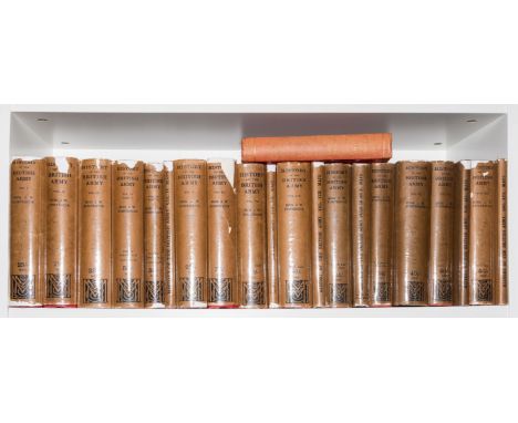
Lot 174
NO RESERVE Fortescue (Hon J.W.) History of the British Army, 13 vol. in 20, including 6 map vol., maps and plans, many folding, original cloth, slight bumping to spine extremities, dust-jackets, occasional small loss to spine extremities, 1935; The County Lieutenancies and the Army 1803-1814, first edition, scattered faint spotting, bookplate, original cloth, sunned spine, slight bumping to corners and extremities, 1909, 8vo (21).


Lot 444
John Speed C17th map of Buckingham Shyre & Shire Towne describ, with vignettes and arches, later hand coloured, two Robert Morden hand coloured maps of Somerset Shyre and another of Dunelmensis Vulgro, Durham, sold by Abel Swale and John Churchill, facsimile map of Yorkshire North Riding, 40cm x 53cm max (4)


Lot 101
MRS BEETON, Book of Household Management'. New Edtion 1906, advertisements at the front and the rear, colour frontispiece, maroon sheepskin binding, profusely illustrated with colour and black and white plates, pib. Ward, Lock & Co.; plus Mogridge (George) Wanderings in the Isle of Wight, engraved folding map, wood-engraved vignettes, occasional spotting and finger-marking, original cloth, gilt, rubbed, Religious Tract Society, 1846 (2)

Lot 69
Drawing Instruments, An ususual set in nickel plated steel, mid 20th century, by the National Emporium, Roorkee, India, including proportional dividers, with a small set by Halden, a set of large spring bow compasses, a map measurer, an adjustable parabolic curve in nickel plat and blued spring steel, etc.


![[TOPOGRAPHY]. SOMERSET Powell, Rev. Arthur Herbert. The Ancient Borough of Bridgwater, first edition, Page & Son, Bridgw](https://cdn.globalauctionplatform.com/3f396fea-240d-47a1-8382-ae1b00ebadaf/776431a7-6692-4fef-9102-ae8500c53f29/468x382.jpg)
Lot 346
[TOPOGRAPHY]. SOMERSET Powell, Rev. Arthur Herbert. The Ancient Borough of Bridgwater, first edition, Page & Son, Bridgwater, 1907, original crimson cloth, ten illustrations (including frontispiece, as called for), folding map, octavo; Powell, Rev. Arthur Herbert. Bridgwater in the Later Days, first edition, Page & Son, Bridgwater, 1908, original crimson cloth, twenty illustrations (including frontispiece, as called for), map, octavo; Robinson, W.J. West Country Manors, first edition, St. Stephen's Press, Bristol, 1930, dark green cloth, plate illustrations from photographs, octavo; and three other works, (6).

-
109182 item(s)/page