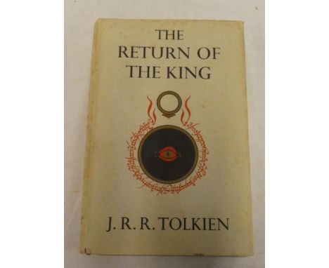
We found 109198 price guide item(s) matching your search

Refine your search

Year

Filter by Price Range
  • List
  • Grid
  • 109198 item(s)
    /page

Lot 514

Third Reich Propaganda Postcard, fine example titled “Wir haben es geschafft! Alch ih frei! Heil Hitler!”. Card shows images of civilians and military figures in woodland with map to the lower corner. Reverse with cancellation, 1938 eagle and swastika ink stamp and Czechoslovakian postage stamp. Generally good condition.

Lot 52

A collection of six maps to include an 17th century map of Buckinghamshire by Joan Blaeu together with three various printsLocation: LWM

Lot 376

Boxes and Objects - advertising tins including Columbia Gramophone Needles, Thornes Toffee, Oxo, etc; commemorative scarf the Royal visit to Salford 1905; Great War printed cloth map of Europe; Mauchline ware needle case, Ryde Pier, 8.3cm; miniature book of common prayer, 1902; powder compact, cylindrical card and knotwork and silk flowers, mirror and puff, etc

Lot 159

AN OLD MAP OF STAFFORDSHIRE

Lot 1687

A FRAMED MAP OF SOUTH SHROPSHIRE AND A FRAMED PICTURE OF SS. GREAT BRITAIN 1845

Lot 250

A VINTAGE FARM SALE SIGN 1955 'WELL FARM ADLINGTON' AND PLOT MAP

Lot 598

AN 1888 PATTER LEEMETFORD BAYONET WILKINSON SWORD, A 1917 BUTTON POLISHED GUARD AND TWO USA 50 CAL. CASES AND A 1944 DATED MAP CASE

Lot 730

3 vintage military maps approx 140 x 103 cm each - Arctic, South Atlantic, and Pacific by Army Map Service

Lot 367

Alan (Thomas) The History and Antiquities of the Parish of Lambeth, one vol, London 1826, coloured illus with map (af); and London or Interesting Memorials, vol 3 only, London 1824 (2)

Lot 381

Tolkien (JRR) The Return of the King being the third part of the Lord of the Rings, one vol, 1955,pub. G Allen & Unwin Limited, complete with map, dustjacket

Lot 384

Reid (Frank) Forty-six sketches of East African Campaign with map, one vol, Capetown 1918

Lot 408

A 19th Century hand coloured linen-backed map "Carn Brea & Tincroft Mines Ltd - Parish of Illogan, Cornwall" and proposed work for Cook's Kitchen Mine, October 1896

Lot 822

A Sokkisha map measuring device in fitted case, similar box and two Surveyors detail pole covers

Lot 1166

An impressive selection of Polish medals and military insignia spanning two World Wars formerly the property of K Szmidla including First War - 1921 period - Polish Virtuti Militari Cross 5th Class No. 3720 (minus ring suspension); Silesian Cross of Bravery; Silesian Cross of Valour and Merit; unofficial Polish Bravery Cross engraved K.S. 1920; enamelled suspended shield badge named to the 115th Polish Lancers 1920-21 and engraved "Szmidla Kourimierz Ulan"; suspended pennant engraved with initials and dated "1/7/1920"; Polish Vistula 1920 pin badge; Polish 1919-1920 pin badge; two Polish 100th Anniversary 1917 patriotic badges; a miniature 1918-1928 Anniversary of Independance medal; miniature Polish War medal 1918-1921; Polish First Light Horse Regiment enamelled Star badges, 1920s period Polish cap badges and other insignia Early Second War Period - Polish plated steel cap badge marked "DSP"; 1940 Swiss Bronze Red Cross badge; 1930s enamelled Polish army sports badge; two marksman's badges; Polish silver and enamelled "U 25" badge; various Swiss Red Cross related badges and insignia and a selection of miniature Polish Airborne "Lopp" pin badges, etc, together with various postal cards mainly dated 1940 relating to the Red Cross in Switzerland, various photographs of soldiers and invalids, etc Second War Period A selection of 8th Army cloth patches, Poland titles, 3rd Carpathian Rifle Divison patch and others, Polish 2nd Corps badge, pair of Combined Operations arm badges, Polish cap badges, original Second War Polish red beret with insignia and various other regalia, etc, together with a Polish commemorative magazine 1920-1939, Polish map, single volume "The Unknown Revolution 1917-1921"; Varsovia 1944" volume and other publications, etc

Lot 193

Rodd (EH) The Birds of Cornwall and the Scilly Islands, one vol, complete with map, London 1880; Sowerby (ADC) A Naturalists Holiday by the Sea, 1923 and Ryves (BH) Bird Life in Cornwall (3)

Lot 199

Transactions of the Royal Geological Society of Cornwall, vol 4 1832 with map, re-bound

Lot 206

Seven topography related volumes including the Settler's Guide 1914; Barber's Picturesque Illustrations of the Isle of Wight with map; Stanford's Portable Map of England; Chronicles of St Mungo or Antiquities and Traditions of Glasgow 1843, etc

Lot 209

Volney (MCF) Travels Through Syria and Egypt in the Years 1783, 1784 and 1785, vol 1 only, London 1787 with map, half calf; and Hamilton (JP) Travels Through the Interior Provinces of Columbia, vol 1 only 1827 (2)

Lot 216

Kelly's Directory of Lincolnshire, 1905 and 1930 with map (2)

Lot 219

Londonderry (Marquess of) Narrative of the Peninsular War from 1808 to 1813, vol 1 only 1829 with map; Schomberg (I) Naval Chronology, vol 1 only, London 1802; and Chamier - Ben Brace, The Last of Nelson's Agamemnons, vols 1 and 2 only, 1836 (4)

Lot 240

Johns (Rev CA) A Week at The Lizard,one vol 1848 with map; Harvey (EG) Mullyon - Its History Scenery and Antiquities, 1875; and Cummings (AH) The Churches and Antiquities of Cury and Gunwalloe in The Lizard District, 1875 (3)

Lot 255

Various West Cornwall vols including Courtney (JS) Gude to Penzance and it's Neighbourhood 1845 with map; Notes on the History of Madron, Morvah & Penzance; Early Photographs in Penzance and Newlyn; Views and Reviews - special edition Penzance; Newlyn at War and others etc

Lot 272

A Guide to the Watering Places on the Coast between the Ere and the Dart including Teignmouth, Dawlish and Torquay, one vol, Teignmouth 1817, colour illus with map, half calf

Lot 283

Campbell (Lord George) Log-letters from "The Challenger", 2nd Edition, London 1877 with map, tooled calf binding

Lot 304

Huc (M) Souvenirs d'un Voyage dans La Tartarie, Le Thibet et La Chine Pendant les Annes 1844, 1845, 1846, two vols, Paris 1850, complete with folding map, half calf

Lot 356

A linen backed folding pocket map of the British Isles - Rainfall and Temperature by Edward Stanford Limited; silk panoramic map from the summit of Snowden; Bacon's Linen Cycling road map of England and Wales and one other (4)

Lot 294

A Cartier 'Steamship world map' scarf, cream ground with grey border, with card case, in original box, 88cm squareCondition report: A very fine run to silk on bottom right hand corner, otherwise no obvious faults.See images.

Lot 224

Two boxes of oddments to include coins, keys, USA military badges, British military badges, small crossbow, folding map published at the war office, Barnstaple 1940-41 given to an American G.I soldier training on the Devon beaches, trench art type letter opener in the form of a nude lady made in one of the concentration camps in Italy during WWII, etc. (2)(B.P. 21% + VAT)

Lot 1423

A selection of framed and glazed prints to include map of Europe, a London scene etc. Not available for in-house P&P, contact Paul O'Hea at Mailboxes on 01925 659133

Lot 1442

A framed and glazed map of Cheshire and a pine framed circular wall mirror. Not available for in-house P&P, contact Paul O'Hea at Mailboxes on 01925 659133

Lot 1445

Ordnance Survey geographical UK wall map new in packaging. Not available for in-house P&P, contact Paul O'Hea at Mailboxes on 01925 659133

Lot 1070a

An early 19th Century French produced map of Ireland “chez Basset Rue de St Jaques no.670” unframed 80cms x 56cms. Viewing/collection at West Woodlands BA11 5ES. Payment at Standerwick BA11 2QB. No booking required. Lots to be collected within 7 days.

Lot 386

Alain Manesson Mallet (1630-1706) - A 17th Century antique French engraving map entitled Isle De Wigh / Isle Of Wight. Hand coloured details with depictions of maritime galleon ships. Framed and glazed. 32cm x 27.5cm.

Lot 3093

Vietnam War era US army prismatic compass dated 1962 & Pictograph jungle map dated 1965 of area 6442 III. P&P Group 1 (£14+VAT for the first lot and £1+VAT for subsequent lots)

Lot 372

CARTON OF OLD MAP GUIDES ETC

Lot 427

4 F/G PICTURE - 1 BEING A MAP OF THE BRITISH ISLES ANOTHER A VICTORIAN PAINTING OF THE GREAT ORME LLANDUDNO 1874

Lot 652

BOX OF 12 ASSORTED PICTURES INCLUDING ANTIQUE MAP OF BUCKINGHAMSHIRE A MAP OF THE EAST INDIES, SHEFFIELD TRAM A SAILING SHIP ETC ETC.

Lot 141

K. Simpson [Contemporary]-Topsham Tube Map,:-signed and dated 2014mixed media, 42 x 56cm.

Lot 1648

A gilt metal curb link bracelet, fitted with a 9ct gold heart shaped padlock clasp and six gold charms (7)The six gold charms including a fan, a Viking ship and a map of Portugal, combined gross weight of the charms 9.2 gms

Lot 234

18th century engraving- map of Colchester by Thomas Sparrow, 1767, 52cm x 70.5cm in glazed frame, together with a print of a map of Essex in glazed oak frame (2)

Lot 98

Players Association footballers cigarette cards, together with other cards in a glazed frame, reproduction map and other prints

Lot 171

De Dion Bouton. An interesting multi-fold promotional broadsheet, one side discussing patents and designs from 1883 through to 1926, the other with illustrations. Also, a similar promotional broadsheet with a map of the north-west area of France and a list of agencies, and depictions of DDN motorcars for the veteran period (1907). (2)

Lot 91

Review of the Fleet, Spithead, 1911. A framed, mounted and glazed colour-printed map published at The Admiralty, London, on 1st June 1911, showing the position of the naval fleet at Spithead on 24th June 1911 for the review by His Majesty the King, the map within a mount decorated with colour British Empire flags and monochrome photographic images of four of the ships. A pocket on the reverse of the frame holds a 16-page detailed list in card covers of the ships taking part. Size of map 13 x 21-inches (33 x 53.5cm), frame size 21.75 x 28.25-inches (55 x 71.5cm).

Lot 246

A 17th century map of Essex, by Norden and Speede, framed, with open back showing text.Condition report: Good general condition, some dark ink marks in margins at corners, some brown staining and sellotape residue visible on back

Lot 299A

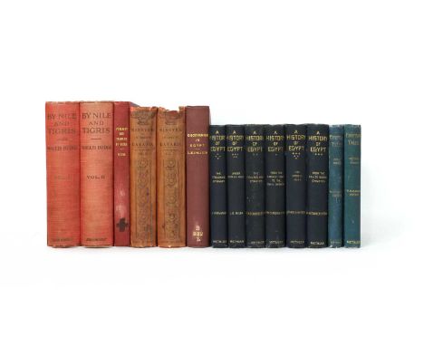
EGYPTOLOGY: 1- Budge, E.A. Wallis: By Nile and Tigris, A Narrative of Journeys in Egypt and Mesopotamia, in 2 volumes. John Murray, 1920, 1st. edn. With a folding map & plates. Original red cloth with gilt head to upper covers. VG set; 2- Lepsius, R: Discoveries in Egypt, Ethiopia, Peninsula of Sinai, in the years 1842 – 1845. Bentley, 1852, 1st. edn. With colour lithograph frontis and a folding map (torn, without loss). Plain cloth rebound; 3- Layard , A H: Nineveh & Its Remains, in 2 volumes. Murray, 1849, 1st. edn. All plates present. Original pictorial cloth, cuts to spines; 4- Petrie, W M F: The Pyramids and Temples of Gizeh. Field & Tuer, new & revised edn. No date, C1897. Plain cloth rebound; 5- Petrie, W M F: A History of Egypt, in 6 volumes. Methuen, 1894-1905; PLUS: Egyptian Tales, in 2 vols. Methuen, 1899-1913. All 8 volumes in the original matching cloth binding with gilt decoration to upper covers; Very good set. (14)

Lot 47

A rare 1930's Great Western Railways route map station map, marked Emery Walker Ltd Inv et Sc 48cm by 68cm, .and 8 other assorted folding maps

Lot 261

A coffee table with map of the World adorning the top, of square form, 32cm x 46cm x 44cm

Lot 275

A modern map of Somersetshire, framed and glazed, 42cm x 52cm including frame

Lot 300

A reproduction map of Somerset, published by J.Cary, framed and glazed, 30cm x 25cm

Lot 347

After Emanuel Bowen, An Accurate Map of Buckinghamshire, Divided into its Hundreds, 73cm x 55cm, framed.

Lot 323

A Framed Oil on Board, Woodland Lake and a Map of Shropshire

Lot 414

Collection of eight various framed map prints.

Lot 353A

MacKenzie and Dent, A Historical and Descriptive view of the County of Northumberland, 2 vols, 8vo, half calf, illus with fold out map, Newcastle 1811.

Lot 468A

'Northumberland' extracted from 18th Century Cox's Magna Britannia, including folding Morden map; and Pigot's Directory for Northumberland, republished in August 1978 by Keenley Press, Allendale, facsimile edition limited to 600 copies. (2 vols)

Lot 1454

Two examples of Needlework. One is 19th century Victorian, showing a map of the British isles (approximately 68cm x 55cm), the frame has one missing foot at the bottom as pictured. The other Is Likely 1920's-1930's, and is a scene of a woman in a garden by a cottage (approximately 27cm x 26cm), there is writing on the back as pictured - NO RESERVE

Lot 1470

A framed late 19th drawing of sea clipper and a framed 18th street map of London dated June 22 1792. (2)

Lot 1569

A pair of field glasses together with a meerschaum pipe, map of Western Germany and a steel blade dagger in wooden scabbard

Lot 252

Cecily Peel (1892-1984) a map of Oxford, hand coloured lithograph, 48cm x 52cm, framed and glazed together with a hand coloured map of Oxfordshire after Robert Morden, 43cm x 36cm, framed and glazed, overall 52.5cm x 60cmCondition report: Both good with no major damages or marks, the Morden map satinwood frame with some chips and marks

Loading...Loading...
  • 109198 item(s)
    /page

Recently Viewed Lots