
Cooley (William Desborough). Inner Africa Laid Open, in an Attempt to Trace the Chief Lines of Communication across that Continent South of the Equator: With the Routes to the Muropue and the Cazembe, Moenemoezi and Lake Nyassa; the Journeys of the Rev. Dr. Krapf and the Rev. J. Rebmann on the Eastern Coast, and the Discoveries of messrs. Oswell and Livingstone in the Heart of the Continent, 1st edition, 1852, half title, folding map, advertisements at rear, stitching weak, some leaves detaching, offsetting from map to title, light marginal toning, previous owner ink stamp at head of title and at front, original cloth, rebacked, some edge wear and stains, 8vo, together with The New Africa. A Journey up the Chobe and down the Okovanga Rivers. A Record of Exploration and Sport, by Aurel Schulz, M.D. and August Hammer, C.E., 1st edition, 1897, portrait frontispiece, folding map (repaired), illustrations, advertisement leaf at end, light spotting, presentation inscription, original cloth, a little rubbed with some fading, 8vo, plus The Ila-Speaking Peoples of Northern Rhodesia, by Rev. Edwin W. Smith & Captain Andrew Murray Dale, 2 volumes, 1st edition, 1920, folding map, illustrations, some light spotting, previous owner inscriptions, original cloth, spines darkened and rubbed at ends, 8vo, with other Africa related including Sir Charles Eliot's The East Africa Protectorate, 1905 and Cullen Gouldsbury & Hubert Sheane's The Great Plateau of Northern Rhodesia, 1911 (22)
We found 109198 price guide item(s) matching your search
There are 109198 lots that match your search criteria. Subscribe now to get instant access to the full price guide service.
Click here to subscribe- List
- Grid
-
109198 item(s)/page
Livingstone (David & Charles). Narrative of an Expedition to the Zambesi and its Tributaries; and of the Discovery of the Lakes Shirwa and Nyasa. 1858-1864, 1st edition, 1865, folding wood-engraved frontispiece, folding engraved map (with closed tear), publisher's 32 page catalogue at end, illustrations, title detaching, armorial bookplate, original burgundy cloth gilt, spine faded with small tears at ends, a few flecked stains, 8vo, together with The Last Journals of David Livingstone, in Central Africa, from 1865 to his death. Continued by a narrative of his last moments and sufferings, obtained from his faithful servants Chuma and Susi, by Horace Waller, 2 volumes, 1st edition, 1874, portrait frontispiece to volume I, two folding maps (one contained in volume I rear pocket), wood-engraved illustrations, publisher's catalogue at end of volume II, some light spotting, original cloth gilt, spines faded with small tears at ends, 8vo, with three others including Narrative of an Expedition to the Zambesi and its Tributaries, 1st US edition, New York, 1866, and Missionary Travels and Researches in South Africa, 1857 (lacking one map) (6)
Park (Mungo). The Journal of a Mission to the Interior of Africa, in the Year 1805. Together with Other Documents, Official and Private, Relating to the same Mission. To which is Prefixed an Account of the Life of Mr. Park, 1st edition, 1815, half title, folding engraved map (offset to part title opposite), a few minor spots, contemporary half calf, rebacked, original spine relaid, spine label renewed, 4to (1)

Salt (Henry). A Voyage to Abyssinia, and Travels into the Interior of that Country, executed under the Orders of the British Government, in the Years 1809 and 1810, 1st edition, F. C. and J. Rivington, 1814, 7 maps and charts (4 folding, 1 coloured and folding), 27 engraved plates, bound without the half-title, creasing to endpapers, title page and final text-leaf, occasional light browning, tears to inner folds of folding colour map, repairs verso, contemporary streaked calf, rebacked with the original spine gilt spine laid down, rear board slightly scuffed and skilfully restored, 4to (30 x 22.5 cm) Blackmer 1479; Czech Africa p. 141. (1)
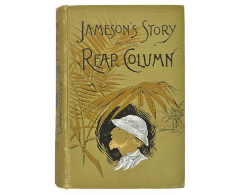
Schweitzer (Georg). Emin Pasha, his Life and Work, frontispiece, folding map, endpapers browned, Baron Llangattock bookplates, edges untrimmed, original blue cloth, spines very slightly faded, a few small marks, a bright copy, 8vo, together with Mounteney-Jephson (A. J.), Emin Pasha and the Rebellion at the Equator, 1st edition, Sampson Low, Marston, Searle & Rivington, 1890, photogravure portrait frontispiece, folding colour map, folding facsimile of the Mahdi's letter (in Arabic), 21 plates, illustrations to the text, very mild occasional spotting, original pictorial red cloth, extremities very slightly rubbed and bumped, faint discolouration to rear board, 8vo, plus Jameson (James S.) The Story of the Rear Column of the Emin Pasha Relief Expedition, authorized edition, New York: United States Book Company, [1890], frontispiece, numerous text illustrations, 2 folding maps (1 repaired), original pictorial green cloth, extremities slightly rubbed, 8vo, and Wauters (A. J.), Stanley's Emin Pasha Expedition, 1st edition, John C. Nimmo, 1890, frontispiece, 33 plates, folding map, occasional spotting, short closed tear to map, original green cloth gilt, extremities slightly rubbed, spine rolled, 8vo, and 6 others including first-hand Rear Column accounts, all original cloth, 8vo (12)

Selous (Frederick Courteney). Sunshine and Storm in Rhodesia, 1st edition, Rowland Ward & Co., Limited, 1896, photographic frontispiece, 8 plates, text illustrations, folding map, zebra-print endpapers, original tan cloth, rubbed and variably darkened, spine rolled, 8vo, together with Maxse (Frederick Ivor), Seymour Vandeleur, the Story of a British Officer, 1st edition, The National Review Office, 1905, frontispiece, 13 plates (many coloured), 9 folding maps and plans, light spotting, marginal tide-mark to plates and maps, top edge gilt, others untrimmed, original vellum, 4to, number 77 of 150 copies initially by the author, plus Schreiner (Olive), Dreams, 3rd edition, T. Fisher Unwin, 1891, frontispiece, signed by the author 'Olive Schreiner, June 17th 1897' on the title page, contemporary dark green full morocco for Bumpus, joints slightly rubbed, 8vo, and 62 others, all concerning southern Africa, late-19th or early-20th century, travel, military, politics, mainly original cloth (70)

Stanley (Henry M.). In Darkest Africa, 2 volumes, 1st edition, deluxe issue, 1890, 2 heliogravure portrait frontispieces and 36 wood-engraved plates, all on india paper, mounted, 6 etched plates by Montbard, signed by the artist in pencil, all with tissue-guards, 3 folding colour maps (2 linen-backed), 1 leaf of manuscript facsimile, 1 geological profile, numerous wood-engravings to the text, 1 additional wood-engraved plate not listed in contents (group portrait facing p. xiii volume 2), spotting to etched plates, additional plate and versos of linen-backed maps, mild spotting to volume 1 frontispiece and folding map, heavier spotting to etched plates and folding map versos, top edges gilt, others untrimmed, original black half morocco over bevelled boards, titles and decoration to japon sides gilt, japon mottled, extremities rubbed, demy 4to Number 27 of 250 deluxe copies signed by Stanley on the limitation page. (2)
Stanley (Henry M.). The Congo and the Founding of its Free State: A Story of Work and Exploration, 2 volumes, 1st edition, 1885, portrait frontispieces, folding map contained in rear pocket of each, illustrations, publisher's catalogue at end of volume II, a few light spots to titles, small Sotheran ink stamps at head of front endpapers, original pictorial cloth gilt, tiny tears at head of volume II spine, one corner bumped, 8vo (2)
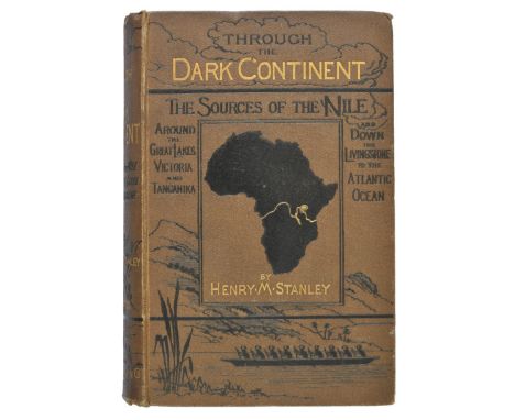
Stanley (Henry M.). Through the Dark Continent or the Sources of the Nile around the Great Lakes of Equatorial Africa and down the Livingstone River to the Atlantic Ocean, 2 volumes, 1st edition, 1878, portrait frontispieces, folding map contained in rear pockets, maps and illustrations, publisher's list at end of volume II, Blackie & Son Private Library labels and shelf numbers at front, original pictorial cloth gilt, small split to lower joint of volume I, spines ends a trifle rubbed, 8vo (2)
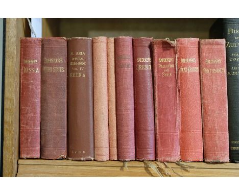
Baedeker (Karl). Russia with Teheran, Port Arthur, and Peking, 1st edition in English, 1914, folding maps and plans, map of Southern Siberia and Turkestan (opposite Page 497) torn in half but complete, bookseller's ticket to title, original cloth, spine rubbed and a little frayed on upper joint, together with The United States with an Excursion into Mexico, 1st edition in English, maps and plans as listed including large general map at rear, original cloth, rubbed and slightly soiled, spine faded and frayed at extremities, plus Imperial Japanese Government Railways. An Official Guide to Eastern Asia, Vol. IV: China, [1915], folding maps and plans including one map in pocket at rear, illustrations to text, lacks title (?), a little occasional spotting and soiling, inner hinges cracked, original cloth, rubbed, plus six further Baedeker publications, all small 8vo (10)
Stanley (Henry M.). Coomassie and Magdala: The Story of Two British Campaigns in Africa, 2nd edition, 1874, portrait frontispiece, two folding maps, illustrations, a few light spots, partly unopened, endpapers renewed, original green cloth gilt, spine a little darkened and rubbed at ends, 8vo, together with Through the Dark Continent or the Sources of the Nile around the Great Lakes of Equatorial Africa and down the Livingstone River to the Atlantic Ocean, 2 volumes, 1st US edition, New York, 1878, portrait frontispieces, folding map contained in rear pockets, maps and illustrations, slight marginal toning, small water stain at foot of a few leaves in volume II, original green pictorial cloth gilt, edges a little rubbed, slight bowing to covers, 8vo, plus My Dark Companions and their Strange Stories, 1st edition, 1893, illustrations, presentation inscription, endpapers lightly toned, front hinge tender, original cloth gilt, light edge wear, 8vo, with three others: Coomassie and Magdala, 1874, How I Found Livingstone: Travels, Adventures and Discoveries in Central Africa, 1872, and The Congo and the Founding of its Free State, 2 volumes, 1885, all 1st US editions (8)
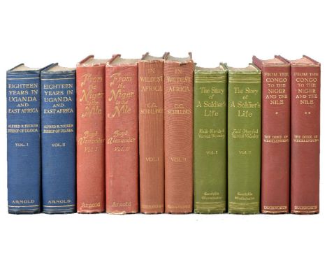
Tucker (Alfred R.). Eighteen Years in Uganda & East Africa, 2 volumes, 1st edition, Edward Arnold, 1908, photogravure frontispiece to volume 1, 60 plates from watercolours (4 in colour), folding colour map, 16-page publisher's catalogue, mild spotting to prelims, photogravure, map and page-edges, original blue cloth gilt, extremities very lightly bumped and rubbed, a few trivial marks, volume 2 spine rolled, 8vo, together with Wolseley (Garnet, 1st Viscount), The Story of a Soldier's Life, 2 volumes, 1st edition, Archibald Constable & Co Ltd, 1903, photogravure frontispieces, 3 plans (2 folding), title pages in red and black, top edges gilt, others untrimmed, original green cloth gilt, extremities very lightly rubbed and bumped, 8vo, plus Alexander (Boyd), From the Niger to the Nile, 2 volumes, 1st edition, Edward Arnold, 1907, half-tone frontispieces, 42 similar plates, numerous text illustrations, 2 folding maps, light spotting, contemporary newspaper cutting mounted to volume 1 front free endpaper and offset to half-title, a few marginal nicks to volume 1 frontispiece, plate facing p. 2 volume 2 chipped to no loss of image, original red cloth gilt, spines faded, extremities lightly rubbed and bumped, spine-ends nicked, 4to, and Mecklenburg (Adolf Friedrich, Duke of, & others), From the Congo to the Niger and the Nile, an Account of the German Central African Expedition of 1910-1911, 2 volumes, 1st edition in English, Duckworth & Co., 1913, numerous photographic and other plates, folding map, text-block spotted, bookplates of Ernest E. Testi, endpapers browned, top edges dyed red, original red cloth, a few pale marks, 8vo, and 1 other Wolseley's Story is inscribed on the half-title of the first volume 'Dudley Alexander, with best wishes for the new year, from A J Mounteney Jephson, New Year 1904', with the engraved bookplate of the recipient, Major Dudley Alexander CMG (1863-1931) to front pastedown. Mounteney-Jephson (1859-1908) was a member of the Emin Pasha Relief Expedition. (10)
Weale (J.P. Mansel). The Truth about the Portuguese in Africa, 1st edition, 1891, small map to verso of half title, a few manuscript annotations and corrections by the author, some toning to endpapers (rear endpaper with small repair), original green cloth, spine ends a little rubbed, 8vo Author's presentation copy, lengthy inscription to Empress Frederick of Germany (1840-1904) on half title. (1)

Wingate (Sir Reginald). Mahdiism and the Egyptian Sudan, being an Account of 9 folding colour maps, 4 folding plans, 1 folding map in end-pocket, 15 other maps and plans, inscribed by the author 'J. M. Cook, with F. R. Wingate's kindest remembrances, London, Oct. 1891' on the half title, endpapers renewed, original red cloth, spine faded, front board marked, extremities bumped, 8vo, together with Petherick (John), Egypt, the Soudan and Central Africa, with Explorations from Khartoum on the White Nile to the Regions of the Equator, being Sketches from Sixteen years' Travel, 1st edition, Edinburgh: William Blackwood and Sons, 1861, lithographic folding map, spotting to endpapers and prelims, occasionally to text, prelims creased, front inner hinge cracked but firm, ink-stamps of big-game hunter Henry Thomas Glynn (1856-1928), original brown cloth, a few marks to spine, head and foot frayed, board-corners worn, 8vo, plus Gessi (Romolo), Seven Years in the Soudan, being a Record of Explorations, Adventures, and Campaigns against the Arab Slave Hunters, 1st edition, Sampson Low, Marston & Company, 1892, frontispiece, 11 plates, light spotting, ink-stamps of Glen Ewin, front inner hinge superficially cracked, original pictorial blue cloth, slightly rubbed, 8vo, and 11 similar works Presentation copy of Mahdiism and the Egyptian Sudan; the recipient was probably John Mason Cook (1834-1899), son of the travel agent, Thomas. He took full control of the company in 1878, and under his auspices Thomas Cook & Son were responsible for the transfer of wounded soldiers to Cairo the Battle of Tell el-Kebir in 1882, and provided river transportation for the abortive Gordon Relief Expedition of 1884-5. (16)
Aikin (J.). A Description of the Country from thirty to forty Miles round Manchester..., 1st edition, published John Stockdale, 1795, engraved allegorical frontispiece, additional engraved title (additional title detached), list of subscribers, forty-five uncoloured engraved plates and sixteen engraved maps, with two additional plates not called for, two large folding maps (one with contemporary outline colouring), one folding map with folds partially repaired on verso, occasional spotting and staining, later endpapers, modern cloth gilt, 4to (1)

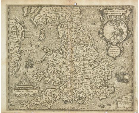
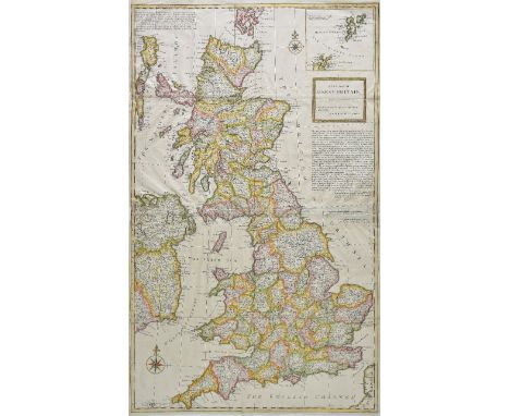
Blome (Richard). Britannia: or a Geographical Description of the Kingdoms of England, Scotland and Ireland with the Isles and Territories thereto belonging..., Illustrated with a map of each county of England besides several general ones. The like never before published, printed Tho. Roycroft for the Undertaker, Richard Blome, 1673, title page printed in red & black, dedication to Charles II, preface and five pages of tables and twenty-four pages displaying 808 heraldic shields, folding engraved map of the British Isles, forty-four double page engraved county maps, a plan of London and five folding maps of North Wales, South Wales, Scotland, Ireland and British Islands (complete as list), title page and dedication detached, upper hinge cracked, near contemporary calf gilt with later morocco gilt label to spine, worn and rubbed, folio William Nicholson, the Bishop of Carlise condemned Blome's Britannia 'as a most entire theft out of Camden and Speed'. Most cartographers borrowed from the works of earlier atlases this makes Nicholson's condemnation somewhat harsh and certainly overlooks the fact that Blome's maps have a charming naivety which has never been replicated. The six folding maps in this atlas are often trimmed and damaged. The examples contained in this example are in surprisinly good condition. Chubb XCIX, Skelton 90. (1)

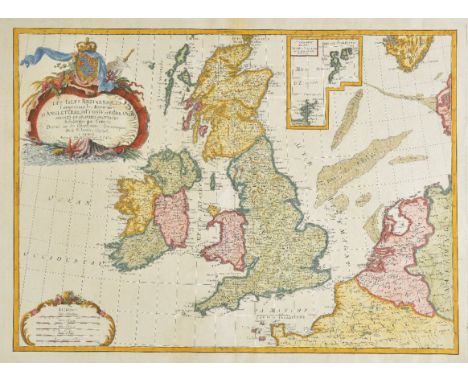
Camden (William). Britannia: or a chorographical description of Great Britain and Ireland, together with the adjacent islands..., 2 volmes, 2nd edition, revised, digested and published with large additions by Edmund Gibson, printed by Mary Matthews and sold by William Taylor, 1722, title pages to each volume printed in red & black, portrait frontispiece, dedication and preface, nine plates of coins, additional half title, page 106 with short marginal closed tear, fifty-one uncoloured engraved folding maps by Robert Morden, map of Hampshire with two small holes, map of Cheshire and Herefordshire with repaired holes, occasional spotting, book plate of John Angerstein, near contemporary calf gilt, rebacked, worn and rubbed, folio Chubb CXV. (2)
Camden (William). Britannia siue Florentissimorum regnorum, Angliae, Scotiae, Hiberniæae, et insularum adiacentium ex intima antiquitate chorographica descriptio...., Nunc postremò recognita, & magna accessione post Germanicam aeditionem adaucta, London: George Bishop, 1600, additional engraved title with slight loss to upper outer corner and lower edge, woodcut Royal arms to letterpress title, two double-page engraved maps (both detached, a little frayed to edges, first map with small burn hole to blank margin at head touching neat line), eight full-page engraved illustrations, several woodcut illustrations and decorative initials, lacking final blank 3N4, upper outer corners of initial leaves frayed with loss to blank margins, ink name stamp W. Burdet to A8, short tear to fore-edge margin of B7 & B8, worm trail to lower margins of 2R7-2V1, some dampstaining, dust-soiling and few marks, later endpapers, early 18th century panelled calf, neatly rebacked, with new morocco title label, corners repaired, 4to STC 4507. (1)
Harrod (William). The History of Mansfield and it's Environs, in two parts: I. Antiquities including an accurate Description of two Roman Villas, near Mansfield Woodhouse, discovered by H. Rooke, Esq. in the Year 1786..., II. the Present State, Mansfield: Printed and sold by it's author, 1801, 15 engraved plates including frontispiece (4 folding and 2 hand-coloured), folding engraved map, modern gilt panelled and decorated red morocco by A. Price of Oxford, 4to, together with Shilton (Richard Phillips), The History of the Town of Newark Upon Trent, in the County of Nottingham, comprising an account of its Antiquities, Edifices, Public Institutions, Charities, Charters, etc., 2 parts in one, Newark: S. and J. Ridge, 1820, two engraved plates (including frontispiece) and two folding tables, top edge gilt, modern gilt decorated green calf by A. Price of Oxford, red morocco labels to spines, small 8vo (2)
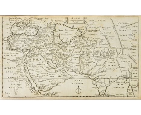
Diodorus Siculus The Historical Library of Diodorus the Sicilian, in Fifteen Books. The First Five, contain the Antiquities of Egypt, Asia, Africa, Greece, the Islands, and Europe, the Last Ten, an Historical Account of the Affairs of the Persians, Grecians, Macedonians, and other Parts of the world ... made English, by G. Booth, 1st edition, 1710, 3 maps of which 2 folding ('Antient Sicele according to the Description of Philip Cluevius'; 'The Map of Antient Greece expressing especially the places mentioned in Thucydides by Tho. Hobbes'; 'Asia, veteribus cognitae tabula'), bookplate neatly removed from front pastedown, main title browned, marked and chipped, variable spotting and browning, Sicily map spotted, short closed tear to inner margin of Greece map, 'The Last Ten Books' divisional title misbound after 4X2, contemporary panelled calf, rebacked and recornered, sides slightly worn, folio in fours, together with a copy of the 'second edition', 1721, title page printed in red and black, engraved bookplate, small tide-mark to bottom edge of Sicily map, map of Greece substantially torn away, Asia map clean, contemporary calf, rubbed, extremities worn, joints cracked and held by cords, folio in fours Wing D1512; the accompanying 'second edition', published in 1721, is really 'a reissue of the 1700 edition with a cancel title page' (ESTC). Booth's translation was the first complete edition in English of the Bibliotheke, which is an important source for the Middle East in antiquity. (2)
Laurie (Robert and Whittle, James). New Traveller's Companion; exhibiting a complete and correct survey of all the direct and principal cross roads in England, Wales and Scotland, as far north as Edinburgh and Glasgow: to which have been added the roads to Perth & Aberdeen, Greenock, Irvine, Ayr, Port Patrick, Wigtown, &c. by Nathl: Coltman, 3rd edition, corrected to 1809, Laurie & Whittle, 1809, double-page engraved title, with hand-coloured border, double-page engraved explanation table, three double-page printed index leaves, and one single-page printed advertisements and directions, folding engraved general map of England & Wales, hand-coloured in outline, and 23 double-page engraved road maps (numbered 1-15, 17-20 and 21-25), generally in good condition, contemporary black morocco, rebacked and edges renewed, large 8vo (28 x 17.5 cm, 11 x 7 ins), together with Bristow (Henry William), The Geology of the Isle of Wight (Memoirs of the Geological Survey. England and Wales), 2nd edition, revised and enlarged, by Clement Reid and Aubrey Strahan, 1889, 5 folding lithographed maps and plans at rear, including 4 with hand-colouring, original blindstamped cloth gilt, rubbed and some marks and fading to spine and edges, large 8vo, plus Fraser's Travelling Map of Ireland, shewing all the towns, lakes, rivers, roads, and railways, Dublin, M.H. Gill & Son, 1888, uncoloured lithograph map, sectionalised on linen, some marks and minor discolouration, original blindstamped green cloth gilt, rubbed and marked and some soiling, slim 8vo, and 3 others (6)
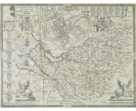
Leycester (Sir Peter). Historical Antiquities, in Two Books. The First Treating in General of Great-Brettain and Ireland. The Second Containing Particular Remarks Concerning Cheshire......., Whereunto is annexed a Transcript of Doomsday-Book, so far as it concerneth Cheshire, taken out of the Original Record, published W. L. for Robert Clavell, 1673, title page printed in red & black, dedication to Charles II, folding uncoloured engraved map of Cheshire by John Speed (Roger Rea published), several heraldic crests to text throughout, later endpapers, bookplate of Gloddaeth Library, near contemporary speckled calf, upper board detached, rubbed and worn, folio Wing L1943. The book contains a loosely inserted early 17th century manuscript document, possibly a section of a will. (1)
Paterson (Daniel). Paterson's British Itinerary being a New and Accurate Delineation and Description of the Direct and Principal Cross Roads of Great Britain, 2 volumes, 1st edition, 1785, engraved title to each volume and dedication leaf, hand-coloured double-page map, 358 engraved strip maps on 91 leaves, printed back-to-back, contemporary marbled calf, joints cracked, upper board to volume 2 detached, spines worn and lacking labels, board edges worn and showing, 8vo, together with a worn copy of Cary's New Itinerary: or, an Accurate Delineation of the Great Roads..., 3rd edition, with improvements, 1806 (3)
[Duguid, Charles]. The Desert Trail with the Light Horse through Sinai to Palestine, by Scotty's Brother, 2nd edition, Adelaide, 1919, 2nd edition with Arthur Blackburn's testimonial to page iii and Acknowledgements to verso, folding map, half-tone illustrations, contemporary presentation inscription at front, contemporary half calf, a little rubbed with tear at head of spine, 8vo, together with Through Palestine witn the Twentieth Machine-Gun Squadron, printed and published by J.M. Baxter for private distribution, [1920], folding maps, five half-tone illustrations, light spotting, original pictorial cloth, rubbed with a few stains, 4to, plus With the Cameliers in Palestine, by John Robertson, 1st edition, Dunedin, 1938, maps and illustrations, a few spots, previous owner signature, original cloth, spine faded and rubbed at ends, 8vo (3)
Rose (Thomas). Westmorland, Cumberland, Durham & Northumberland illustrated from original drawings by Thomas Allom &c., published Fisher Son & Co., 1832, decorative title, 152 uncoloured engraved topographical views on seventy-six sheets, upper hinge cracked, all edges gilt, contemporary half morocco gilt, worn at extremities, 4to, together with Baines (Edward), The History of the County Palatine and Duchy of Lancaster, 2 volumes, published George Routledge and Sons, Manchester, 1868, additional half title, folding hand-coloured lithograph map frontispiece of Lancashire, numerous engraved illustrations throughout, extra illustrated, some spotting, hinges and joints weak, contemporary half morocco gilt, spine partially lacking on volume 1, worn and rubbed, 4to (3)

Senex (John). The Roads through England delineated or, Ogilby's Survey, Revised, Improved and Reduced to a size portable for the Pocket..., with the addition of some roads newly drawn, which were omitted by Mr Ogilby, and several necesary corrections made in others..., London: John Bowles, 1762, engraved calligraphic title, six pages of tables, engraved map of England & Wales trimmed to neatline, 101 (complete) uncoloured engraved strip road maps printed back to back, slight toning and occasional staining, later pastedowns, modern limp brown calf, oblong 8vo (1)

Buckland (William). Reliquiae Diluvianae; or, Observations on Organic Remains Contained in Caves, Fissures, and Diluvial Gravel, second edition, John Murray, 1824, 27 engraved plates including three hand-coloured maps and plans (one folding), folding letterpress table, frontispiece map offset to title, occasional spotting, contemporary half calf, rubbed, a little wear to corners and slightly cracked along upper joint, together with King (William), A Monograph of the Permian Fossils of England, Palaeontographical Society, 1850, 29 uncoloured lithographic plates including some folding, offsetting to text and plate 6 inverted, lacks half-title, modern green half calf gilt over marbled boards, both 4to (2)

Africa. Senex (John), A New Map of Africa wherein are particularly express'd the European Forts and Settlements drawn from the most approved geographers with great improvements from the Sieurs D'Anville & Robert, published Robert Sayer, circa 1760, large engraved map on two conjoined sheets with contemporary hand colouring, slight creasing, old folds, 580 x 950 mm (1)
![Americas. Von Reilly (Franz J. J.), Karte von Amerika nach D'Anville und Pownall, [1795], engraved map with contemporary outl](https://cdn.globalauctionplatform.com/1580937d-4450-45cf-b668-a8d500d52e36/44830905-c758-477b-9ba8-1054ed35c757/468x382.jpg)
Americas. Von Reilly (Franz J. J.), Karte von Amerika nach D'Anville und Pownall, [1795], engraved map with contemporary outline colouring, inset maps of the thirteen states of the Republic of North America, Alaska & Cook Strait, Hudson's Bay and Greenland, old folds, some dust soiling, several repaired marginal closed tears, old folds strengthened and repaired on verso, slight staining, 590 x 765 mm, together with Thomson (J.), America, published Edinburgh, circa 1816, engraved map with contemporary outline colouring, 515 x 605 mm (2)


Australia. Arrowsmith (John), The South Eastern Portion of Australia compiled from the Colonial Surveys..., 1841, engraved map with contemporary outline colouring, sectionalised and laid on linen, inset map of Australia, 520 x 635 mm, contained in a contemporary cloth slipcase with a later printed label to upper board A good clean example. (1)

Belgium & Luxembourg. Senex (John), A new and correct map of the Ten Spanish Provinces according to the new observations comunicated to the Royal Society at London and the Royal Academy at Paris, 1714 [or later], engraved map with contemporary hand colouring on two conjoined sheets, the title set into a cartouche of a fortified town surrounded by machines of war, slight marginal dust soiling, 640 x 955 mm, together with A New Map of the Provinces of Hainault, Naumur and Cambray, A Map of the County of Flanders..., [and] The Provinces of Artois and the Country adjacent, [1712 or later], together three engraved maps of Belgium and the Low Countries, all with contemporary hand colouring, old folds, the map of Artois with a long repaired closed tear affecting image, each approximately 490 x 605 mm (4)

Fraser (James). The History of Nadir Shah, formerly called Thamas Kuli Khan, the Present Emperor of Persia. To which is prefix'd a Short History of the Moghol Emperors. At the End is inserted a Catalogue of about Two Hundred Manuscripts, in the Persic and Other Oriental Languages, collected in the East, 1st edition, printed by W. Strahan, for the Author, 1742, engraved folding frontispiece, folding map (browned), bookplate of Calwich Abbey and ownership inscriptions to front pastedown, contemporary mottled calf, rebacked to style preserving original spine label, tips worn, 8vo Blackmer 629. 'Fraser was resident at Surat from 1730-40 and then returned as factor the East India Company, 1743-9. This work is important for a number of documents preserved here only'. (1)
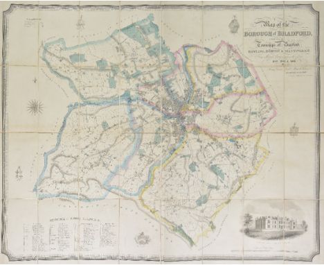
Bradford. Dixon (Thomas), Map of the Borough of Bradford comprising the townships of Bradford, Bowling, Horton & Manningham, from actual surveys made in the years 1844, 1845 & 1846, published Bradford, June 1846. large engraved map, sectionalised and laid on linen, bright original outline colouring, calligraphic title, compass rose, table of reference and engraved vignette of Bradford Infirmary, very slight offsetting, 1140 x 1420 mm, contained in an orginal gilt cloth slipcase with blind embossed arabesque on both boards, gilt title to spine, slipcase a little worn at extremities (1)
British Isles. Moll (Herman), A new map of Great Britain according to the newest and most exact observations, 1st edition, published 1717, large hand coloured engraved map on two sheets conjoined, inset map of the Shetland Islands, picture frame cartouche and compass rose, old folds strengthened on verso, slight fraying to left hand vertical margin, repaired, slight staining, 1025 x 625 mm R.W.Shirley, Printed Maps of the British Isles, 1650 - 1750, Moll 7. state 1. (1)
British Isles. Janvier (Jean), Les Isles Britanniques Comprenant les Royaumes D'Angleterre, D'Ecosse et D'Irlande, Divisés en Grandes Provinces, Subdivisés par Comtés, Dressés sur les Observations Astronomiques, published Venice, circa 1780, engraved map with contemporary outline colouring and some later enhancement, inset map of the Orkney and Shetland islands, 470 x 645 mm, together with, Homann (Johann Baptist), Magna Britannia complectens Angliae, Scotiae et Hiberniae Regna..., circa 1710, engraved map with contemporary hand colouring, some dust soiling and staining, central fold split and repaired, vertical borders trimmed with margins extended, 480 x 565 mm The second item described. R. W. Shirley. Printed Maps of the British Isles, 1650 - 1750. Homann 2 state 1. (2)
British Isles. Bossuet (Jacques Benigne), Isles Britanniques, circa 1722, hand coloured engraved map, 130 x 165 mm, with another copy similar but published by Sanson, together with De La Croix (A. Pherotee), Les Isles Britanniques ou les Royaumes D'Angleterre, D'Ecosse et D'Irlande avec les Isles qui en depandent, circa 1705, hand coloured engraved map with sixteen heraldic shields to the vertical margins (including one blank), old folds, trimmed with slight loss to margin in lower left, 150 x 215 mm, with Mercator (Gerard), Anglis, Scotia et Hibernia, circa 1631, hand coloured engraved map, 145 x 205, German text on verso, plus Bertius (Pieter), Magna Britannia, [1618], hand coloured engraved map, orientated to the east, 95 x 135 mm, French text on verso, and De la Feuille (Paul), Angliae Scotiae et Hiberniae Regnam circa 1738, hand coloured engraved map, 145 x 175 mm, together with Du Val (Pierre), Insulae Britanniae [and] Anglia, circa 1681, two uncoloured engraved maps, trimmed to neatline, 'Insulae Britanniae' with old fold repaired on verso, each approximately 100 x 130 mm, with two others similar by Senex and Wells, various sizes and condition (10)

British Isles. Stukeley (William & Bertram Richard), Mappa Brittaniae Facie Romanae Secundum Fidem Monumentorum Perveterum Depicta, [1757], hand coloured engraved map of the British Isles, orientated to the west, 325 x 390 mm A cartographic curiosity in that it represents an eighteenth century engraving of a 14th cenutury manuscript map - supposedly discovered by Charles Julius Bertram - which purported to be a history of Roman Britain and included an ancient map of the British Isles. Bertram began a correspondence with the 18th century British antiquarian William Stukeley and managed to convince him of the authenticity of the document and the map. The document and map were published in 1757 and although initially accepted as genuine the hoax was eventually exposed by the Northumberland historian John Hodgson as a complete work of fiction. The Stukeley-Bertram map is a rare example of a cartographic forgery of a medieval manuscript map which enjoyed a lengthy run of legitimacy, before being debunked. Scarce. (1)
Burma. Stanford (Edward, publisher), Burma and adjacent countries, circa 1900, lithographic map with contemporary colouring, sectionalised and laid on linen, 725 x 550 mm, publisher's red cloth boards with printed label to upper cover, slight staining, together with, Parker (Maude), Fisherman's map of the Salmon Pools on Lower River Tay, published John Bartholomew & Son Ltd, Edinburgh, 1933, illustrated folding map, some near contemporary manuscript annotations and outline colouring, old newspaper cutting (on fresh water pearls from the River Tay) tipped on to map, with another cutting relating to catches and prospects in 1935 tipped on to rear endpaper, 180 x 755 mm, publisher's cloth boards with printed label to upper board, the map has several loosely inserted letters, newspaper cuttings, receipts and manuscript notes of catches from the 1930's all relating to the River Tay, with Bartholomew (J.), A New map of North and South Wales together with a large part of England and the Railways in each county, published T. Catherall, Chester, circa 1860, engraved map with contemporary outline colouring, laid on linen, 375 x 395 mm, publisher's red cloth gilt boards, upper board near detached, plus Wyld (J., publisher), Untitled map of Southern England, circa 1860, engraved map on two sheets with contemporary hand colouring, sectionalised and laid on linen, the first sheet from Selsey Bill to Hastings and as far north as Newport Pagnall, 1450 x 940 mm, the second sheet from Portland Bill to Portsmouth and as far north as Banbury, 1450 x 940 mm, cloth endpapers, contained in a contemporary card slipcase with publisher's label to upper board, split, worn and frayed, with another fifty-five folding maps and guide books, touring, cycling and Ordnance Survey maps, including examples by Bartholomew, 'Geographia', Bacon, Black and Ordnance Survey, various sizes and condition, 19th & 20th century (59)
Cornwall. Mackenzie (Lieut. Murdoch), A survey of the South coast of England from Plymouth to the Lizard, 1773 , published by the Hydrographical Office, 1809, large uncoloured engraved sea chart, inset map of Fowey Harbour, one horizon profile, slight offsetting and spotting, 630 x 960 mm, together with Sayer (Robert, publisher), Plan of the Bays of Polkeris and Mevagizey in Cornwall, 1786, uncoloured engraved sea chart, two horizon profiles, 655 x 475 mm, with Laurie (Robert & Whittle James), A chart of the Chops of the Channel to the South of Scilly Isles; containing the west coast of Cornwall and Scilly Isles..., 1795, uncoloured engraved sea chart seven inset horizon profiles, compass rose and numerous rhumb lines, slight offsetting, 515 x 690 mm, plus Collins (Captain G.), Untitled sea chart of the west of Cornwall and the Scilly Isles, uncoloured engraved sea chart, compass rose and numerous rhumb lines, 460 x 580 mm (4)
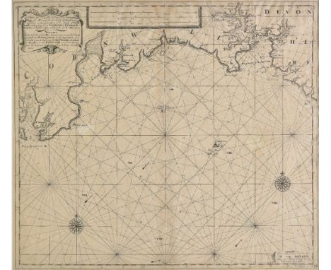
Devon & Cornwall. Van Keulen (Gerard), A new grad nally encreasing compass map of a part of the sea coasts of England, in which y contanied a part of the coasts of Cornwall extending to Big Berry to Falmouth..., published Amsterdam [1728 or later], uncoloured engraved sea chart, compass rose and numerous rhumb lines, title repeated in Dutch, slight overall toning, 525 x 595 mm, mounted, together with Collins (Captain G.), Untitled sea chart of south west Cornwall and the Scilly Isles, circa 1700, hand coloured engraved chart, compass rose and numerous rhumb lines, some dust soiling, 455 x 575 mm, mounted (2)
Devon. Pine (John), Untitled map showing the progress of the Spanish and English fleets during the attempted invasion by the Spanish Armada, 1739, two engraved maps on one sheet (as published), showing the southern coastline of Devon, maps printed in blue, with a decorative allegorical border, trimmed to plate mark with margins extended, 375 x 605 mm, together with Blaeu (Johannes), Devonia vulgo Devon-shire, circa 1658, engraved map with contemporary outline colouring, slight dust soiling, slight creasing, central fold partially strengthened on verso, 390 x 500 mm, Spanish text on verso, with Donn (Benjamin), Untitled maps of parts of Devon, 1765, two engraved sheets (numbers 3 & 4 only) from Donn's monumental large scale map of Devon, contemporary outline colouring, sheet three has the dedication and sheet four has the large engraved plan of Exeter, sheet four with sparse additional manuscript marginalia, each sheet approximately 613 x 485 mm, with another nine regional, county and road maps, including examples by Senex, Cary, Seller/Grose, Archer, Dawson and Cruchley, occasional duplicates, various sizes and condition (13)
Durham. Kitchin (Thomas), An accurate map of the county palatine of Durham improved from the best surveys & intelligences and divided into its wards..., published C & J Bowles and Robert Sayer, [1767], engraved map with contemporary outline colouring, slight spotting, 525 x 685 mm, together with Blaeu (Johannes), Episcopatus Dunelmensis vulgo The Bishoprike of Durham, published Amsterdam, circa 1660, engraved map with contemporary outline colouring, some water staining, largely confined to margins, some overall toning, 380 x 500 mm, Spanish text on verso, with Morden (Robert), Episcopatus Dunelmensis vulgo The Bishoprick of Durham, [1695 or later], hand coloured engraved map, 365 x 420 mm, with another nine county and regional maps and a sea chart, including examples by Moule, Cole & Roper, Kitchin, Cary, Collins and Greenville Collins, occasional duplicates, various sizes and condition (12)
East Anglia. Blaeu (Johannes), Lincolnia comitatus Anglis Lincoln-shire, Nortfolcia Norfolke, Huntingdonensis comitatus Huntington Shire [and] Regiones Inundatae in sinibus comitatus Norfolciae, Suffolciae, Cantabrigiae, Huntingtoniae, Northamtoniae et Lincolniae, published Amsterdam circa 1648, together five engraved maps with contemporary hand colouring, each map heavily stained, each approximately 440 x 540 mm, Latin text on verso (5)
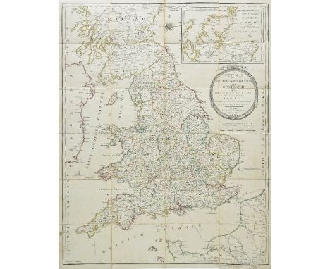
England & Wales. Lewis (Samuel), A map of England & Wales, divided into counties, parliamentary divisions and dioceses, shewing the principal roads, railways, rivers & canals..., published S. Lewis and Co., 1841, engraved map with contemporary outline colouring, sectionalised and laid on linen on four sheets, large calligraphic title, compass rose, table of explanation, uncoloured vignette of the General Post Office London, table of the distances from port to port and a table of dioceses, each sheet approximately 1040 x 870 mm, each section bound in contemporary morocco gilt boards, spines a little frayed and worn, one board detached, together with A map of Scotland divided into counties, shewing the principal roads, railways, rivers, canals, lochs, mountains, islands &c., published S. Lewis & Co., 1840, engraved map with contemporary outline colouring, sectionalised and laid on linen on three sheets, calligraphic title, table of explanation, compass rose and an uncoloured vignette of Melrose Abbey, 630 x 1290 mm, bound in contemporary morocco gilt boards, frayed and worn, lacking two spines (7)
England & Wales. Bowles (Carington, publisher), Bowles new pocket guide through England & Wales: Comprehending all the great principal cross roads with the distances on each in measured miles, circa 1780, engraved map with contemporary outline colouring, sectionalised and laid on linen, 555 x 480 mm, contained in a contemporary card slipcase, worn and frayed, together with, Cary (John), Cary's Pocket Companion to the Roads of Great Britian shewing all the post & market towns with the days prefixed on which they are held and the exact distances from the metropolis, 1791, engraved map with contemporary outline colouring, sectionalised and laid on linen, inset map of Scotland, additional title in French above map, 560 x 460 mm, contained in a contemporary marbled card slipcase, slight wear to extremities, with, Rocque (John), The Traveller's Companion or the post roads of England and Wales with the distances in measured miles..., published Laurie & Whittle, 1794, engraved map with contemporary outline colouring, sectionalised and laid on linen, 535 x 525 mm, contained in a contemporary marbled card slipcase with publisher's printed label to upper board, worn and frayed, plus Sayer (Robert), A new Map of the Roads of England and Scotland with the distances in measured miles from place to place..., 1789, engraved map with contemporary outline colouring, sectionalised and laid on linen, inset map of 'Continuation of the roads of Scotland' 745 x 590 mm, contained in a contemporary marbled card slipcase with publisher's printed label to upper board, and Faden (William, publisher), A New Map of England, Wales & Scotland describing all the direct and principal cross roads in Great Britain with the distances measured between the market towns and from London to accompany Paterson's Book of the Roads, 1801, engraved map with contemporary outline colouring, sectionalised and laid on linen, inset map of Scotland, slight overall toning, 730 x 610 mm, contained in a contemporary card slipcase, heavily worn and frayed (5)
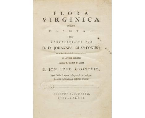
Gronovius (Jan Frederik). Flora Virginica exhibens plantas, quas Johannes Claytonus, in Virginia crescents observavit, collegit et obtulit, 2nd edition, Leiden, 1762, engraved folding map of Virginia, contemporary marginalia, a few pressed flowers loosely inserted, edges untrimmed, original wrappers bound in, contemporary calligraphic ownership inscription of one M. Davies to front panel verso, offset partially onto title, variable light spotting (the map clean), small marginal hole in sig. R2, 19th-century black quarter cloth, marbled sides, slightly rubbed, tips worn, 4to The first edition to contain the important map of Virginia, "one of the earliest botanical maps of any region of the world" (Stephenson and McKee, Virginia in Maps, p. 106). The work was "the first flora of Virginia" (Sowerby), and Jefferson used this second edition for his Notes on the State of Virginia, referring to Clayton as "our great botanist". Hunt 571; Sabin 28294; Sowerby, Library of Thomas Jefferson 1075. (1)
Europe. Arrowsmith (Aaron), Map of Europe drawn from all the best surveys and rectified by astronomical observations, published A. Arrowsmith, 1798, large engraved map with contemporary outline colouring, sectionalised and laid on linen on two sheets, large uncoloured decorative cartouche, dedication to Joseph Banks, each sheet approximately 745 x 1255 mm, contained in a contemporary marbled card slipcase with printed label to upper board, slipcase heavily worn and frayed (1)

Europe. National Savings Committee (publisher), The National Savings picture map of the continent of Europe..., 1945, colour lithographic pictorial map by H. Charles Paine, old folds, slight staining, 720 x 970 mm, together with Illustrated Map of the Holy Land for use in Schools issued by the National Savings Movement, circa 1945, colour lithographic pictorial map, old folds with some creasing and slight abrasion to folds, 985 x 740 mm, with Duckham's Historical Map of the City of London, circa 1966, colour printed map, old folds, 715 x 1150 mm (3)

Europe. Senex (John), A New Map of Europe divided into its Empires, Kingdoms, States and Republics; Drawn from the most approved geographers with great improvements from the Sieurs D'Anville & Robert, published Robert Sayer, circa 1760, large engraved map with contemporary hand colouring, slight dust soiling, some creasing, occasional marginal closed tears, one closed tear affecting image, 585 x 935 mm (1)

Geological maps. Ramsay (Andrew C.), Geological Map of England & Wales, 3rd edition, published Edward Stanford, 1866, lithographic map with contemporary hand colouring, sectionalised and laid on linen, table of explanation and six inset geological profiles, slight spotting, publisher's printed endpapers, 960 x 820 mm, contained in a contemporary blue cloth gilt slipcase, some wear to extremities, together with Geikie (Sir Archibald), Geological Map of England & Wales, [1897], colour printed map, sectionalised and laid on linen, table of reference and four geological profiles, slight spotting, 1000 x 815 mm, bound in contemporary blue cloth gilt boards, bumped and worn at extremities, with another copy similar, with Phillips (John), Geological Map of the British Isles and adjacent coast of France, 1847, engraved map by J. W. Lowry, contemporary hand colouring, sectionalised and laid on linen, inset map of the Shetland Islands, tables of explanation, slight dust soiling, 805 x 620 mm, plus Woodward (Horace B. & Goodchild J. G.), Geological Map of England and Wales, published George Philip & Son, [1887], colour printed map, sectionalised and laid on linen, some spotting and staining, 630 x 520 mm, and Ravenstein (E. G.), Geological Map of England, Wales and the Southern part of Scotland, published James Reynolds, [1861], engraved map with contemporary hand colouring, sectionalised and laid on linen, table of reference, 780 x 630 mm, marbled endpapers, bound in contemporary cloth gilt, a little faded and worn (6)
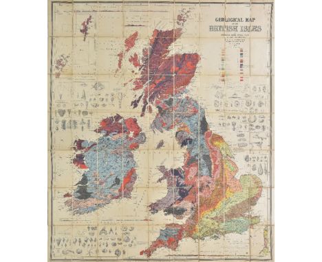
Geological Maps. Geikie (Archibald), Geological Map of the British Isles, published W. & A. K. Johnston, Edinburgh, 1864, colour printed lithographic map, sectionalised and laid on linen, inset map of the Orkney & Shetland Islands, table of explanation, illustrated with numerous inset illustrations of fossils, 1265 x 1075 mm, marbled endpapers with manuscript title label to upper cover Uncommon, Most of Geikie's maps are of England & Wales only. The engravings of fossils are from different geological periods. (1)
Herefordshire. Bowen (Emanuel), An accurate map of Hereford Shire divided into its hundreds drawn from the best maps and surveys..., published J. & C. Bowles & Robert Sayer [1767], engraved map with contemporary outline colouring, small area of professional restoration to lower margin not affecting image, 525 x 705 mm, together with Greenwood (C. & J.), Map of the County of Hereford from an actual survey made in the year 1831..., published 1834, engraved map with contemporary hand colouring, vigenette of Hereford cathedral, slight offsetting, 585 x 705 mm (2)

Herefordshire. Blaeu (Johannes), Herefordia comitatus. Hereford-shire, published Amsterdam, circa 1660, engraved map with contemporary hand colouring, some staining and dust soiling, largely confined to margins, 410 x 500 mm, Spanish text on verso, together with Harrison (J.), A Map of Herefordshire engraved from an actual survey, 1789, hand coloured engraved map, 330 x 460 mm, with Morden (Robert), Herefordshire, [1695 or later], hand coloured engraved map, 365 x 420 mm, with another twelve county maps of Herefordshire, including examples by Moule, Ellis, Bowen, Kitchin, Cary, Pigot and Collins, occasional duplicates, various sizes an condition (15)

Hungary. Senex (John), A New Map of the Kingdom of Hungary and of the Countries, Provinces &c. Bordering there upon with their Respective Bannats, Counties, Sanjiacships, Mountains, Passes, Post Roads, Cities, &c....., published T. Bowles, John Bowles & Son and Robert Sayer, circa 1760, engraved map with contemporary hand colouring, upper border with thread margin, old folds, 660 x 1005 mm (1)


Ireland. Ballynahinch Spa, circa 1880, anonymous ink and watercolour plan of Ballynahinch in County Down, Northern Ireland, slight creasing and staining, 320 x 240 mm, mounted, together with Hondius (Gerard), Udrone, circa 1608, engraved map with contemporary hand colouring, slight text showthrough, 135 x 175 mm, mounted, with Mercator (Gerard and Hondius Henricus), Udrone Irlandiae in caterlag baronia, circa 1630, hand coloured engraved map, some overall dust soiling, 350 x 280 mm, Latin text on verso, plus Jansson (Jan), Provincia Connachtiae. The Province of Connaugt, circa 1650, engraved map with contemporary hand colouring, heavily toned and spotted, occasional marginal closed tears, 390 x 490 mm, Latin text on verso, with another fifteen regional and county maps, including examples by Weller and Bartholomew, various sizes and condition (19)

Ireland. Senex (John), Ireland Corrected from the Latest Observations Divided into its Provinces, Counties & Baronies, Shewing the Principal Roads and the Distances of Places in Common Reputed Miles by Inspection, Where Barracks are Erected &c., 1712 [or later], engraved map with contemporary hand colouring, inset map of the British Isles, slight staining, trimmed to printed margin on right hand vertical margin, occasional repaired marginal closed tears, 970 x 670 mm (1)
*Italy. Chatelain (Henry Abraham), Carte du Plan de Venise, L'État de sa Noblesse et ses Differens Degrez avec Quelques Autres remarques Curieuses sur cette Superbe Ville, n.d., c.1728, hand coloured engraved town plan with five columns of text below image, slight paint staining to margins not affecting image, 390 x 470 mm, together with De Vaugondy (Gilles Robert),Partie Méridionale du Royaume de Naples où se trouvant La Calabre et L'Isle et Royaume de Sicile, Paris, 1750,hand coloured engraved map, decorative cartouche and mileage scale, inset map of Malta, 485 x 685 mm, plus Depot de la Marine (pubs.),Mer Mediterranée seconde Feuille contenant L'Italie, Sicile, Golphe de Venise, Costes de Dalmatie, Albanie et Partie de celles de Barbarie, circa 1820, hand coloured sea chart, numerous rhumb lines, slight creasing and dust soiling, 760 x 540 mm (3)

Hedin (Sven). Trans-Himalaya, Discoveries and Adventures in Tibet, 2 volumes, 1st edition, 1909, black & white plates, maps, etc., top edge gilt, remainder untrimmed, original cloth gilt, spines a little faded and short split at head of upper joint of volume 2, together with Fortune (Robert), A Journey to the Tea Countries of China; including Sung-lo and the Bohea Hills..., 1st edition, 1852, additional engraved title-page printed in red and black, 16 lithographed and engraved plates and map, correct as listed, occasional spotting, armorial bookplate, contemporary half vellum, dust-soiled, plus Hooker (Joseph Dalton & Ball, John), Journal of a Tour in Marocco and the Great Atlas, 1st edition, 1878, eight engraved plates including folding maps and plans, large folding map at rear crudely repaired to verso along folds, occasional heavy spotting, ink library stamp to title and front flyleaf, printed label to front pastedown, inner hinges cracked, contemporary half calf gilt, heavily rubbed, all 8vo, plus three further travel and topography titles (8)
-
109198 item(s)/page